

- Of all the Peninsular rivers, the Godavari is the largest, by both length and basin.
- It is called the Dakshin Ganga or Vridha Ganga (old Ganga), because of its age, size and length.
- An older ranking holds only the Ganga and the Indus in greater reverence.
- It is navigable in the delta region, for a stretch of about 300 km up from its mouth in older accounts.
The Godavari River and Its Basin
Course
- Source: it rises at Trimbak (Trimbakeshwar) in the Western Ghats, in Nashik district of Maharashtra, at 1,067 m and only about 80 km from the Arabian Sea.
- Length: 1,465 km from origin to outfall in the Bay of Bengal.
- Upper course: a narrow rocky bed as far as Nashik. Below it the valley opens out.
- Middle course: it crosses the rolling Deccan plateau, gathering most of its water from the left bank.
- Gorge: below the Indravati confluence it passes through the Eastern Ghats in a gorge of about 60 km, roughly 200 m across, lying some 100 km short of the mouth. It is thought to be fault-guided.
- Delta: below Rajahmundry it splits in two: the Gautami Godavari to the east and the Vashishta Godavari to the west.
- It then builds a large delta on the Bay of Bengal.
- The delta is of lobate type, with a rounded bulge and many distributaries. Its seaward front runs for about 120 km, and it reaches some 35 km out.
- Silting at the mouth continues, so the delta is still growing seaward.
Basin
- States: Maharashtra, Telangana, Andhra Pradesh, Chhattisgarh and Odisha, with smaller parts in Madhya Pradesh, Karnataka and the Union Territory of Puducherry (Yanam).
- Older lists omit Telangana, formed in 2014, and count its share under Andhra Pradesh.
- Area: about 3 lakh sq km, more exactly 3,12,812 sq km, or 9.5% of India. The 2019 Central Water Commission (CWC) assessment gives 3,12,150 sq km.
- Maharashtra holds nearly half, at about 1,52,199 sq km. It is India’s largest Peninsular basin, and larger than the Indian part of the Brahmaputra basin.
- Bounded by the Satmala hills, the Ajanta range and the Mahadeo hills on the north, the Eastern Ghats on the south and east, and the Western Ghats on the west.
- Water: older mean flow is about 105,000 million cubic metres. The 2019 CWC figure is 117.74 billion cubic metres, the largest among the Peninsular rivers.
- Land use: agricultural land covers 59.57% of the basin.
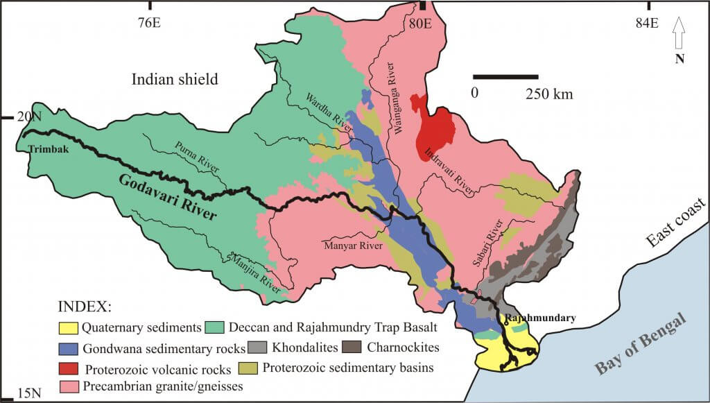
- Geology: the river crosses most of the Peninsula’s rock systems in turn.
- Deccan Traps in the upper basin, then Archaean granites and Dharwars.
- Cuddapah, Vindhyan and Gondwana rocks in the lower middle basin, the last with thick coal seams.
- Khondalites and charnockites of the Eastern Ghats, then Rajahmundry sandstones and delta alluvium at the coast.
- Rainfall: a belt east of the Western Ghats, in Aurangabad and Ahmednagar, receives under 600 mm. Rainfall rises again towards the east coast.
- Regime: the river stays low until May, then rises steeply to a peak in August, of about 15,000 cumecs at Polavaram on a monthly mean. It falls sharply after that, though October and November still run higher than January to May.
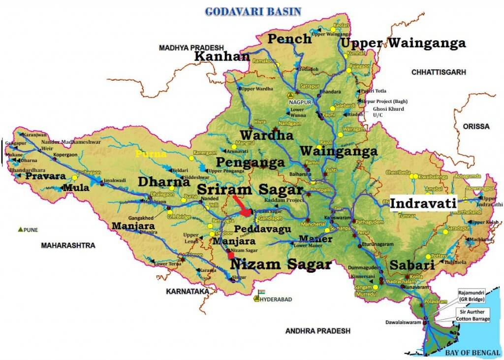
Cities and Early Works
- Nashik, Trimbakeshwar, Nanded, Aurangabad, Nagpur, Bhadrachalam, Nizamabad, Rajamundry (Rajahmundry), Balaghat, Yanam and Kovvur are its important urban centres. Several of them, such as Nagpur and Aurangabad, stand on tributaries or in the basin rather than on the main river.
- Largest city: older accounts call Rajahmundry the largest on its banks. On Census 2011 figures, Nashik is much larger, and Rajahmundry is the largest on the lower course.
- Sri Ram Sagar project: built on this river in about 1964–69 in older accounts, it irrigates Adilabad, Nizamabad, Karimnagar and Warangal districts.
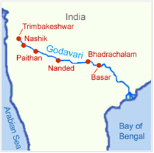
- On this small map, Bhadrachalam and Basar are swapped. Basar lies upstream, near Nizamabad, and Bhadrachalam far downstream.
Tributaries of the Godavari
Pattern
- Important tributaries: the Pravara, Indravati, Wainganga, Wardha, Pench, Kanhan, Penganga, Manjira, Bindusara and Sabari.
- Left-bank streams are more numerous and larger than those on the right.
- On the right, only the Manjra (724 km) is of real size. It joins after passing through the Nizam Sagar.
| Bank | Tributaries |
|---|---|
| Left | Penganga, Wainganga, Wardha, Pranahita (carrying the Penganga, Wardha and Wainganga), Pench, Kanhan, Sabari, Indravati, Purna |
| Right | Dharna, Pravara, Mula, Manjra, Peddavagu, Maner |
- Pranhita: the largest tributary, carrying about 34.87% of the drainage area. It joins below Sironcha, and the Indravati follows about 48 km downstream.
- Sabari: the last major tributary, joining about 100 km upstream of Rajahmundry.
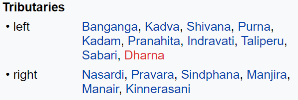
- Dharna: older lists, including the image below, place it on the left. CWC records it joining on the right bank, about 64 km from the source.
Manjra
- A right-bank tributary, it rises in the Balaghat range, near Ahmednagar, at 823 m.
- It flows through Latur District of Maharashtra and Bidar District of Karnataka, then enters Medak District, now in Telangana.
- It runs about 96 km in Medak, through Narayankhed, Jahirabad, Sangareddy and Narsapur Talukas.
- It meets the Godavari at Basara near Nizamabad.
- The Valdi river is its tributary.
- Nizam Sagar stands across it between Achampeta and Banjapalle villages of Nizamabad district.
- Its best-known feature is a huge masonry dam about 3 km long, carrying a motorable road 14 feet wide.
Painganga
- Also written Penganga or Panuganga, it is 676 km long and rises in the Ajantha ranges of Aurangabad district, Maharashtra.
- It passes through Buldhana and Washim districts, then forms the boundary between Yavatmal and Nanded districts.
- Further on it follows the Maharashtra–Telangana border, once described as the border with Andhra Pradesh.
- It joins the Wardha near Wadha in Wani Tehsil of Yavatmal district.
- It is deeply entrenched and cannot be navigated.
- It irrigates Washim and Yavatmal districts.
- Dams: Upper Painganga and Lower Painganga. The upper dam is known as Isapur Dam.
- Adan is its major tributary.
- It passes through the Painganga Wildlife Sanctuary.
- Sahastrakund waterfalls lie on it.
Wardha
- One of the biggest rivers of the Vidarbha region.
- It rises at 777 metres in the Satpura Range near Multai, in Betul District of Madhya Pradesh, about 70 miles north-west of Nagpur.
- It flows 32 km in Madhya Pradesh before entering Maharashtra.
- After 528 km (older length 483 km) it joins the Wainganga. Together they form the Pranhita, which falls into the Godavari.
- Left tributaries: Kar, Wena, Jam and Erai.
- Right tributaries: Madu, Bembla and Penganga.
- Upper Wardha Dam, near Morshi, is a lifeline for Amravati city.
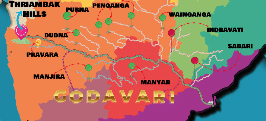
- This map’s “Thriambak” is Trimbak, and its “Manyar” is the Maner.
Wainganga
- The name means “the arrow of water”.
- It rises about 12 km from Mundara village of Seoni (Sconi) district, on the southern slopes of the Mahadeo Hills of the Satpura Range.
- It winds south through Madhya Pradesh and Maharashtra for about 360 miles, roughly 580 km.
- After meeting the Wardha, the united stream, the Pranahitha, falls into the Godavari.
- It drains Chandrapur, Gadchiroli, Bhandara, Gondia and Nagpur districts of Maharashtra.
- Left-bank tributaries: Thel, Thanwar, Bagh, Chulband, Garhavi, Khobragadi and Kathani.
- Right-bank tributaries: Hirri, Chandan, Bawanthari, Kanhan and Mul.
- Urban and industrial centres: Kamptee, Bhandara, Tumsar, Balaghat and Pauna.
Nag River
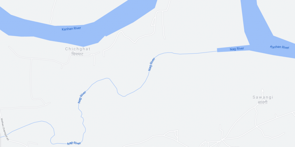
- Nagpur takes its name from the Nag river, which passes through the city.
- It starts at Ambazari Lake in west Nagpur.
- Pili river is its major tributary.
- It ends at the Kanhan River, which then meets the Pench to form the Kanhan–Pench system.
- The Kanhan is an important right-bank tributary of the Wainganga, draining a large area south of the Satpura range in central India.
Indravati
- It rises at Thuamul Rampur in the Eastern Ghats, in Kalahandi, Odisha (Orissa).
- It then flows through the Bastar region of Chhattisgarh for about 380 km, where it is the largest and most significant river and is known as the lifeline of Bastar.
- At places it marks the Maharashtra–Chhattisgarh boundary.
- It meets the Godavari at Bhadrakali, in what was Dantewada District and is now Bijapur district.
- Its rocky bed rules out navigation except near the Godavari confluence.
- Pamer Chinta is its largest tributary.
- The river and its tributaries do not dry up in summer.
- Chitrakoot Falls lies on the river, some 40 km from Jagdalpur.
- Indravati National Park and Tiger Reserve lie in the adjoining part of Chhattisgarh.
Development of the Basin
Projects on the Godavari River
- Plan-period works: Sriram Sagar, Godavari barrage, Upper Penganga, Jaikwadi, Upper Wainganga, Upper Indravati and Upper Wardha.
- Early delta works: the Dowlaiswaram and Ralli weirs, completed in 1846, feed canals irrigating about 4.5 lakh hectares.
- Ongoing projects in older accounts: the Pranahita–Chevella (Prnahita-Chevala) and Polavaram.
- Pranahita–Chevella was reworked in Telangana as the Kaleshwaram project.
- Polavaram is an Indira Sagar multipurpose dam near Ramayyapeta in Eluru district, declared a national project under the Andhra Pradesh Reorganisation Act, 2014.
- Design: full reservoir level of 45.72 m, 960 MW of power, 2.91 lakh hectares of command, and 80 tmc ft diverted to the Krishna.
- Status: Phase I, with storage limited to 41.15 m, is targeted for June 2027, as the Centre told the Lok Sabha on 6 August 2026.
- Issue: displacement is large. At October 2025 some 91,621 families were still to be moved, and Odisha, Chhattisgarh and Telangana raise submergence concerns.
- Godavari Water Disputes Tribunal: its award of 1980 set the framework for these projects. It rested on inter-State agreements, and it allowed Polavaram.
Industry in the Godavari Basin
- Major urban centres: Nagpur, Aurangabad, Nashik and Rajahmundry.
- Nashik and Aurangabad have many industries, especially automobiles.
- Most other industry uses farm produce: rice milling, cotton spinning and weaving, sugar and oil extraction.
- Cement and small engineering units also exist.
Floods and Droughts in the Godavari Basin
- Floods affect the lower reaches, especially below Polavaram.
- The coast is cyclone-prone.
- The flat delta suffers from drainage congestion.
- A large part of the Maharashtra section, Marathwada, is drought-prone.
Godavari and Cauvery River Interlinking Project
- Aim: older plans would divert 247 thousand million cubic feet (tmcft) of unused water in the Indravati sub-basin to needs between the Godavari and the Cauvery.
- Route: water is lifted from the Godavari to Nagarjuna Sagar dam, then sent south to meet the demands of the Krishna, Pennar and Cauvery basins.
- Three components make up the link:
- Godavari (Inchampalli/Janampet) – Krishna (Nagarjunasagar)
- Krishna (Nagarjunasagar) – Pennar (Somasila)
- Pennar (Somasila) – Cauvery (Grand Anicut)
- Benefit: irrigation of 3.45 to 5.04 lakh hectares in the Prakasam, Nellore, Krishna, Guntur and Chittoor districts of Andhra Pradesh.
- Current position: this is now a priority link of the National Water Development Agency.
- The interim proposal has shrunk to about 4,189 million cubic metres (about 148 tmc ft) of Chhattisgarh’s unused share, as reported in December 2025. The canal end has been moved to the Manimukhta, a Vellar tributary next to the Cauvery basin.
- Telangana objects, so consensus remains the main hurdle.
Previous Year Questions
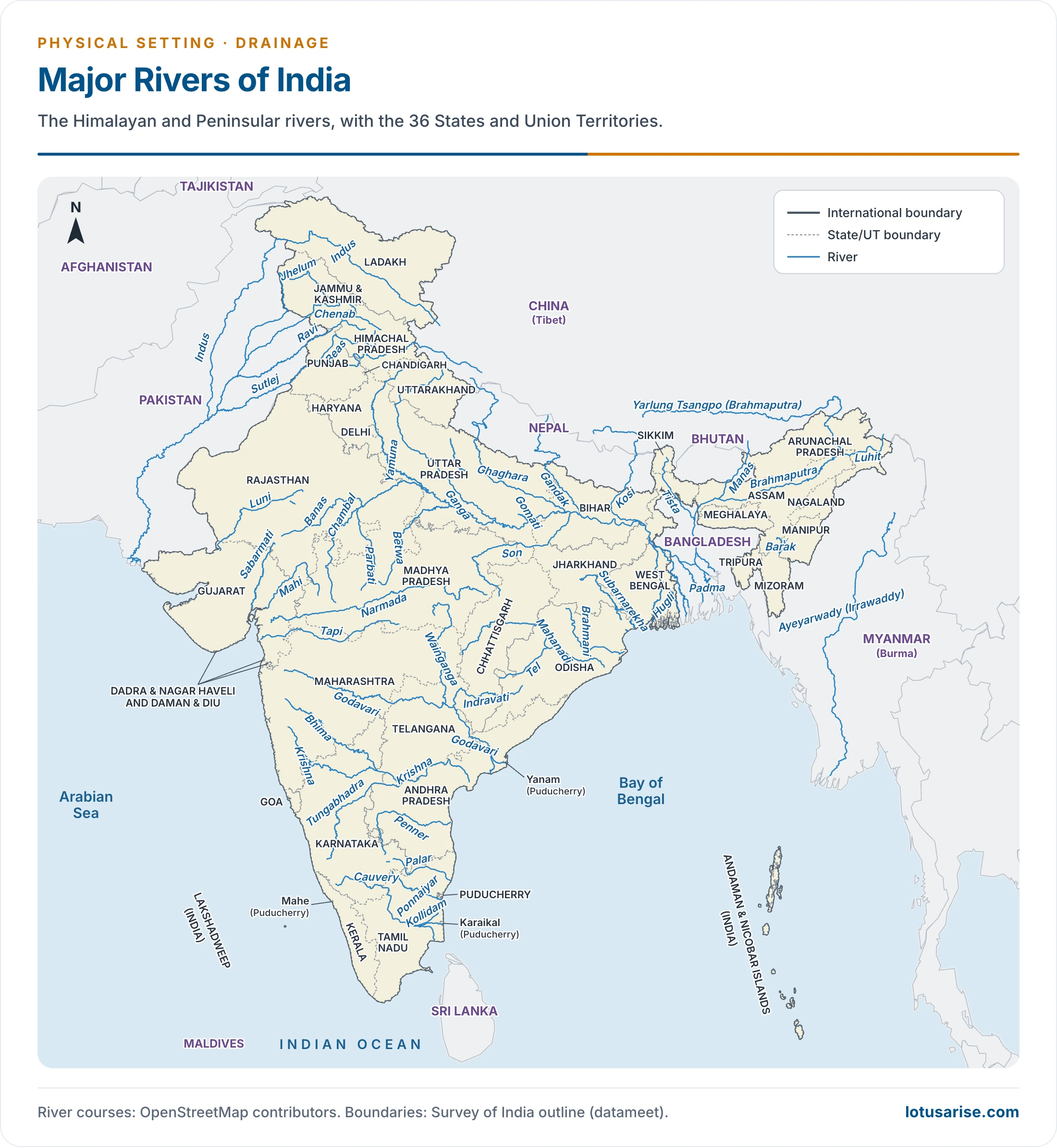
2016Map item: River Indravati2015Map item: Polavaram





It’s very usefull
This article help me alot
Really helpful👌
Super
Nice content 💯💯💯
Please provide pdf
Once shrusti ma’am suggested your channel and frm then not going back its going so smooth thank you sir
Keep Reading
Thanks a lot, very helpful
Thanks !! Very useful