

- Humidity is the water vapour content of the air at a given time and place. It refers only to the invisible gas, not to the droplets of fog, cloud or rain.
- Water vapour makes up from almost 0 to about 4% of the air by volume, yet it is the source of all clouds and precipitation, a major greenhouse gas and the carrier of latent heat that drives storms and balances the heat budget of the Earth.
- Moisture enters the air by evaporation and transpiration, and leaves it by condensation and precipitation. The air’s capacity to hold vapour is set by its temperature.
Atmospheric Humidity

Water Vapour and the Changes of State
- Water exists in three states: ice, liquid water and water vapour. Six changes of state link them, and each absorbs or releases latent heat (“hidden heat”).
- Heat is absorbed (and the surroundings cool) when ice melts, water evaporates or ice sublimates into vapour.
- Heat is released (and the air warms) when vapour condenses, water freezes or vapour turns directly into ice (deposition).
| Change | Process | Latent heat (approx.) | Effect on surroundings |
|---|---|---|---|
| Liquid → vapour | Evaporation | ~2,500 J/g (about 600 cal/g) | Cools |
| Vapour → liquid | Condensation | ~2,500 J/g released | Warms |
| Ice → liquid | Melting | ~334 J/g (about 80 cal/g) | Cools |
| Liquid → ice | Freezing | ~334 J/g released | Warms |
| Ice → vapour | Sublimation | ~2,830 J/g (about 680 cal/g) | Cools |
| Vapour → ice | Deposition | ~2,830 J/g released | Warms |
- The latent heat of condensation is the fuel of thunderstorms and tropical cyclones, and it slows the cooling of rising saturated air.
Saturation, Vapour Pressure and Capacity
- Vapour pressure (e) is the part of the total air pressure exerted by water vapour molecules.
- Over a water surface, molecules escape and return. When the two rates are equal the air is saturated, and the vapour pressure is the saturation vapour pressure (eₛ).
- The capacity of air for water vapour depends almost entirely on temperature and rises exponentially: about 7% more vapour for every 1 °C of warming (the Clausius–Clapeyron relation).
| Air temperature | Saturation mixing ratio (g/kg, near sea level) |
|---|---|
| −20 °C | about 0.8 |
| 0 °C | about 3.8 |
| 10 °C | about 7.7 |
| 20 °C | about 14.7 |
| 30 °C | about 27 |
| 40 °C | about 49 |
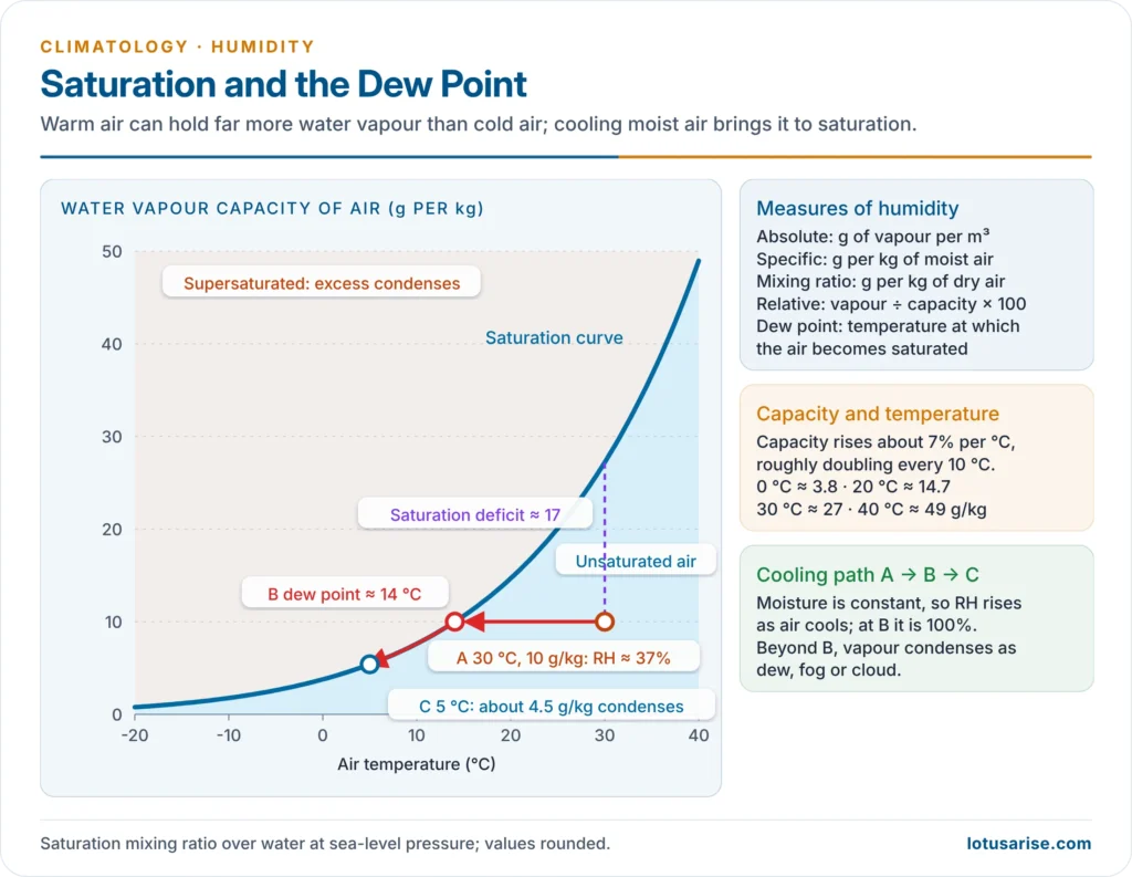
- Saturation deficit: the difference between the capacity of the air and the vapour actually present. It measures the drying power of the air.
- Supersaturation: air that holds more vapour than its saturation value without condensing.
- In the real atmosphere it rarely exceeds about 1%, because condensation nuclei are plentiful. In perfectly clean air, droplets would not form until the humidity reached several hundred per cent.
Measures of Humidity
| Measure | Definition | Usual unit | Behaviour |
|---|---|---|---|
| Absolute humidity | Mass of vapour per volume of air | g/m³ | Changes when air expands or contracts, so rarely used |
| Specific humidity | Mass of vapour per mass of moist air | g/kg | Conservative: unchanged by heating, cooling or pressure change unless vapour is added or removed |
| Mixing ratio (w) | Mass of vapour per mass of dry air | g/kg | w = 622 e / (p − e); nearly equal to specific humidity |
| Relative humidity (RH) | Actual vapour ÷ capacity at that temperature (or e ÷ eₛ) × 100 | % | Changes with both moisture and temperature |
| Dew point | Temperature to which air must cool, at constant pressure and moisture, to become saturated | °C | Direct index of the moisture content |
- Relative humidity falls when air warms and rises when it cools, even though the moisture content stays the same.
- So RH is usually lowest in the afternoon and highest just before dawn, the opposite of the daily temperature cycle.
- Air at 30 °C holding 10 g/kg has an RH of only about 37%; cooled to about 14 °C the same air is saturated.
- Humidity and comfort: sweat cools the body only by evaporating. High RH slows evaporation, so humid heat feels hotter than dry heat. A wet-bulb temperature of 35 °C is taken as the theoretical limit of human survival (Steven Sherwood and Matthew Huber, 2010).
- The Indian coasts and the Indo-Gangetic Plain before the monsoon combine heat with high dew points, which makes them the country’s most dangerous humid-heat zones.
Dew Point
- The dew point is the temperature at which air becomes saturated when cooled without any change in its moisture or pressure. Any further cooling causes condensation.
- Dew point depression (air temperature minus dew point) shows how close the air is to saturation. A small gap means humid air, fog or low cloud; a large gap means dry air.
- When the dew point lies below 0 °C it is called the frost point, and vapour turns directly into ice.
- How much cooling is needed depends on the humidity:
- In humid climates (Kerala, the Konkan, Bengal in the monsoon) a little cooling brings saturation, so dew, fog and low cloud are common.
- In deserts (western Rajasthan) the dew point is far below the air temperature, so the air must cool a great deal before condensation begins.
- Equatorial air has a higher dew point than air in high latitudes, because it holds much more vapour.
Distribution of Humidity
- Specific humidity is highest at the equator and falls steadily towards the poles, following temperature. It is higher over oceans than over continents and higher in summer than in winter.
- Relative humidity has a different pattern:
- High in the equatorial belt of rising, moist air
- Lowest under the subtropical high-pressure belts (20°–30° latitude), where air subsides and warms; the great hot deserts lie here
- Rising again poleward, because the cold air there needs little vapour to approach saturation
- The belts of highest and lowest RH shift north in July and south in January, following the overhead sun.
- In India, the monsoon transforms humidity: specific humidity over the north Indian plains climbs steeply from the dry pre-monsoon months to the monsoon season, while the Thar stays the driest part of the country.
Evaporation and Evapotranspiration
Evaporation
- Evaporation is the change of liquid water into water vapour. It supplies the atmosphere from oceans, lakes, rivers, moist soil and wet surfaces.
- It consumes latent heat (about 2,500 J for each gram), so it is a cooling process: rain falling through dry air chills it, and evaporation from the oceans removes much of the solar energy they absorb.
- The energy is released again wherever the vapour condenses, often far away. Evaporation therefore transfers heat from the oceans and low latitudes to the atmosphere and higher latitudes.
Factors Controlling the Rate of Evaporation
| Factor | Effect | Example |
|---|---|---|
| Water available | Unlimited over oceans, limited over land | Oceans evaporate far more than deserts |
| Temperature of the surface and air | Higher temperature, faster evaporation | Summer and midday maxima |
| Humidity (vapour pressure deficit) | Dry air evaporates more | Rajasthan in May–June |
| Wind speed | Removes the saturated layer and keeps the gradient steep | Hot, dry loo parches soil |
| Area of exposed surface | Larger area, more evaporation | Shallow reservoirs lose much water |
| Air pressure | Lower pressure aids evaporation | High plateaus |
| Salinity | Salt water evaporates about 5% more slowly than fresh water | Oceans versus lakes |
Evapotranspiration and Potential Evapotranspiration
- Transpiration is the loss of water vapour from plants through their stomata. Evapotranspiration (ET) is the combined loss by evaporation and transpiration from a vegetated surface.
- Potential evapotranspiration (PET) is the water that would be lost from a surface fully covered by vegetation if water were never in short supply. It measures the water need of a place.
- Actual evapotranspiration (AET) is what is really lost; it equals PET only where water is plentiful.
- PET is set mainly by energy: temperature, day length (latitude), radiation, humidity and wind.
- Estimating PET:
- Charles Warren Thornthwaite (1948) derived PET from mean monthly temperature adjusted for day length.
- Howard Latimer Penman (1948) combined an energy balance with an aerodynamic (wind and humidity) term; its modern form, the FAO Penman–Monteith equation, is the international standard for crop water needs.
- Water balance: comparing precipitation (P) with PET month by month gives a place’s water budget.
- P > PET: soil moisture is recharged and the excess becomes water surplus (runoff and groundwater).
- P < PET: soil moisture is drawn down, then a water deficit develops and crops need irrigation.
- Thornthwaite turned this into a moisture index and used it to classify climates.
- Indian use: PET-based water balances guide irrigation scheduling, drought monitoring and agro-climatic planning. Western Rajasthan has an annual water deficit, while the Western Ghats and the north-east have large monsoon surpluses that feed rivers and groundwater.
Condensation
- Condensation is the change of water vapour into liquid water (or directly into ice, by deposition, below freezing). It releases latent heat, which warms the air and slows its cooling.
Conditions Necessary for Condensation
- Saturation, reached in one of two ways:
- Cooling the air to its dew point (the main way)
- Adding vapour to the air by evaporation
- A surface to condense on:
- At the ground: grass, soil, leaves, cars
- In the free air: tiny condensation nuclei (aerosols)
- Hygroscopic (cloud condensation) nuclei attract water:
- Sea salt from ocean spray: the most effective nuclei
- Sulphates and nitrates from volcanoes, fuel burning and industry
- Dust, smoke and particles from forest fires and burnt-out meteors
- Sizes and numbers:
- Most nuclei measure about 0.1–1 micrometre; “giant” sea-salt nuclei reach several micrometres.
- Clean maritime air holds tens to hundreds of nuclei per cubic centimetre; polluted urban air can hold many tens of thousands. That is why industrial cities are hazy and foggy.
- Strongly hygroscopic nuclei begin to gather water at RH of about 75%, before saturation, which produces haze.
Processes of Cooling
| Process | Type | How it cools | Typical result |
|---|---|---|---|
| Expansion of rising air | Adiabatic | Air rises, expands and cools at about 10 °C/km (dry rate), then about 4–7 °C/km once saturated | Clouds and precipitation |
| Radiation | Non-adiabatic | Ground and air lose heat on clear nights | Dew, frost, radiation fog |
| Contact (conduction) | Non-adiabatic | Air touches a cold surface | Dew, frost |
| Advection | Non-adiabatic | Warm moist air moves over a cold surface | Advection fog, stratus |
| Mixing | Non-adiabatic | Two nearly saturated air masses of different temperature mix | Steam fog, frontal fog, contrails |
- Only adiabatic cooling can chill deep, extensive air masses enough to form clouds and heavy precipitation. Air is lifted by convection, mountain barriers, fronts and convergence.
- Non-adiabatic processes act on a thin surface layer and produce only dew, frost and fog.
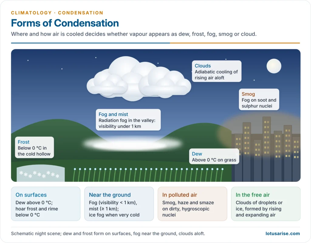
Forms of Condensation
- The form condensed moisture takes depends on where condensation happens, the temperature and the rate and depth of cooling.
| Where | Form | Above 0 °C | Below 0 °C |
|---|---|---|---|
| On surface objects | Deposits | Dew | Hoar (white) frost; rime from supercooled fog |
| In air near the ground | Suspended droplets | Fog, mist | Ice fog, frost-smoke |
| In polluted air | Droplets on dirty nuclei | Smog, haze, smaze | — |
| In the free air aloft | Suspended droplets or ice | Clouds (water) | Clouds (ice or supercooled water) |
Dew
- Dew is water condensed directly on cold surfaces (grass, leaves, stones) when they cool below the dew point of the air by night-time radiation and contact.
- Conditions: a clear sky (clouds blanket the ground and stop cooling), calm air (wind mixes the layer and prevents saturation) and fairly high humidity.
- Dew is a useful moisture source for plants in dry regions and is heavy in India’s post-monsoon and winter nights.
Frost
- Frost forms when the dew point is below 0 °C: vapour turns directly into ice crystals on surfaces. It is not frozen dew.
- White (hoar) frost: feathery ice crystals on grass and roofs
- Ground frost: the ground surface falls below 0 °C
- Killing frost: severe enough to destroy crops
- Rime: opaque ice built up on the windward side of objects when supercooled fog or cloud droplets freeze on contact (common on hill tops)
- Cold air drains into hollows and valleys, so valley floors are frost pockets while the slopes above stay warmer (the thermal belt of a valley temperature inversion).
- In India, December–January ground frost damages mustard, potato, gram, vegetables and young wheat in Punjab, Haryana, Rajasthan and western Uttar Pradesh.
- Protection: smudge pots and orchard heaters, wind machines that mix in warmer air, sprinkler irrigation (freezing water releases latent heat), and covers of straw, cloth or plastic.
Fog
- Fog is a cloud at or near the ground: tiny water droplets suspended in the surface air in such numbers that horizontal visibility falls below 1 km.
- Fog and cloud are physically alike; they differ in where and how they form. Clouds form by adiabatic cooling of rising air, while most fogs form by radiation, advection or mixing near the surface.
- Fog favours calm or light winds, high humidity, plenty of nuclei and stable air under an inversion.
Types of Fog
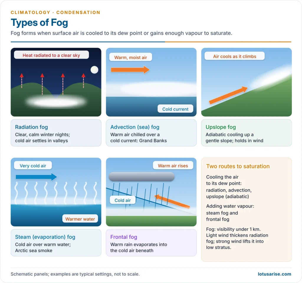
- Hurd Curtis Willett (1928) classified fogs by the process that forms them, which became the basis of fog forecasting: air-mass fogs and frontal fogs.
| Type | How it forms | Where and when | Example |
|---|---|---|---|
| Radiation (ground) fog | Clear, calm, long nights; ground radiates, air near it cools to the dew point; a light wind of 3–5 km/h thickens it | Over land, in valleys and anticyclones, winter; “burns off” after sunrise | Indo-Gangetic Plain, San Joaquin Valley (California) |
| High-inversion fog | Many days of radiation cooling under a persistent inversion | High-latitude continents in winter | Western Europe in winter |
| Advection (sea) fog | Warm, moist air moves over a cold current or cold land and is chilled from below | Coasts with cold currents, any season | Grand Banks (Gulf Stream air over the Labrador Current), San Francisco |
| Tropical-air fog | Tropical air moves poleward over progressively colder sea | Open oceans in mid-latitudes | North Atlantic, North Pacific |
| Steam (evaporation) fog | Cold air moves over warm water; evaporation saturates it | Lakes and rivers on autumn and winter mornings | Arctic sea smoke over open polar water |
| Upslope fog | Moist air cools adiabatically as it rises up a gentle slope; it persists even in moderate wind | Rising plains and hill slopes | “Cheyenne fog” of the US Great Plains |
| Frontal fog | Warm rain falling from the overriding air evaporates into the cold air beneath | Ahead of warm fronts, behind slow cold fronts | Mid-latitude cyclones |
- Distribution:
- Most fog over the world is advection fog over the oceans, linked with cold currents. The western coasts of the tropics and subtropics, washed by cold currents, are among the foggiest places on Earth: the Atacama (camanchaca), Peru (garúa) and the Namib.
- Radiation fog is a winter, continental feature; it is rare over the oceans and uncommon in the tropics.
- Coastal areas have more fog in summer, continental interiors more in winter.
- Visibility classes: fog is graded by visibility, from dense fog (objects about 50 m away hidden) to thin fog (visibility near 1 km).
Fog in India
- From mid-December to January, dense radiation fog blankets the Indo-Gangetic Plain from Punjab to Bihar.
- It forms under winter anticyclones and long clear nights, with moisture left behind by western disturbances, irrigated fields and rivers, and abundant aerosols from stubble and biomass burning, vehicles and industry.
- It disrupts flights, trains and road traffic every winter; airports such as Delhi use CAT III landing systems to operate in very low visibility.
- The Winter Fog Experiment (WiFEX), run since winter 2015 at Delhi’s Indira Gandhi International Airport, now forecasts very dense fog (visibility below 200 m) with over 85% accuracy.
- Urban effect: satellite data for 2000–2016 show “fog holes” over Delhi, where the urban heat island keeps the air above its dew point while fog covers the surrounding plain (Ritesh Gautam and Manoj K. Singh, 2018).
Fog Dissipation
- Natural: fog clears when the air is warmed (sunshine after sunrise, so radiation fog lifts from the bottom up), when wind and turbulence mix in drier air from above, or when air descends and warms adiabatically.
- Artificial:
- Heating the air with burners cleared British airfields in the Second World War, but it was costly.
- Seeding supercooled fog with dry ice, silver iodide or liquid propane turns droplets into ice crystals that fall out; this works only below freezing.
- Warm fogs, the common type, are harder to clear: only mixing with drier air (for example, helicopter downwash over shallow fog) helps.
Mist, Haze, Smog and Smaze
| Form | What it is | Visibility |
|---|---|---|
| Mist | Thinner suspension of droplets in moist air | 1 km or more |
| Haze | Dry dust, smoke or salt particles, or nuclei swollen at RH below saturation | Reduced, bluish or yellowish |
| Smog (smoke + fog) | Fog formed on soot and sulphur-rich nuclei in polluted air; persists because the smoke screens sunlight | Often under 1 km |
| Photochemical smog | Brown haze from sunlight acting on vehicle exhaust (nitrogen oxides, hydrocarbons) to form ozone | Hazy; summer, sunny cities |
| Smaze | Smoke mixed with haze | Reduced |
- London’s Great Smog (5–9 December 1952): an anticyclone and inversion trapped coal smoke in fog. About 4,000 people died within days and later estimates put the toll at 10,000–12,000, leading to the Clean Air Act 1956.
- Los Angeles gave its name to photochemical smog. Delhi and the Indo-Gangetic Plain now suffer both kinds: winter fog-smog from November to January and summer ozone.
- In the Arctic, extremely cold air over unfrozen water forms frost-smoke of ice crystals; in the mountains of the western United States such ice fog is called pogonip.
Clouds
- Clouds are condensation aloft: visible masses of water droplets and/or ice crystals formed when rising air cools adiabatically to its dew point at the condensation level. By height and form they fall into ten cloud genera, from high cirrus to towering cumulonimbus.
- When cloud droplets grow large enough to fall, condensation becomes precipitation, which completes the atmospheric part of the water cycle.
Previous Year Questions
2015What is Potential Evapotranspiration? Explain how it is used in assessing the water balance in an area.2013Discuss Dew point and the various forms of condensation.2010Examine the various kinds of atmospheric humidity and their associated forms.2004Write short note on Potential evapotranspiration.




