

- Atmospheric stability is the tendency of the air to resist vertical motion. Instability is its tendency to favour and amplify vertical motion.
- Vertical motion matters more for weather than horizontal motion. Large-scale condensation needs cooling, and the only cooling strong enough to produce heavy cloud and rain is adiabatic cooling of rising air.
- So whether air is stable or unstable decides whether a day brings clear skies, fog and smog, flat layer clouds and drizzle, or towering cumulonimbus, thunderstorms, hail and tornadoes.
- Stability is judged by comparing two temperature changes with height: that of the surrounding air (the environmental lapse rate) and that of a rising parcel of air (the adiabatic lapse rates).
Adiabatic Processes and Lapse Rates

Adiabatic Temperature Change
- An adiabatic process is one in which a parcel of air changes temperature without exchanging heat with its surroundings; the change comes only from expansion or compression.
- Rising air moves into lower pressure, expands and uses its own internal energy to do so, so it cools.
- Sinking air is compressed and warms.
- Air at about 5.5 km is under roughly half the sea-level pressure, so a parcel lifted there roughly doubles in volume.
- Its heat content stays the same, even though its temperature changes; this is what makes the process adiabatic rather than radiative or conductive.
- Adiabatic warming explains the warm, dry föhn and chinook winds on leeward slopes; adiabatic cooling explains almost all cloud and precipitation.
The Three Lapse Rates
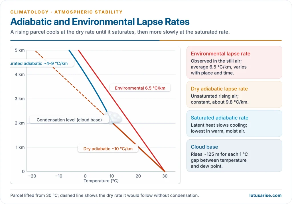
- Environmental (actual) lapse rate (ELR):
- the observed fall of temperature with height in the still air around a parcel, measured by radiosondes
- averages 6.5 °C per km (the normal lapse rate) but varies with place, time, season and height; it is steep over hot ground on summer afternoons and negative in an inversion
- Dry adiabatic lapse rate (DALR):
- the rate at which unsaturated air cools on rising (or warms on sinking)
- constant at about 9.8 °C per km, usually taken as 10 °C per km (1 °C per 100 m), whatever the air’s temperature
- Saturated (wet, moist) adiabatic lapse rate (SALR):
- Once rising air reaches its dew point, condensation releases latent heat, which offsets part of the expansional cooling.
- So saturated air cools more slowly, at about 4–9 °C per km, often taken as about 5–6 °C per km in the lower troposphere.
- It is lowest in warm, moist air, which holds more vapour and releases more latent heat, and approaches the DALR in very cold air high up, where little vapour is left.
- Sverre Petterssen distinguished the pseudo-adiabatic rate, where condensed water falls out at once, from the retarded (saturation) adiabatic rate, where it is carried along.
- Lifting condensation level (LCL):
- A rising parcel cools at the DALR until it saturates; that height is the condensation level, the base of the cloud. Above it the parcel cools at the SALR.
- The LCL rises by about 125 m for every 1 °C of gap between temperature and dew point, so dry air has high cloud bases and humid air low ones.
| Lapse rate | What it describes | Value | Varies? |
|---|---|---|---|
| Environmental (ELR) | Still air around the parcel | Average 6.5 °C/km; may be negative | Yes, with place and time |
| Dry adiabatic (DALR) | Rising or sinking unsaturated parcel | About 9.8–10 °C/km | No (constant) |
| Saturated adiabatic (SALR) | Rising saturated parcel | About 4–9 °C/km | Yes, with temperature and moisture |
Stability, Instability and Equilibrium
The Idea of Equilibrium
- Stable equilibrium: a body pushed slightly returns to its position, like a cone resting on its base or a ball in a bowl.
- Unstable equilibrium: a body pushed slightly moves further away, like a cone balanced on its tip or a pencil on its end.
- Neutral equilibrium: a body stays wherever it is pushed, like a ball on a flat table.
- The atmosphere follows the same logic, with two complications:
- air is compressible, so a moving parcel changes its density as it rises or sinks
- latent heat released on condensation changes the parcel’s temperature and density
The Parcel Test
- Imagine lifting a small parcel of air. It takes on the pressure of its new surroundings at once, so its buoyancy depends on temperature alone:
- Parcel colder (denser) than its surroundings: it sinks back, so the air is stable.
- Parcel warmer (lighter): it keeps rising, so the air is unstable.
- Parcel at the same temperature: it stays put, so the air is neutral.
- In practice the test compares the ELR with the DALR (for unsaturated air) and the SALR (for saturated air). Meteorologists plot these on a tephigram or skew-T chart from each radiosonde ascent.
Types of Stability and Instability
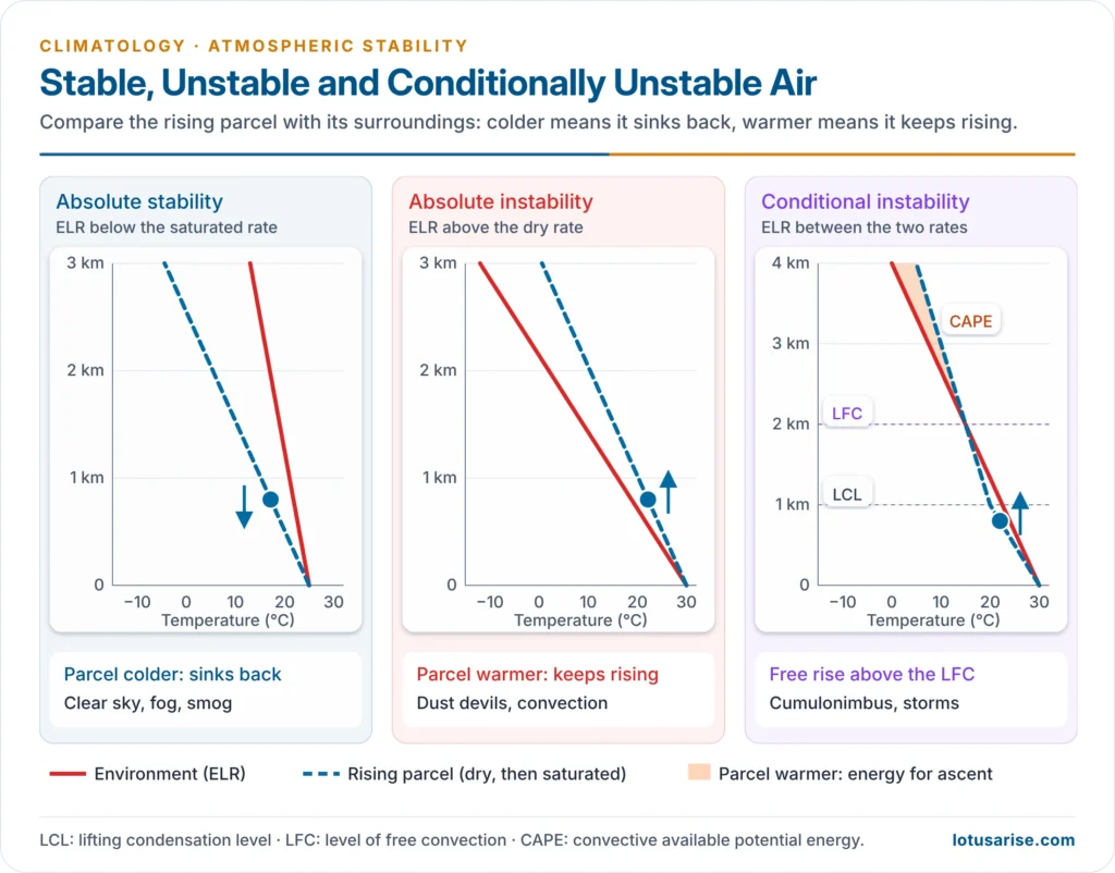
- Absolute stability (ELR < SALR):
- The environment cools more slowly than even a saturated parcel, so any lifted parcel, dry or saturated, ends up colder than its surroundings and sinks back.
- Typical of inversions and isothermal layers, which are the extreme case: smoke from chimneys spreads out flat at the inversion base.
- Absolute instability (ELR > DALR):
- The environment cools faster than even a dry parcel, so any lifted parcel ends up warmer and keeps rising until its temperature matches its surroundings.
- A lapse rate steeper than the dry adiabatic is called super-adiabatic. It occurs only in a shallow layer over strongly heated ground on sunny afternoons, giving dust devils and shimmering air; over tropical land it is common in the lowest 100–200 m on dry-season afternoons.
- Mechanical (autoconvective) instability:
- When the ELR exceeds about 34 °C per km, the air above is denser than the air below and overturns on its own, without any trigger.
- It occurs only in very thin layers over intensely heated surfaces, and is linked with tornadoes and violent whirlwinds.
- Neutral equilibrium (ELR = DALR for dry air, or = SALR for saturated air): a displaced parcel neither returns nor accelerates; this is rare and short-lived.
- Conditional instability (SALR < ELR < DALR):
- The most common state of the lower troposphere, because the average ELR (6.5 °C/km) lies between the two adiabatic rates.
- A parcel is stable while unsaturated (it cools at the DALR, faster than the environment) but becomes unstable once saturated (it cools at the SALR, slower than the environment).
- It becomes unstable only on condition that it is lifted far enough, by a mountain, a front, convergence or surface heating, to reach the condensation level and then the level of free convection (LFC). Above the LFC it rises on its own and builds cumulonimbus.
- The energy a parcel gains above the LFC is measured as CAPE (Convective Available Potential Energy); high CAPE means violent thunderstorms. Forecasters, including the India Meteorological Department, use it with indices such as the K-index and lifted index to forecast thunderstorms.
- Convective (potential) instability:
- It concerns a whole layer of air, not a single parcel. If a thick layer is moist at the bottom and dry at the top, lifting it as a whole saturates the bottom first.
- The bottom then cools at the slow SALR while the top still cools at the fast DALR, so the layer’s lapse rate steepens and it becomes unstable, even if it began stable.
- Carl-Gustaf Rossby identified it in layers whose equivalent potential temperature decreases with height.
- It is behind squall lines, severe thunderstorms, hailstorms and tornadoes, and lifting of such layers at fronts and in the monsoon trough gives heavy rain.
| State | Lapse-rate condition | Behaviour of a lifted parcel | Typical weather |
|---|---|---|---|
| Absolute stability | ELR < SALR | Always sinks back | Clear sky, fog, smog, haze; stratus if forced up |
| Neutral | ELR = DALR (dry) or = SALR (saturated) | Stays where displaced | Rare, short-lived |
| Conditional instability | SALR < ELR < DALR | Stable until saturated, then rises freely above the LFC | Cumulus to cumulonimbus once triggered |
| Absolute instability | ELR > DALR | Always keeps rising | Dust devils, strong convection over hot ground |
| Convective (potential) instability | Moist layer below dry layer | Layer becomes unstable when lifted | Squall lines, hail, severe storms |
How Stability Changes
- Stability is not fixed; it changes with the lapse rate. A steeper lapse rate makes air less stable, a lower one makes it more stable.
- Instability increases when:
- the surface is heated by strong afternoon sunshine
- cold air moves over a warm surface (cold air over a warm sea)
- air is lifted by convergence, fronts or mountains, especially air that is moist below and dry above
- cloud tops cool by radiation at night, which steepens the lapse rate within the cloud; this is one cause of nocturnal thunderstorms
- moisture is added to the lower layers, lowering the condensation level
- Stability increases when:
- the ground cools at night by radiation
- warm air moves over a cold surface (warm air over snow or a cold current)
- air subsides in an anticyclone and warms by compression, as over the subtropical highs
- Daily cycle: air is usually most stable around dawn, when the night-time inversion is strongest, and least stable in mid-afternoon. This is why convective showers and thunderstorms favour the afternoon and evening.
Stability and Weather
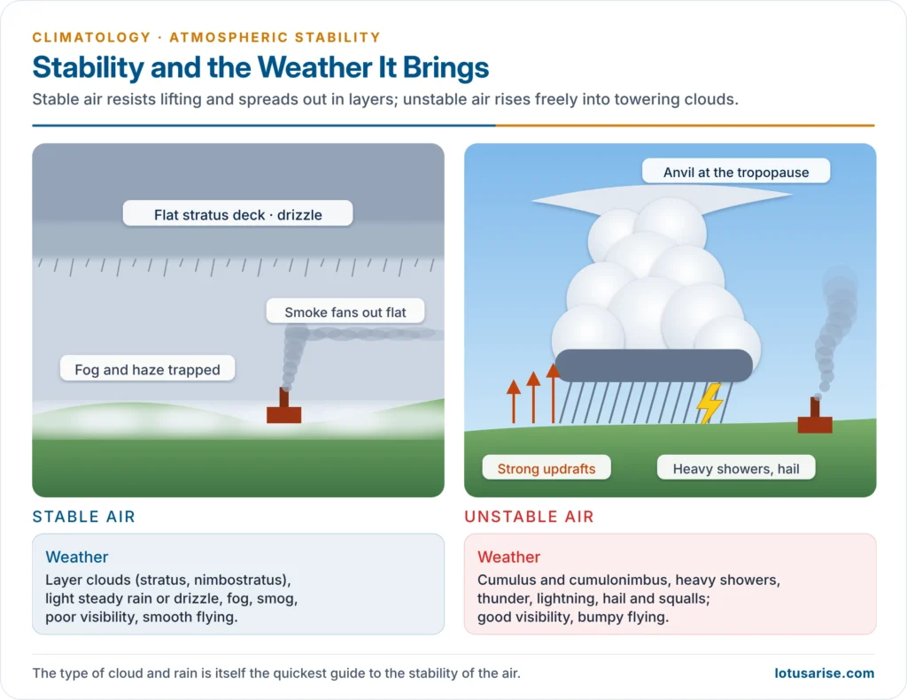
- Stable air:
- resists lifting; when forced up, it forms thin, widespread layer clouds (stratus, altostratus, nimbostratus) with light, steady rain or drizzle
- favours fog, haze and smog, because pollutants stay near the ground; smoke plumes fan out horizontally
- gives smooth flying and poor visibility
- Unstable air:
- rises freely and builds tall cumuliform clouds (cumulus, cumulonimbus) with heavy showers, thunder, lightning, hail and gusty winds
- mixes pollutants upward, so visibility is good outside the showers; smoke plumes loop up and down
- gives bumpy flying
- The kind of precipitation is itself a guide: drizzle under an overcast sky means lifted stable air; cumulonimbus showers mean unstable air.
Tropical Atmospheric Instability
- The tropical troposphere is conditionally unstable almost all year:
- warm oceans (sea-surface temperatures above about 26.5–27 °C) and strong heating keep the lower air hot and moist
- the air aloft is relatively dry and cool, so the lapse rate in the lower troposphere lies between the dry and saturated rates, and CAPE is large
- Triggers that release the instability:
- convergence in the ITCZ and the monsoon trough
- easterly waves, the Madden–Julian Oscillation and low-pressure systems
- orographic lifting (the Western Ghats, Himalaya and Arakan Yoma)
- afternoon surface heating over land
- Results:
- daily afternoon convectional rain in the equatorial belt
- deep cumulonimbus “hot towers”, which Herbert Riehl and Joanne Malkus (1958) showed carry heat and moisture to the upper troposphere and drive the Hadley circulation
- tropical cyclones, which grow only where deep conditional instability, warm seas and weak wind shear coincide
- Where it is suppressed: under the trade-wind inversion on the eastern sides of the subtropical oceans and over the west-coast deserts, where subsiding air keeps the atmosphere stable and dry.
Indian Examples
- Pre-monsoon thunderstorms (March–May):
- Over eastern and north-eastern India and Bangladesh, warm moist air from the Bay of Bengal near the surface lies under dry westerly air aloft. This is ideal convective instability, and afternoon heating releases it as violent Nor’westers (Kalbaishakhi in West Bengal).
- Andhis (dust storms) over the north-west, and mango showers in Kerala and Karnataka, come from the same afternoon instability.
- Monsoon: the moist south-west monsoon is conditionally unstable; forced ascent over the Western Ghats and the Khasi Hills (Mawsynram, Cherrapunji) releases it as very heavy orographic rain. In the Himalaya, extreme local convection produces cloudbursts.
- Winter: stable anticyclonic air over north-west India, with night-time inversions, brings clear days, dense fog and smog over the Indo-Gangetic Plain, broken only when western disturbances pass.
Previous Year Questions
2009Write short note on tropical atmospheric instability.




