

- Agro-ecology is the study of farm ecosystems and their parts, both as they work in themselves and as members of the larger ecosystem. Its practical aim is more sustainable farm ecosystems.
- An agro-ecological region (AER) is a land unit fairly uniform in soil, climate, physiography and the length of the growing period (LGP), the span of days when moisture allows crops to grow.
- India has 20 such regions and 60 sub-regions, drawn by the National Bureau of Soil Survey and Land Use Planning (NBSS&LUP).
Agro-Ecological Regions
Agro-Climatic and Agro-Ecological Zones
- The two terms are often used loosely, yet they differ. The Food and Agriculture Organization (1983) set out the distinction.
| Feature | Agro-climatic zone | Agro-ecological zone |
|---|---|---|
| Unit | Land defined by major climate | Land carved out of an agro-climatic zone |
| Built from | Bioclimate plus LGP or moisture period | The above, plus landform and soil |
| Role of landform | Not a criterion | Modifies climate and LGP |
| Tells us | The range of crops the climate allows | The crops the climate and land together allow |
| Indian scheme | 15 zones of the Planning Commission | 20 regions of NBSS&LUP |
- One agro-climatic zone can therefore hold several agro-ecological regions, according to its soils.
- Studying an agro-ecological zone means examining its climate, soil, water, flora and fauna.
Why the Regions Matter
- A systematic survey of these regions is central to planning appropriate land use.
- The framework links production problems to areas with potential for a particular genotype, which is what it takes to reach the best output of a crop or variety.
- It marks out comparable regions, so that farm technology can be generated in one and transferred to another.
- It helps to:
- Estimate the yield potential of crops and crop combinations for the future.
- Decide future crop diversification.
- Choose the best crops for a given piece of land, keeping land use optimal.
- Spread agricultural research and agro-technology.
How the Regions Were Drawn
- NBSS&LUP used the growing period as an integrated measure of effective rainfall, together with soil groups.
- Boundaries were adjusted to district lines, keeping the number of regions small.
- The FAO method of layering information on maps was followed: a soil map over a bioclimatic map, with the growing-period map added using Geographical Information System (GIS) technology.
- Agro-climatic units were first split by soil type into meso regions, and the LGP was then superimposed.
- The 20 zones were later subdivided into 60 sub-zones.
- Planning scales then step down:
| Level | Units | Soil mapped as | Scale |
|---|---|---|---|
| Agro-ecological region | 20 | Great group association | 1:7 million |
| Agro-ecological sub-region | 60 | Subgroup association | 1:1 million |
| State zones | as drawn | Soil family association | 1:250,000 |
| District units | as drawn | Soil series association | 1:50,000 |
| Watershed units | as drawn | Soil phase | 1:5,000 |
- All percentage shares below refer to India’s total geographical area of 329 m ha.
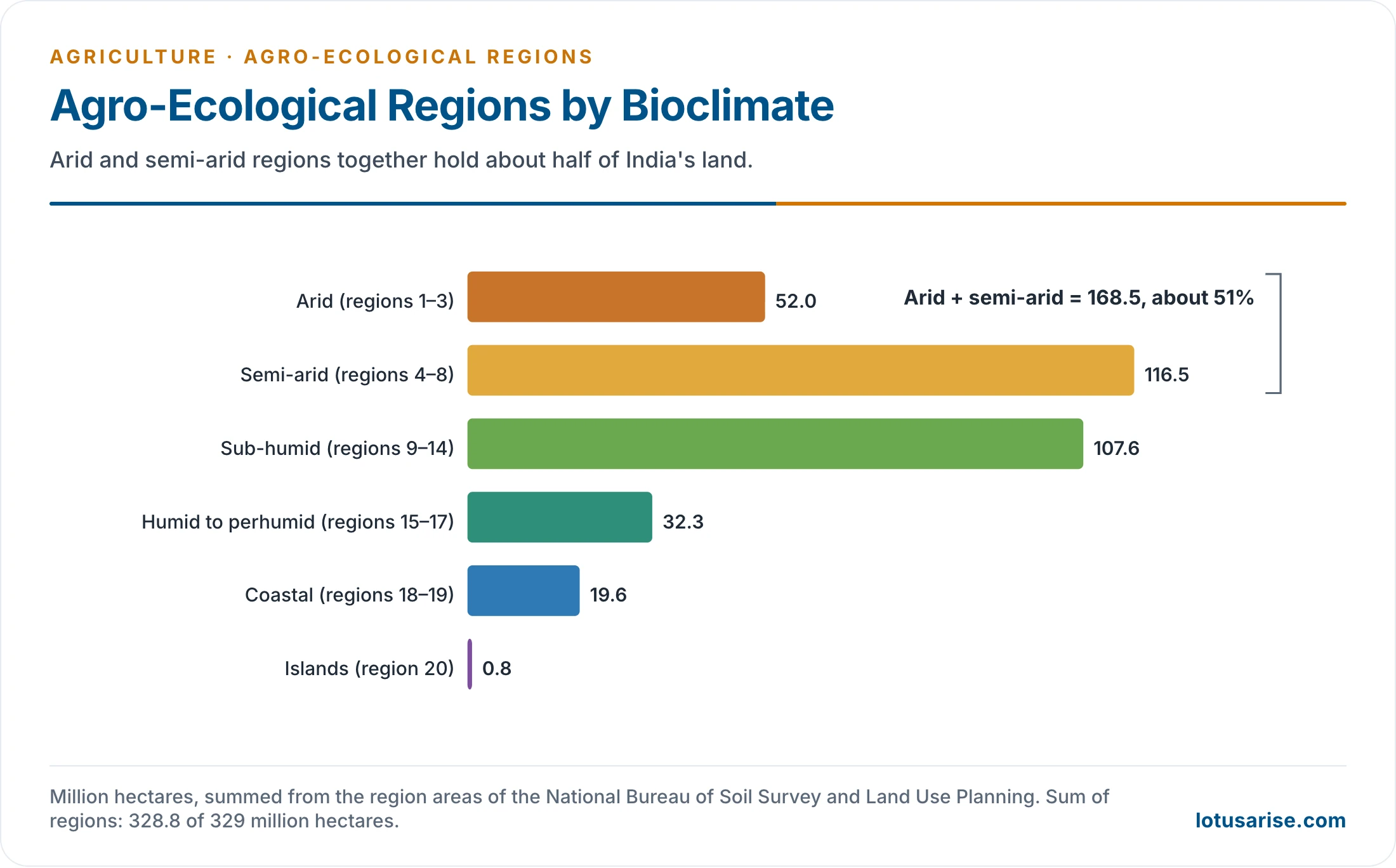
- Arid and semi-arid regions together hold about 51 per cent of the land, which explains the weight of rainfed and dryland farming in Indian planning.
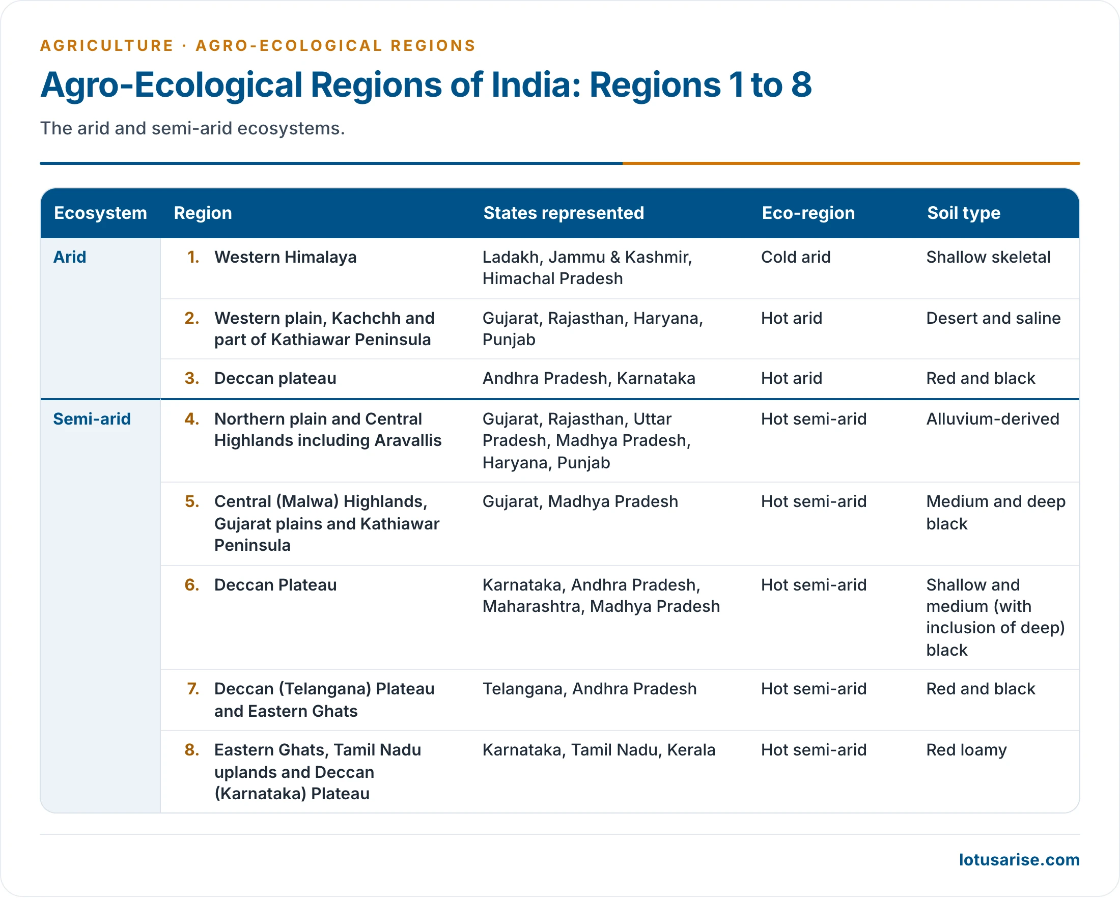
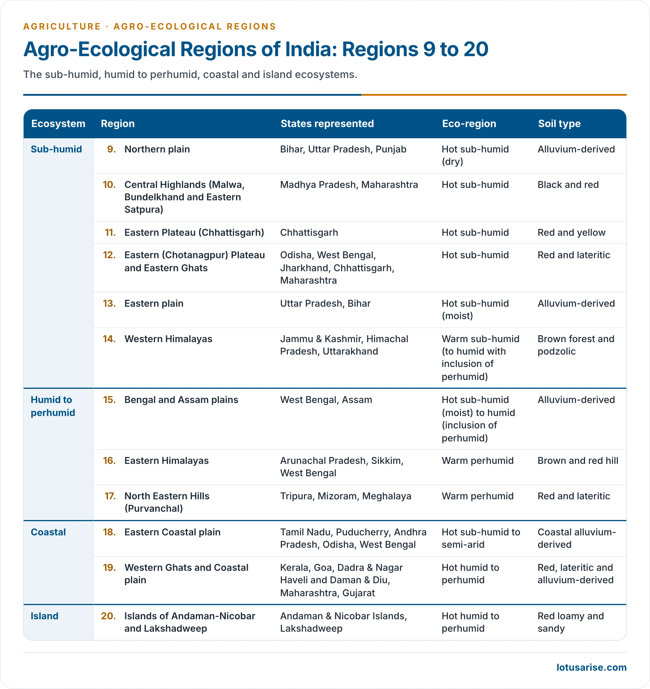
The 20 Regions
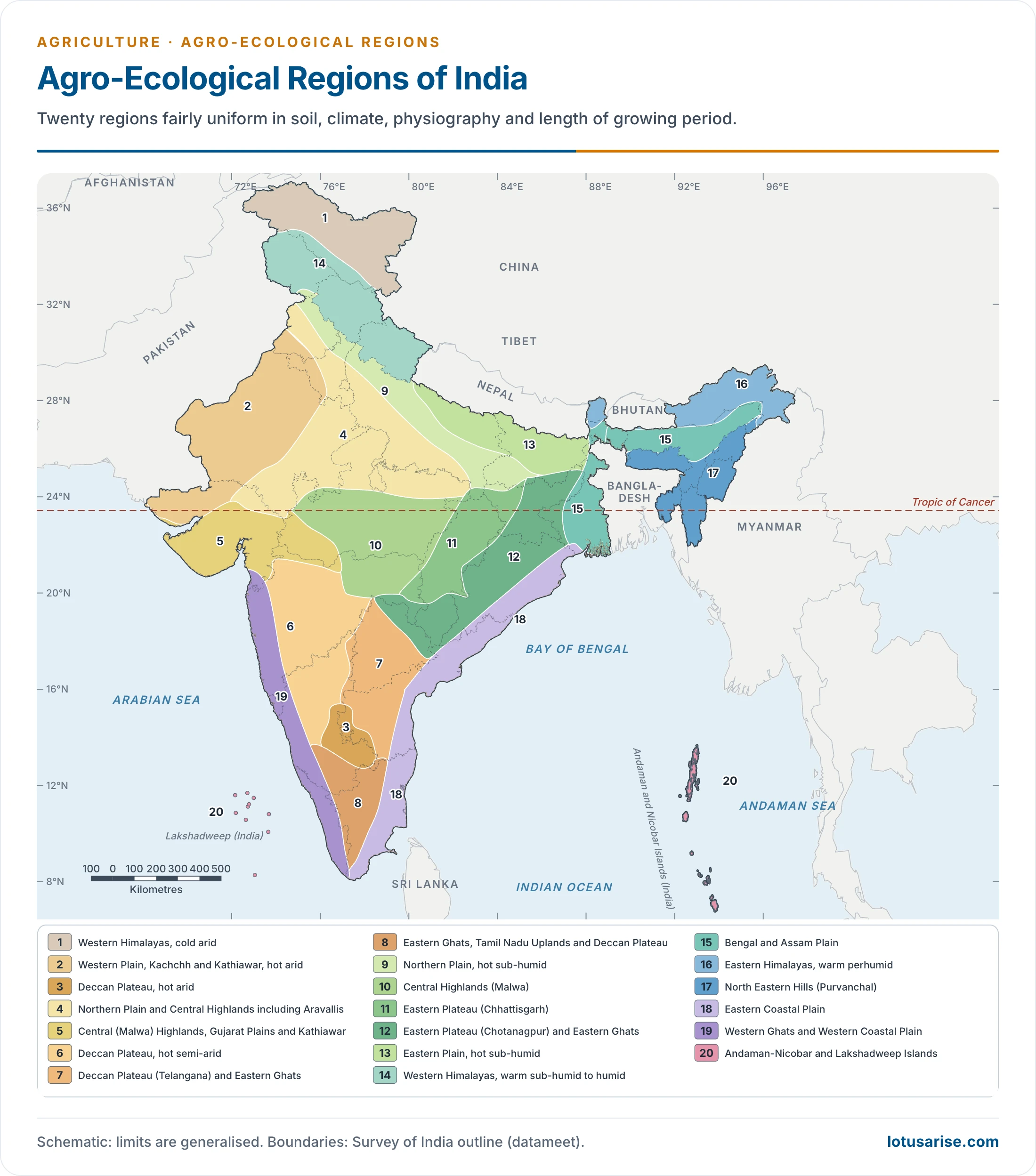
- Ladakh, a separate Union Territory, holds most of region 1.
1. Western Himalayas, Cold Arid Ecoregion
- Extent: the north-western Himalaya, covering Ladakh and Gilgit districts, over 15.2 m ha (4.7 per cent).
- Climate: mild summer and severe winter. Mean annual temperature is under 8°C and mean annual rainfall under 150 mm.
- It is a cold desert, beyond the reach of the south-west monsoon.
- The area has an aridic soil moisture regime and a cryic soil temperature regime.
- Water balance: Rain meets less than 15 per cent of the yearly demand of potential evapotranspiration (PET).
- LGP: less than 90 days a year.
- Soils: skeletal and calcareous on gently sloping to almost level valleys, alkaline, and low to medium in organic matter.
- Land use:
- The higher northern plateau stays under permanent snow, and forest trees are sparse.
- Most cultivated land grows vegetables. Apple and apricot are the main fruits.
- Among livestock the mule leads, followed by sheep, goat and yak.
- The zone is known for grazing by pashmina goats.
- Net sown area is only about 2.5 per cent, and crops such as millets, wheat, pulses and barley give low yields of 400–700 kg per hectare. Alfalfa is the main cultivated fodder.
- Constraints:
- Severe climate, above all the cryic regime, which acts as a thermal pan for plant growth.
- A narrow growing period confines farming to valleys during the thaw, which coincides with the scanty rain.
- Shallow, sandy and gravelly or bouldery soils.
- Moderately to highly calcareous soils, which upset the nutrient balance.
- Sub-regions (2):
- Eastern Ladakh plateau: cold hyper-arid, shallow skeletal soils, LGP under 60 days.
- Western Ladakh plateau and north Kashmir Himalaya: cold to cool typic-arid, shallow loamy-skeletal soils, LGP 60–90 days.
2. Western Plain, Kachchh and Part of Kathiawar Peninsula, Hot Arid Ecoregion
- Extent: south-western Punjab and Haryana, western Rajasthan, the Kachchh peninsula and northern Kathiawar in Gujarat, over 31.9 m ha (9.78 per cent).
- Climate: typical hot summer and cool winter. Mean annual precipitation is under 400 mm, with an aridic moisture and hyperthermic temperature regime.
- Jaisalmer, Barmer and Bikaner receive less than 200 mm.
- The 25 cm isohyet splits the region into the dry desert (Marusthali) and a semi-arid transitional zone.
- Water balance: Rain covers only 15–20 per cent of a PET demand of 1,500–2,000 mm, so a large deficit recurs every year.
- LGP: less than 90 days.
- Soils: sandy soils of the Thar series (Torripsamments), moderately calcareous and alkaline.
- Land use:
- Rainfed, traditional mono-cropping.
- Hardy, short-duration rainy-season crops such as pearl millet, chari (fodder) and pulses grow in non-saline areas.
- Where irrigation water is available, cotton, sugarcane, mustard, gram and wheat are grown.
- Twelve districts of western Rajasthan, surveyed from 1951–52 into the early 1970s, had about half their land lying fallow or waste.
- The Indira Gandhi Canal has brought water, along with waterlogging, salinity and alkalinity problems.
- Vegetation: sparse, sporadic tropical thorn forest. Forest area has shrunk drastically, from 15 to almost 1 per cent.
- Constraints:
- Erratic and scanty rainfall, which leaves a high water deficit.
- Soil salinity, which causes frequent physiological droughts.
- Nutrient imbalance, especially of N, P, Zn and Fe.
- Sub-regions (4):
- Marusthali: shallow and deep sandy desert soils, LGP under 60 days.
- Kachchh peninsula: deep loamy saline and alkali soil, LGP under 60 days.
- Rajasthan Bagar, north Gujarat plain and south-western Punjab plain: deep loamy desert soils, LGP 60–90 days.
- South Kachchh and north Kathiawar: deep loamy saline and alkali soils, LGP about 60 days.
3. Deccan Plateau, Hot Arid Ecoregion
- Extent: part of the Deccan plateau, in Bellary, south-western Bijapur and Raichur districts of Karnataka and Anantapur of Andhra Pradesh, over 4.9 m ha (1.5 per cent).
- Climate: hot, dry summer and mild winter. Rainfall is erratic, at 400–500 mm, because the region lies in the rain shadow of the Western Ghats. Severe drought persists almost throughout the year.
- Water balance: Rain meets 20–25 per cent of a PET demand of 1,800–1,900 mm.
- LGP: less than 90 days.
- Soils:
- Dominant: gently sloping, shallow and medium red loamy soils, slightly acidic and non-calcareous.
- Subdominant: level to very gently sloping, deep, clayey black soils, slightly alkaline and calcareous.
- Land use:
- The traditional rainfed practice leaves land fallow in the rainy season and grows crops afterwards on residual moisture.
- Some farmers risk pearl millet in the rainy season. Sorghum and safflower are the common post-rainy crops.
- Groundnut, sunflower, sugarcane and cotton are grown intensively under irrigation, where feasible. Tank irrigation supports farming on the black soils.
- Vegetation: tropical thorn forest.
- Constraints:
- High runoff and erosion during stormy cloudbursts.
- Prolonged dry spells in the growing period, with occasional crop failure.
- Subsoil sodicity in the black soils, which harms structure and drainage, and dense subsoil in the red soils, which limits rooting.
- Sub-regions (1):
- Karnataka plateau, with Rayalaseema as an inclusion.
4. Northern Plain and Central Highlands Including Aravallis, Hot Semi-Arid Ecoregion
- Extent: parts of Gujarat, the northern plains and the central highlands, over 32.3 m ha (9.8 per cent).
- Climate: hot, dry summer and cool winter. Annual precipitation is 500–1,000 mm, rising from west to east.
- Parts of Bundelkhand suffer occasional, acute drought.
- Water balance: Rain meets 35–42 per cent of a PET demand of 1,400–1,900 mm.
- LGP: 90–150 days.
- Soils: moderately to gently sloping, coarse to fine loamy soils. They are alluvium-derived on the plain, and weathered from parent rock in the highlands and the Aravallis.
- Land use:
- Almost 65 per cent is irrigated, and the rest is under traditional rainfed farming.
- On the northern plain, tube wells have overcome the droughty climate.
- Intensive kharif and rabi cropping: rice, millets, maize, pulses, berseem, wheat, mustard and sugarcane.
- Vegetation: tropical dry deciduous and thorn forests.
- Constraints:
- Coarse texture and low available water capacity (AWC).
- Over-exploitation of groundwater, with falling water tables in places.
- Imperfect drainage in places, which spreads surface and subsurface salinity.
- Sub-regions (4):
- North Punjab plain, Ganga-Yamuna doab and Rajasthan uplands: deep loamy alluvial soils, LGP 90–120 days.
- North Gujarat plain with the Aravallis and east Rajasthan uplands: deep loamy grey-brown and alluvial soils, LGP 90–120 days.
- Ganga-Yamuna doab, Rohilkhand and Avadh plain: deep loamy alluvial soils, LGP 120–150 days.
- Madhya Bharat plateau and Bundelkhand uplands: deep mixed red and black soils, LGP 90–120 days.
5. Central (Malwa) Highlands, Gujarat Plains and Kathiawar Peninsula, Hot Semi-Arid Ecoregion
- Extent: western Madhya Pradesh, south-eastern Rajasthan and Gujarat, over 17.6 m ha (5.4 per cent).
- Climate: hot, wet summer and dry winter, with annual precipitation of 500–1,000 mm.
- Water balance: Rain meets 40–50 per cent of a PET demand of 1,600–2,000 mm.
- LGP: 90–150 days.
- Soils: gently to very gently sloping deep, loamy to clayey soils, and nearly level, deep black soils. These can give high yields if water is sufficient.
- Land use:
- Dryland farming is the common practice.
- Kharif: sorghum, pearl millet, pigeonpea, groundnut, soybean, maize and pulses.
- Rabi: sorghum, safflower, sunflower and gram. Wheat is grown under irrigation.
- Vegetation: dry deciduous forest.
- Constraints:
- Intermittent dry spells.
- Salinity and alkalinity hazards under irrigation.
- Severe salinity and seasonal sea-water inundation on the Kathiawar coast, which cause crop failure.
- Sub-regions (3):
- Central Kathiawar: hot dry semi-arid, shallow and medium black soils.
- Madhya Bharat plateau, western Malwa, eastern Gujarat plain, the Vindhyan and Satpura ranges and the Narmada valley: hot moist semi-arid, deep clayey black soils.
- Coastal Kathiawar: hot moist semi-arid, deep coastal alluvium with saline patches.
6. Deccan Plateau, Hot Semi-Arid Ecoregion
- Extent: most of central and western Maharashtra, northern Karnataka and western Andhra Pradesh, over 31.0 m ha (9.5 per cent).
- Climate: hot, humid summer and mild, dry winter, with mean annual precipitation of 600–1,000 mm. It lies in the rain shadow of the Western Ghats.
- Water balance: Rain meets about 40 per cent of a PET demand of 1,600–1,800 mm.
- LGP: 90–150 days.
- Soils: loamy and clayey, chiefly shallow and medium black soils, well suited to cotton.
- Land use:
- Rainfed farming is traditional. Sorghum, pigeonpea and pearl millet are the main kharif crops.
- Cotton and groundnut are grown under irrigation.
- Vegetation: tropical dry deciduous and thorn forests.
- Constraints:
- Prolonged dry spells, with crop failure in some years.
- High runoff during stormy cloudbursts, with heavy soil loss.
- Deficiency of N, P and Zn, which upsets the nutrient balance.
- Sub-regions (4):
- South-western Maharashtra and north Karnataka plateau: hot dry semi-arid, LGP 90–120 days.
- Central and western Maharashtra, north Karnataka and north-western Telangana plateaus: hot moist semi-arid, LGP 120–150 days.
- Eastern Maharashtra plateau: hot moist semi-arid, deep clayey black soils, LGP 120–150 days.
- North Sahyadris and western Karnataka plateau: hot dry sub-humid.
7. Deccan Plateau (Telangana) and Eastern Ghats, Hot Semi-Arid Ecoregion
- Extent: the Telangana plateau and most of the Eastern Ghats of Andhra Pradesh, over 16.5 m ha (5.2 per cent). It supports red and black soils.
- Climate: hot, moist summer and mild, dry winter, with mean annual rainfall of 600–1,100 mm.
- Nalgonda, Mahbubnagar, Kurnool, Prakasam, Nellore and Cuddapah districts are recognised as drought-prone.
- LGP: 90–150 days.
- Soils:
- Black cotton soils: clayey, calcareous, strongly alkaline, with marked swell and shrink on wetting and drying. Their production potential is high.
- Red soils: non-calcareous and neutral.
- Land use:
- Rainfed farming is traditional, with irrigation where available.
- Kharif: sorghum, cotton, pigeonpea, rice, groundnut and castor. Rice is irrigated in rabi in places.
- Vegetation: tropical dry deciduous and thorn forests.
- Constraints:
- High rainy-season runoff, with severe soil and nutrient loss on both soils.
- Careless irrigation and imperfect drainage raise the water table, causing subsoil salinity and sodicity, especially on black soils.
- Deficiency of N, P and Zn.
- Frequent drought and crop failure in some years.
- Sub-regions (3):
- South Telangana plateau (Rayalaseema) and Eastern Ghats: hot dry semi-arid, LGP 90–120 days.
- North Telangana plateau: hot moist semi-arid, high AWC, LGP 120–150 days.
- Southern Eastern Ghats: hot moist semi-arid to dry sub-humid, LGP 150–180 days.
8. Eastern Ghats, Tamil Nadu Uplands and Deccan (Karnataka) Plateau, Hot Semi-Arid Ecoregion
- Extent: the Eastern Ghats, the southern Deccan plateau, the Tamil Nadu uplands and western Karnataka, over 19.1 m ha (5.8 per cent). Red loamy soils prevail.
- Climate: hot, dry summer and mild winter, with 600–1,000 mm of annual rain.
- The western parts, in Karnataka, get about 70 per cent of it in June to September.
- The eastern parts get their rain in October to December.
- LGP: 90–150 days.
- Land use:
- Rainfed farming is traditional, and tanks support agriculture.
- Kharif: millets, pulses and groundnut. Rabi: sorghum and safflower.
- Rice grows under irrigation, along with sugarcane and cotton at places.
- Vegetation: tropical dry deciduous and thorn forests.
- Constraints:
- High runoff and severe soil erosion.
- Deficiency of N, P and Zn.
- Sub-regions (3):
- Tamil Nadu uplands and the leeward flanks of the south Sahyadris: hot dry semi-arid, mixed red and black soils, LGP 90–120 days.
- Central Karnataka plateau: hot moist semi-arid, red loamy soils, LGP 120–150 days.
- Tamil Nadu uplands and plains: hot moist semi-arid, deep red loamy soils, LGP 120–150 days.
9. Northern Plain, Hot Sub-Humid (Dry) Ecoregion
- Extent: part of the northern Indo-Gangetic Plain, including the piedmont plain of the western Himalaya, over 12.1 m ha (3.7 per cent).
- Climate: hot summer and cool winter, with 1,000–1,200 mm of annual rain, 70 per cent of it in July to September.
- Water balance: Rain meets about 70 per cent of a PET demand of 1,400–1,800 mm.
- LGP: 150–180 days.
- Soils: generally deep and loamy, developed on alluvium.
- Land use:
- Rainfed and irrigated farming are both common. Wheat dominates the west and rice the east.
- Kharif: rice, maize, barley, pigeonpea and jute. Rabi: wheat, mustard and lentil.
- Sugarcane and cotton are irrigated at places.
- Vegetation: tropical dry deciduous forests.
- Constraint: careless irrigation may bring waterlogging and salinity.
- Sub-regions (2):
- Punjab and Rohilkhand plains: deep alluvial soils, LGP 120–150 days.
- Rohilkhand, Avadh and south Bihar plains: deep loamy alluvial soils, LGP 150–180 days.
10. Central Highlands (Malwa, Bundelkhand and Eastern Satpura), Hot Sub-Humid (Dry) Ecoregion
- Extent: part of the Malwa plateau and Bundelkhand uplands, with the Baghelkhand plateau, Narmada valley, Vindhyan scarplands and the northern fringe of the Maharashtra plateau, in Madhya Pradesh and Vidarbha. It covers 22.3 m ha (about 6.8 per cent), on red and black soils.
- Climate: hot summer and mild winter. Mean annual rainfall is 1,000–1,500 mm, rising eastwards.
- LGP: 150–180 days.
- Land use:
- Rainfed farming is common.
- Kharif: rice, sorghum, pigeonpea and soybean. Rabi: gram, wheat and vegetables.
- Kharif is fully rainfed. Rabi is partly irrigated at critical growth stages.
- Vegetation: tropical moist deciduous forest.
- Constraints:
- Risk of inundation in the rainy season, and of acute drought from long kharif dry spells, with crop failure at places.
- Heavy runoff and soil loss, stagnant water and poor germination.
- Deficiency of N, P and Zn.
- Sub-regions (4):
- Malwa plateau, Vindhyan scarpland and Narmada valley: hot dry sub-humid, medium and deep clayey black soils, LGP 150–180 days.
- Satpura and eastern Maharashtra plateau: hot dry sub-humid, shallow and medium black soils, LGP 150–180 days.
- Vindhyan scarpland and Bundelkhand plateau: hot dry sub-humid, deep mixed red and black soils.
- Satpura range and Wainganga valley: hot moist sub-humid, mixed red and black soils, LGP 180–210 days.
11. Eastern Plateau (Chhattisgarh/Mahanadi Basin), Hot Sub-Humid Ecoregion
- Extent: the eastern plateau, covering the Chhattisgarh region and the south-western highlands of the former Bihar, now Jharkhand, over 14.1 m ha (4.3 per cent). Soils are red and yellow.
- Climate: hot summer and cool winter, with 1,200–1,600 mm of rain, 70–80 per cent of it in July to September.
- Water balance: Rain meets about 60 per cent of a PET demand of 1,400–1,500 mm.
- LGP: 150–180 days.
- Land use:
- Traditional rainfed farming of rice, millets, pigeonpea, moong (green gram) and blackgram (urad) in kharif. Intensive rice growing has earned the tract the name rice bowl of India.
- Wheat and rice are irrigated in rabi at places.
- Vegetation: tropical moist deciduous forest.
- Constraints:
- Soils prone to severe water erosion.
- Partial waterlogging early in crop growth, and seasonal drought later.
- Deficiency of N, P and micronutrients such as Zn and B.
- Sub-regions (1):
- Moderately to gently sloping Chhattisgarh and Mahanadi basin.
12. Eastern Plateau (Chotanagpur) and Eastern Ghats, Hot Sub-Humid Ecoregion
- Extent: the Chotanagpur plateau of Jharkhand (then part of Bihar), western West Bengal, the Eastern Ghats (Dandakaranya and Garhjat hills) of Odisha and the Bastar region of Chhattisgarh, over 26.8 m ha (8.2 per cent).
- Climate: hot summer and cool winter, with 1,000–1,600 mm of annual rain.
- Water balance: Rain meets about 80 per cent of PET demand.
- LGP: 150–180 days, and 180–210 days at places.
- Soils: fine loamy to clayey, non-calcareous, slightly to moderately acidic, with relatively low cation exchange capacity.
- Shallow on ridges and plateaus, and under forest.
- Deep in valleys, and generally cultivated.
- Land use:
- Rainfed rice, pulses (moong, blackgram and pigeonpea) and groundnut.
- Rabi rice (at places) and wheat, mostly irrigated.
- Vegetation: tropical dry and moist deciduous forests.
- Constraints:
- Severe erosion hazard.
- Seasonal drought, which limits yields.
- Deficiency of N, P and micronutrients such as Zn and B.
- Sub-regions (3):
- Garhjat hills, Dandakaranya and Eastern Ghats: hot moist sub-humid, deep red and lateritic soils, LGP 180–210 days.
- Eastern Ghats: hot moist sub-humid, medium to deep red and lateritic soils, LGP 180–210 days.
- Chotanagpur plateau and Garhjat hills: hot dry sub-humid, LGP 150–180 days.
13. Eastern Plain, Hot Sub-Humid (Moist) Ecoregion
- Extent: north-eastern Uttar Pradesh and northern Bihar, including the foothills of the Central Himalaya, with the Bhabar and Tarai to the north, over 11.1 m ha (3.4 per cent).
- Climate: hot, wet summer and cool, dry winter, with 1,400–1,800 mm of annual rain.
- Water balance: Rainfall stands above a PET demand of 1,300–1,500 mm, with only a small seasonal deficit from February to May.
- LGP: 180–210 days, long enough for two crops a year.
- Soils: level to very gently sloping, alluvium-derived, laid down by perennial Himalayan rivers.
- Land use:
- Rainfed kharif: rice, maize, pigeonpea and moong.
- Post-rainy (rabi): wheat, lentil, pea, sesamum and, at places, groundnut, on residual moisture with one or two protective irrigations at critical stages.
- Cash crops with supplemental irrigation: sugarcane, tobacco, chillies, turmeric, coriander and potato.
- Vegetation: tropical moist deciduous and dry deciduous forests.
- Constraints:
- Flooding and imperfect drainage, which limit soil aeration.
- Patches of salinity or sodicity, which hurt yields.
- Deficiency of N, P and Zn.
- Sub-regions (2):
- North Bihar and Avadh plains: hot, dry to moist sub-humid transition, deep loamy alluvial soils.
- Foothills of the Central Himalaya: warm to hot moist sub-humid, deep Tarai soils, high AWC.
14. Western Himalayas, Warm Sub-Humid (to Humid with Inclusion of Perhumid) Ecoregion
- Extent: Jammu and Kashmir, Himachal Pradesh and Uttarakhand (then the north-western hills of Uttar Pradesh), over 21.2 m ha (6.3 per cent).
- Climate: warm sub-humid to cool humid, with perhumid pockets. Summer is mild and winter cold.
- Rainfall is generally 1,000–2,000 mm, and exceeds 2,000 mm in parts of Himachal Pradesh and Uttarakhand.
- Water balance: PET demand is low, so precipitation exceeds it in most months.
- LGP: 180–210 days.
- Soils: shallow to deep, medium-textured, high in organic matter, with weak to well-developed horizons. They are classed as brown forest and podzolic soils.
- Land use:
- Rainfed farming in valleys and on terraces, of wheat, millet, maize and rice.
- Terraced uplands carry paddy or horticultural plantations such as apple. Rugged relief holds back field crops, but temperate fruit thrives.
- Vegetation: Himalayan moist temperate, subtropical pine and sub-alpine forests.
- Constraints:
- Severe cryic or frigid climate at high northern altitudes, which limits the choice of crops.
- Deforestation and steep slopes, which favour erosion.
- Soil degradation and common landslides.
- Soil acidity, especially around Kangra and Manali.
- Sub-regions (5):
- South Kashmir and Punjab Himalaya: cold and warm, dry to sub-humid, LGP 90–120 days.
- South Kashmir and Kumaon Himalaya: warm, moist to dry sub-humid, LGP 150–210 days.
- Punjab Himalaya: warm, humid to perhumid, LGP 270–300 days or more.
- Kumaon hills: warm, humid to perhumid, red and yellow soils, LGP 270–300 days or more.
- Foothills of the Kumaon Himalaya: warm moist sub-humid, Tarai soils, LGP 270–300 days.
15. Bengal and Assam Plain, Hot Sub-Humid to Humid (Inclusion of Perhumid) Ecoregion
- Extent: the plains of the Brahmaputra and the Ganga, in parts of Assam and West Bengal, over 12.1 m ha (3.7 per cent).
- Climate: hot summer and mild to moderately cool winter. Precipitation is heavier in the northern and eastern parts (the Bengal basin and Teesta-Brahmaputra plain) than in the south (Ganga plain).
- Ganga plain: 1,400–1,600 mm.
- Barak basin (Tripura plain) and Teesta-Brahmaputra plains: 1,800–2,000 mm.
- LGP: generally more than 210 days. Older accounts give 180–210 days.
- Soils: rich alluvium-derived soils.
- Land use:
- Rice-based cropping dominates the Brahmaputra, Teesta and Ganga plains. Rice and jute are the main rainy-season crops, grown rainfed. The Ganga-Brahmaputra delta is known for jute.
- In the northern foothills of the eastern Himalaya, across the Teesta and Brahmaputra tracts, tea plantations and horticultural crops such as pineapple, citrus and banana are grown.
- Vegetation: tropical moist and dry deciduous forests.
- Constraints:
- Flooding and waterlogging.
- Excessive leaching of bases and nutrients, which leaves low-base soils, especially in the Brahmaputra (Assam) plain.
- Sub-regions (4):
- Bengal basin and north Bihar plain: hot moist sub-humid, LGP 210–240 days.
- Middle Brahmaputra plain: hot humid, LGP 240–270 days.
- Teesta, lower Brahmaputra plain and Barak valley: hot, moist humid to perhumid, LGP 270–300 days.
- Upper Brahmaputra plain: warm to hot perhumid, LGP about 300 days.
16. Eastern Himalayas, Warm Perhumid Ecoregion
- Extent: northern hilly West Bengal, northern Assam, Arunachal Pradesh and Sikkim, over 9.6 m ha (2.9 per cent).
- Climate: warm summer and cool winter, with about 2,000 mm of annual rain and more in places. A short period of water stress follows the rains.
- LGP: the water balance gives the longest growing period, more than 270 days.
- Soils: from shallow to moderately shallow, loamy brown forest soils to deep, organic-rich soils, with moderate to low base status.
- Land use:
- Jhum (shifting cultivation) is the traditional practice, with mixed cropping on steep rainfed slopes at intervals of 3–4 years.
- Millets on upland terraces, and potato, maize, millets and paddy in valleys.
- In the hills: vegetables, plantation crops such as tea, medicinal plants, and horticultural crops such as pineapple, citrus, apple, pear, peach and banana on terraces.
- Vegetation: subtropical pine, temperate wet evergreen and subalpine forests.
- Constraints:
- Steep slopes, heavy runoff and severe erosion.
- Deforestation for shifting cultivation, with severe soil degradation.
- High rainfall and intense leaching, which leave poor-base soils.
- Excess moisture and stagnant water in valleys around the monsoon, which limit crop choice.
- Low post-monsoon temperature, which rules out a second crop, so monocropping is common.
- Sub-regions (3):
- Foothills of the Eastern Himalaya (Bhutan foothills): skeletal to loamy Tarai soils.
- Darjeeling and Sikkim Himalaya: shallow to medium loamy brown and red hill soils.
- Arunachal Pradesh (subdued Eastern Himalaya): deep red loamy soils.
17. North-Eastern Hills (Purvanchal), Warm Perhumid Ecoregion
- Extent: the hilly States of Nagaland, Meghalaya, Manipur and Mizoram, and southern Tripura, over 10.6 m ha (3.3 per cent).
- Climate: warm summer and cool winter, with annual precipitation of 2,000–3,000 mm.
- Water balance: Rainfall stays mostly above PET.
- LGP: over 270 days.
- Soils: shallow to very deep, loamy, red and lateritic, and red and yellow soils. They give little support to farming, and forests cover most of the land.
- Land use:
- Jhum is the traditional farming.
- Rice dominates valleys and hill terraces. Millets, maize and potatoes are grown on higher terraces.
- Rice and jute are also grown rainfed in small valley patches.
- Hill terraces also carry plantations (tea, coffee, rubber) and fruits (oranges, pineapple and others).
- Vegetation: wet evergreen and tropical moist deciduous forests.
- Constraints:
- Deforestation and shifting cultivation, with severe erosion.
- Excess rainfall and leaching, with poor-base soils.
- Small and marginal holdings, which limit modern implements.
- Sub-regions (2):
- Meghalaya plateau and Nagaland hills: red and lateritic soils, LGP 270–300 days or more.
- Purvanchal (eastern range): deep red and yellow soils, LGP about 300 days.
18. Eastern Coastal Plain, Hot Sub-Humid to Semi-Arid Ecoregion
- Extent: the south-eastern coastal plain from Kanniyakumari to the Gangetic delta, over 8.5 m ha (2.6 per cent).
- Climate: a wide range, so two rainfall belts are separated.
| Belt | Rain (mm) | Season | LGP (days) | Climate |
|---|---|---|---|---|
| Kanniyakumari to south of Thanjavur; north of Chennai to West Godavari | 900–1,100 | about 80 per cent in October–December | 90–150 | Semi-arid |
| Nagapattinam to Chennai; north-western coastal strip through Godavari, Odisha and West Bengal | 1,200–1,600 | 80 per cent in June–September | 150–210 or more | Sub-humid (moist) |
- Bioclimate thus runs from semi-arid to sub-humid, and the LGP from 90 to 210 days.
- The strip is grouped as one unit because of its maritime climate and limited area.
- Land use:
- Rainfed and irrigated farming are both practised.
- Rice leads in kharif and rabi, on the fertile alluvium of the Mahanadi, Godavari, Krishna and Kaveri deltas. Coconut is the dominant plantation crop.
- Pulses (blackgram, lentil) and oilseeds (sunflower, groundnut) follow rice in some parts.
- Coastal and brackish-water fisheries are important too.
- Constraints:
- Salinity (and sodicity at places) from poor drainage.
- Cyclones in the monsoon and retreating-monsoon periods.
- Sub-regions (5):
- South Tamil Nadu coast: hot dry semi-arid, LGP 90–120 days.
- North Tamil Nadu coastal plains: hot moist semi-arid, high AWC, LGP 120–150 days.
- Andhra plain: hot dry sub-humid, LGP 150–180 days.
- Utkal plain and East Godavari delta: hot dry sub-humid, LGP 180–210 days.
- Gangetic delta: hot moist sub-humid to humid, LGP 240–270 days.
19. Western Ghats and Coastal Plain, Hot Humid-Perhumid Ecoregion
- Extent: the Sahyadris, the coastal plains of Maharashtra, Karnataka and Keralam (Kerala), and the Nilgiri hills of Tamil Nadu, over 11.1 m ha (3.6 per cent).
- Climate: hot, humid summer and warm winter. Mean annual temperature is 25–28°C, and mean annual rainfall exceeds 2,000 mm in most areas.
- LGP: 150–210 days, exceeding 210 at places.
- Soils: red and lateritic along the leeward flank of the Sahyadris, and alluvium-derived in the coastal plains.
- Land use: intensive cultivation of rice, tapioca, coconut and spices.
- Vegetation: tropical moist deciduous forests.
- Constraints:
- Excessive leaching, which depletes plant nutrients and bases.
- Waterlogging from imperfect drainage on the coastal plains.
- Steep slopes, with runoff and severe erosion.
- Inundation, which forms localised saline marshes.
- Sub-regions (3):
- North Sahyadris and Konkan coast: hot humid, mixed red and black soils, LGP 210–240 days.
- Central and south Sahyadris: hot, moist sub-humid to humid, red and lateritic soils, LGP 210–270 days.
- Konkan, Karnataka and Keralam coastal plain: hot, humid to perhumid, acidic coastal alluvium, LGP 240–270 days.
20. Islands of Andaman-Nicobar and Lakshadweep, Hot Humid to Perhumid Island Ecoregion
- Extent: the Andaman and Nicobar group in the east and Lakshadweep in the west, over 0.8 m ha (0.3 per cent).
- Climate: tropical, with little difference between mean summer and winter temperatures.
- Annual rainfall varies from 1,600 to 3,000 mm: 1,600 mm in Lakshadweep (humid) and 3,000 mm in the Andaman-Nicobar group (perhumid).
- LGP: more than 210 days, which supports double cropping and plantations.
- Soils:
- Andaman and Nicobar: medium to very deep red loamy soils, with marine alluvium along the coast.
- Lakshadweep: highly calcareous and sandy.
- Vegetation: tropical rain (evergreen), littoral and swamp forests. About two-thirds of the Andaman stays under native forest.
- Land use:
- Farming is confined to areas around habitations, where rice dominates.
- Plantations lead overall: coconut, arecanut and oil palm, with or without pineapple, tapioca and pepper as intercrops.
- In Lakshadweep, rice grows under lowland conditions, and high-yielding coconut is the main plantation crop.
- Marine fishery is an important means of subsistence.
- Constraints:
- Degradation of the rain forest. Clearing disturbs the ecosystem and causes severe erosion.
- Coastal inundation, which forms saline marshes and acid sulphate soils.
- A gradual increase in mangrove area, which suggests growing degradation of coastal land.
- Sub-regions (2):
- Andaman and Nicobar group: hot perhumid, red and yellow and red loamy soils, LGP about 300 days.
- Lakshadweep group: hot humid, loamy to sandy and littoral soils, LGP 240–270 days.
Reading the Regions Together
- Moisture sets the sequence. The growing period lengthens as the bioclimate gets wetter, and this drives the choice of cropping:
- Arid: under 90 days, so one short rainfed crop or none without irrigation.
- Semi-arid: 90–150 days, so a single rainfed crop in most years, and dryland farming.
- Sub-humid: 150–210 days, so a long kharif, with rabi on residual moisture or irrigation.
- Humid to perhumid: over 210 days, so double cropping and plantations where the land allows.
- Soil splits the same climate. The hot semi-arid belt alone forms five regions, separated by alluvium, black, red and black, and red loamy soils. This is the gain over a purely climatic division.
- Regions broadly match the 15 agro-climatic zones as follows, though boundaries cut across each other:
- Western Himalayan zone: regions 1 and 14. Eastern Himalayan zone: regions 16 and 17.
- Trans-Gangetic and Upper Gangetic zones: regions 2 (south-west), 4 and 9.
- Middle Gangetic zone: regions 13 and 9. Lower Gangetic zone: region 15.
- Eastern Plateau zone: regions 11 and 12. Central Plateau zone: regions 4, 5 and 10.
- Western Plateau zone: regions 5 and 6. Southern Plateau zone: regions 3, 6, 7 and 8.
- East Coast zone: region 18. West Coast zone: region 19.
- Gujarat zone: regions 2 and 5. Western Dry zone: region 2. Islands zone: region 20.
- Recurring constraints follow from the same logic:
- Dry regions suffer from deficit water, salinity and drought.
- Black and red soil plateaus suffer from runoff, erosion and shortage of N, P and Zn.
- Alluvial plains suffer from waterlogging, flooding and salinity under irrigation, along with falling groundwater in the north-west.
- Wet hills and coasts suffer from leaching, erosion and shifting cultivation.





Good notes
Thanks a lot
Good notes
Very nice compilation of the AER
Very precise notes. Agri students also can refer such a note on Agronomy
Under the sub-humid ecosystem, in the Eastern (Chhota Nagpur) Plateau and Eastern Ghats Agro-Ecological Zone you have mentioned all the states surrounding Jharkhand, but not Jharkhand even though the majority of the Chhota Nagpur Plateau lies in Jharkhand. Please include/update it. Other than that, a very good tabular form for the agro-ecological zones of India.