

Impact of Pleistocene Ice Age on the crust of the Earth. (2013)
- The Pleistocene (about 2.58 million to 11,700 years ago) brought repeated advances of continental ice; at the Last Glacial Maximum, about 26,000–20,000 years ago, ice covered roughly a quarter of the land surface (about a tenth today) and reached about 3 km in thickness over Canada and Scandinavia.
- This vast load, and its removal, acted on the crust in four linked ways: glacio-isostatic depression and rebound, glacio-eustatic sea-level change, altered crustal stress and faulting, and changed volcanism.
Depression Under the Ice Load
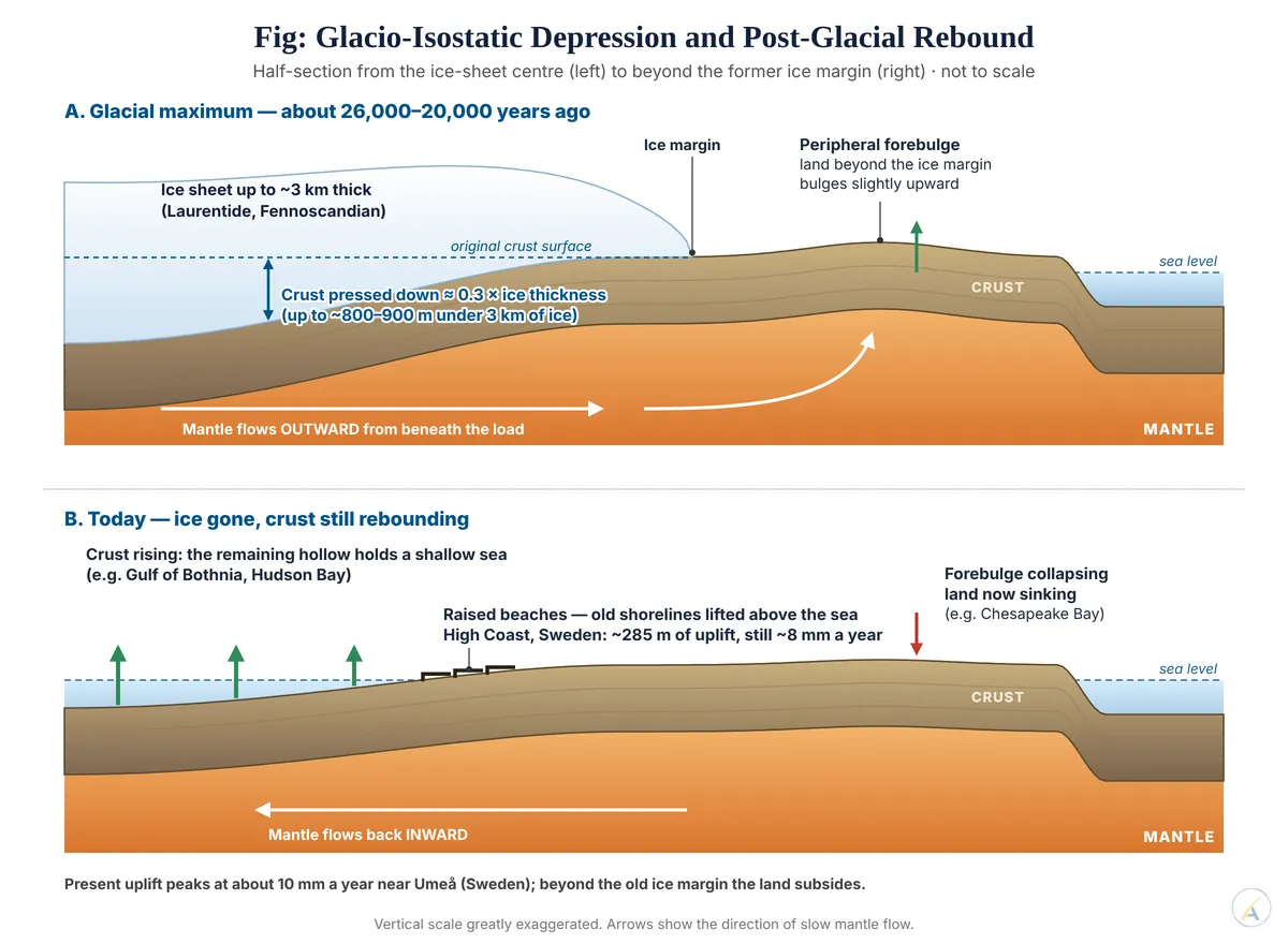
- By isostasy, the loaded crust sank into the mantle until the displaced mantle balanced the ice; depression is roughly the ice thickness × the ratio of ice to mantle density (about 0.3) — up to some 800–900 m beneath 3 km of ice.
- The displaced mantle flowed outward, raising a low peripheral forebulge beyond the ice margin.
- The main centres were Hudson Bay (Laurentide ice sheet) and the Gulf of Bothnia (Fennoscandian ice sheet).
Post-Glacial Rebound: Still Under Way
- Unloading caused a quick elastic rise, followed by a slow viscous recovery as mantle flowed back — slow because mantle viscosity is extremely high.
- The High Coast of Sweden, on the Gulf of Bothnia, has risen about 285 m since deglaciation — the highest known isostatic rebound — and is still rising about 8 mm a year; its raised beaches form a staircase of former shorelines.
- Olav Vestøl and colleagues’ NKG2016LU land-uplift model (2019) shows a present maximum of 10.3 mm a year near Umeå, falling to zero along the German and Polish coasts.
- Hudson Bay is rising at about 1 cm a year on GPS measurements; the Kvarken strait is expected to close the Gulf of Bothnia in over 2,000 years.
- Forebulge collapse: beyond the old ice margins the land is now sinking — the Chesapeake Bay region of the United States and the Netherlands — adding to their relative sea-level rise.
Glacio-Eustasy: The Ocean Side of the Load
- Water locked in ice lowered global sea level by about 120–125 m, exposing continental shelves as land bridges — Beringia, Sundaland, and India joined to Sri Lanka across the Palk Strait.
- Rivers cut down to the lowered base level; the post-glacial rise then drowned these valleys as rias and estuaries.
- Hydro-isostasy: returning meltwater in turn loaded and depressed the continental shelves.
- Relative sea level is the sum of eustasy and isostasy: Scandinavian coasts are emerging while the southern North Sea coasts were drowned.
- Jerry Mitrovica and Glenn Milne (2002) showed through ocean siphoning and continental levering that these effects reach far-field coasts, including the tropics, long after the ice has gone.
Stress, Faults and Volcanoes
- A thick ice load clamps faults; rapid unloading released the stored stress.
- In Lapland, large post-glacial faults ruptured as the ice vanished about 10,000 years ago — the Pärvie fault, about 155 km long, is the longest known.
- Rebound stress still contributes to intraplate earthquakes in eastern Canada and northern Europe.
- In Iceland, unloading lowered pressure on the mantle and eruption rates rose many times over for over a thousand years after deglaciation.
- Redistributing so much mass also altered the Earth’s gravity field and rotation, now tracked by satellite gravimetry (GRACE).
Significance
- Judgement: the Pleistocene ice ages were the planet’s largest natural loading experiment — they proved that the crust floats on a viscous mantle, and their crustal effects are unfinished: Scandinavia and Canada still rise, forebulge coasts still sink, and every modern sea-level estimate from tide gauges or satellites must first remove this glacial isostatic adjustment.