

Question: Write a short note on hydrology of limestone terrain.
Introduction: The Soluble Rock Paradigm
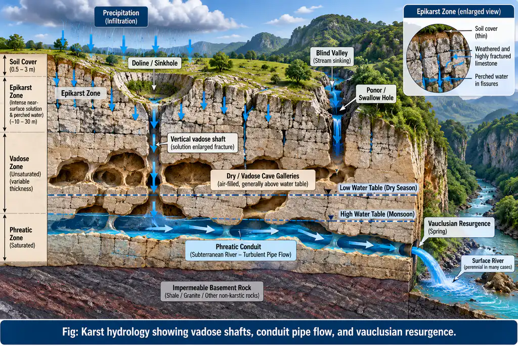
The hydrology of limestone terrain (karst hydrology) is fundamentally governed by the chemical solubility of calcium carbonate (CaCO3 + H2O + CO2 ⇌ Ca(HCO3)2) in meteoric water enriched with biogenic soil carbon dioxide. Unlike clastic sedimentary rocks where fluid moves through intergranular pore spaces (primary porosity), limestone formations are dominated by secondary porosity and fracture permeability enlarged by chemical solution (speleogenesis). This produces an intricate subterranean drainage network operating under dynamic, anisotropic hydrological laws.
1. Distinctive Hydrological Characteristics of Karst
A. Dual Flow Mechanism (Diffuse vs. Conduit Flow)
- Diffuse (Slow) Matrix Flow: Water percolates slowly through tight microscopic joints and intergranular pores, providing long residence times (months to years) and steady baseflow.
- Conduit (Fast) Pipe Flow: Solutionally enlarged fissures, shafts, and master caverns act as subterranean superhighways where groundwater flows turbulently at velocities exceeding 0.1 to 5 km/day, comparable to subaerial mountain torrents.
B. Surface Drainage Deficiency and Subterranean Capture
- Absence of Perennial Streams: Precipitation rapidly disappears underground through sinkholes (dolines) and swallow holes (ponors).
- Disrupted Drainage Geometry: Valleys terminate abruptly as blind valleys (where a river plunges into a cave entrance) or remain abandoned as dry valleys when subterranean piracy captures the surface discharge.
- Divergent Catchments: Surface topographic divides do not coincide with phreatic groundwater divides; subterranean conduit piracy frequently routes groundwater across continental surface watersheds.
C. The Epikarst and Fluctuation of the Karst Water Table
- Epikarst Zone: The intensely weathered, fractured uppermost 3–15 meters of limestone immediately beneath the soil functions as a temporary perched aquifer that stores rainwater and slowly meters it into deeper vertical shafts.
- Highly Volatile Phreatic Surface: Because of low storage capacity in dense rock mass and rapid conduit drainage, the karst water table exhibits extreme seasonal fluctuations (oscillating vertically by 20 to 80 meters between dry season baseflow and monsoon storm events).
D. Karst Springs and Resurgences
Groundwater re-emerges along geological boundaries or canyon incisions:
- Vauclusian Springs (Exsurgences): Powerful springs emerging from deep, drowned subterranean conduits under hydrostatic head (e.g., Fontaine de Vaucluse, France).
- Indian Manifestations: The expansive karst terrains of the Jaintia and Khasi Hills of Meghalaya (hosting the Krem Liat Prah cave system > 31 km long and Mawsmai caves) discharge massive subterranean torrents; the Borra Caves (Vishakhapatnam, Andhra Pradesh) along the Gosthani River basin; and the Gupteswar caves in Odisha.
2. Environmental and Water Management Vulnerabilities
- High Contamination Vulnerability: The absence of a thick, continuous soil cover and the rapid transit velocity through conduits mean that limestone aquifers lack natural mechanical filtration or biological attenuation. Pathogens, agrochemicals, and industrial effluents introduced into a single sinkhole can contaminate regional municipal drinking water wells miles away within hours.
- Extreme Hydrological Flashiness: Karst springs exhibit flashy, spike-like hydrographs during storm events followed by rapid depletion, necessitating sophisticated hydrochemical tracer studies (fluorescent dye tracing) and karst aquifer vulnerability mapping (e.g., EPIK method).
Conclusion
Understanding limestone hydrology is vital for geo-environmental planning. Sustainable development in karst regions (such as Meghalaya and Bastar) requires delineated groundwater protection perimeters around sinking zones, real-time dye tracing, and integrated catchment-cave system conservation.