

Question: Write a short note on geomorphology & waste management.
Introduction: Geomorphology as the Primary Containment Barrier
In environmental management, the disposal of solid, hazardous, and radioactive wastes requires long-term isolation from the biosphere and hydrological cycle. Applied environmental geomorphology serves as the first scientific filter in waste management. Engineering liners and membranes have finite lifespans (decades to centuries); long-term containment integrity relies on terrain stability, lithological impermeability, vadose zone thickness, and slope kinematics.
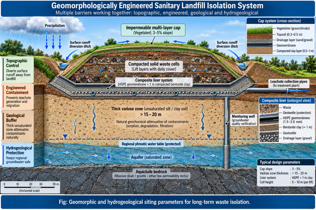
1. Near-Surface Municipal Solid Waste (MSW) Sanitary Landfills
The selection, operation, and closure of engineered landfills depend directly on geomorphological and hydrogeological parameters:
- Topographic Slope and Relief: Ideal landfill terrain features gentle, undulating slopes of 2° to 6°. Slopes below 2° cause surface water ponding and accelerated infiltration, generating excessive toxic leachate; slopes steeper than 10° induce mass wasting, slope failure, and erosion of capping liners.
- Vadose Zone Thickness and Groundwater Protection: The base of the landfill must maintain a thick unsaturated vadose zone (> 15–20 meters above the seasonal peak water table) underlain by natural aquitards or aquicludes (impermeable clay, unjointed mudstone, or thick shale with hydraulic conductivity K < 10⁻⁷ cm/s) to retard leachate migration.
- Avoidance of Geomorphological Vulnerability Zones:
- Floodplains and Meander Belts: Siting within 100-year flood lines leads to periodic inundation and catastrophic contaminant dispersion into river networks.
- Karst Terrains and Fractured Bedrock: Karst solution pipes and tectonic fault zones transmit raw leachate directly into regional drinking water aquifers within hours.
- Coastal Wetlands and Estuaries: High water tables and tidal oscillations cause rapid geochemical dispersion.
- Indian Legacy Dump Hazards: Unscientific, terrain-blind dumping at Ghazipur and Bhalswa (Delhi) and Deonar (Mumbai)—exceeding heights of 65 meters on alluvial floodplains and coastal mudflats—has caused recurring slope collapses, methane explosions, and unmitigated toxic leachate discharge into the Yamuna River and Thane Creek.
2. Deep Geological Repositories (DGR) for Hazardous and Nuclear Waste
For high-level radioactive waste (HLW) with isolation horizons spanning 10⁴ to 10⁶ years, geomorphology evaluates deep structural and tectonic security:
- Tectonically Stable Cratonic Shields: Repositories are excavated 400–1,000 meters deep within crystalline, fracture-poor plutonic rocks (granite, granodiorite, gneiss) or massive argillaceous shale formations.
- Absence of Active Neotectonics: Sites must be devoid of active fault slip, seismic reactivation, volcanic hazards, or rapid exhumation/uplift rates.
- Global & Indian Benchmarks: The world-leading Onkalo Repository (Olkiluoto, Finland) excavated in the stable Fennoscandian crystalline shield, Sweden’s Forsmark, and India’s Bhabha Atomic Research Centre (BARC) investigations into deep, stable granitic formations in the Archaean Dharwar and Bundelkhand cratons.
3. Geomorphic Reclamation of Mining Tailings and Landfills
- Geomorphic Landform Design: Replacing planar, artificial landfill/tailing terraces with natural compound concave-convex slopes that match local mature drainage patterns. This eliminates rill-and-gully erosion and prevents catastrophic tailings dam breaches (e.g., preventing Singrauli fly-ash dyke breaches or Bailadila iron-ore slimes landslides).
Conclusion
Engineering interventions cannot compensate for poor terrain selection. Modern waste governance requires strict adherence to geomorphological site evaluation protocols (integrating digital elevation modeling, slope kinematic analysis, and hydrochemical tracing) to build resilient environmental defenses for the Anthropocene.