

What is scarification ? List out various impacts and examples of scarification on land. (2026)
What scarification is
- Land scarification is the direct excavational mutilation of the land surface by mineral extraction — opencast and strip mines, quarries, sand and gravel pits — together with the spoil and overburden dumps raised beside them.
- Within anthropogeomorphic processes it belongs to the direct class, which divides into excavational forms (pits, highwalls, benches), constructional forms (spoil mounds, tailings dams) and planation. Scarification straddles the first two, then propagates indirect effects beyond the lease boundary.
- Robert Lionel Sherlock argued in 1922 that man had become a geological agent in his own right; the line runs through Berl Golomb and Herbert M. Eder (1964) to Andrew Shaw Goudie and Donald R. Coates. Surface mining is the largest direct anthropogenic process by material moved.
Impacts on land
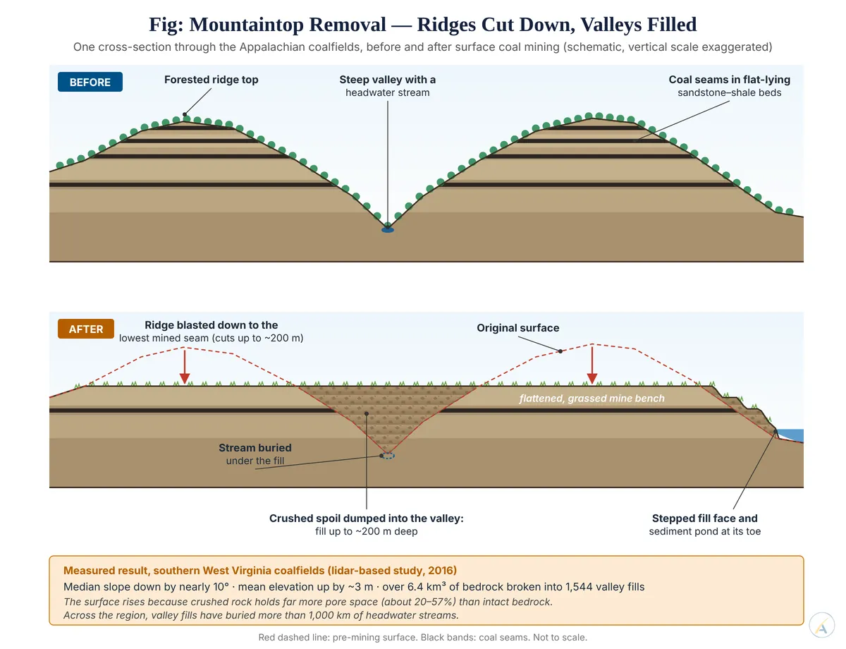
- Relief flattening. Matthew R. V. Ross, Brian L. McGlynn and Emily S. Bernhardt found in 2016 that mountaintop mining in southern West Virginia lowered the median slope of mined landscapes by nearly 10 degrees, broke up more than 6.4 cubic kilometres of bedrock into 1,544 valley fills, and raised the average surface by about 3 m.
- Drainage destruction. Across Appalachia, valley fills have buried well over 1,000 km of headwater streams — by some estimates about 3,200 km; divides are breached, catchments beheaded, and abandoned voids fill as pit lakes.
- Subsidence and combustion, where worked-out ground collapses and exposed seams ignite.
- Mass movement on spoil. Tip material has no cohesion, compaction or drainage. At Aberfan on 21 October 1966 a colliery tip built over springs liquefied after heavy rain, killing 144 people, 116 of them children.
- Acid mine drainage. Pyrite oxidation on fresh faces acidifies runoff; streams draining the Jaintia Hills coal pits of Meghalaya run near pH 4, with fish largely lost, and the Lukha and Kopili are among the rivers affected.
- Soil and sediment. The A and B horizons go outright; Anthony H. Cooper and colleagues put direct anthropogenic sediment production at 316 gigatonnes in 2015, over 24 times what the world’s major rivers deliver to the oceans.
Examples
- Jharia, burning since 1916: surface fire fell from 67 sites over 17.32 sq km (2009 master plan) to 27 sites over about 1.80 sq km (2020–21 survey); the Union Cabinet approved a revised ₹5,940 crore master plan in June 2025.
- Rat-hole workings in the north-east — the Ksan flooding of 13 December 2018, which trapped 15 miners, and Umrangso on 6 January 2025, nine dead.
- Aravalli quarrying: a 100-metre relief threshold for a protected hill, accepted by the Supreme Court in November 2025, drew criticism that it left most of the range unprotected. The Court put it in abeyance on 29 December 2025, halted Aravalli mining in May 2026 until a revised definition is settled, and has set 30 November 2026 for its expert committee’s report.
- Goa, where 88 iron ore leases were quashed in February 2018.
- Globally: Bingham Canyon, Utah, about 1,210 m deep; Madre de Dios, Peru, with 135,939 hectares of gold-mining deforestation by mid-2025; and some 50 billion tonnes of sand and gravel taken worldwide each year.
Measuring the footprint
- Victor Maus, Stefan Giljum and colleagues mapped global mining land use at 101,583 sq km from 2019 imagery, published in 2022 — nearly double their own earlier estimate of 57,277 sq km. The footprint was never stable, only under-measured.
- Reclamation restores cover, not form: Tarun Kumar Thakur and colleagues found in 2025 that forest cover in the Korba coalfield of Chhattisgarh fell from 35.56 per cent in 1995 to 14.06 per cent in 2024, with degradation outpacing restoration.
- India’s degradation accounting places 97.85 million hectares, 29.7 per cent of the country, under land degradation without breaking mining out as a separate process.
- Judgement: scarification is the most intense form of land degradation per unit area and the least counted — it rebuilds relief, drainage and soil at once, so its control needs landform-level reclamation and separate accounting, not just replanting.