

What is ‘Base level’ ? Explain the types of base level. (2013)
- Base level is the lowest level to which a stream can erode its bed — the lower limit of fluvial downcutting, and more broadly the level towards which all subaerial denudation works.
- John Wesley Powell introduced the term in 1875 while studying the Colorado River canyons:
- “We may consider the level of the sea to be a grand base level, below which the dry lands cannot be eroded; but we may also have, for local and temporary purposes, other base levels of erosion” — John Wesley Powell
- William Morris Davis made it the floor of his geographical cycle (1899): a landmass is worn down towards base level until it becomes a peneplain.
How Base Level Controls a River
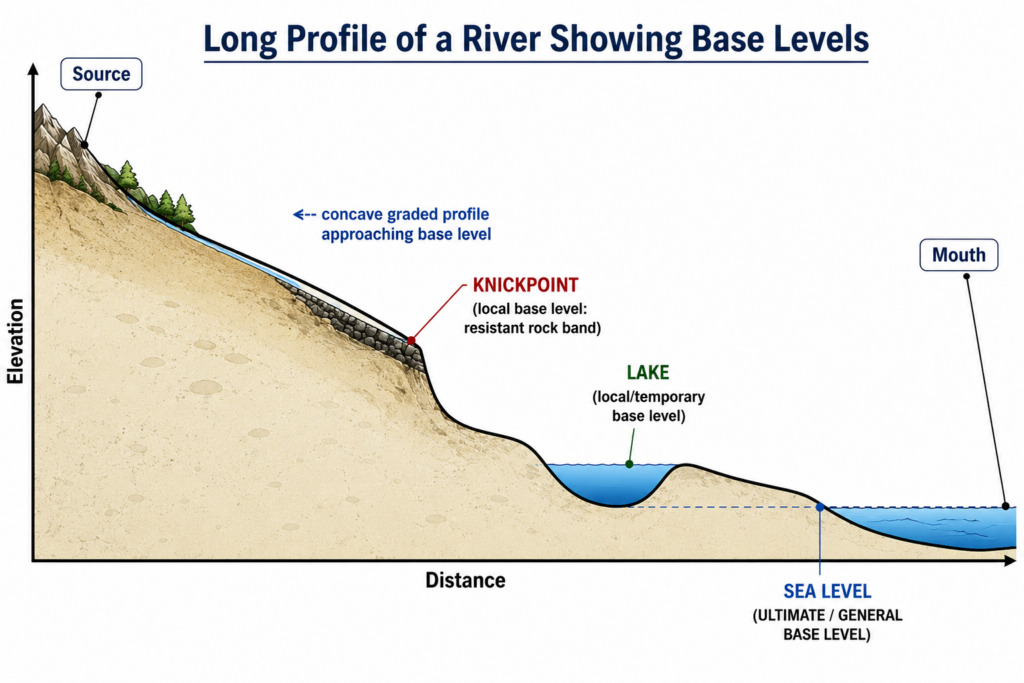
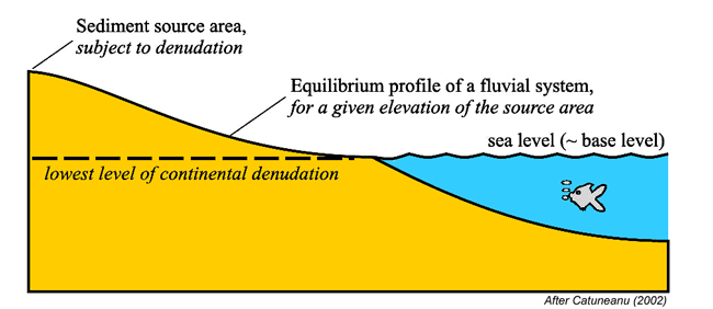
- A river adjusts its gradient, velocity and load towards a smooth, concave-upward graded profile that meets its base level at the mouth.
- While base level is steady, erosion and deposition work towards that profile; any change in base level upsets the equilibrium:
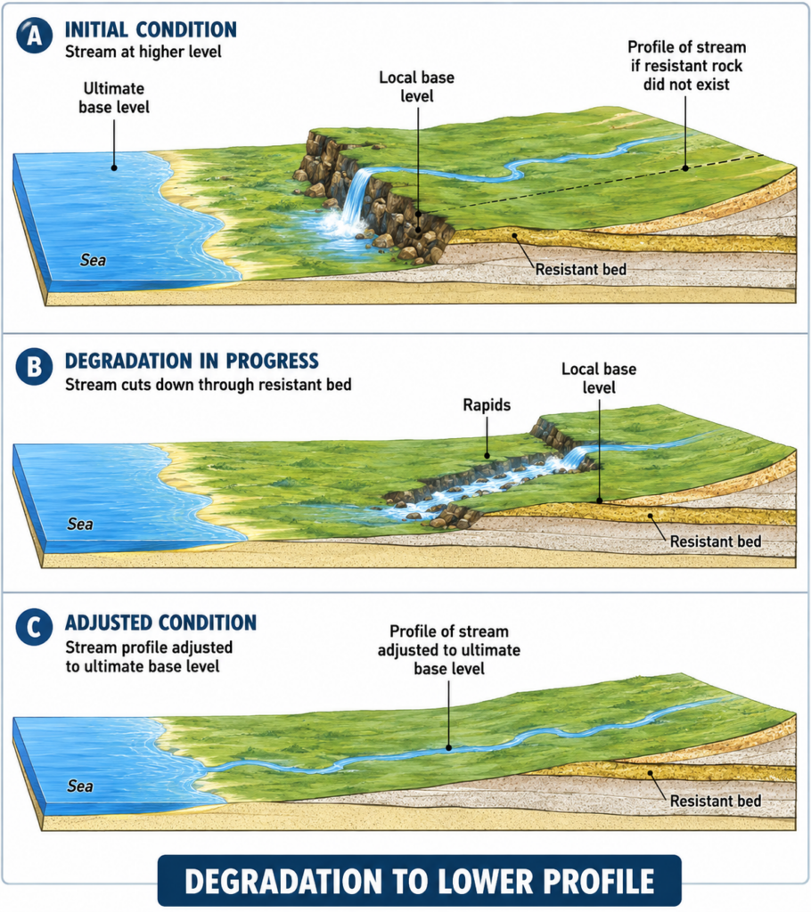
- a fall steepens the lower course and drives downcutting;
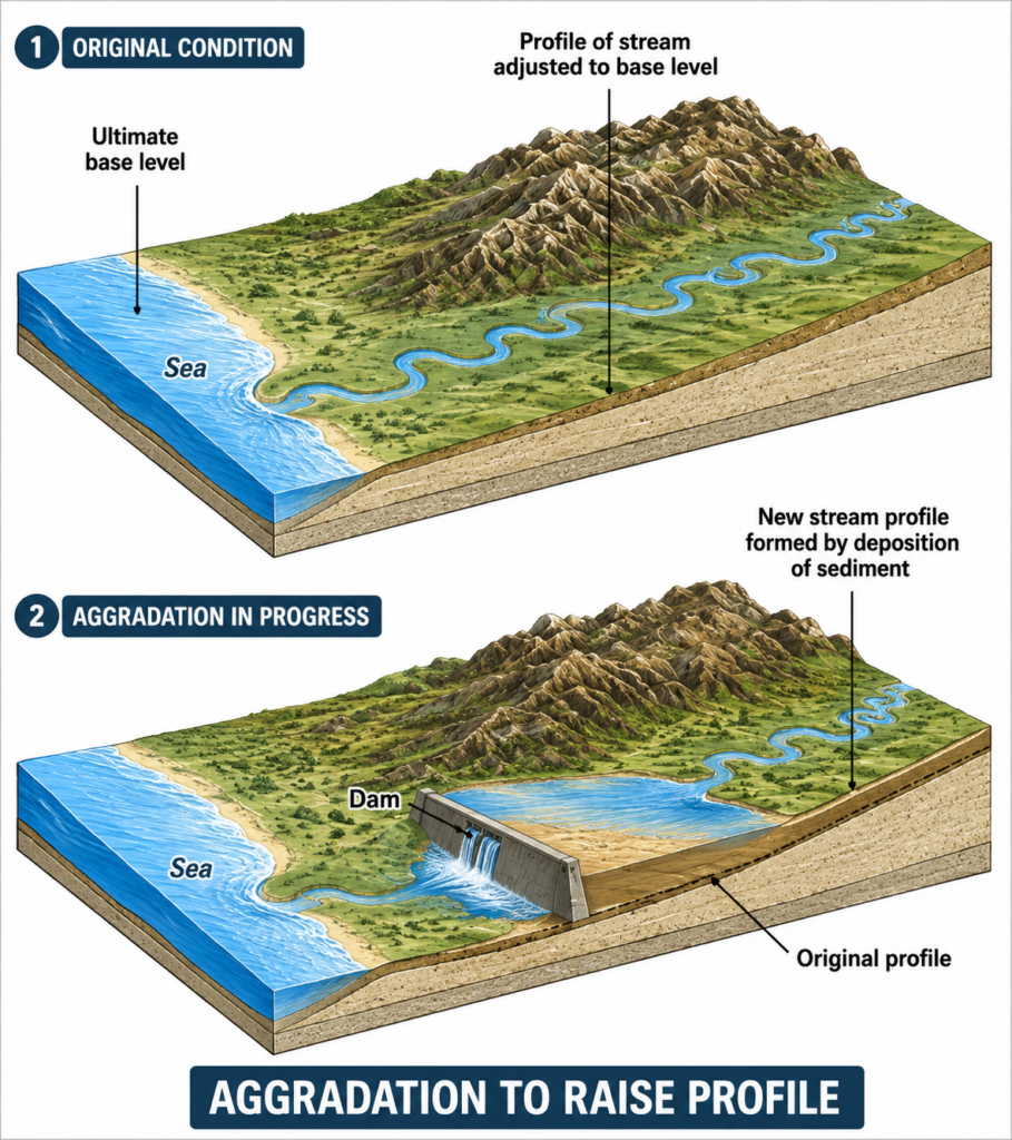
- a rise reduces the gradient and drives deposition (aggradation).
- Base level is approached but never reached across a whole basin, because the gradient falls towards zero as the profile nears it.
Types of Base Level
1. Ultimate (general or grand) base level
- Sea level, projected beneath the continents, is the ultimate base level — the lowest level to which a landmass draining to the ocean can be reduced.
- It is a limit, not a fixed line, because sea level itself moves:
- eustatic change — a worldwide change in ocean volume, through ice-sheet growth and melting or changes in ocean-basin capacity;
- tectonic and isostatic change — uplift or subsidence of the land that alters the relative level of land and sea.
- It is moving now: the World Meteorological Organization reported in 2023 that global mean sea level rose about 4.62 mm a year over 2013–2022, roughly double the rate of the first decade of satellite records (1993–2002) — the ultimate base level of the world’s rivers is rising.
2. Local and temporary base levels
- Any control that halts downcutting above the ultimate base level, for one reach or for a limited time. Powell grouped “local and temporary” together; some classifications keep “local” for the tributary–trunk junction and “temporary” for lakes and rock bars.
- Resistant rock band (structural base level): a bar of hard rock across the channel holds up the reach above it and forms a waterfall or rapids until it is cut through.
- Lake: a lake fixes the level below which the river entering it cannot erode; the inflowing river builds a delta into it.
- Reservoir behind a dam: an artificial temporary base level — the river aggrades upstream as sediment settles in the reservoir, as in large Himalayan reservoirs such as Bhakra and Tehri.
- Confluence: for a tributary, the level of the trunk stream at the junction is its base level; if the trunk river degrades, the tributary is rejuvenated; if the trunk aggrades, the tributary aggrades too.
- All are temporary on a geological timescale — erosion, breaching or siltation removes them, and the stream then grades to the next lower control.
3. Base levels of closed (endorheic) basins
- A basin with no outlet to the sea grades to its own interior sink, independent of sea level and sometimes far below it:
- the Dead Sea surface lies about 440 m below sea level (2025), and as it falls, streams entering it incise and sinkholes open along its shore;
- during the Messinian Salinity Crisis (about 6 million years ago) the isolated Mediterranean partly dried, dropping its base level by more than 1,000 m and letting rivers such as the Nile cut deep canyons.
Base-Level Change and Landforms
- Fall in base level (uplift or relative sea-level fall) → rejuvenation: knickpoints migrating upstream, incised meanders, paired terraces and polycyclic (multi-storeyed) valleys.
- Rise in base level (subsidence, sea-level rise or damming) → aggradation: drowned valleys forming rias and estuaries, wide floodplains and buried channels. The postglacial sea-level rise of about 120 m since the last glacial maximum drowned the lower courses of rivers worldwide.
- Removing a base level works the same way: after the Elwha and Glines Canyon dams were removed in the United States (2011–2014), the river cut down through its old reservoir deposits and released sediment that rebuilt its delta and beaches.
- Judgement: base level is best understood as a hierarchy of controls — one ultimate control set by sea level and a shifting set of local, temporary and interior ones that govern the profile actually seen; with sea level now rising and dams adding and removing base levels, it is a live management concept, not only the floor of the Davisian cycle.