

What is a Yazoo stream ? Why are Yazoo basins the areas of repeated flooding ? Give examples of Yazoo stream/areas from various parts of the world. (2024)
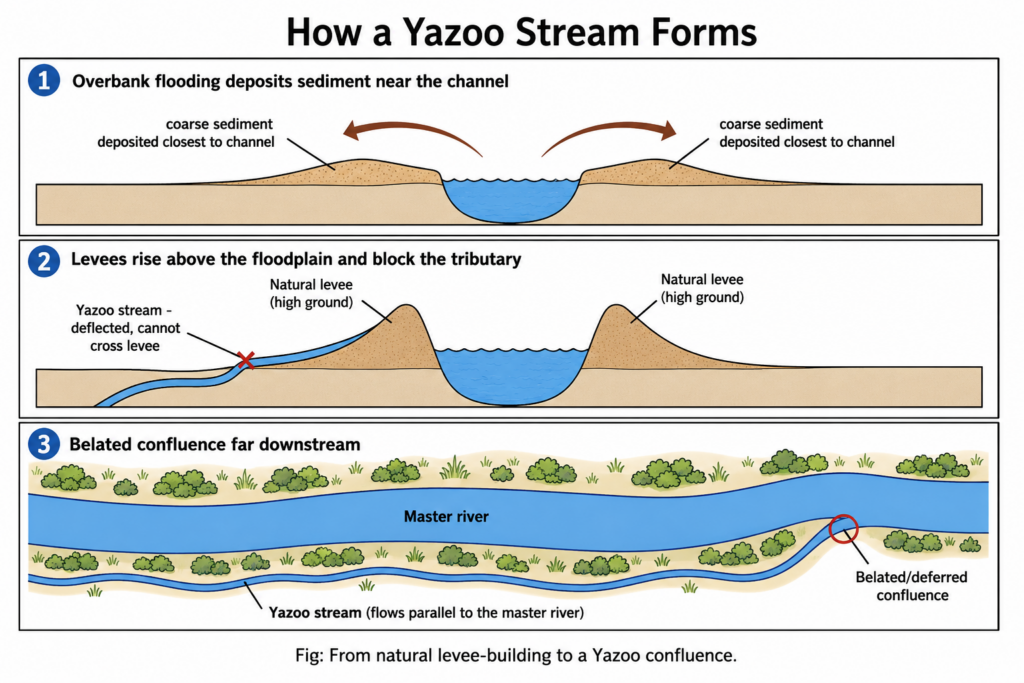
- A Yazoo stream is a tributary that runs parallel to a larger master river, within its floodplain, for a long distance because the master river’s natural levees stand higher than the floodplain and bar a direct junction; it joins only at a deferred (belated) confluence downstream, where the levee is breached, low or absent.
- The name comes from the Yazoo River of Mississippi, USA — the type example, held off the Mississippi by its levees until just north of Vicksburg.
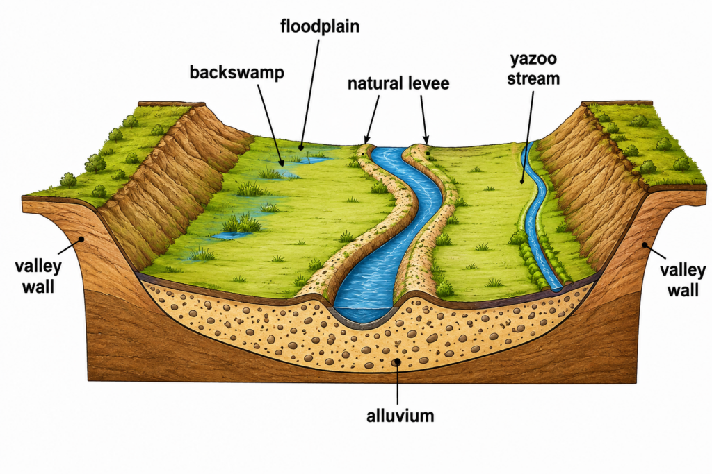
- The Yazoo basin is the low strip between the master river’s levee and the valley wall — the backswamp tract in which the Yazoo stream flows.
How a Yazoo Stream Forms
- In its lower course a large river carries a heavy suspended load on a very gentle gradient. At every flood, water spilling over the bank loses velocity abruptly, so the coarsest silt and fine sand drop closest to the channel.
- Flood after flood, these deposits build natural levees — low ridges flanking the channel, typically up to about 10 m high (about 6–7.6 m on the lower Mississippi). They are the highest ground on the floodplain; the land slopes away from the river towards the backswamp and the valley wall.
- A floodplain tributary therefore meets the back-slope of the levee instead of the river. Unable to cross it, it is deflected downvalley, hugging the levee foot or the valley wall, until a gap or the end of the levee lets it in.
- The more actively the master river aggrades, the higher its levees and the longer the tributary’s parallel course — Yazoo streams are a by-product of the master river’s own deposition.
Why Yazoo Basins Flood Repeatedly
Natural causes — the geometry
- Reverse slope: the basin surface falls away from the river, so spill water and rain cannot drain back into the main channel; water collects in the lowest tract — exactly where the Yazoo stream flows.
- Single, distant outlet: everything must travel the full length of the tributary to the deferred confluence, so basins stay waterlogged long after the flood crest has passed.
- Backwater at the confluence: when the master river is in flood, its high stage backs water up the Yazoo — the tributary cannot discharge, and may even flow backwards.
- Three sources at once: overbank spill or levee breach from the master river, the tributary’s own flood, and local rain falling on the basin.
- Clay-rich backswamp soils and a high water table allow little infiltration, so even moderate rain ponds for weeks.
Human amplification
- Artificial levees raise the master river’s flood stage, and the gates closing tributary outlets must shut whenever the main river runs high — trapping interior rainfall behind them.
- Yazoo Backwater Area, 2019: with the Mississippi high for months, the Steele Bayou drainage structure stayed closed; ponded rain covered over 550,000 acres (about 2,200 km²) by late May, about 250,000 acres of it farmland, and 222 homes were destroyed. A pumping scheme blocked by the US Environmental Protection Agency in 2008 has since been revived — an engineering response to a problem the basin’s geometry creates.
Examples from Different Parts of the World
| Region | Master river | Yazoo stream / area |
|---|---|---|
| North America | Mississippi | Yazoo River — formed at Greenwood by the Tallahatchie and Yalobusha, runs about 303 km along the eastern edge of the Yazoo–Mississippi Delta below the bluffs, entering just north of Vicksburg |
| East Asia | Huang He (Yellow River) | Extreme case: the lower river is a levee-confined “suspended river”, its bed about 10 m above the plain at Kaifeng; it receives very few tributaries in its lower reaches — most floodplain streams cannot join it and drain away to the Huai and Hai basins |
| South Asia (West Bengal) | Bhagirathi | Mayurakshi — its levees and backswamps hold it parallel to the Bhagirathi for about 25 km (straight-line) before a shifting confluence; Raghunath Pal (2015) describes it as a Yazoo tributary |
| South Asia (Bihar) | Gandak / Ganga | Burhi Gandak (Yazoo-type) — flows parallel to and east of the Gandak in an old Gandak channel and never joins it, reaching the Ganga only far downstream near Khagaria |
| North America (other) | Wakarusa (Kansas); Mendenhall (Alaska) | Small Yazoo streams draining the backswamps of the Wakarusa valley; Montana and Jordan creeks, Yazoo-type tributaries of the Mendenhall River near Juneau |
- The cases form a gradient: the Yazoo and the Mayurakshi are classic deferred confluences; the Burhi Gandak shows a similar deflection on the North Bihar plains; the Huang He is the end-point, where the levee-perched river becomes a drainage divide.
- Judgement: a Yazoo stream is not an oddity but the predictable result of a river raising its own banks. The same levee ridge that keeps the master river’s floods in its channel is the wall that traps its neighbour’s water — so engineering that raises levees, without drainage outlets or pumps, deepens rather than solves the Yazoo basin’s flood problem.