

What are ‘truncated spurs’ ? Where and how are they formed ? (2024)
- A truncated spur is a spur — a ridge running down from higher ground toward a valley floor — whose lower end has been cut off, leaving a steep, roughly triangular inverted-V rock face on the valley side.
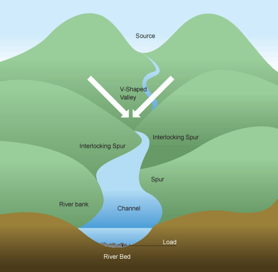
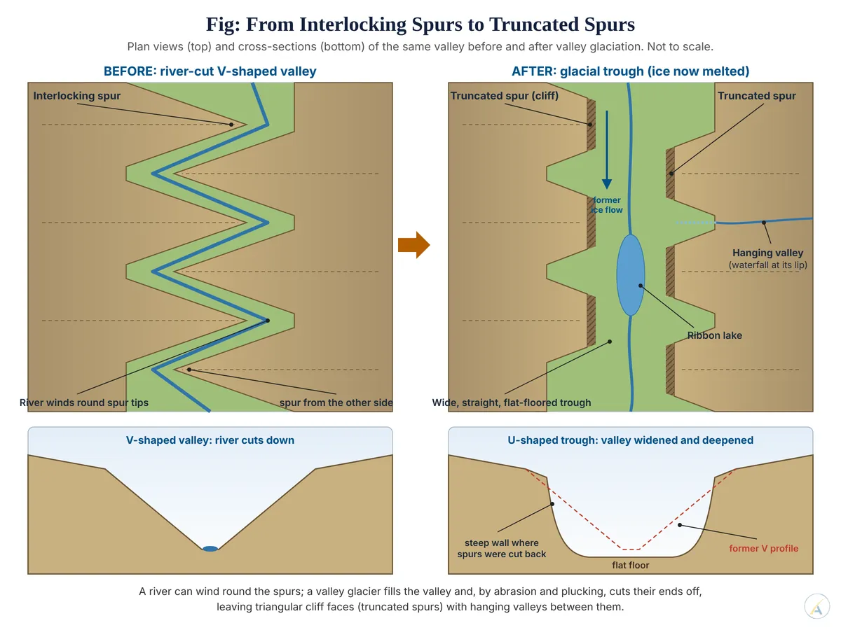
- The term only makes sense against its starting form, the interlocking spur. A young river cutting down into bedrock follows zones of weakness such as joints, so its valley zig-zags; ridges project alternately from opposite sides into each bend and, seen from upstream or from above, they overlap like the teeth of a zip.
- A river can wind round these spurs. A valley glacier cannot: it fills the valley from side to side and moves as a thick, broad mass that cannot turn tight bends, so it grinds the spur ends away instead.
- The landform is therefore erosional evidence of glacial straightening — proof that ice occupied, and remodelled, a valley that a river had cut first.
Where Truncated Spurs Are Formed
- Glaciated mountain valleys (glacial troughs) are the classic setting: valleys cut by rivers before or between glaciations and later occupied by valley glaciers, in the Pleistocene or today.
- They occur with the other trough features — the broad, steep-walled U-shaped valley, hanging valleys with waterfalls between the spurs, ribbon lakes and rock steps on the floor.
- Classic locations:
- The Lauterbrunnen valley in the Swiss Alps, a U-shaped trough whose cliff walls rise up to about 1,000 m, with Staubbach Falls (297 m) dropping from a hanging valley.
- Yosemite Valley in the Sierra Nevada, USA.
- The Mer de Glace valley near Chamonix, where a glacier is still cutting into the valley sides.
- The glaciated upper valleys of the Greater Himalaya and the Karakoram.
- Confined valley glaciers matter: truncation is sharpest where ice is channelled by high relief. Where an ice sheet buried the whole landscape, spurs were more often smoothed and streamlined than cut back into cliffs.
- Non-glacial settings: the term also covers spurs cut back by lateral river erosion or by waves along a coast. On the Bhander plateau of the Vindhyan region, long-continued subaerial denudation has left truncated spurs alongside precipitous scarps, waterfalls and flat-topped detached hills.
- A look-alike to rule out: faceted spurs along an active fault, such as the Wasatch Front of Utah, have similar triangular faces but owe them to faulting, not glacial erosion.
How Truncated Spurs Form
- Stage 1 — fluvial valley: in the pre-glacial phase the river incises vertically and winds between interlocking spurs in a V-shaped valley.
- Stage 2 — ice occupies the valley: snow accumulating in cirques feeds a valley glacier that advances down the old river valley and fills it to a level far above the former river.
- Stage 3 — erosion of the spur ends: the glacier slides along its bed and sides, and two processes do the work:
- Abrasion — rock debris frozen into the base and sides of the ice scrapes and polishes the projecting spur ends.
- Pressure is greatest on the up-valley face and nose of each spur, which lie directly in the path of the ice, so erosion is concentrated exactly where the spur projects.
- Plucking (quarrying) — meltwater refreezes in joints; the moving ice then wrenches out whole blocks, so well-jointed spur noses are removed fastest.
- Stage 4 — straightening and deepening: the spur tips are bevelled off into steep cliff faces, the valley sides are straightened, and the floor is deepened and widened into a U-shaped trough.
- Stage 5 — after the ice melts: the truncated spurs stand as triangular cliffs along the trough walls. Tributary glaciers, which deepened their beds far less than the trunk glacier, leave hanging valleys between them, often with waterfalls.
A Live Debate: How Much Do Glaciers Actually Carve?
- The protectionist view: some early writers held that ice mainly protects the ground it covers, so glacial troughs are essentially river valleys only lightly modified.
- The erosionist view: others treated glaciers as powerful excavators that deepen and widen valleys far beyond what rivers achieve — witness overdeepened rock basins and fjords cut below sea level.
- What current research says: Frédéric Herman and colleagues (2021), reviewing field measurements, showed that glacial erosion rises with the speed of basal sliding. Fast-sliding, warm-based ice abrades and plucks vigorously; cold-based ice, frozen to its bed, hardly erodes at all.
- The debate is therefore largely resolved by thermal regime:
- Both schools were partly right — the same glacier can protect one part of a landscape and excavate another.
- Truncated spurs, which need sliding ice pressing against the valley walls, mark the zones where the ice was warm-based and fast-flowing.
- Because the spurs inherit a river’s interlocking pattern, they also show that glaciers usually rework an existing valley rather than cut a new one from scratch.
- The same tension in hanging valleys: do they hang because the trunk glacier overdeepened its bed, or because thin tributary ice failed to keep pace? Sliding-dependent erosion supports the first answer: thicker, faster trunk ice cuts down faster.
Significance
- Field diagnosis: a line of truncated spurs with hanging valleys between them is one of the clearest signs that a valley has been glaciated, distinguishing it from a purely fluvial V-shaped valley.
- Reconstructing old ice: the height of the truncation on the valley walls indicates the minimum former ice thickness.
- Hazards: steep spur faces released from ice support are prone to rockfall and rock-slope failure, a growing concern in Himalayan valleys as glaciers thin.
- Judgement: a truncated spur is best read as the signature of fast, warm-based ice forced through a river-cut valley — strong evidence that glaciers remodel inherited landscapes rather than invent them, and a reminder that the old erosion-versus-protection argument depends on the ice’s thermal regime more than on ice as such.