

Stream basins and drainage divides are important components to delineate a watershed area. Explain. (2021)
- A watershed (also called a drainage basin or catchment) is the whole land surface that drains, through one stream network, to a single outlet.
- Delineating it needs two complementary elements:
- the stream basin — the channel network inside, which fixes where the water goes;
- the drainage divide — the bounding line, which fixes from how far the water comes.
- Robert E. Horton (1945) made the drainage basin a measurable unit of geomorphology, and Arthur N. Strahler (1952–57) refined its stream ordering; both methods assume a basin already closed by its divide.
The Stream Basin: The Internal Drainage Structure
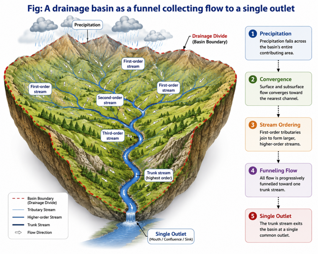
- The basin works as a funnel: precipitation falling anywhere inside it moves as overland flow and throughflow to the nearest channel, then down a hierarchy of tributaries to one trunk stream and one outlet.
- Exorheic and endorheic basins: most basins drain to the sea, but endorheic basins end in an inland sink — the Caspian Sea, the Dead Sea, or the saline lakes such as Sambhar in the area of inland drainage on the eastern margin of the Thar. Here the “outlet” used for delineation is an interior low point, not a coastline.
- Strahler ordering gives the network a comparable hierarchy:
- unbranched headwater channels are first order;
- order rises by one only where two streams of equal order meet;
- the order at the outlet is a rough index of how much area the trunk stream integrates.
- Morphometry is what makes a delineated basin useful:
- drainage density (channel length per unit area) — high density means rapid runoff and flashy floods;
- bifurcation ratio — commonly 3 to 5 where geology does not distort the network;
- drainage pattern — dendritic on uniform rock, trellis on folded strata (the Appalachians), radial on domes and volcanic cones.
- The network also decides which watershed is being delineated, because a watershed is defined by its chosen outlet: the Mahanadi basin covers about 145 lakh ha, but the catchment of Hirakud dam on the same river only about 83 lakh ha.
The Drainage Divide: The Boundary That Makes the Basin Definite
- A drainage divide is the line of highest ground between adjacent basins: rain falling on one side reaches one outlet, rain falling a metre away on the other side reaches another.
- Divides are nested:
- the Western Ghats crest is the main water divide of Peninsular India — west of it rivers reach the Arabian Sea, east of it most reach the Bay of Bengal;
- minor divides separate sub-basins and micro-watersheds inside a basin, so one point belongs at once to a micro-watershed, a river basin and an ocean drainage.
- Legibility varies with relief:
- divides are sharp and easy to trace in youthful, high-relief terrain such as the Himalayan interfluves;
- they become broad and vague on old, low-relief surfaces and alluvial plains, where flat interfluves, marshes, canals and embankments blur the boundary.
- A divide therefore need not follow a mountain range: it may run across a gentle rise or a terrace edge, which is why it must be traced explicitly rather than assumed.
- Divides are not fixed. Adam M. Forte and Kelin X. Whipple (2018) showed that contrasts across a divide — in channel elevation, slope and local relief — reveal whether it is migrating; a migrating divide, or a river capture, shifts drainage area from one basin to its neighbour. A delineation is thus a snapshot of a moving boundary.
Delineating a Watershed: Basin and Divide Working Together
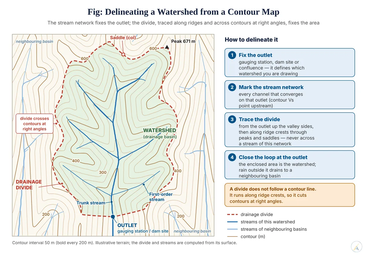
- Manual method on a contour map:
- fix the outlet (a gauging station, dam site or confluence);
- from it, draw the divide up the ridge lines, through hilltops and saddles, crossing every contour at right angles;
- keep every channel of the network on the inner side, and close the line back at the outlet — the enclosed area is the watershed.
- Digital method: the D8 flow-direction method of John F. O’Callaghan and David M. Mark (1984) sends each cell of a digital elevation model to its steepest of eight neighbours; flow accumulation then traces the streams, and the set of cells draining to the outlet is the watershed, its edge the divide.
- It works well in hills; on flat alluvial plains small elevation errors misroute flow, so the mapped stream network is often “burnt” into the elevation model — the network corrects the divide.
- Neither element alone is enough:
- a stream network without its divide leaves the contributing area undefined;
- a divide traced without the network gives a closed line with no proof of a single outlet — it could enclose a closed depression.
- India’s watershed programmes, including the Watershed Development Component of the Pradhan Mantri Krishi Sinchayee Yojana, rest on this logic: basins are subdivided into catchments, sub-catchments, watersheds, sub-watersheds and micro-watersheds, each fixed by an outlet and its divide.
Conclusion
- The stream basin and the drainage divide are not two features that happen to co-occur; they are the two halves of one definition — the network gives the watershed its single outlet, the divide gives it its area.
- The difficulty of delineation itself follows relief: easy where divides are sharp, error-prone on plains where they are diffuse.
- Judgement: the statement holds fully — a watershed is delineated only when an outlet, the network converging on it and the divide enclosing that network agree; because divides migrate and plains blur them, that agreement must be checked in the field, not merely computed.