

Question: State the concept of erosion surfaces and highlight the factors responsible for their development.
Introduction: Concept of Planation & Historical Significance
An erosion surface (interchangeably termed a planation surface or palaeoplain) is a geographically extensive, gently undulating to near-planar bedrock surface produced by the prolonged, uninterrupted denudation of an uplifted landmass down to low relief, graded toward regional or ultimate base level, regardless of the underlying geological structure and lithology.
First formalised in American geomorphology by G.K. Gilbert (1877) as “the removal of rock so as to produce an even surface which may, at the same time, be covered with alluvial deposits”, the concept was elevated by W.M. Davis (1899) into the crowning terminal stage of his cycle of erosion — the peneplain.
In contemporary geomorphology (C.R. Ollier, 1981; R.J. Small, 1970; Richard Huggett, 2011), planation surfaces are recognized as geomorphic palimpsests and indispensable morpho-stratigraphic time markers. They record quiescent intervals in Earth’s tectonic history during which crustal stability permitted subaerial agents to bevel diverse rock structures, prior to being uplifted, tilted, dissected, or buried. As C.R. Ollier observed, “most people who are not blind or stupid can recognise a plain when they see one”, and their identification underpins the entire discipline of denudation chronology.
1. The Geomorphic Distinction: Erosion Surface vs. Structural Surface
A fundamental requirement in geomorphic mapping (R.J. Small, 1970) is distinguishing a genuine erosion surface from a structurally controlled bench:
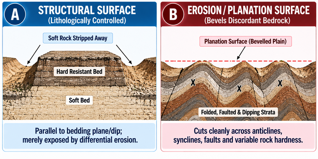
- Structural Surface: Formed where exogenic stripping removes an overlying weak stratum, exposing the flat, resistant dip-slope of an underlying horizontal layer. Its morphology is strictly governed by rock dip and bedding planes (e.g., stripped limestone or basalt benches).
- True Erosion Surface (Planation Surface): Discordant to underlying geology; it cleanly truncates folded, faulted, steeply dipping, and heterogeneous rock complexes alike, proving it to be the product of an independent, pervasive regional levelling process.
2. Comprehensive Taxonomy of Erosion / Planation Surfaces
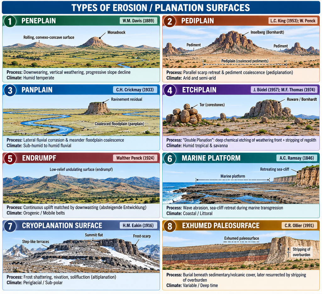
Planation surfaces are polygenetic, classified by their dominant formative process, morphogenetic climate, and seminal thinker:
| Surface Type | Dominant Process & Mechanism | Morphoclimatic Setting | Characteristic Morphology | Seminal Geomorphologist |
|---|---|---|---|---|
| 1. Peneplain | Downwearing, vertical weathering, progressive slope decline | Humid temperate | Rolling, convexo-concave relief with gentle, rounded monadnocks | W.M. Davis (1889) |
| 2. Pediplain | Parallel scarp retreat & pediment coalescence (pediplanation) | Arid and semi-arid | Multi-concave bedrock pediments with steep bornhardts and inselbergs | L.C. King (1953); W. Penck |
| 3. Panplain | Lateral fluvial corrasion & meander floodplain coalescence | Sub-humid to humid fluvial | Dead-flat, featureless plain with steep-sided ravinement residuals | C.H. Crickmay (1933) |
| 4. Etchplain | “Double Planation”: deep chemical etching of weathering front + stripping of regolith | Humid tropical & savanna | Stripped bedrock plain, corestones, tor landscapes, ruwares, bornhardts | J. Büdel (1957); M.F. Thomas (1974) |
| 5. Endrumpf | Continuous uplift matched by downwasting during waning stages (absteigende Entwicklung) | Orogenic / Mobile belts | Low-relief undulating terminal form under continuous uplift | Walther Penck (1924) |
| 6. Marine Platform | Wave abrasion, sea-cliff retreat during marine transgression | Coastal / Littoral | Extremely planar bedrock ramp, veneered by marine gravel and sand | A.C. Ramsay (1846) |
| 7. Cryoplanation Surface | Frost shattering, nivation, solifluction (altiplanation) | Periglacial / Sub-polar | Stepped bedrock terraces, summit flats bounded by frost-scarps | H.M. Eakin (1916) |
| 8. Exhumed Paleosurface | Burial beneath sedimentary/volcanic cover, later resurrected by stripping of overburden | Variable / Deep time | Fossil landform preserving paleotopography (e.g., glaciated bedrock) | C.R. Ollier (1991) |
3. Factors Responsible for the Development of Erosion Surfaces
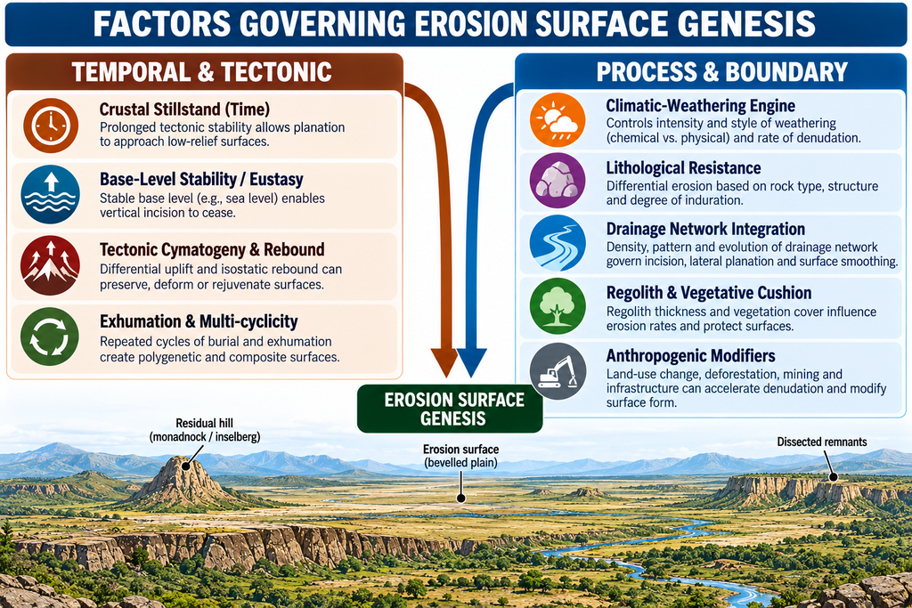
The genesis of an erosion surface is governed by the complex interplay of endogenic stability and exogenic denudational efficiency:
A. Time and Duration of Tectonic Quiescence
- The Primary Prerequisite: Complete continental-scale planation requires immense, uninterrupted durations of tectonic stillstand (tens of millions of years — typically 10 to 100 million years).
- If tectonic uplift or climatic disruption occurs prior to completion, the cycle is interrupted, leaving behind partial, fragmented surfaces classified as incipient peneplains, strath terraces, or local erosion benches.
- Example: The ancient cratonic shield of Peninsular India experienced prolonged Mesozoic quiescence, permitting continental-scale planation prior to Deccan volcanism.
B. Base-Level Control and Eustasy
- Ultimate Base Level: Sea level acts as the thermodynamic and hydraulic datum below which subaerial fluvial erosion cannot cut. As streams grade toward base level, vertical corrasion ceases, forcing available stream power into lateral planation.
- Eustatic Sea-Level Fluctuations: Quaternary glacial-interglacial cycles caused global sea levels to oscillate by plus or minus 120 metres. Marine transgressions drown coastal surfaces under sediment veneers; regressions trigger rejuvenation, knickpoint retreat, and dissection of existing surfaces.
C. Tectonic Framework: Stability versus Cymatogenic Warping
- Persistent cratonic stability allows planation to broaden laterally. Conversely, epeirogenic or cymatogenic uplift (L.C. King) arches the crust, elevating surfaces into the upland zone as dissected plateaus.
- Example: The Chotanagpur Highlands preserve uplifted surfaces stepped at different elevations, recording pulsed Tertiary epeirogenic responses to the Himalayan collision.
D. Climate and Morphogenetic Systems
- Climate dictates the dominant chemical or physical weathering engine:
- Humid Tropical Climates: Deep chemical decomposition rots bedrock up to 50 to 100 metres depth. Episodic stripping of this saprolite down to the basal weathering front generates etchplains (e.g., Western Ghats lateritic plateaus).
- Arid and Semi-Arid Climates: Dominance of mechanical weathering, ephemeral sheetfloods, and scarp retreat produces pediplains (e.g., Aravalli pediments).
- Periglacial Climates: Intense freeze-thaw produces cryoplanation terraces.
E. Lithology and Rock Resistance (Differential Erosion)
- Weak, homogeneous rocks (shales, phyllites, schists) planate rapidly. Highly resistant lithologies (quartzites, granites, charnockites) retard denudation.
- Differential erosion leaves residual masses standing above the belevelled datum as monadnocks (Davisian downwearing residuals) or inselbergs and bornhardts (Kingian scarp-retreat residuals; e.g., Kanke Dome and Ranchi gneissic inselbergs).
F. Drainage Network Integration & Hydraulic Efficiency
- A fully integrated, high-density drainage network evacuates weathered detritus efficiently, lowering interfluves uniformly. Immature, disorganised drainage leads to localized, uneven erosion, retarding regional planation.
G. Regolith Armor and Vegetative Cushion
- Dense forest canopies and deep root networks bind soils and dampen slope wash, retarding mechanical lowering. When climate dries or vegetation thins, sheetwash rapidly strips saprolite, exposing the flat bedrock floor.
H. Exhumation of Fossil Unconformities
- Ancient erosion surfaces can be submerged, buried beneath sediments or flood basalts, and preserved for geological epochs. Subsequent stripping of the softer sedimentary cover exhumes the ancient planation surface.
- Example: The Kimberley Plateau of Western Australia preserves a 700-million-year-old (700 Ma) Sturtian glaciated planation surface recently exhumed from beneath glacial till (Huggett, 2011).
4. Empirical Indian Field Evidence: Polycyclic Staircases
A. Polycyclic Planation Surfaces of Chotanagpur Highlands (R.P. Singh, 1969)
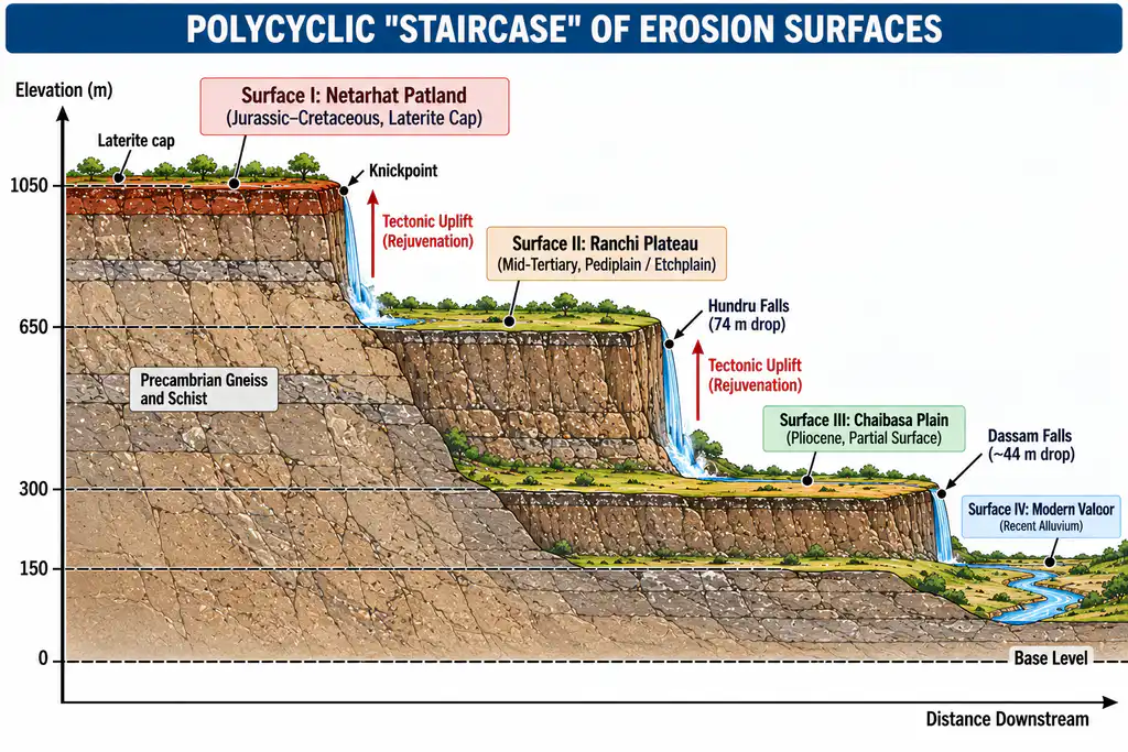
Classical field mapping and morphometric profile analysis in Jharkhand demonstrate a multi-tiered staircase of uplifted planation surfaces:
- The Patlands (Western Highlands / Netarhat Pat): Standing at approx. 1,065 m (approx. 3,500 ft); an ancient Jurassic peneplain capped by Cretaceous Deccan lava and bauxitic laterite, uplifted during early Tertiary Himalayan collision.
- Ranchi & Hazaribagh Plateau Surface: Standing at approx. 650 to 700 m (approx. 2,000 ft); a mid-Tertiary planation surface bevelled across granitic-gneissic basement.
- Lower Chotanagpur / Chaibasa Plain: Standing at approx. 150 to 300 m (approx. 500 to 1,000 ft); a late Pliocene-Pleistocene partial erosion surface.
- Rejuvenation Nickpoints: The stepped scarps separating these surfaces are marked by dramatic waterfalls — Hundru Falls (Subarnarekha, 74-metre drop), Dassam Falls (Kanchi, 40-metre drop), and Jonha / Gautamdhara Falls (Raru).
B. The Belan Basin Erosion Surfaces (Savindra Singh & R. Srivastava, 1976)
Morphometric analysis (superimposed profiles and altimetric frequency curves) across the Vindhyan foreland of southern Uttar Pradesh identified four distinct erosion surfaces:
- Kaimur Surface: Approx. 427 m (1,350 to 1,400 ft) — dissected upland plateau surface.
- Panna Surface: 305 to 366 m (1,000 to 1,200 ft) — intermediate planation level.
- Rewa Surface: Approx. 240 m (800 ft) — well-developed erosion surface.
- Trans-Yamuna-Ganga Surface: Approx. 150 m (500 ft) — lowest planation surface graded to Quaternary river levels.
Conclusion
The concept of erosion surfaces bridges the divide between process geomorphology and deep geological time. Far from being mere theoretical constructs of Davisian orthodoxy, genuine planation surfaces are empirically verifiable landscape features that bevel diverse structural fabrics. Their genesis is governed by the critical equilibrium between prolonged crustal quiescence, base-level stability, climatic weathering regimes, and drainage integration. In polycyclic terrains like Peninsular India, stepped erosion surfaces serve as indispensable geomorphic archives, documenting the sequential pulses of tectonic uplift, paleoclimatic shifts, and base-level adjustments that have carved Earth’s continents.