

Question: Provide a critique of the concept of peneplain. How did Crickmay try to improve upon Davisian idea of peneplain by providing the concept of panplain?
Introduction: The Davisian Paradigm & Its Discontents
The peneplain (“almost a plain”, from Latin paene) was conceived by William Morris Davis (1889, 1899) as the ultimate, penultimate morphological end-product of his Geographical (Fluvial) Cycle of Erosion. In Davis’s deduction, an uplifted landmass undergoing uninterrupted subaerial denudation in a humid temperate climate progresses through sequential stages (youth → maturity → old age), culminating in a low-relief, gently undulating plain graded to base level, punctuated only by occasional resistant residual hills called monadnocks (after Mount Monadnock, New Hampshire).
While the peneplain provided historical geomorphology with its foundational conceptual vocabulary, it became the subject of intense critical revision. Thinkers from Walther Penck and L.C. King to J.T. Hack and R.J. Small attacked its physical, tectonic, and slope-process assumptions. Amid this critique, Canadian geomorphologist Colin Hayter Crickmay (1933, 1960) offered a seminal mechanistic improvement — replacing Davis’s physically flawed concept of universal vertical downwasting with the concept of lateral fluvial planation, giving birth to the panplain.
1. The Davisian Peneplain: Mechanics & Morphology
According to Davis, the development of a peneplain rests on specific evolutionary axioms:
- Tectonic Stillstand: A rapid, short pulse of uplift is followed by a prolonged epoch of crustal quiescence lasting tens of millions of years.
- Slope Decline / Downwearing: Hillslopes evolve by progressive flattening; steep straight slopes of youth decline into gentle convexo-concave profiles in old age as vertical weathering and creep outstrip transport.
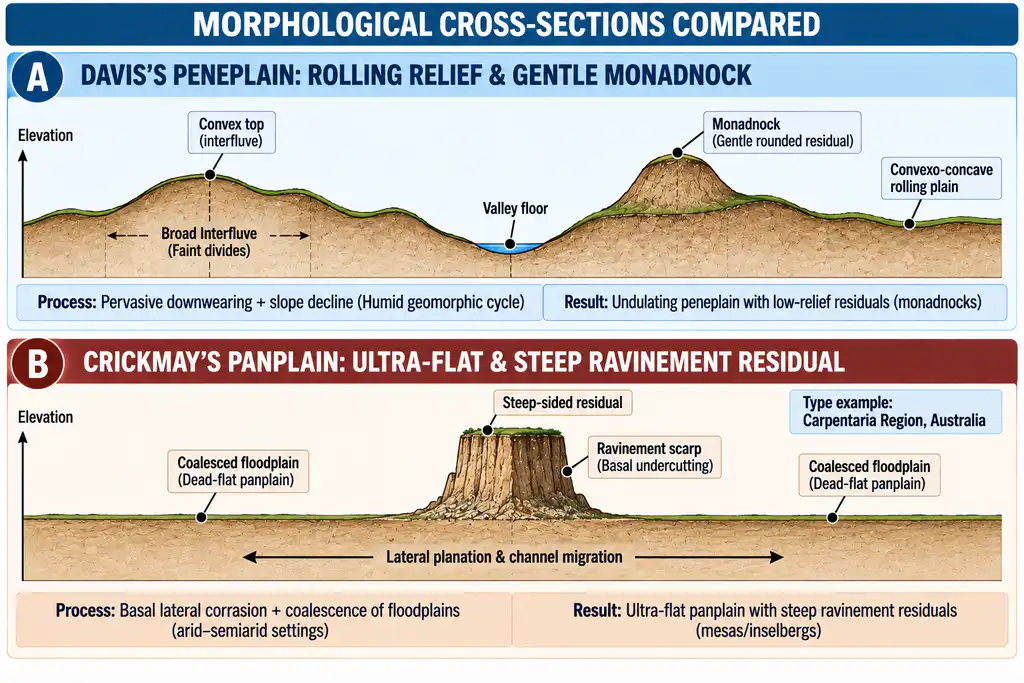
- Morphological Attributes: A subdued, undulating topography with broad, ill-defined interfluves, faint drainage divides, coarse drainage texture, low hydraulic energy, and isolated, smoothly rounded monadnocks composed of resistant bedrock.
2. Comprehensive Critique of the Peneplain Concept
The peneplain concept has been deconstructed across six fundamental geomorphic dimensions:
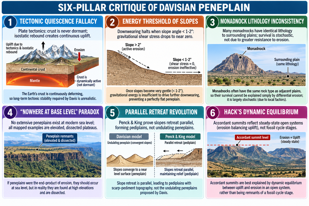
A. The Fallacy of Protracted Tectonic Stillstand & Isostasy
- Plate tectonics and geophysical geodesy demonstrate that continental cratons are never tectonically dead for the tens of millions of years (50 to 100 million years) required for complete Davisian peneplanation.
- Isostatic Compensation: Denudational unloading of continents triggers compensatory isostatic uplift (approx. 80% of eroded rock mass is isostatically compensated by buoyant crustal rebound). Consequently, as a mountain block is eroded, the crust rebounds buoyantly, perpetually rejuvenating stream gradients and preventing the attainment of a terminal base-levelled plain.
B. The Physical Energy Threshold & Limit of Slope Decline
- Davis posited that slopes continue to lower vertically until they flatten into an undulating plain.
- Mechanical Limitation: Gravitational shear stress governing mass-wasting (soil creep, sheetwash) is defined as:Shear Stress = Regolith Density × Gravity × Soil Depth × sin(Slope Angle)
- When slope angle declines below 1° to 2°, gravitational shear stress falls below the critical threshold required to overcome regolith cohesion and internal friction. Mass wasting becomes physically ineffectual. Therefore, slope decline alone cannot flatten an interfluve to base level; slope downwearing asymptotically halts.
C. Inconsistency of Monadnock Lithology
- Davis asserted that monadnocks persist exclusively because they consist of resistant rock.
- Empirical field investigations (e.g., in the Appalachian type-area and the Chotanagpur plateau) reveal that numerous residual mounds consist of the exact same lithology, joint spacing, and structural fabric as the adjacent belevelled lowlands. Their preservation is often a chance product of divide position between widely spaced master streams.
D. The “Nowhere at Base Level” Empirical Paradox
- If the peneplain is the normal evolutionary fate of landscapes, modern continents should display extensive, intact peneplains at sea level.
- In reality, not a single extensive peneplain exists at present base level anywhere on Earth. All claimed peneplains occur as elevated, tilted, or deeply dissected plateau upland surfaces (e.g., Appalachian Schooley surface, Deccan tablelands).
E. Parallel Scarp Retreat & Pediplanation (Penck & King)
- Walther Penck (1924) demonstrated that slope profiles are governed by the ratio of uplift rate to denudation rate (Morphological Analysis), with slopes retreating via parallel replacement.
- L.C. King (1953) established that in arid and semi-arid zones (and arguably globally), scarps retreat parallel to themselves (scarp retreat and pedimentation), leaving behind concave bedrock pediments that coalesce into a pediplain studded with steep bornhardts and inselbergs, rather than a rolling, downwasted peneplain.
F. Rejection of Cyclic Time: Hack’s Dynamic Equilibrium (1960)
- J.T. Hack rejected the cyclic, chronological paradigm entirely. Using the Appalachians, Hack demonstrated that accordant summit heights and uniform valley forms do not represent the fossilised remnants of a completed Davisian cycle.
- Instead, they represent a dynamic equilibrium (steady-state) in an open system, where the morphology of every slope and channel is adjusted to current dynamic processes and rock resistance under active, ongoing uplift.
3. Crickmay’s Revision: The Concept of Panplain
In his seminal papers — “The Later Stages of River Fluvial Erosion” (1933) and “The Work of the River” (1975) — Canadian geomorphologist C.H. Crickmay sought to rescue the concept of a terminal plain by correcting Davis’s flawed slope mechanics.
A. The Thesis of “Unequal Activity”
- Crickmay identified the fatal flaw of Davis, Penck, and King: they assumed geomorphic processes operate uniformly across all slope facets.
- In reality, geomorphic agents exhibit profound spatial inequality of activity. Because slope downwearing stalls on gentle gradients due to the lack of shear stress, weathering mantles on interfluves become inert.
- Effective denudation is overwhelmingly concentrated at the basal channel margins of master streams, where high-velocity water armed with sediment tools actively cuts laterally into the rock.
B. Mechanism: Lateral Corrasion & Floodplain Coalescence
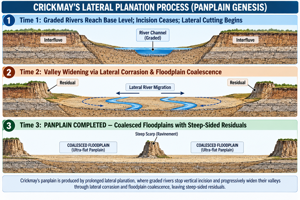
- When a river system attains a graded profile relative to base level, vertical downcutting asymptotically approaches zero.
- The stream’s kinetic energy is redirected entirely into lateral corrasion (meander sweeping) against valley walls.
- As mature rivers continuously sweep laterally across valley flats, valley floors expand and adjacent floodplains coalesce.
- Interfluves are consumed not from above by downwasting, but from the base by lateral undercutting.
- The final morphological product is a continuous, coalesced alluvial-bedrock plain: the Panplain (or Panplane/Planplain).
C. Morphological Contrast: Peneplain versus Panplain
| Morphological Attribute | Davis’s Peneplain (1899) | Crickmay’s Panplain (1933) |
|---|---|---|
| Dominant Formative Process | Vertical downwearing, slope decline, mass wasting | Lateral fluvial corrasion, meander sweeping, floodplain coalescence |
| Topographic Surface Texture | Undulating, rolling, convexo-concave relief | Ultra-flat, featureless, planar topography |
| Residual Hill Morphology | Monadnock: Gently rounded summit, convex top, subdued concave base | Steep-Sided Residual: Sharp, cliff-like boundaries bounded by basal ravinement scarps |
| Primary Physical Agent | Gravity-driven slope wash and soil creep | Hydraulic stream power and corrasion at channel perimeter |
| Sedimentary Association | Residual weathering mantle (saprolite and pedogenic soil) | Thin, extensive veneers of reworked alluvial gravel and sand |
| Canonical Type Area | New England Uplands / Mount Monadnock, USA | Gulf of Carpentaria Lowlands, Queensland, Australia |
4. Critical Appraisal of Crickmay’s Panplain
A. Merits & Conceptual Breakthroughs
- Thermodynamic Realism: Overcame the mechanical failure of Davisian downwearing by anchoring continent-wide planation in the lateral kinetic energy of concentrated streamflow.
- Field Consistency: Accurately accounts for the steep-sided, cliffed residual outliers frequently found abutting mega-alluvial plains.
- Empirical Type Locality: The Carpentaria Plains of Northern Australia — where the broad floodplains of the Flinders, Mitchell, and Gilbert rivers coalesce into an almost dead-flat plain terminating at sea level — provide physical substantiation that Davis’s peneplain lacked.
B. Limitations & Weaknesses
- Underestimation of Interfluve Weathering: Crickmay minimized the role of groundwater sapping, chemical weathering, and pedogenic processes on interfluves.
- Spatial Restriction: True panplanation can only occur in broad, unconfined structural lowlands with high sediment discharge; it cannot operate effectively in structurally locked, incised, or rapidly uplifting bedrock mountains.
- Deep-Time Ambiguity: Once a panplain is uplifted and its alluvial veneer is stripped, its bedrock floor is virtually indistinguishable in the field from a classic peneplain or etchplain, making historical diagnosis difficult.
Conclusion
Davis’s peneplain was a deductive masterpiece that gave geomorphology its initial chronological scaffold, but it foundered upon unrealistic assumptions of crustal stillstand and the physical limits of slope decline. Walther Penck, Lester King, and J.T. Hack decisively demonstrated that slope retreat, pedimentation, and steady-state dynamic equilibrium offer far more accurate descriptions of subaerial slope evolution.
In this intellectual lineage, Crickmay’s panplain stands as a brilliant mechanistic revision. By substituting the physical impossibility of universal downwearing with the empirically observed process of lateral fluvial corrasion and floodplain coalescence, Crickmay provided a viable hydraulic engine for the levelling of continents. While the panplain cannot explain every planated shield, it remains an indispensable model in fluvial geomorphology, explaining the emergence of dead-flat alluvial-bedrock plains across the stable cratonic lowlands of the world.