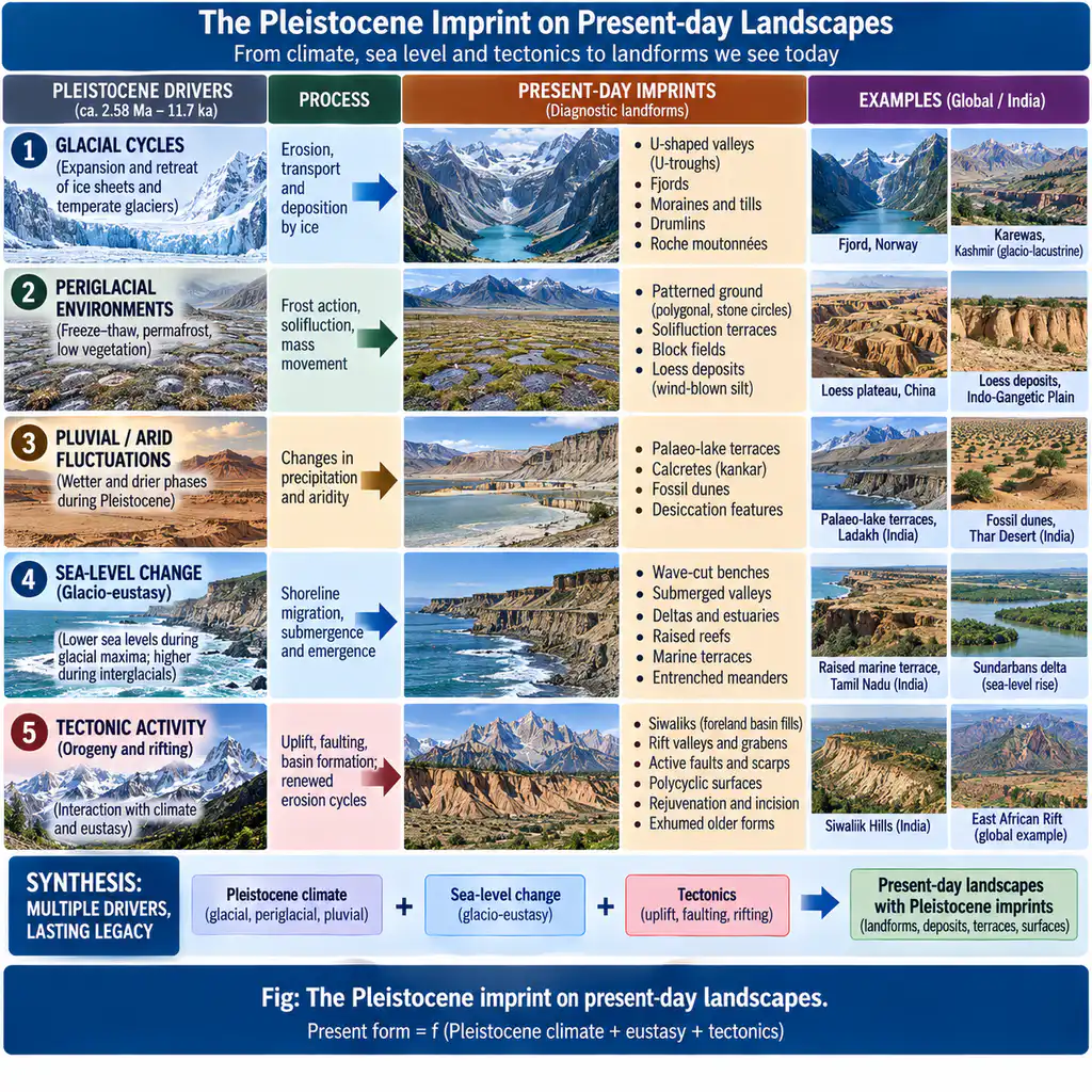
Question: “Proper interpretation of present-day landscapes is impossible without a full appreciation of the manifold influences of the geologic and climatic changes during the Pleistocene.” Discuss.
Introduction: Pleistocene as the Great Sculptor
The Pleistocene epoch (about 2.58 Ma to ~11.7 ka) is the most recent, and arguably the most influential, episode in landscape development. It combined: (i) climatic oscillations — repeated glacial–interglacial cycles, with principal glaciations in Scandinavia/North America, the Alps, and Himalayan and Tibetan glaciers, flanked by periglacial, pluvial and aeolian belts; and (ii) geologic events in progress — continuation of Tertiary orogeny, rifting, and volcanism — atop an unstable, rising crust. Because nearly all present landforms are young (post-Tertiary; largely post-Pleistocene — see Q29), deciphering today’s landscape is possible only through the Pleistocene’s environmental theatre: glacial, fluvial, aeolian, coastal, and tectonic signals are all imprinted in forms still actively adjusting. The statement is correct and fundamental.
1. The Climatic Re-Weighting of Processes
- Four glacial / four interglacial episodes (classical European numbering; more resolved 10+ stadials in modern cycles via the marine isotope stage record) repeatedly shifted the morphoclimatic belts (Q25) across mid-latitudes.
- Global consequences of a glacial maximum:
- High latitudes & mountains — ice sheets and valley glaciers sculpted U-troughs, cirques, horns, roches moutonnées, and produced tills, drumlins, eskers, moraines.
- Periglacial fringe — frost wedging, solifluction, patterned ground, loess accumulation on mid-latitude steppes.
- Pluvial/arid belts at low latitudes — lakes expanded and contracted (Rajasthan/Palaeolake; mega-Lake Chad), dunes mobilised (Thar fossil dunes), rivers changed regime.
- Regional legacy — Europe’s classic tripartite division: till plain → outwash plain → loess (the glacial-fed landscape) is one expression; the Great Lakes, the Baltic, the fjords of Norway are direct glacial legacies.
2. Eustatic and Isostatic Base-Level Changes
- Glacio-eustasy: sea level was ~120–130 m lower at the Last Glacial Maximum (~20 ka), then rose rapidly (~10–15 mm/yr) in deglaciation, and continued (with oscillations) to the present. Imprints:
- Submerged/raised coastal forms: submerged valleys (ria/drowned valleys), drowned river mouths, wave-cut platforms and benches now stranded above or below present sea level.
- Barrier-lagoon systems and deltas initiated on the transgressive shelf — e.g., the Indo-Gangetic delta, Odisha–AP lagoons, Kerala backwaters.
- Coral reef and atoll history records the glacio-eustatic staircase (raised reef terraces of terraces in the tropics).
- Base-level fall during lowstands caused river rejuvenation — incised valleys, entrenched meanders, terraces — transmitting the signal far upstream into the interiors.
- Glacio-isostasy: the crust depressed under ice caps rebounded on deglaciation — Scandinavia still rising ~1 cm/yr near the Bothnian Gulf; raised beaches and lake strandlines (Baltic’s Ancylus–Littorina stages) record the interplay of eustatic rise and isostatic recovery.
3. The Geologic (Tectonic) Changes of the Pleistocene
- Often overlooked under the “awe” of climatic change, the Pleistocene was geologically active:
- Continuing orogeny: the Tertiary fold-mountain building extended into and continued through the Pleistocene — the Siwaliks (Mio-Pleistocene molasse, bounded by MBT and HFT) and the rims of the Pacific Ocean acquired their present configuration; the Himalaya keeps rising, with GPS convergence ~13.6–18 mm/yr across the NW Himalaya and the MFT locked and accumulating strain over ~100 km width.
- Rifting: the Pliocene rifting episode (e.g., East African Rift, Red Sea propagation; the Narmada and Cambay lineaments in India) continued into the Pleistocene, imprinting rift valleys, scarps and drainage reorganization.
- Volcanism: Pleistocene volcanic fields (Andesite Line arc volcanoes, the Deccan’s long-extinct hinterland, continental flood basalts ending) built cones, lava plateaus and calderas still shaping relief.
- Rejuvenation: the tectonic and eustatic instability caused repeated interruptions of erosional cycles — the generation of polycyclic landscapes (Q28) — entrenched meanders, straths, stepped terraces (classic of Himalayan and Indian rivers).
4. Indian Proof: Reading the Present Through the Pleistocene
- Kashmir Valley: glacial, proglacial-lake (Karewa) and fluvial records — the Karewa beds record lake-level changes under Pleistocene climates; terraces and moraines in the Liddar Valley are Pleistocene imprints.
- Siwalik range: Mio-Pleistocene molasse folded/thrusted in the late Pleistocene — a Pleistocene-built frontal ridge; its instability generates the debris-flow and landslide hazards of the present.
- Indo-Gangetic plain: a vast Pleistocene–Holocene alluvial/glacio-fluvial foredeep cover over the peninsular basement; its subsurface alluvial stratification (river shifting — Kosi’s ~133 km westward shift 1736–1968 as a Holocene chapter), palaeo-channels, and Calcretes record base-level and climate change.
- Thar desert: Pleistocene dry phases and aeolian episodes left fossil dunes (Shifting sand sea history); the SUFFERING later fluvial/lacustrine pluvial phases read in playas (Rann, Pushkar).
- Coasts: Khambhat/Gulf and Sundarban histories — the Sundarbans growth after the Holocene transgression; Pleistocene stranding of wave-cut benches and submerged channels of the Narmada–Tapti off Gujarat.
- Modern process as Pleistocene aftermath: today’s high-mountain geomorphic dynamics — moraine-dammed lakes like South Lhonak (formed as the glacier thinned and retreated, expanded 12-fold 1962–2023) — are deglacial (post-LIA/Pleistocene-late Holocene) phenomena; GLOF risk is a Pleistocene-legacy hazard (Sikkim 2023 flood travelled 385 km down the Teesta).
5. The Interpretation Imperative (Why “Impossible Without …”)
- Palimpsest principle: almost every present form is composite — a climatic signal (glacial/periglacial/pluvial) overlaid on a tectonic framework (orogen, rift, basin) with sea-level modulation. Reading the form without partitioning these three imprints is impossible.
- Typifications for the exam — the “Pleistocene checklist”:
- Glacial/periglacial forms in the tropics (Himalaya, Andes, East Africa) — relict from Pleistocene snow-line depression.
- Coastal platforms/reefs/terraces — Eustatic sea-level record.
- River terraces, entrenched meanders, polycyclic surfaces — base-level instability.
- Karewa-type basin fills, loess, fossil dunes — palaeoclimate archives.
- Applied payoff: interpretation is the precondition for hazard reading (GLOF lakes, landslide-prone Pleistocene moraines, erosion-prone unstable regolith) and for Quaternary dating (terrace chronology) — as demanded by the “consequence/hazard clause” of modern PYQ patterns.
6. Conclusion
The statement is entirely correct. The present-day landscape is overwhelmingly a Pleistocene, and post-glacial, production — its glacial, periglacial, eustatic and isostatic forms; its Pluvial and aeolian imprints; its tectonic, rift and volcanic frameworks; and its polycyclic, base-level disturbed river morphology — all set in motion by the multi-scale, multi-proxy environmental changes of the Pleistocene. A “proper interpretation” therefore requires: climatic reconstruction (morphoclimatic geography — glacial/periglacial/fluvial/aeolian belts displaced), sea-level history (glacio-eustasy and glacio-isostasy), tectonic history (orogeny, rifting, volcanism, uplift rates), and geochronology (dating the imprints). Without these four lenses, the Indian plain, the Siwaliks, the Himalayan valleys, coasts and deserts are each uninterpretable — the statement’s “full appreciation of the manifold influences of the geologic and climatic changes during the Pleistocene” is not an option but a precondition of modern geomorphology.