

How are sandspits and tombolos formed? (2019)
- Sandspits and tombolos are depositional ridges of sand or shingle built by waves and currents. A sandspit is attached to the land at one end and ends freely in open water; a tombolo joins an island to the mainland, or one island to another.
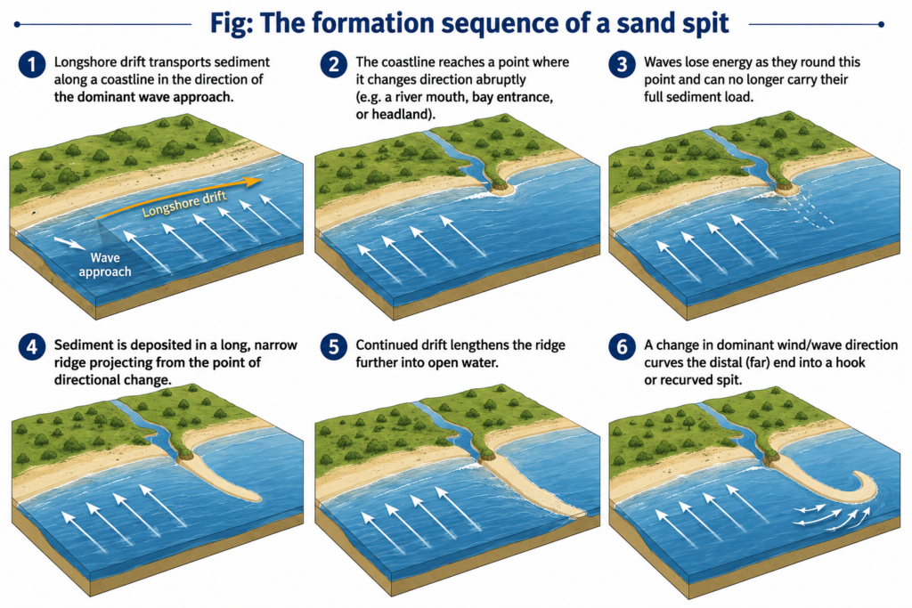
- Both depend on longshore (littoral) drift: waves striking the shore obliquely push sediment up the beach in the swash, the backwash drags it straight down the slope, and the grain zig-zags along the coast in the direction of the dominant waves.
- What differs is where the drifting load is dropped — in open water beyond a bend in the coast (spit), or in the sheltered water behind an island (tombolo).
How Sandspits Are Formed
- Change in coastal direction: where the shoreline turns sharply landward — at a headland, a bay entrance or a river mouth — the drift current carries on in its original direction into deeper, calmer water, loses energy and deposits its load.
- Growth by extension: each increment of sediment lengthens the ridge from the proximal end (attached) toward the distal end (free), so the spit points in the direction of net drift.
- Recurving: waves refracting round the tip, or a secondary wave direction, curve the distal end landward into a hook or recurved spit; several old hooks along one spit record successive stages of growth.
- Back-spit marsh: the sheltered water behind the spit collects fine silt and develops into salt marsh or mudflat.
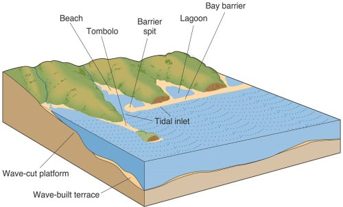
- Further growth: a spit that grows right across a bay becomes a bay-mouth bar, enclosing a lagoon; storm breaching of a long spit can detach a barrier island.
- Indian examples:
- The Kakinada spit, about 21 km long, grew north-eastward from the Godavari delta under strong northeastward drift; its northern end, Hope Island, now shelters Kakinada Bay.
- Dhanushkodi, at the south-eastern tip of Pamban Island, is a drift-built sandy tongue reaching toward Sri Lanka; the cyclone of 22–23 December 1964 destroyed the town on it.
How Tombolos Are Formed
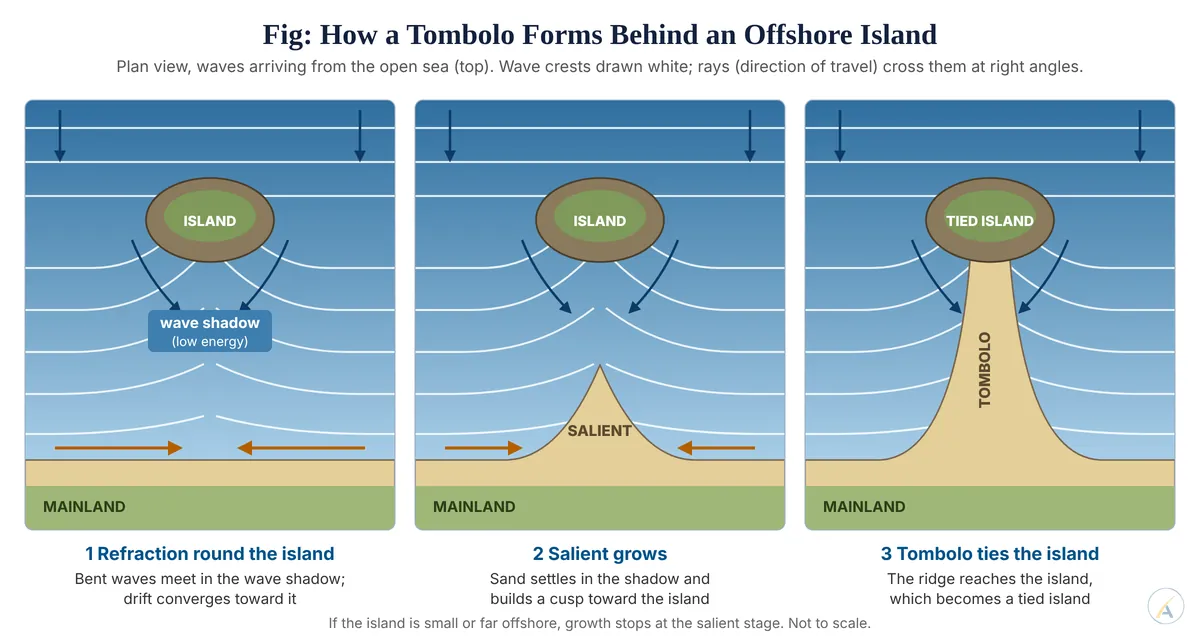
- Wave refraction and diffraction: waves approaching an offshore island bend round both its sides. Behind the island lies a wave shadow where energy is low.
- Convergent drift: the two bent wave trains drive sediment from both sides toward that shadow, where it settles as a cusp of beach called a salient.
- Tying: if the island is large enough and close enough to the shore, the salient keeps growing until it reaches the island, which becomes a tied island. If the island is small or far offshore, growth stops at the salient stage.
- Single, double and tidal tombolos: one ridge is usual; Monte Argentario in Italy is tied by two tombolos (Giannella and Feniglia) enclosing the Orbetello lagoon; some low tombolos are covered at high tide and crossed only at low water.
- A tombolo in position, not origin: not every tombolo comes from refraction. Chesil Beach, which ties the Isle of Portland to the English mainland, is a shingle barrier beach rolled landward by post-glacial sea-level rise, its pebbles since graded by longshore drift.
A Revision from Current Research
- The textbook picture treats Orbetello’s twin tombolos as two spits growing seaward until they reached the island.
- Gilles Brocard and colleagues (2024), using sediment cores, acoustic imaging and radiocarbon, luminescence and uranium–thorium dating, found instead that the two barriers are broad regressive strandplains: they began on the flanks of an older central isthmus when sea level stood about 7 m lower, then grew upward and outward as the sea rose over the last 7,000 years.
- They suggest a double tombolo may be a common but short-lived stage in the growth of a single tombolo — so sea-level history, not drift alone, can decide a tombolo’s form.
Common Controls
- Sediment supply from rivers, cliffs or the shelf; dams that trap river sand starve both forms.
- A dominant wave approach to drive longshore drift.
- Shallow, sheltered water where the load can settle.
- Sea-level change, which can drown, breach or rebuild them.
- Judgement: a sandspit is drift outrunning a bend in the coast, a tombolo is drift converging into the shelter of an island — but current dating work shows that some classic tombolos were shaped as much by sea-level rise as by drift, so both are best read as records of a coast’s sediment budget and sea-level history, not of waves alone.