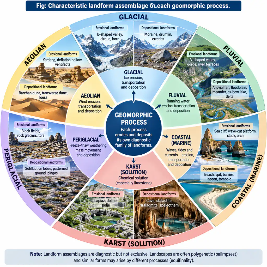
Question: “Geomorphic processes leave their distinctive imprint upon landforms, and each geomorphic process develops its own characteristic assemblage of landforms.” Elucidate.
Introduction: The Process–Form Signature
The statement is the central axiom of process geomorphology: every exogenetic (and endogenetic) process — weathering, fluvial erosion and deposition, glacial, periglacial, aeolian, coastal, karstic, mass movement — engraves a diagnostic morphology on the landscape, and systematically produces a recurring assemblage (a “family”) of genetically related landforms. Recognition of this signature is what allows a geomorphologist to read a region’s formative processes from its present-day forms, and to reconstruct past climates and histories from relict assemblages. The claim is substantially correct — it is the basis of morphoclimatic and process geomorphology — with the caveat that polygenesis, palimpsest and convergent forms (equifinality) blur signatures wherever multiple processes have acted through time.
1. The Principle: Landform = Function of Process
- Process–form linkage: A karst landscape is unthinkable without solution; a drumlin field without glacial ice; a yardang swarm without wind. The specific energy-and-material vector (moving water, ice, wind, waves) imposes a characteristic geometry: size, orientation, slope profile, grain and spatial arrangement.
- Assemblage, not isolated form: processes do not make single landforms — they build systems of related features (a “landform zonal/assemblage”); recognising the ensemble multiplies interpretative power and exam value.
- Two logics govern the imprint:
- Erosion-dominated (zonal/removal) processes → negative landforms (valleys, hollows, depressions, deflation basins).
- Deposition-dominated processes → positive landforms (fans, drumlins, dunes, deltas, moraines).
2. The Characteristic Assemblages — A Diagnostic Table
| Process | Erosional imprint | Depositional assemblage | Diagnostic “signature” |
|---|---|---|---|
| Fluvial | V-shaped valleys, gorges, waterfalls, meander scars, entrenched meanders, badlands | alluvial fans, deltas, floodplains, levees, point bars, ox-bow lakes, terraces, braided bars | dendritic-to-meandering channel network; graded longitudinal profile |
| Glacial | U-shaped troughs, cirques, arêtes, horns, truncated spurs, hanging valleys, roches moutonnées, fiords | till plains, moraines (lateral/terminal/medial/ground), drumlins, eskers, kames, outwash plains, erratics | linear, powerful scouring; subparallel striated ridges; unsorted till |
| Periglacial | blockfields/felsenmeer, asymmetric valleys, cryoplanation terraces, patterned ground | ice-wedge casts, pingos, palsas, solifluction lobes, loess sheets, cambered slopes | permafrost-affected polygonal patterns; deep-sorted materials |
| Aeolian | deflation hollows, yardangs, ventifacts (dreikanter), hamadas, zeugen, rock pedestals | barchans, seif dunes, parabolic dunes, sand seas (ergs), loess sheets, desert pavements | wind-oriented ridges; crescentic dune plan; ventilated, abraded stones |
| Coastal | sea cliffs, wave-cut platforms/benches, blowholes, sea arches, stacks, notches | beaches, bars, spits, tombolos, barrier islands, dunes, cheniers, deltas | shoreline-parallel striping; sediment cell organisation |
| Karst | lapiez/karren, sinkholes, uvalas, poljes, dry valleys, blind valleys | travertine terraces, tufa dams, speleothems (stalactites, stalagmites, helicites, flowstone) | closed depressions; subterranean drainage; terra rossa soils |
| Mass movement | scarp faces, amphitheatre headwalls, debris chutes, arcuate scarps | talus/rock-fall cones, debris fans, rotational slumps with tilted blocks, earth flows, mudflow lobes | arcuate, steep, gravity-dislocated slope zones |
| Volcanic (endogenetic) | calderas, craters, maars | shield cones, stratovolcanoes, lava plateaus, ash sheets, lava tubes, cinder cones | radial drainage on cones; crater-centred annular forms |
3. Process Imprint and Climate: The Morphoclimatic Context
- Zonal vs azonal processes (vital for this question’s full score):
- Zonal processes (weathering, fluvial, aeolian, periglacial, glacial) respond strongly to climate — hence Peltier’s (1950) process–field diagram linking temperature/precipitation to weathering regimes, and Büdel’s (1963) and Tricart’s (1965) morphoclimatic regions.
- Azonal processes (volcanism, tectonism, gravity) operate in every belt; their imprints are superimposed on, rather than displaced by, zonal assemblages.
- Climate-specific assemblages:
- Humid-tropical: etchplains, deep weathering, bombardts, corestones (Büdel).
- Arid: pediments, inselbergs, alluvial fans, lunettes (King’s pediplanation).
- Glacial/periglacial: the striated U-trough assemblage above.
- Semi-arid/mediterranean: badlands, gully networks, calcretes (e.g., Chambal ravines, Deccan traps).
- Consequence: a geomorphologist can assign a palaeoclimate to relict forms — loess + fossil ice wedges ⇒ cold arid past; deep laterites + bombardts ⇒ tropical past. This is the logic of morphoclimatic reconstruction at the heart of Quaternary research.
4. The Imprint in Action: Indian Examples
- Fluvial: Kosi megafan braided channels and avulsion history; Chambal badlands with gully-ravine assemblage.
- Glacial: Kashmir/ Garhwal U-troughs, cirques, lateral moraines; the Pleistocene ice cover of Kashmir’s Liddar Valley; Sikkim’s moraine-dammed South Lhonak lake (formed 12-fold since 1962).
- Arid: Thar’s barchan and longitudinal dunes, ventifacts, Rann of Kutch salt flats (Marusthali assemblage).
- Karst: Meghalaya (Nongkhnum), Borra Caves speleothems in Andhra Pradesh’ Eastern Ghats Cambrian limestone.
- Coastal: Odisha–AP coastal spits and barrier-lagoon systems (Chilika), Kerala’s backwaters, Gujarat’s tidal flats.
- Periglacial: Himalayan altiplanation terraces, permafrost-ice wedges in Ladakh.
5. Caveats: When Signatures Blur
- Equifinality/convergence: different processes can yield similar forms (e.g., a hollow carved by wind vs by salt weathering vs by nivation), undermining unique identification.
- Polygenesis: landforms rarely have one process history; the palimpsest principle (Ollier) means old imprints are overprinted by newer ones — “little of the earth’s topography is older than Tertiary” precisely because later processes re-engraved the surface.
- Relict forms with no current process: a drumlin field records an ice sheet that has vanished; a fossil sand dune in Rajasthan records a drier past (periglacial/aeolian inheritance).
- Morphological convergence by structure: as with Q23, structure can mimic process (fault-line scarps vs glacial steps).
6. Conclusion
The statement is validated by the whole architecture of process geomorphology. Each geomorphic process — through its characteristic mechanisms of weathering, erosion, transport and deposition — impresses a distinctive imprint and generates a characteristic landform family: U-troughs and drumlins for glacial, dunes and yardangs for aeolian, caves and poljes for karst, benches and stacks for coastal, channels and fans for fluvial. This one-to-many signature is the practical basis for landform interpretation, palaeoclimatic reconstruction, terrain evaluation and hazard analysis (e.g., moraine-dammed lake terrains ⇒ GLOF risk in Sikkim). Yet the imprint must be read with care: equifinality, palimpsest polygenesis and structural mimicry mean the modern geomorphologist treats the assemblage as evidence, prudently corroborated by sedimentology, dating and monitoring — not as a deterministic fingerprint.