“Explain how various aspects of channel morphology are used in transportation, settlement and land use planning, flood control and flood management?” (2022)
- Channel morphology — the study of a river channel’s pattern, cross-sectional geometry, gradient, and the sediment-discharge relationships that shape it — is not merely a descriptive branch of fluvial geomorphology; it is the physical basis on which engineers and planners decide where to route a waterway, where to permit settlement, how to zone land along a floodplain, and how much flood protection a given reach genuinely needs.
- The framework that connects channel form to human use is best captured by Leopold and Maddock’s (1953) hydraulic geometry — their finding that channel width, depth, velocity, and sediment load all change as systematic power functions of discharge — together with Lane’s Principle, which states that the product of sediment load and bed grain size is proportional to the product of discharge and channel slope, so that any human interference with one variable inevitably forces an adjustment in the others.
- The thesis argued here: every major channel-morphology parameter — planform pattern, channel structure and the thalweg, hydraulic geometry, sinuosity, and channel stability/migration behaviour — has a direct, load-bearing application in one or more of the five practical domains named in the question, and reading a river’s morphology correctly is therefore a precondition for sound transportation, settlement, land-use, and flood-management decisions, not an optional add-on to them.
Channel Structure and the Thalweg: The Basis for Navigation

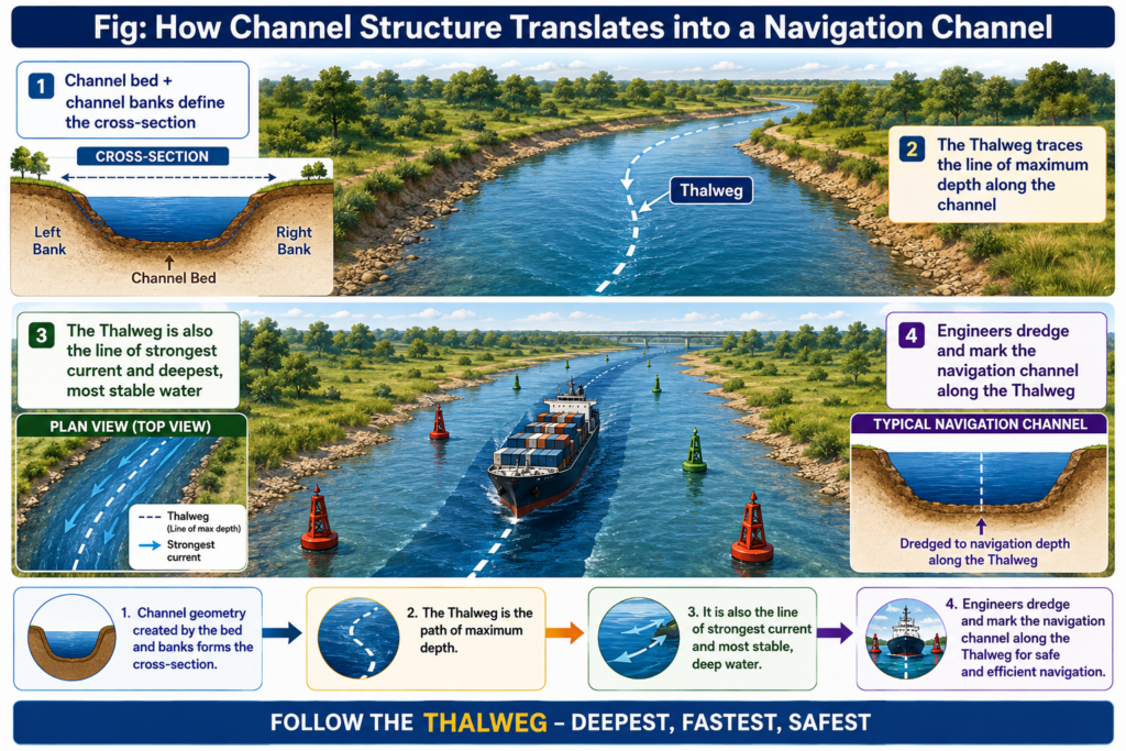
- The Thalweg — the continuous line joining the lowest points along a stream channel — is both the deepest and, generally, the fastest-flowing part of the channel, which makes it the natural line along which shipping channels are dredged, buoyed, and maintained; the legal Thalweg Principle, under which an undefined river boundary between political entities follows the centre of the deepest navigable channel, is itself a direct recognition of the Thalweg’s practical importance for through-traffic.
- Bedrock channels, running through non-erodible material and structurally more stable, provide a channel bed and banks that resist lateral migration, making them comparatively reliable (if occasionally shallow and boulder-obstructed) for fixed navigation infrastructure such as bridge piers and jetties, whereas alluvial channels demand continuous dredging and monitoring precisely because their bed and bank material is erodible and mobile.
- Channel pattern governs the practicability of navigation directly: a single-thread, moderately sinuous channel offers a continuous, predictable deep-water path, while braided channels — dividing and recombining around unstable gravel bars — present shifting, shallow, multiple channels that are notoriously difficult and expensive to keep navigable without continuous training works.
Channel Pattern and Sinuosity: Guiding Route and Settlement Location
- Leopold’s (1957) classic definition of channel pattern — “the plan view of a reach of river as seen from an airplane, including meandering, braiding, or relatively straight channels” — is the starting point for any planning decision that must anticipate how a river will behave over time rather than just how it looks today.
- Sinuosity (the ratio of channel length to straight-line valley length) directly determines how efficiently a transport corridor — whether the river itself or a road/rail alignment running alongside it — can be laid out: a highly sinuous, meandering reach forces a longer, more circuitous alignment and repeated crossings, while straighter reaches permit shorter, more direct routes, which is why road and rail engineers preferentially align infrastructure along straighter reaches or on the outside of stable terraces above the meander belt rather than within it.
- For settlement location, the natural levee — the slightly elevated ridge of coarser sediment deposited immediately alongside a channel during overbank flooding — has historically been the preferred building platform in floodplains worldwide, since it offers marginally better drainage and elevation above the surrounding backswamp while still remaining close to the river for water supply, transport, and fertile alluvium; a very large share of the world’s old floodplain towns and villages, including many along the Ganga plains, are sited on such natural levee crests rather than on the lower backswamp.
- Wandering and braided reaches, by contrast, are actively avoided for permanent settlement precisely because their channel pattern signals frequent, unpredictable lateral migration — settlement planning in such reaches, where unavoidable, is typically confined to demonstrably stable terraces set back from the active channel belt.
Hydraulic Geometry and Sediment Dynamics: Designing for Discharge
- Leopold and Maddock’s hydraulic geometry — width, depth, velocity, and suspended load all increasing as power functions of discharge, both at a single gauging station over time and progressively downstream at mean annual discharge — gives engineers a quantitative basis for sizing bridges, culverts, embankments, and irrigation offtakes to the discharge regime a given reach will actually experience, rather than to an arbitrary fixed dimension.
- Because channel width increases fastest with discharge (historically found to scale roughly as its square root), followed by depth and then velocity, land-use planners can use hydraulic-geometry relationships to predict how much lateral space a channel will occupy at flood discharge and set building setback lines accordingly, well before a flood event actually tests them.
- Lane’s Principle — that sediment load × grain size is proportional to discharge × slope — is the single most important design constraint in channel engineering: any structure or land-use change that alters discharge (such as urbanisation increasing runoff) or slope (such as channelisation straightening a reach) will force a compensating change in sediment transport, commonly manifesting as aggradation (reduced capacity, raised bed, and increased flood risk) or degradation (bank undercutting and infrastructure undermining) if not anticipated in the design.

Channel Stability, Migration, and Land-Use Zoning
- Channel stability — a reach’s propensity for vertical (aggradation/degradation) or lateral (bank erosion/avulsion) movement — is the master variable that land-use and floodplain zoning is built around, because a channel that is actively migrating will, sooner or later, physically relocate beneath whatever has been built too close to it.
- Vertical instability: where sediment supply exceeds transport capacity, aggradation raises the channel bed and increases the width-to-depth ratio, progressively reducing the channel’s flood-carrying capacity — a warning sign planners use to flag reaches needing dredging, sediment-trapping structures upstream, or revised flood-hazard mapping.
- Lateral instability: progressive bank erosion (gradual, driven by aggradation or ordinary meandering) and channel avulsion (a sudden shift to a new course, a sudden re-occupation of an abandoned channel, or a minor braided-channel switch, per Nanson and Knighton’s 1996 three-order classification) together define the channel migration zone — the belt of land a river is likely to occupy at some point over an engineering planning horizon — which forms the technical basis for the “no-build” or restricted-use buffer zones increasingly written into floodplain and riverfront land-use regulations.
- Riparian vegetation, identified as a key dependent variable controlling bank erodibility and near-bank hydraulics, is correspondingly used as a deliberate land-use and flood-management tool: vegetated buffer strips along a channel migration zone slow bank erosion, trap sediment, and reduce the near-bank velocities that would otherwise accelerate lateral instability.
Flood Control and Flood Management: Engineering the Channel Directly

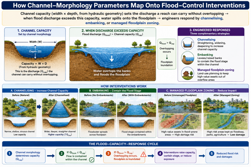
- Channelisation — straightening, deepening, or lining a channel to increase its cross-sectional capacity and hydraulic efficiency — is a direct engineering application of hydraulic geometry: by artificially altering width, depth, and slope, engineers raise the discharge a reach can carry before overtopping, though per Lane’s Principle this also steepens the gradient and typically increases downstream sediment transport and bank erosion, a trade-off flood engineers must explicitly design around.
- Embankments and levees work by containing the flood stage within an artificially raised channel-bank system rather than by increasing channel capacity itself, and their design height and setback distance is calculated directly from hydraulic-geometry discharge-versus-width/depth relationships for the specific return-period flood being planned against (commonly the 25-year, 100-year, or 500-year flood discharge).
- Floodplain zoning, the land-use-planning counterpart to structural flood control, uses the channel’s own morphological behaviour — its historical migration belt, its natural levee and backswamp topography, and its hydraulic-geometry-derived flood extent at various return periods — to classify land into zones of permitted use, restricting the highest-hazard, most flood-prone and most migration-prone belt to low-value uses (agriculture, parkland) while permitting denser development only on demonstrably stable, higher terraces outside the active channel-migration zone.
- Flood forecasting and early warning depend on real-time monitoring at gauging stations that record exactly the same variables — stage, discharge, channel cross-section — that define hydraulic geometry, so that a rise in stage at an upstream station can be translated, via the reach’s known width-depth-discharge relationships, into a predicted arrival time and peak stage downstream, the operational basis of most modern flood early-warning systems.
- Channel morphology therefore functions as the physical vocabulary that transportation, settlement, land-use, and flood-management decisions are written in: the Thalweg and channel structure define where a navigable channel actually lies, channel pattern and sinuosity shape route alignment and settlement siting on natural levees, hydraulic geometry and Lane’s Principle give engineers the quantitative basis to size infrastructure and predict sediment response, and channel stability/migration behaviour defines the hazard belt that floodplain zoning and flood-control structures are designed to manage.
- No single morphological parameter is sufficient on its own — a channel that looks stable in plan view (pattern) may still be aggrading dangerously (hydraulic geometry/Lane’s Principle), and a reach with adequate present capacity may still lie within an active migration zone (channel stability) — which is exactly why comprehensive river-basin planning increasingly integrates all of these morphological aspects together rather than treating navigation, settlement, and flood engineering as separate problems.
- As climate change intensifies rainfall extremes and rapid urbanisation alters runoff and sediment regimes in most of the world’s river basins, understanding channel morphology as a dynamic, adjustable system — rather than a fixed backdrop for engineering works — has become central to sustainable river-corridor management, from the Mississippi to the Ganga-Brahmaputra.