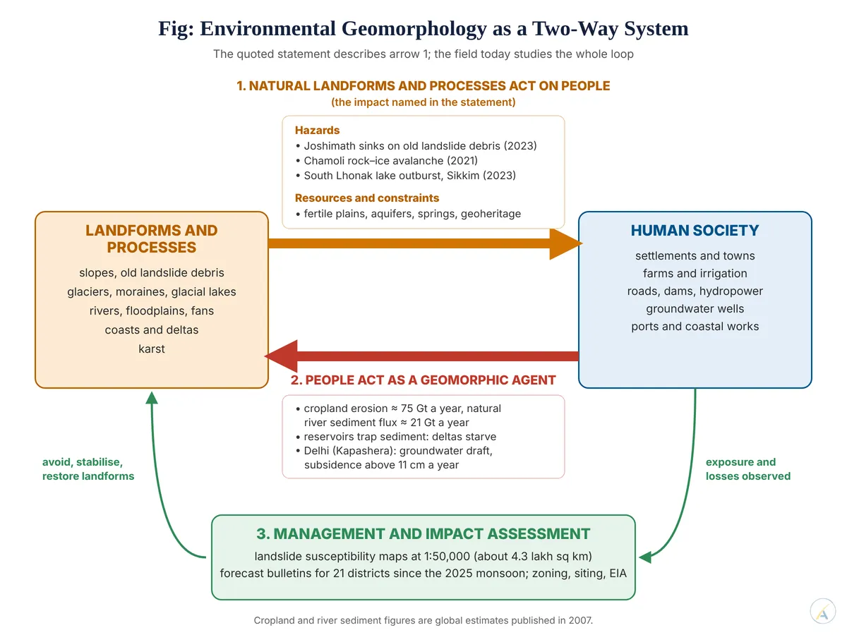
“Environmental geomorphology deals with the impact of natural landforms and processes.” Elucidate with suitable examples. (2026)
The Field and the Statement
- Environmental geomorphology studies the interface between landforms and earth-surface processes on one side and human society on the other — the problems that interface creates and the ways of managing them.
- Donald R. Coates convened the 1970 symposium on environmental geomorphology that gave the field its name; Mario Panizza (1996) organised it around geomorphological resources and geomorphological hazards, their interaction with human activity, and impact assessment.
- The statement captures the field’s founding core: natural landforms and processes affect people — as hazards that damage them and as resources and constraints that shape where and how they live. It names one direction of a two-way relationship.
Natural Processes as Hazards
- Inherited landform as a trap: Joshimath stands on old landslide debris; satellite radar showed it sinking about 5.4 cm in twelve days (27 December 2022 – 8 January 2023) — the landform, not just the building load, set the outcome.
- Process magnitude: on 7 February 2021 about 27 million cubic metres of rock and glacier ice fell from Ronti Peak in Chamoli, turned into a debris flow, left more than 200 people dead or missing and badly damaged two hydropower projects, as reconstructed by Dan H. Shugar and colleagues (2021).
- Process chains: at South Lhonak Lake, Sikkim, on 3 October 2023, about 14.7 million cubic metres of frozen moraine collapsed into the lake, raised a wave of about 20 m, drained some 50 million cubic metres of water and eroded about 270 million cubic metres of sediment that overwhelmed hydropower installations on the Teesta (Ashim Sattar and colleagues, 2025).
- Chronic processes:
- between 1990 and 2018 about 33.6 per cent of India’s coastline was eroding, 26.9 per cent accreting and the rest stable;
- the river island of Majuli has lost a large part of the roughly 1,250 sq km it covered in the early twentieth century to Brahmaputra bank erosion;
- about 12.6 per cent of India’s land area outside snow cover is landslide-prone.
Natural Landforms as Resources and Constraints
- Plains and deltas carry fertile soils and rich aquifers — the Indo-Gangetic plain and the deltas of the east coast hold dense populations for that reason, but the same landforms bring floods and channel shifts, as the Kosi showed when it breached its embankment at Kusaha in August 2008 and moved into an older course.
- Piedmont landforms set land use: on the porous bhabar at the Himalayan foot streams sink underground, and they re-emerge in the marshy terai below.
- Karst supplies spring water but leaks from reservoirs and carries pollution fast.
- Landforms as heritage: distinctive landforms are protected and promoted as geoheritage and geotourism sites — a resource value, not only a hazard.
The Reverse Direction: People as a Geomorphic Agent
- Roger LeB. Hooke (2000) argued that humans have become arguably the premier geomorphic agent, moving earth at an exponentially rising rate.
- Bruce H. Wilkinson and Brandon J. McElroy (2007) estimated farmland denudation at about 75 gigatonnes a year against about 21 gigatonnes for natural river sediment flux — with natural erosion concentrated in the highest 10 per cent of land and cropland erosion in the lower 65 per cent.
- James P. M. Syvitski, Charles J. Vörösmarty, Albert J. Kettner and Pamela Green (2005) showed humans raised river sediment load by about 2.3 gigatonnes a year through soil erosion yet cut delivery to the coast by about 1.4 gigatonnes a year, with over 100 billion tonnes of sediment now held in reservoirs — hillslopes bleed while deltas starve.
- Induced processes: at Kapashera near Delhi airport, groundwater draft drove subsidence of more than 11 cm a year, while Dwarka shifted to slight uplift after curbs on pumping and rainwater harvesting (Shagun Garg and colleagues, 2022).
- The International Union of Geological Sciences declined in March 2024 to adopt the Anthropocene as a formal epoch — but human geomorphic agency is measurable whether or not it is formally named.
Exposure and Management
- Losses grow with exposure as much as with process: Jun Rentschler, Melda Salhab and Bramka Arga Jafino (2022) found 1.81 billion people exposed to one-in-a-hundred-year floods, about 390 million of them in India.
- Management turns the science into action: the Geological Survey of India has mapped landslide susceptibility at 1:50,000 over about 4.3 lakh sq km and, since the 2025 monsoon, issues landslide forecast bulletins for 21 districts.
- The Wayanad debris flows of 30 July 2024, after about 577 mm of rain in 48 hours, struck slopes where deforestation, quarrying and settlement have been cited as aggravating factors — nature’s process and human use working together.
- Judgement: the statement is correct about the field’s core — natural landforms and processes acting on people as hazards and resources — but it is incomplete; environmental geomorphology today studies a coupled system in which people also reshape landforms, and it proves its worth when that understanding becomes siting, zoning, warning and impact assessment.