

Question: Discuss the role of geomorphology in highway construction.
Introduction: Geomorphic Intelligence in Infrastructure Alignment
The feasibility, safety, and operational longevity of highway corridors depend fundamentally on the terrain over which they are engineered. Applied geomorphology evaluates slope kinematics, litho-structural geometry, surface drainage dynamics, and subgrade soil mechanics. Rather than treating topography as a static geometric surface to be blasted or graded, geomorphological analysis treats the terrain as a dynamic, stress-equilibrated system, preventing catastrophic slope failures, subgrade collapse, and expensive chronic maintenance.
1. The Role of Geomorphology Across Diverse Terrains
A. Mountainous and Orogenic Terrains: Slope Kinematics & Landslides
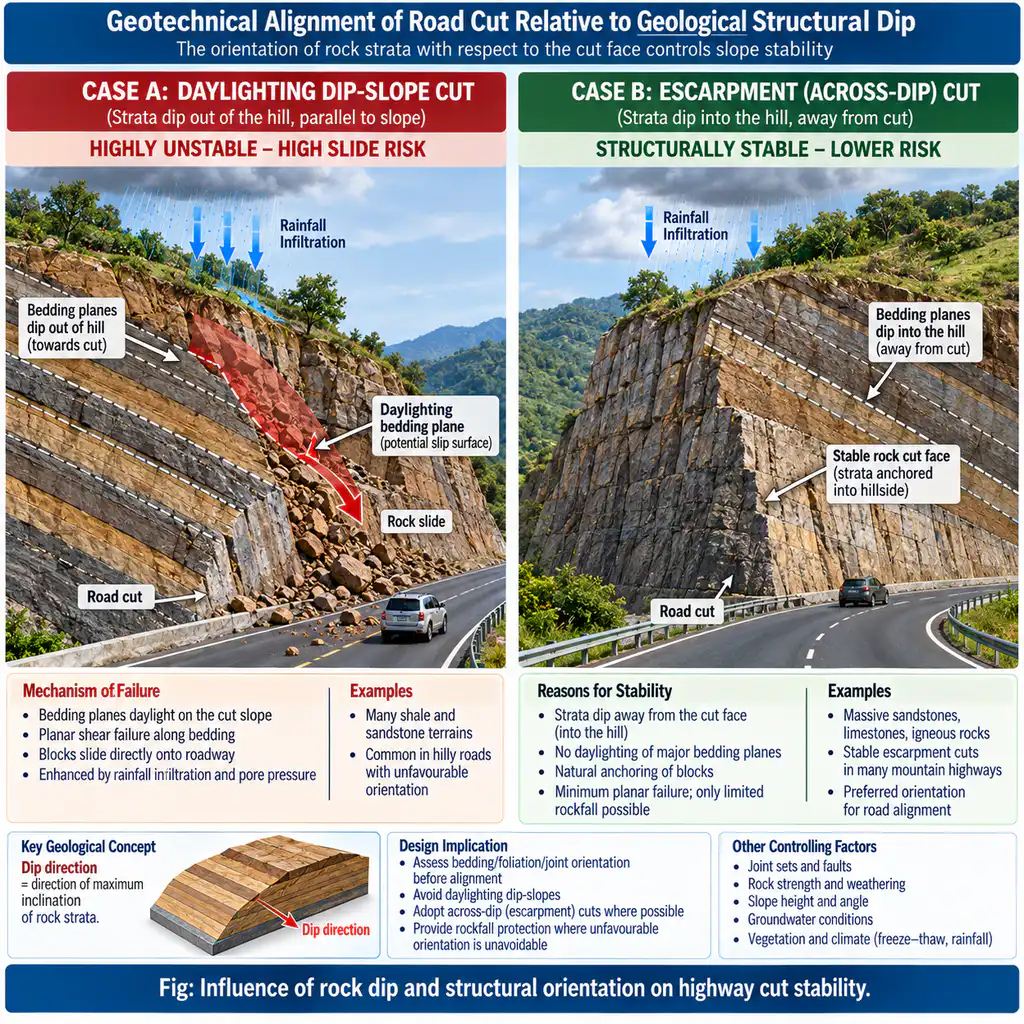
- Structural Dip vs. Cut Slope Geometry: Excavating road benches on slopes where geological strata dip in the direction of the cut (dip-slopes) removes toe support and creates “daylighting” failure planes, triggering massive translational rockslides. Conversely, cuts made on escarpment slopes (cutting across the dip) are structurally self-supporting and far more stable.
- Active Neotectonics and Fault Zones: Highways crossing Himalayan thrust sheets (Main Boundary Thrust – MBT, Main Central Thrust – MCT) encounter pulverized fault gouge and active micro-seismic creep.
- Indian Case Studies:
- Char Dham All-Weather Highway (NH-58 / NH-125, Uttarakhand): Excavations cutting steeply into weathered phyllite and schist colluvium triggered massive recurrent landslides at Chinyalisaur, Helang, and Totaghati.
- Jammu-Srinagar National Highway (NH-44): Recurrent debris slides and shooting stones at Panthyal and Nashri necessitated bypass tunnels through stable bedrock.
- Wayanad Ghat Road (NH-766, Kerala): Heavy monsoon rainfall on colluvial debris mantles over deep weathered laterite profiles triggers chronic debris slides.
B. Fluvial Plains and Floodplains: Drainage and Subgrade “Pumping”
- Cross-Drainage and Bridge Hydraulics: Morphometric analysis of drainage basins using Horton’s and Strahler’s laws of stream ordering determines peak runoff discharge for bridges and culverts, preventing bridge pier scour and roadway washouts during extreme monsoonal surges.
- Subgrade “Pumping” Failure: In low-relief alluvial plains with high water tables, cyclic vehicular wheel loads create high pore-water pressures in fine-grained silts and clays. Silt-water slurry is “pumped” upwards through concrete pavement joints, causing subgrade cavitation and structural pavement collapse. Geomorphological mapping prescribes coarse, well-drained granular sub-base blankets.
C. Karst, Glacial, and Desert Terrains
- Karst Landscapes: Subterranean solution cavities and hidden caverns cause sudden pavement collapse under heavy axle loads. Geomorphological karst mapping (using electrical resistivity tomography and micro-gravity) guides alignment bypasses or deep cavity grouting.
- Glacial/Periglacial Terrains: Well-graded glacial till plains provide excellent aggregate and stable subgrade, while glacio-lacustrine varved clays suffer catastrophic plastic deformation. In permafrost corridors (e.g., Leh-Manali Highway and Zojila pass approaches), seasonal freeze-thaw cycles cause frost heaving and thermokarst thaw subsidence, requiring elevated thermal embankments.
- Aeolian Desert Terrains: Along the Amritsar-Jamnagar Bharatmala Expressway traversing western Rajasthan, highway alignment runs parallel to prevailing barchan migration corridors to avoid transverse sand smothering, supplemented by checkerboard vegetation barriers.
Conclusion
Integrating geomorphological terrain evaluation—combining high-resolution LiDAR, kinematic slope stability analysis, and morphometric watershed mapping—transforms highway planning from an expensive trial-and-error approach into a proactive, climate-resilient engineering discipline essential for sustainable connectivity.