

Question: Discuss the pros and cons of ‘systems approach’ in geomorphology.
Introduction: From Descriptive Cycle to Quantitative System
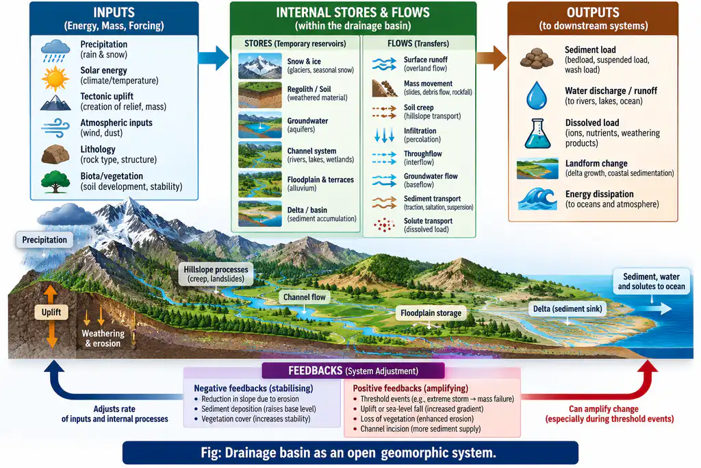
The systems approach entered geomorphology in the 1950s–60s through the quantitative revolution — Strahler (1950, 1952), Leopold & Maddock (1953), Chorley (1962) — treating the landscape not as a pre-ordained Davisian sequence of stages but as a set of interacting components (variables) in which matter and energy flow between stores via fluxes, regulated by feedback. A geomorphic system (e.g., a drainage basin, slope, glacier, coastal cell, aeolian dune field) is described by inputs (precipitation, uplift, solar energy), throughputs/stores (soil, water, sediment, ice), outputs (runoff, sediment yield, dissolved load), and state variables (slope, channel geometry, regolith depth). The approach delivered enormous analytic power — but it also imported assumptions (equilibrium, linearity, stationarity, closed-box thinking) that geomorphology has since debated. The verdict is favourable but conditional: the systems approach is indispensable as a framework, limited as a complete theory.
1. The Core Concepts (What the Approach Supplies)
- System types: closed (no external flux — rare; the Earth’s material cycles approximate it) vs open (energy/material crosses boundaries — e.g., the drainage basin, the beach cell, the valley glacier, are ideal open systems).
- Feedback: negative (self-regulating, e.g., aggradation reduces slope gradient which reduces sediment delivery — dynamic equilibrium); positive (self-reinforcing, e.g., hillslope failure steepens the slope, further failure — leading to thresholds/collapse).
- Equilibrium states: steady-state (inputs=outputs, constant stores), graded (time-transgressive adjustment of a system), dynamic equilibrium (relaxation oscillations about a mean — Hack 1960), static equilibrium (dead storage).
- Thresholds: intrinsic (within-system, e.g., shear strength exceeded → failure) and extrinsic (external, e.g., base-level fall driving incision) — the nonlinearity built into the approach.
- State variables & connectivity: the approach formalises what Davis intuited — that the “details” (slope, channel, store) are interdependent and respond to forcing over characteristic response times.
2. Pros of the Systems Approach
- Quantification & testability: variables (discharge, sediment load, gradient, hydraulic geometry: Q ∝ A^b, exponent laws of Leopold-Maddock for width, depth, velocity) are measurable — hypotheses become falsifiable, ending the descriptive tyranny of the older cycle.
- Linkages and feedback made explicit: the approach exposes pathways (e.g., deforestation → increased runoff → gully incision → base-level fall → knickpoint propagation upstream) that qualitative narrative geomorphology could not formalise.
- Integration across scales: a unified language for the drainage basin, coast, glacier and dune field — the same flux-store-feedback logic applies; ecosystem (lateral) hydrology merges with channel (longitudinal) geomorphology.
- Predictive and applied power: hydrological and sediment-routing models (e.g., using sediment budget/connectivity) support flood prediction, erosion control, dam-sedimentation planning, coastal retreat modelling — the applied geomorphology prized by engineers.
- Handles change and sensitivity: equilibrium and threshold concepts allow analysis of response time and magnitude-frequency (Wolman-Miller): the same event (e.g., a 100-yr flood) has different effects depending on system state — an advance over uniformitarian averaging.
- Accommodates the modern “complex systems” turn: the framework matured into nonlinear dynamical geomorphology — chaos, self-organised criticality (e.g., dune fields and river braiding as self-organising), connectivity/disconnection — the research frontier exploiting the same formal tools.
3. Cons of the Systems Approach
- Pretence of closure: many “open system models” are applied as closed boxes with simple external forcings; real basins are connected to adjacent systems, groundwater, biota, and human interventions in ways the abstraction trims away. Every box is, in truth, an arbitrary incision into a continuum.
- Equilibrium assumption misfires: rigid steady-state/graded assumptions do not fit systems in disequilibrium, non-stationarity or with long memory (e.g., landscapes in transient response to post-glacial adjustment or to rising Himalayan massif); Hack’s equilibrium is a limitation as much as an insight where relief continues to increase.
- Timescale blindness / calibration problem: systems variables measured over monitoring periods (years-decades) cannot simply parameterise process behaviour over cyclic-geologic time (100 ka–Ma) — the Schumm-Lichty “instantaneous-graded-cyclic” scale trap (see Q27).
- Linearity and aggregation: averaging of heterogeneous processes into a few lumped variables obscures spatial non-uniformity (patch-scale variability, sediment routing discontinuities) and can miss tipping behaviour that average-steady models cannot capture.
- Human agency under-theorised: classic systems treat humans as an “external input”; today’s Anthropocene geomorphology shows that human land-system change is internal to the dynamics (urbanized catchments, dams, mining) — systems analysis struggles without a socio-ecological extension.
- Under-determination: the same landform may be produced by different system paths (equifinality); the approach describes dynamics but does not explain the historical uniqueness of form — it needs historical geomorphology alongside.
4. The Synthesis: Systems as Method, Not Substitute
- Modern geomorphology is comfortable with this dualism: systems thinking organises and quantifies (budgets, connectivity, thresholds, response), while historical geomorphology supplies the sequence, inheritance and uniqueness. In practice:
- Dams and river response are analysed as systems (sediment trapping, downstream scour, delta starvation), but their long-run behaviour also requires the historical record (Kosi’s 1736–1968 avulsions).
- Coasts are treated as littoral cells (sediment-celled systems) for sediment management, with the caveat that the cell boundaries shift with sea-level/storm (INCOIS cell-type analyses inform India’s shoreline management).
- The glacial “system” (accumulation → transport → ablation) predicts mass-balance response, while the individual history (proglacial lake growth, moraine breaching) decides hazard (South Lhonak GLOF 2023).
5. Conclusion
The systems approach is a near-indispensable method of modern geomorphology: it quantifies, links and models fluxes, stores, feedbacks and thresholds that descriptive geography could not handle, and it underlies virtually all applied terrain/water management. But it brings recognisable cons: arbitrary closure, equilibrium assumptions that fail in transient and human-managed systems, timescale mismatch, linearisation, and under-determination of unique forms. The mature position treats the two traditions as complementary — systems for dynamics and prediction, historical/denudational study for sequence and identity — precisely the balance the geomorphological synthesis of the last fifty years has achieved, and which the discipline’s own classics (Chorley, Schumm, Hack) always intended.