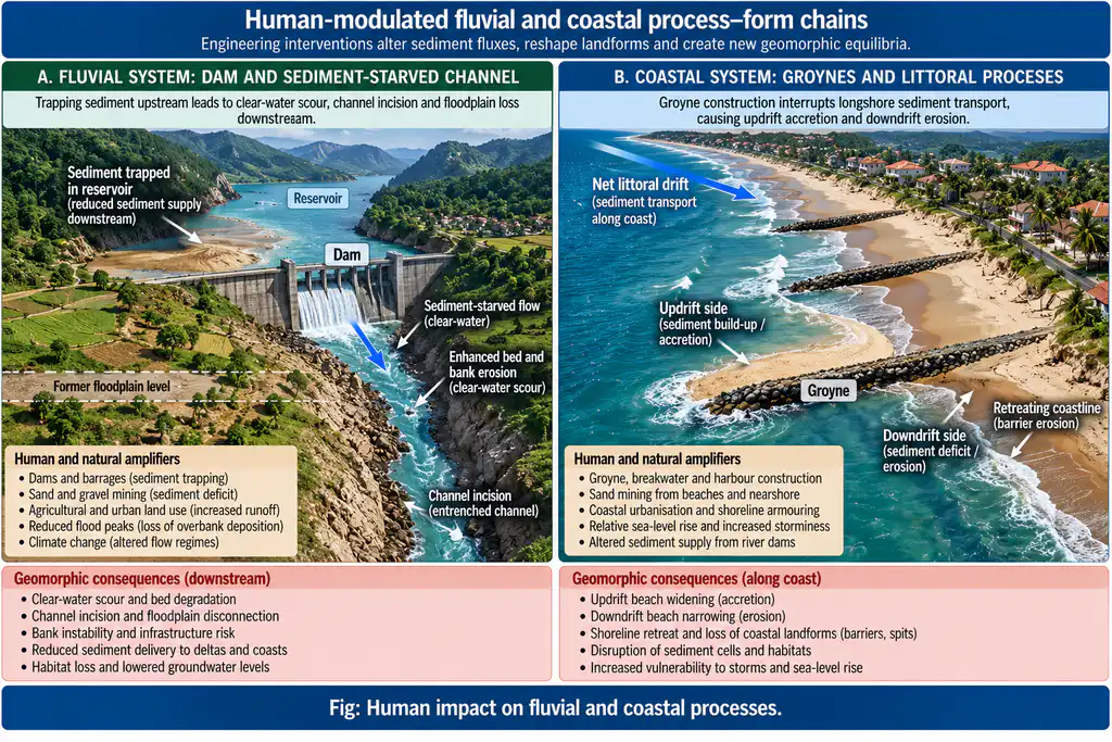
Question: Discuss the impact of humans on: (i) Fluvial processes (ii) Coastal processes.
Introduction: The Human Agent as Geomorphic Agent
Humans have become a geomorphic force comparable in magnitude to natural processes (anthropogenic geomorphology; Goudie, Hooke). River valleys and coasts are the two most densely occupied and most engineered surfaces — hence the deepest anthropic imprints. Impact operates through direct manipulations (structures, extraction, construction) and indirect ones (land-use change, climate forcing, sea-level change); each modifies processes, which in turn redesign landforms in ways that rebound onto society.
IMPACT ON FLUVIAL PROCESSES
A. Direct Impacts: Engineering the Channel and Floodplain
- Dams and reservoirs:
- Upstream: base-level and sediment regime altered — deltas and bay-head deltas form in reservoirs; downstream clear-water erosion scours and incises the channel, degrades the floodplain.
- Sediment starvation: trapping of sediment starves deltas (Kosi–Ganga sediment flux decline feeding delta sinking); the Farakka barrage and upper-Ganga reservoirs have reduced Ganga sediment supply to the Hooghly-Sundarbans system.
- Downstream flood attenuation changes regime; controlled releases flatten the natural flood pulse central to floodplain ecology and channel maintenance.
- Channelization, embankments and levees:
- Straightening, leveeing and groyning increase flow velocity, throw the plan-form into disequilibrium, inhibit natural avulsion — and transfer flood risk downstream (Delhi’s Yamuna bunding; urban culverting of the Kukrail, Bhalswa drains).
- The Kosi embankments (post-1950s) contained a historically avulsing river — yet 2008’s Kusaha breach inundated ~3,000 km² and displaced ~3.5 million — proof that containment re-engineersprocess but not the river’s intrinsic avulsion propensity.
- Sand and gravel mining:
- In-stream bed mining lowers the bed (incision), triggers bank collapse, undermines bridges and structures, disrupts fish habitat, and accelerates delta retreat (pervasive in Indian rivers — Yamuna, Ganga, Cauvery ilegal/mining sites).
- Pumping amplifies the same effect; aggregate mining above bankfull depth increases lateral migration.
- Siltation from land uses: urbanisation (impervious surfaces → flashy hydrographs, higher flood peaks) and deforestation in headwaters (Alaknanda–Bhagirathi/Ganga catchment soil erosion) increase sediment delivery, aggradation and channel instability — the classic Schumm channel-metamorphosis response.
B. Indirect Impacts
- Deforestation/land-use: reduces interception and infiltration, increases overland flow and gully erosion (Chambal ravines, Shiwalik hills); raises sediment yields to the mainstream.
- Irrigation return and industrial discharge: alters water quality, biofilms and discharge dynamics; heavy abstraction lowers flow, concentrating contaminants (Yamuna’s high pollution load).
- Climate forcing (Anthropocene): global warming changes monsoon, flood and drought frequencies — amplifying the fluvial response humans are already imposing (2023 South Lhonak-style cascades, north-India flood intensification).
C. Landform Responses (Geomorphic Consequences)
- Degradation/aggradation switching: downstream incision below dams vs upstream reservoir aggradation; braided–meandering threshold crossing; terraces artificially created.
- Avulsion and delta loss: containing rivers promotes super-elevation and avulsion hazards; delta plains (Ganga–Brahmaputra–Meghna) are losing land (Sundarbans erosion ~50 km² in three decades; Majuli Island shrunk 1,246→~487 km² between 1951 and 2024).
- Groundwater pumping dewatering of alluvial aquifers that support surface flow and riparian processes.
Summary (fluvial): the impact is process-altering and form-generating — humans shift discharge–sediment–width equilibria (Lane’s balance) in both directions, creating new channel gradients, terraces, fan lobes and deltas, and destabilising the very systems on which flood control, navigation and deltaic agriculture depend.
IMPACT ON COASTAL PROCESSES
A. Direct Impacts
- Sediment starvation & hard structures: dams and reservoirs trap river sand; ports, jetties, groynes and breakwaters interrupt littoral drift, causing:
- Updrift accretion and downdrift erosion down-current of structures — the classic “terminal retreat” morphology: e.g., Chennai/Ennore, New Mangalore, Paradip breakwater-induced shore erosion.
- Beach mining and sand removal — facilitates retreat (Tamil Nadu, Kerala beaches).
- Reclamation and land reclamation: filling of estuaries, lagoons and intertidal flats removes attenuation surfaces, changes tidal propagation and estuary form (Mumbai’s reclaimed wards; Kerala backwater encroachments; Visakhapatnam creek fills) — recorded as inverse coastline growth.
- Mangrove and wetland destruction: mangrove removal (Sundarbans fringe; Kerala’s backwater mangroves) removes the natural bio-shield promoting storm-surge wave amplification and accelerated shoreline recession.
- Dredging and navigation: channel dredging of estuarine navigation (Hooghly, Narmada-Tapti entrances) changes tidal prism, estuarine mixing and delta morphology.
B. Indirect Impacts
- Sea-level rise (climate forcing): global mean sea-level ~4.8 mm/yr (2014–2023), roughly double the 1993–2002 rate; along Indian coasts, relative sea-level projections reach 0.62–0.87 m (SSP5-8.5 by 2100) (INCOIS/DOM, 2025), with extreme sea-level rises of 0.68–1.12 m; submergence, erosion, saline intrusion and wetland drowning become endemic (Sundarbans subsidence ~4 mm/yr + SLR — Diamond Harbour rising ~5.7 mm/yr).
- Storminess changes: increasing cyclone intensity frequency rerforms beaches, barriers and dunes more frequently and powerfully (recent cyclonic storm erosion chronologies on Odisha, Andhra, West Bengal coasts).
- Freshwater diversion: reduced sediment and freshwater into deltas (Ganga-Brahmaputra system) concentrates land loss — the systems’ natural accretion is truncated.
C. Geomorphic Consequences
- Shoreline retreat: NCCR monitoring — ~33% of India’s 6,632 km mainland coastline erodes (1990–2018); worst in West Bengal (63%), Pondicherry (57%), Kerala (45%), Tamil Nadu (41%) (1990–2016); Sundarbans blocks (Sagar, Namkhana, Patharpratima) retreating at tens of m/yr locally.
- Barrier–lagoon system reorganisation: inlets migrate, spits breach, lagoons silt (Chilika, Odisha — periodic mouth dredging a symptom).
- Landform creation: artificial islands (filled land), hard-engineered headlands that become new “landforms” of the Anthropocene.
- Adaptive coast-geomorphology: today’s planning (Integrated Coastal Zone Management, NICIS/mangrove regeneration, soft engineering — beach nourishment, sand bypassing) attempts to restore the process balance the earlier engineering broke — ICZM is thus applied coastal geomorphology.
Summary (coastal): humans truncate the littoral sediment budget and water-energy balance — moving shorelines from accreting/stable to erosional regimes — while sea-level rise amplifies every natural and man-made setback; the result is an anthropogenic shoreline whose morphology (trapped littoral cells, artificial islands, degrading barriers) is a direct geomorphic signature of human action.
SYNTHESIS
| Fluvial systems | Coastal systems | |
|---|---|---|
| Principal human levers | Dams, embankments, mining, land use, abstraction | Littoral structures, sediment starvation, reclamation, mangrove loss |
| Process altered | Discharge–sediment–width balance (Lane’s), flood pulsing | Littoral drift budgets, tidal prism, storm attenuation |
| Landform response | Incision, aggradation, avulsion, terrace creation, delta/ fan change | Retreat, barrier migration, lagoon siltation, land loss |
| Rebound on society | Flood/avulsion hazard, navigational loss, groundwater decline | Erosion of cities/ports, saline intrusion, displacement |
| Wise response | Room-for-the-river, dry-weather flow sharing, sediment continuity | ICZM, sand nourishment, mangrove regeneration, soft shorelines |
Humans are, in both realms, the dominant process modifier — but the forms produced are frequently dysfunctional (entrenched, starving, retreating systems). The lessons of applied geomorphology are consistent: preserve process connectivity (let rivers re-work their floodplains, keep littoral cells open), restore sediment budgets, and design soft, adaptive geomorphology — because the Anthropocene landscape will be judged by how well human geometry accommodates, rather than suppresses, natural process.