Question: Discuss the impact of crop cultivation & horticulture on the geomorphic landscape.
Introduction: Farming as Landform-Maker
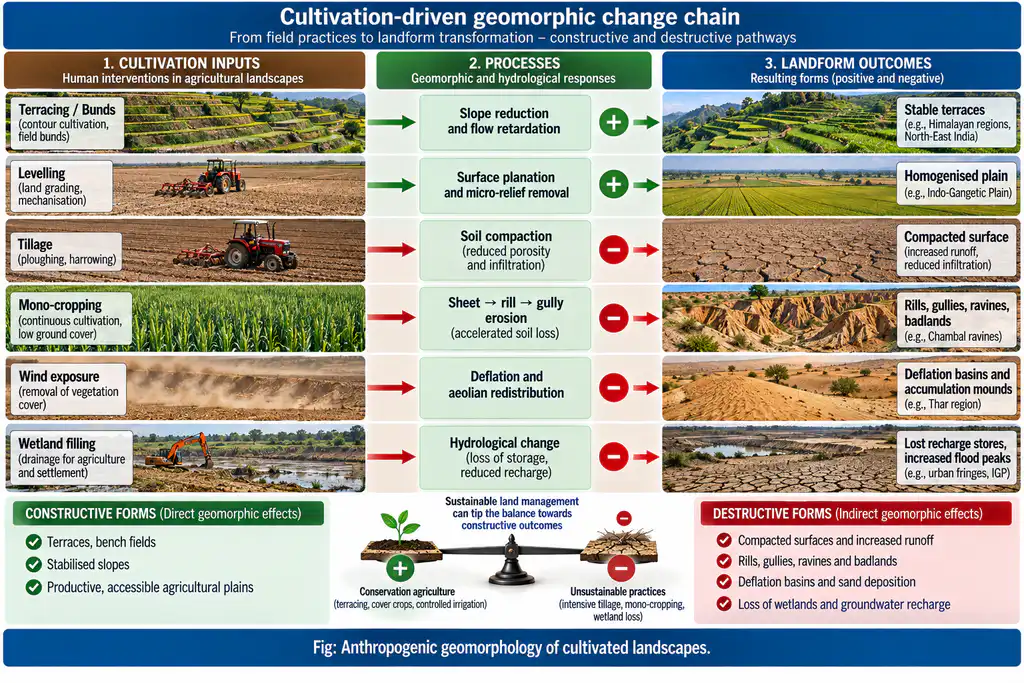
Crop cultivation and horticulture are among the most widespread anthropogenic geomorphic agents: they both create landforms (terraces, bunds, field levelling) and degrade the geomorphic landscape (soil erosion, gullying, surface planation). Their imprint is strongest in plains and gently-sloping terrains — the world’s most intensively farmed basins — but extends to mountains (terracing), semi-arid margins (gullying), and loess belt. The geomorphic impact is two-directional: deliberate reshaping for production (primary landforms) and accidental degradation of process-system balance (secondary landforms). The net signature is an accelerated, homogenised, artificially terraced Anthropocene surface — most visible in India’s Indo-Gangetic plain, Chambal badlands, and Himalayan terraces.
1. Primary Landforms — Deliberate Reshaping of Relief
| Practice | Geomorphic effect | Example |
|---|---|---|
| Terracing | Reduces slope steepness; converts natural slopes into stepped benches with risers; increases arable land and controls erosion | Nepal Himalaya, Western Ghats’ coffee/tea slopes, Sikkim cardamom terraces |
| Contour bunding / rock bunds | Low cross-slope walls intercept runoff, trap sediment — positive constructional landforms for soil conservation | Deccan trap region, semi-arid Chambal margins |
| Field levelling / plot planation | Grades micro-relief to uniform slope; backfills depressions, wetlands, micro-basins | Indo-Gangetic plains, Central European loess belt — former micro-reliefs and ponds homogenised |
| Embankments of paddy fields | Bunds and dykes create a micro-terraced paddy landscape altering micro-topography and water flow | Tamil Nadu, Odisha ancient paddy-field bunding — persistent man-made landforms |
| Irrigation/drainage channels | Ditches, canals and field drains become permanent excavation landforms | Deltaic India (Ganga-Brahmaputra, Cauvery), command areas |
2. Secondary Landforms — Unintended Degradation
- Pseudo-terraces: accidental strip/plot-boundary terraces produced by repeated tillage or plough-turning along plot edges — an inadvertent primary form.
- Excavation–accumulation couplet: topsoil eroded from hillocks is deposited in hollows and ditches — pockets of reworked relief that flatten the landscape.
- Subdued structural forms: agricultural levelling wears down fault-line scarps, constructional terraces and other natural landforms to near-planar surfaces — erasing inherited relief.
3. Process Acceleration: Introduced Imbalances
- Tillage and machinery:
- Soil compaction by heavy machinery reduces porosity and infiltration — lowering slope stability and increasing runoff.
- Slopewise tillage moves soil downslope (tillage translocation), creating rills and minor gullies; plough-ridge alignment can channel flow.
- Dust generation: tilled topless aggregates are wind-erodible — topsoil loss and deflation landforms.
- Water erosion on cultivated slopes:
- Runoff concentration on mono-cropped, bare inter-rows sparks sheet → rill → gully erosion — the Chambal ravines and Deccan trap badland belts are the classic gullyland signatures of cultivation in semi-arid India.
- Headward gully networks expand, connect and form ravines — permanently removing cultivable land.
- Wind erosion and deflation forms:
- Open farmlands without hedgerows expose soils to articulated wind; deflation basins in eroded zones and accumulation mounds along field/canal boundaries form.
- Loess belt degradation: Kazakh/Ukrainian/Chinese loess plateaus — cultivation-induced gullying/ovrag formation; wind+water synergy across the Hungary–Moldova–NW India loess fringe erodes chernozems rapidly.
4. Microclimatic and Pedo-Geomorphic Feedback
- Loss of landscape heterogeneity: removal of tree belts, hedgerows and permanent vegetation raises aridity at the surface (lower evapotranspiration shelter, higher wind speed at soil level), lowers soil moisture retention, and reduces the roughness that retards runoff.
- Humus and nutrient depletion: wind+water erosion strip the nutrient-rich topsoil — soil becomes shallower, less stable, more erodible — a negative feedback amplifying the initial degradation.
- Water-budget alteration: disappearance of ox-bow lakes, wetlands, turfs and depression stores disrupts groundwater recharge and local hydrology, further destabilising slopes and channels.
5. Long-Term Landscape Evolution (Case Frame)
- Karst and Mediterranean: centuries of shallow tillage removed soil cover, exposing bedrock — an irreversible geomorphic threshold crossed — visible in Mediterranean maquis terrains.
- Badlands as terminal state: unchecked gully erosion converts agricultural land into badland (Chambal’s ~4,800 km² ravines; Deccan trap badlands), a landform created by cultivation-plus-mismanagement.
- Loess case study: Hungary/Moldova/NW India — rainfall sheet erosion + spring winds act together to degrade land fast; ovrags/badlands form where management fails.
- Landform diversity loss: intensive monoculture homogenises relief — micro-relief, wetlands, dunes and scrub moraines get planated — so the geomorphic landscape loses information about its natural form.
6. The Counter-Narrative: Sustainable Agricultural Geomorphology
- Conservation agriculture (terracing, contour bunds, field bunds, hedgerows, agroforestry, no-till) restores process balance: capturing sediment, sustaining infiltration, rebuilding organic topsoil.
- Watershed programmes in India (IWMP/Watershed Development Component of PMKSY) re-install bunds and check-dams — effectively rebuilding constructive landforms.
- The geomorphologist’s role: classify slope-hydrology-erosivity to plan location- and terrain-specific cropping — aligning the farming system with, not against, natural process.
7. Conclusion
Crop cultivation and horticulture impress a dual geomorphic signature: constructive reshaping (terraces, bunds, levelled fields, paddy micro-topography — deliberate landform creation that has enabled farming in Nepal Himalaya and the Indo-Gangetic plain) and destructive degradation (soil compaction, wind and water erosion, gully-badland genesis, wetland/hydrological disruption, relief homogenisation — the unintended but pervasive cost). The net landscape is an anthropogenic, homogenised, accelerated-erosion system whose long-run stability depends entirely on management: sustainable, soil-conserving practice creates stable constructive forms; exploitative practice converts farmland into badlands, scars on loess and skeletal, bedrock-stripped soils. The modern imperative — mainstreamed through watershed development and climate-smart agriculture — is to design the geomorphic landscape, using terracing, bunding, cover and compost, so that agriculture creates landforms that hold rather than shed the Earth.