

Discuss the concept of Periglacial cycle as propounded by Peltier. (2017)
- Louis C. Peltier proposed the periglacial cycle of erosion in 1950, applying William Morris Davis’s idea of sequential, stage-wise landform evolution to cold, unglaciated regions dominated by frost action.
- The concept grew out of his climatic geomorphology: Louis C. Peltier divided the world into nine morphogenetic regions (glacial, periglacial, boreal, maritime, selva, moderate, savanna, semi-arid and arid), each with its own dominant processes; the periglacial region he set at a mean annual temperature of roughly −15 °C to −1 °C and 125–1,400 mm of precipitation.
- His claim was that in such regions a distinctive process suite produces a predictable sequence of landforms, ending in a low-relief cryoplain, as William Morris Davis’s fluvial cycle ends in a peneplain.
The Periglacial Setting and Processes
- Permafrost (ground frozen for at least two consecutive years) with a seasonally thawing active layer, usually less than about 2 m thick, sets the rhythm of freezing and thawing.
- Congelifraction (frost shattering): repeated freeze–thaw splits jointed rock into angular blocks.
- Congeliturbation (cryoturbation): frost heave and churning of the active layer, producing patterned ground.
- Solifluction (gelifluction): thawed, saturated debris creeps downslope over frozen ground.
- Nivation: frost shattering and meltwater wash around late-lying snow patches, cutting hollows and benches.
- Seasonal meltwater and wind: rivers flow only in summer and cannot remove all the debris, so valleys aggrade; fine debris is reworked by wind.
The Core Mechanism: Cryoplanation
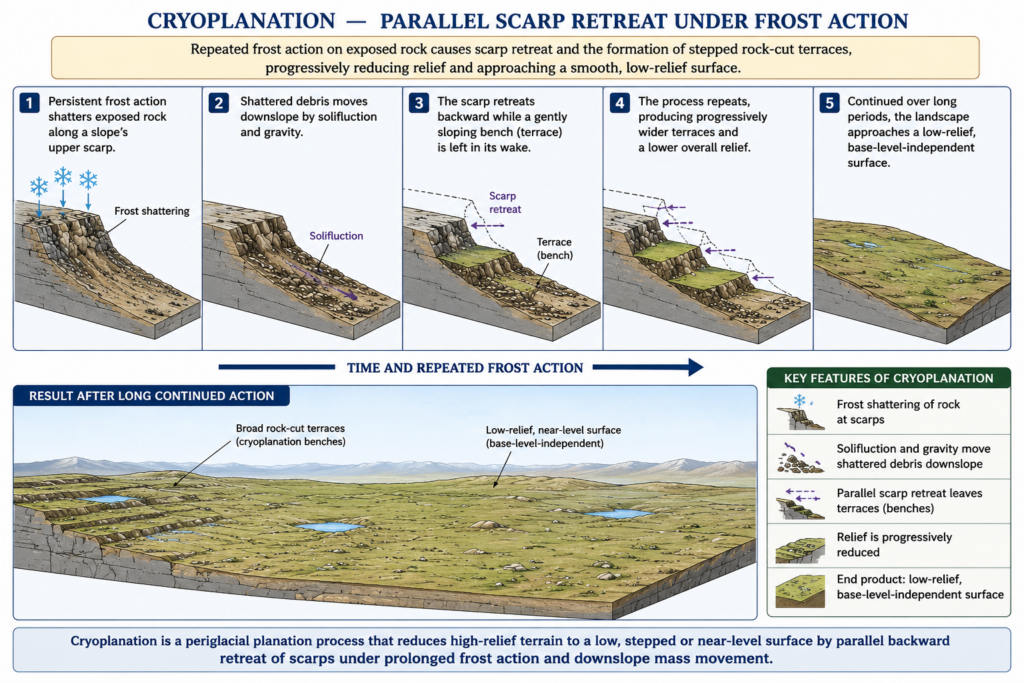
- Louis C. Peltier’s cycle is driven by cryoplanation — planation by frost action — achieved mainly by congelifraction and solifluction.
- Frost-riven scarps retreat parallel to themselves by shattering, while at their foot a gently sloping cryoplanation surface (bench or terrace) is extended, its debris carried away by solifluction.
- The mechanism is the cold-climate analogue of pediment formation by parallel slope retreat in Lester King’s model of hot drylands.
- The end-form, the cryoplain (or altiplain), is a surface of low relief that is not graded to a river base level, because frost action and mass wasting, not river incision, plane the land.
Stages of the Cycle
Initial surface and youth
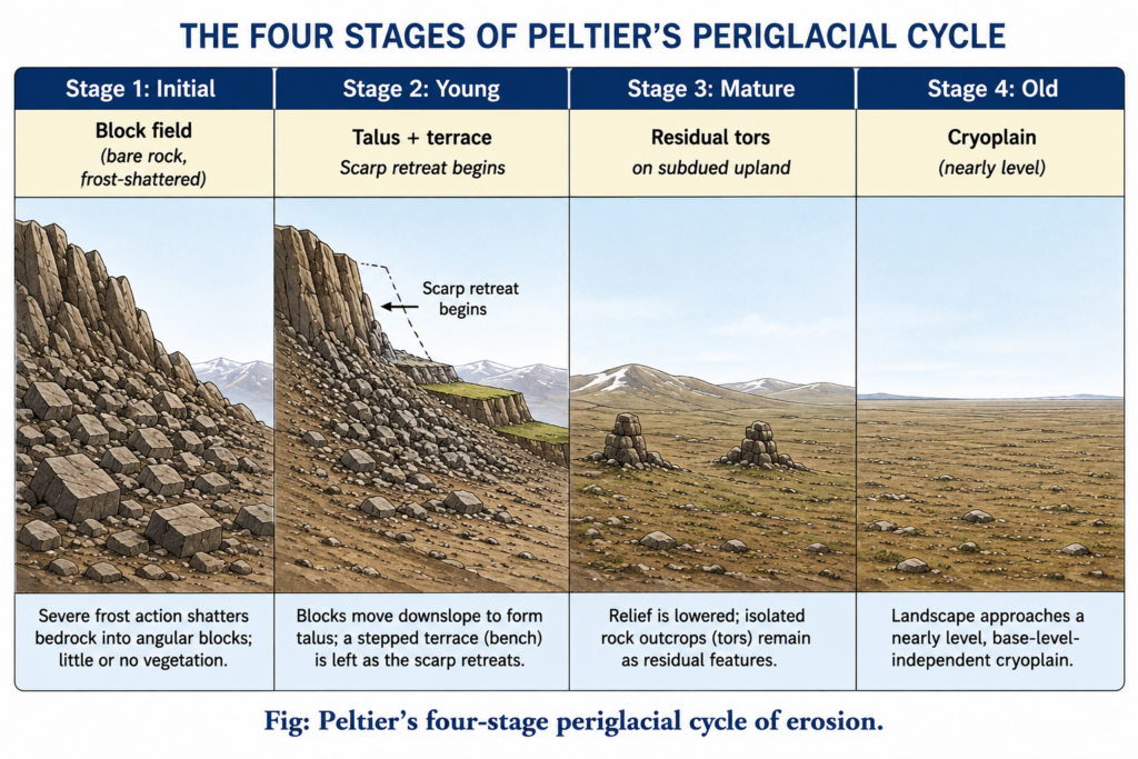
- With the onset of periglacial climate and permafrost, congelifraction attacks bare upper slopes; angular debris accumulates as block fields (felsenmeer) on summits.
- Slopes become steep bare-rock faces with frost-riven cliffs; debris moves down as talus and solifluction sheets, and nivation hollows and small cryoplanation terraces appear on higher slopes.
- Seasonal rivers cannot evacuate the load, so valley floors aggrade.
Maturity
- Continued parallel retreat consumes the scarps and divides; only residual tors and rock remnants survive on summits.
- Cryoplanation surfaces widen and coalesce, and lower slopes and valleys are mantled with frost-shattered, soliflucted debris; the original landscape is largely erased.
Old age
- Interfluves are lowered by congelifraction and gelifluction to gentle slopes; debris is comminuted to finer grades.
- Wind becomes significant: fines are deflated into loess and dunes, leaving ventifacts and lag gravels; rivers can now carry the reduced load.
- The landscape approaches the near-level cryoplain, the periglacial counterpart of the peneplain.
Distribution and Evidence
- Active zones: Alaska, northern Canada, Greenland, Siberia and ice-free Antarctica, and high mountains above the treeline — in India, the cold desert of Ladakh and the trans-Himalaya.
- Jaroslav Obu and colleagues (2019) mapped permafrost under about 13.9 million km², roughly 15% of the Northern Hemisphere’s exposed land, rising to about 22% if the full permafrost region is counted.
- Relict forms — cryoplanation terraces, block fields, tors, solifluction sheets — on the uplands of Britain, the Appalachians and the Carpathians record Pleistocene cold stages, so the cycle doubles as a tool for reading past climates.
Evaluation
Strengths
- Gave periglacial geomorphology a unifying framework at a time when its landforms were described piecemeal.
- Its core idea — frost-driven scarp retreat extending terraces — explains cryoplanation terraces, summit tors, nivation hollows and cryopediments.
- Current research supports that idea: Kelsey E. Nyland and Frederick E. Nelson (2020) found debris on Alaskan terrace treads less weathered close to the scarps, showing the scarps have retreated over time (time-transgressive terrace growth by nivation); Frederick E. Nelson and Kelsey E. Nyland (2017) showed terrace elevations across eastern Beringia rise and fall in step with glacial cirques, pointing to climatic rather than structural control.
Weaknesses
- Louis C. Peltier arranged observed slope forms into a sequence rather than measuring how frost shattering and solifluction shape slopes — the same form-over-process criticism levelled at William Morris Davis.
- Running water — the spring meltwater flood is often the most effective agent in periglacial regions — is under-weighted.
- Pleistocene climates oscillated between glacial, periglacial and temperate phases far faster than a full cycle could run, so a completed cryoplain is rarely possible.
- Colin E. Thorn and Kevin Hall (2002) argued that nivation and cryoplanation are invoked far more often than they have been measured in the field, and that the two should be studied as a single process spectrum.
- Most geomorphologists after 1950 rejected time-bound cyclic models in favour of process–response and equilibrium approaches.
- Judgement: Louis C. Peltier’s cycle survives less as a timetable of youth, maturity and old age than as a process model of cryoplanation; its central mechanism — parallel scarp retreat under frost and nivation — is supported by recent relative-weathering and cosmogenic evidence, and, as permafrost warms, the processes it named are more active, not less.