

Question: “Development of channel pattern is a function of the river dynamics.” Elucidate. (15 Marks)
Introduction: The Fluvial Morphodynamics Paradigm
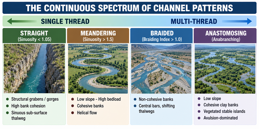
Channel pattern — the planform configuration or map view of a river reach as seen from above — is the most visible, equilibrium-seeking morphological expression of the fluvial engine. First formally classified by L.B. Leopold and M.G. Wolman (1957) into straight, meandering, and braided patterns (later expanded to include anabranching and anastomosing channels), channel planform is not an arbitrary or static structural conduit. Instead, it represents a dynamic equilibrium response between a stream’s hydraulic energy and its sediment boundary conditions.
Under the modern paradigm of fluvial morphodynamics (Chorley, Schumm, and Sugden, 1985), an alluvial river operates as an open thermodynamic system that continuously self-adjusts its planform geometry, cross-sectional shape, and gradient to achieve a dynamic balance between its transport capacity and the sediment flux supplied from its catchment.
As established by Leopold and Maddock (1953), water discharge (Q) and sediment load (Qs) act as the primary independent variables, while width (w), depth (d), velocity (v), slope (S), and channel planform act as mutually adjusting dependent variables.
The development of any channel pattern is thus fundamentally a direct physical function of river dynamics.
1. Theoretical Framework: Dynamic Balances & Governing Principles
The transformation of river dynamics into planform geometry is governed by four foundational physical relationships:
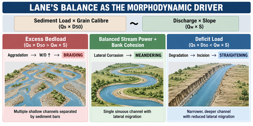
A. Lane’s Dynamic Balance (1955)
Lane’s Principle:
Sediment Load (Qs) × Median Grain Size (D50) ∝ Water Discharge (Qw) × Channel Slope (S)
(In simple terms: Load × Calibre is balanced by Discharge × Gradient)
- Excess Bedload: When sediment supply and calibre exceed transport capacity (Qs × D50 > Qw × S), the stream aggrades its bed, widens, and evolves into a braided channel.
- Deficit Load / High Energy: When stream power exceeds sediment supply (Qs × D50 < Qw × S), vertical degradation and bed incision occur, producing an incised, straight, or entrenched channel.
- Balanced Energy with Cohesive Banks: When hydraulic energy and sediment supply are in balance and banks resist collapse, the channel dissipates excess energy laterally, developing meanders.
B. Schumm’s Sediment-Load & Channel Metamorphosis Concept (1963, 1972)
S.A. Schumm demonstrated that the nature and proportion of sediment load dictate the percentage of silt and clay in the channel perimeter (M-index), directly governing the channel’s width-to-depth ratio (F) and sinuosity (P):
Schumm’s Channel Dimensions:
• M-Index: Percentage of silt and clay in the river perimeter (bed and banks).
• Width-to-Depth Ratio (F): Inversely related to silt-clay content — cohesive banks create narrow, deep channels; non-cohesive banks create wide, shallow channels.
• Sinuosity Index (P): Channel Thalweg Length / Valley Length. Sinuosity increases as bank silt-clay content rises.
| Channel Classification | Silt-Clay Ratio in Banks (M) | Width/Depth Ratio (W/D) | Sinuosity Index (P) | Primary Transport Mode | Planform Response & Behaviour |
|---|---|---|---|---|---|
| Suspended-Load Channel | Greater than 20% | Less than 7 (Narrow, deep) | Greater than 2.1 | Wash load & fine suspension | High-sinuosity stable meandering; slow point-bar accretion, highly cohesive clay banks. |
| Mixed-Load Channel | 5% to 20% | 7 to 25 | 1.5 to 2.1 | Bedload + suspended load | Moderate-sinuosity meandering; scroll bars, alternate pools and riffles. |
| Bed-Load Channel | Less than 5% | Greater than 25 (Wide, shallow) | Less than 1.3 | Rolling, sliding, saltation | Braided multi-thread channel; steep gradient, unstable non-cohesive sandy banks, central braid bars. |
C. Leopold & Wolman’s Slope-Discharge Threshold (1957)
By plotting bankfull discharge against channel slope, Leopold and Wolman identified a critical threshold line separating meandering from braided channels:
Critical Slope Threshold:
Critical Slope (Scrit) = 0.06 × (Bankfull Discharge)^(-0.44)
- Below Critical Slope (S < Scrit): The river possesses lower unit stream power; excess energy is dissipated smoothly by increasing path length through curves → Meandering Pattern.
- Above Critical Slope (S > Scrit): The stream possesses excessive unit stream power; energy overwhelms bank cohesion, initiating lateral scouring, bedload dumping, and multi-thread splitting → Braided Pattern.
D. Unit Stream Power
Unit Stream Power (ω):
ω = (Water Specific Weight × Discharge × Channel Slope) / Channel Width
(Expressed in Watts per square metre — W/m²)
Unit stream power represents the rate of energy dissipation per unit area of the riverbed. When unit stream power exceeds critical thresholds in unconfined, non-cohesive gravels and sands, single-thread channels break down into multi-thread braiding.
2. Physical Mechanisms of River Dynamics Controlling Patterns
A. Helical Secondary Circulation & Meander Morphodynamics
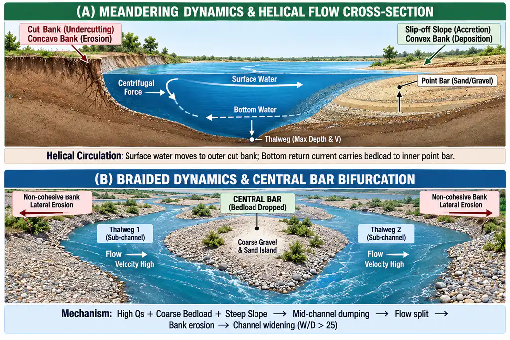
In sinuous and meandering reaches, the development of planform bends is propelled by Prandtl’s secondary circulation of the first kind (helical flow):
- As water traverses a curve, centrifugal force drives fast-moving surface water outward toward the concave outer bank (cut bank), elevating the local water surface.
- A bottom return current develops along the bed, directing slower water inward toward the convex inner bank (slip-off slope).
- This three-dimensional corkscrew flow concentrates hydraulic shear stress on the cut bank, causing undercutting, bank slumping, and lateral channel migration.
- Concurrently, bed sediment carried inward is deposited on the slip-off slope, forming an accreting point bar.
- Continuous bend enlargement increases meander amplitude until the river breaches the narrow neck via a chute cut-off or neck cut-off, abandoning the loop to form a crescent-shaped oxbow lake.
B. Central Bar Accretion & Flow Bifurcation in Braided Channels
In bedload-dominated streams carrying coarse sand and gravel:
- During falling flood stages, the stream’s transport competence drops below the threshold needed to carry coarse bed particles.
- Coarse sediments stall in mid-channel, forming submerged longitudinal diffuse gravel and sand bars.
- The central bar obstructs flow, deflecting high-velocity current filaments outward against both riverbanks.
- Because the banks consist of non-cohesive alluvium, they collapse rapidly, driving substantial channel widening (width-to-depth ratio exceeding 25).
- The broadened, shallow channel experiences an immediate reduction in water depth and shear stress, triggering further mid-channel deposition, multiple bifurcating thalwegs, and complex braiding (measured via Rust’s Braiding Index: total thread length divided by reach length > 1).
C. Avulsion Dynamics in Aggrading Megafans
In piedmont zones with immense sediment delivery, continuous bedload dumping elevates the active riverbed topographically above the surrounding floodplain (channel super-elevation). During major monsoonal floods, the elevated river breaches its levees and abruptly abandons its existing course for a lower gradient path on the floodplain — a process known as avulsion (e.g., Kosi megafan).
D. Anastomosing / Anabranching Patterns (Smith & Smith, 1980; Makaske, 2001)
Distinct from braided rivers, an anastomosing channel consists of multiple, low-gradient, deep, narrow channels separated by stable, semi-permanent, densely vegetated islands or floodplains. It develops in low-energy aggradational environments with cohesive, clay-rich bank material, where avulsion creates stable secondary channels without destroying intervening floodplain islands.
3. Comprehensive Indian Case Studies
A. The Kosi River (Bihar–Nepal): Megafan Avulsion & Metamorphosis
- Draining three immense high-relief Himalayan catchments (Arun, Sun Kosi, Tamur), the Kosi delivers an extraordinary sediment load (approx. 100 million tonnes per year of abrasive sand and gravel).
- Upon exiting the Chatra gorge onto the North Bihar plains, hydraulic gradient drops abruptly from 0.001 to 0.0002, causing rapid bedload dumping.
- Dynamic Response: To evacuate this bedload, the river undergoes continuous braiding and westward avulsion, migrating approx. 140 km westward across its megafan over 250 years (1736–1968) in 12 major avulsion steps.
- The 18 August 2008 Kusaha Breach: Demonstrating avulsion dynamics, the Kosi breached its eastern afflux bund at Kusaha (Nepal), avulsing into paleochannels abandoned over a century earlier, inundating 3,000 km² and displacing 3.5 million people.
B. The Brahmaputra–Jamuna River (Assam–Bangladesh): Megascale Braiding
- The Brahmaputra is one of the world’s most dynamic sand-bed braided rivers, with bankfull discharge exceeding 45,000 m³/s and an annual sediment flux exceeding 735 million tonnes.
- Seismic-Sediment Forcing: The 1950 Great Assam Earthquake (Magnitude 8.6) injected billions of cubic metres of co-seismic landslide debris into the headwater tributaries. This massive sediment pulse caused bed aggradation of up to 3 metres at Dibrugarh, driving severe channel widening and intensifying the Braiding Index.
- Majuli Island Erosion: Decadal satellite telemetry (1951–2024) reveals that approx. 43% of braided channel threads migrate at 150 to 170 metres per year. Consequently, the world’s largest populated river island, Majuli, shrank from 1,246 km² in 1951 to 629 km² in 1975 and down to 487 km² in 2024, engulfing over 100 villages.
C. The Middle Ganga Plain: Active Meandering & Barrage Disruption
- From Buxar to Farakka, the Ganga flows over thick Quaternary alluvium with high bank silt-clay content (M between 25% and 40%), generating classic sweeping meanders, scroll bars, and oxbow lakes (e.g., Kawar Lake in Begusarai).
- Anthropogenic Metamorphosis: Downstream of Farakka Barrage, sediment trapping in the reservoir has altered Lane’s balance (sediment load starved while monsoonal flood discharge passes), driving downstream bed degradation, bank undercutting in Malda and Murshidabad, and local channel straightening.
D. Bedrock-Incised Patterns: Narmada and Chambal Gorges
- Along the Narmada Rift Valley, active Quaternary uplift along the Narmada-Son Lineament (NSL) has steepened hydraulic gradients, forcing the river to carve deep incised bedrock meanders and canyons (e.g., Marble Rocks gorge at Bhedaghat) rather than shifting laterally across an alluvial plain.
- The Chambal Basin exhibits deeply incised meanders with extensive badlands, illustrating how tectonic rejuvenation combined with semi-arid flashy runoff forces entrenched patterns.
Conclusion
Channel pattern is not an immutable geographical given, but a continuously adjusting morphological signature of river dynamics. As demonstrated by Lane’s balance, Schumm’s boundary relationships, and Leopold-Wolman thresholds, rivers operate as self-regulating dissipative systems that organize their planforms — whether straight, meandering, braided, or anastomosing — to optimize the transport of water and sediment within prevailing environmental constraints. Understanding these morphodynamics is indispensable for modern flood hazard zonation, sediment management behind large barrages (e.g., Farakka), and designing sustainable river training and bank stabilization works across India’s dynamic alluvial basins.