

Describe the process of formation of barrier islands and explain their significance. (2025)
- A barrier island is a long, narrow, shore-parallel ridge of sand standing above high tide, separated from the mainland by a lagoon or sound and cut at intervals by tidal inlets — the largest member of the bar–barrier family of depositional coastal landforms.
- A satellite inventory by Matthew L. Stutz and Orrin H. Pilkey (2011) counted 2,149 barrier islands along 20,783 km of the world’s coasts, with the greatest abundance on gently sloping, sand-rich coastal plains of the North Atlantic and the Arctic; Padre Island (Texas, about 182 km) is the longest.
- Indian examples line the east coast: the Rajhansa barrier enclosing Chilika Lake, Sriharikota enclosing Pulicat Lake, and the Kakinada spit of the Godavari delta; on the west coast Vypin fronts the Kochi backwaters.
Conditions Favourable to Formation
- A gently shelving shelf, so that waves break far offshore and drop their load in shallow water.
- An abundant sand supply from rivers, eroding headlands or the shelf floor.
- Moderate wave energy and a low (microtidal) range; strong tidal currents on macrotidal coasts keep sand moving and favour tidal flats instead.
- A slowly rising or stable sea level, which lets the sand body grow upward and roll landward instead of being drowned or stranded.
Process of Formation
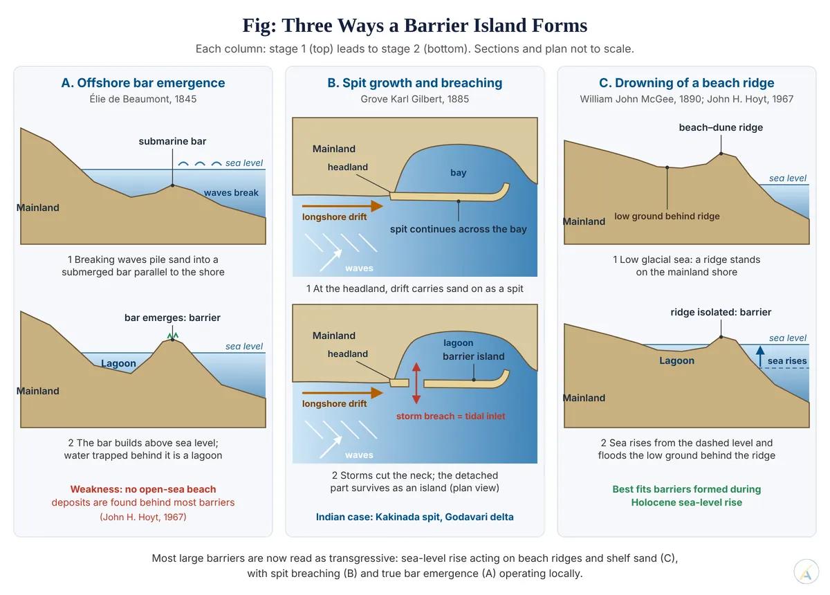
Offshore Bar Emergence — Élie de Beaumont (1845)
- Breaking waves in the shallow surf zone scour the bed and pile sand into a submarine bar parallel to the shore.
- Continued deposition raises the bar until it emerges above sea level; wind then builds dunes on its crest and vegetation stabilises it.
- The water trapped behind becomes a lagoon; storm breaches kept open by tidal scour become tidal inlets.
- Douglas Wilson Johnson (1919) built this into his cycle for shorelines of emergence: submarine bars in the initial stage, emergent offshore bars with lagoons and inlets in youth.
Spit Accretion and Breaching — Grove Karl Gilbert (1885)
- Grove Karl Gilbert argued that barrier sand comes alongshore, not from offshore: longshore drift extends a spit from a headland or river mouth.
- Storm waves later breach the spit’s neck, detaching its distal part as an island.
- The Kakinada spit, about 21 km long, grew north-eastward under strong northeastward drift and deflected a Godavari distributary — the same mechanism at work on the Indian coast.
Submergence of Beach Ridges — William John McGee (1890) and John H. Hoyt (1967)
- William John McGee linked barriers to coastal submergence along the drowned-valley coasts of the eastern USA.
- John H. Hoyt, working from the Georgia coast, found no open-ocean beach or shelf sediments on the landward side of barriers, although a bar that rose offshore must have had open sea, and its deposits, behind it. He proposed that mainland beach–dune ridges were isolated when the post-glacial sea flooded the low ground behind them, turning it into a lagoon.
Weighing the Theories
- The classical association with emergence has not survived the evidence: Matthew L. Stutz and Orrin H. Pilkey found barriers most abundant where late-Holocene sea level was rising, and scarcer where it was stable or falling.
- The modern view is therefore polygenetic: most large barriers formed by Holocene transgression acting on drowned beach ridges and shelf sand, while spit breaching explains drift-fed chains and true bar emergence remains a local case.
Life-History: Landward Rollover
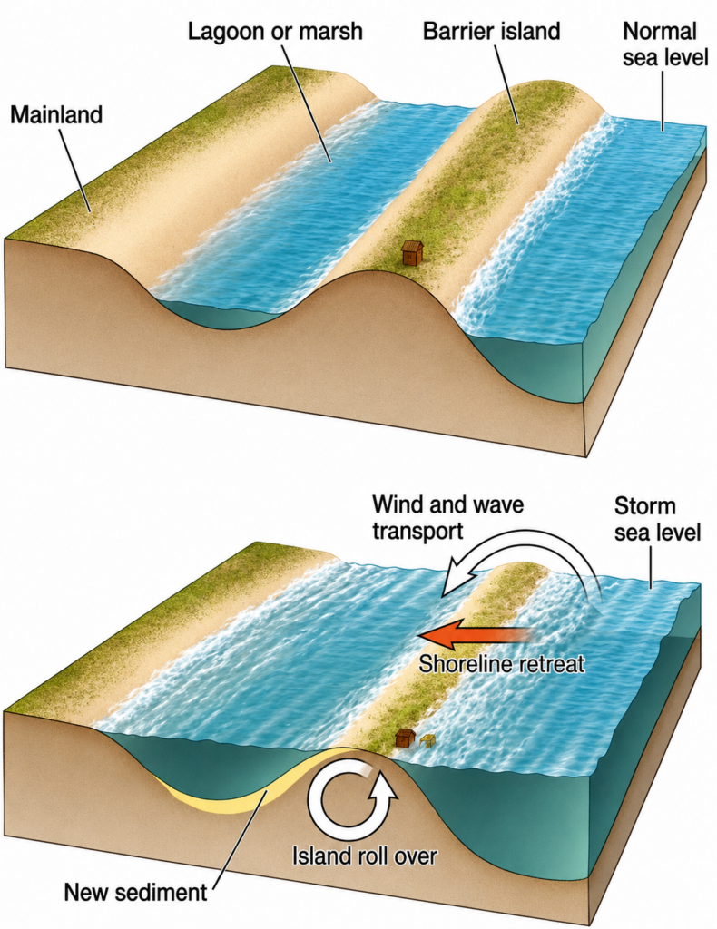
- Once formed, a barrier is never fixed. Storm overwash carries sand from the beach across the island into the lagoon as washover fans, while the seaward face erodes, so the whole barrier rolls over landward — Douglas Wilson Johnson’s “late youth” stage.
- Christopher R. Sherwood and colleagues (2023) showed that Hurricane Dorian (2019) cost North Core Banks on North Carolina’s Outer Banks about 18 per cent of its above-water volume, mainly through floodwater pouring out from the lagoon (sound) side — a mechanism the classical, ocean-side model ignores.
Significance of Barrier Islands
Coastal Protection
- Barriers absorb storm waves and surge before they reach the mainland — a nature-based defence that repairs itself with new sand. Hope Island shelters Kakinada port from Bay of Bengal storm surges, which makes it one of the safest natural harbours on the east coast.
Ecological Value
- The sheltered lagoons are among the most productive coastal ecosystems: fish and prawn nurseries, mangroves and wintering grounds for waterbirds.
- Chilika, enclosed by the roughly 60 km Rajhansa barrier, became one of India’s first Ramsar sites in 1981 and holds a resident population of the endangered Irrawaddy dolphin.
Economic and Strategic Value
- Fisheries, salt pans, aquaculture, ports and tourism depend on lagoon–barrier systems.
- Sriharikota, the barrier between Pulicat Lake and the sea, hosts India’s Satish Dhawan Space Centre.
Management Lessons
- Chilika’s choked, shifting mouth was reopened at Satapada in September 2000; salinity, fish landings and dolphin range recovered — proof that the inlet governs the lagoon’s health.
- Jaap H. Nienhuis and Jorge Lorenzo-Trueba (2019) found that a barrier survives sea-level rise only if overwash and flood-tide deltas keep moving sand landward; jetties and dredged, fixed inlets cut that supply and make the island more vulnerable.
- Dams that trap river sand, such as those on the Godavari, starve the same supply and have already turned parts of the delta coast erosional.
- Judgement: barrier islands are best explained as transgressive sand bodies, not stranded offshore bars, and their significance flows from that mobility — they protect and enrich the coast precisely because they move, so policy should keep sand and inlets free to work rather than pin the islands in place with concrete.