

Describe the “Basket of eggs topography”. (2016)
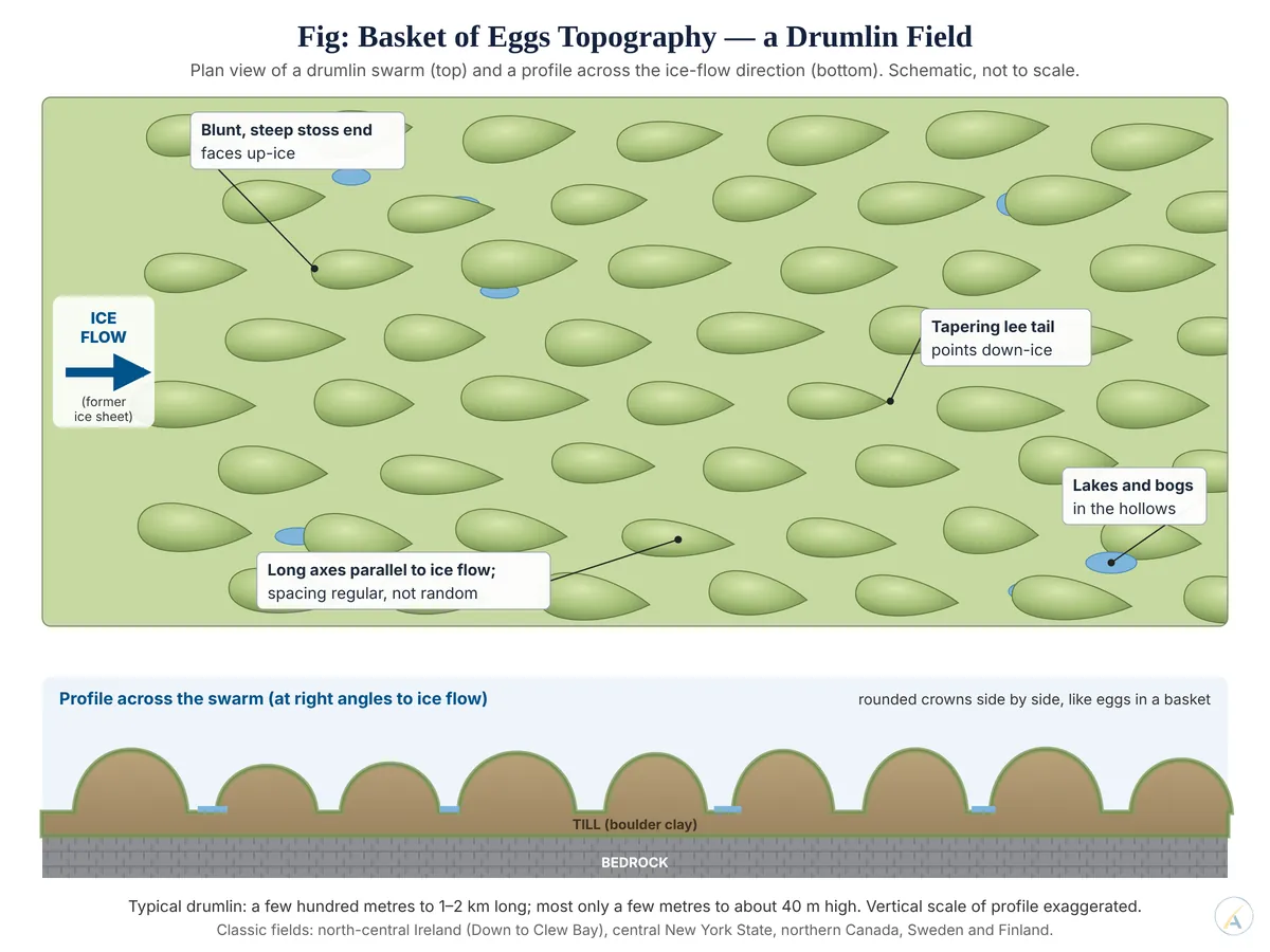
- “Basket of eggs” topography is a lowland landscape studded with drumlin swarms — dozens to thousands of smooth, oval, streamlined hills of glacial till, aligned with the former ice flow, whose rounded crowns seen together resemble eggs packed in a basket.
- The image is old: in 1744 Charles Smith, describing County Down in Ireland, wrote that its small hills were “compared with wooden Bowls inverted, or Eggs set in Salt”. The word drumlin itself comes from the Irish droimnín, “little ridge”, first recorded in 1833.
- The landscape is a diagnostic signature of subglacial streamlining beneath active, sliding ice: its shape records the direction, and even the speed, of a vanished ice sheet.
The Drumlin: Anatomy of the Individual Landform
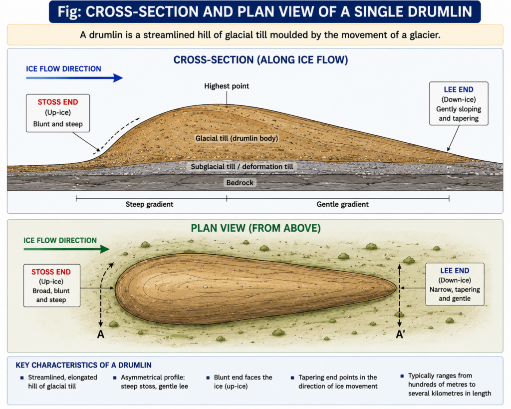
- A drumlin is an elongated, oval or “inverted spoon” hill, composed largely of till (boulder clay), shaped beneath a moving glacier or ice sheet and streamlined parallel to ice flow.
- Size: textbooks quote heights of a few metres to several tens of metres and lengths of a few hundred metres to 1–2 km. Length-to-width ratios generally fall between 1.7 and 4.1; more elongated forms are thought to indicate faster ice.
- Asymmetry: the blunt, steeper “stoss” end faces up-ice and the gently tapering “lee” tail points down-ice, so a geomorphologist can read the ice-flow direction from the shape alone.
- This is the reverse of a roche moutonnée, whose steep plucked face lies on the down-ice side — a classic examination contrast.
- Composition: most drumlins are till-cored; others have a core of bedrock or older stratified sediment wrapped in till (rock-cored drumlins), and some are carved entirely from bedrock.
How Basket-of-Eggs Topography Forms
- Landscape scale: the “basket” appears only when drumlins occur as a field or swarm; one isolated drumlin does not make it.
- Setting: drumlin fields form beneath warm-based, actively sliding ice moving over a soft, water-saturated sediment bed, often near ice margins or in zones of fast flow within ice sheets. Many Pleistocene fields spread out in a fan around the former ice lobe.
- The rival explanations, long debated:
- Deposition: an overloaded glacier lodges till beneath the ice around an obstacle; the mound grows as it slows the ice further.
- Moulding of older drift: advancing ice reshapes earlier moraine or till, eroding the up-ice side and smearing material down-ice.
- Erosion: ice or meltwater removes soft sediment between the hills, leaving drumlins as residual forms.
- Subglacial floods: a minority view that catastrophic meltwater sheet-floods carved the forms.
- Parallel grain: within a swarm the long axes run parallel to one another and to the ice flow, giving the terrain a combed texture on maps and aerial images. Valleys between drumlins hold lakes, bogs and misfit streams, and drainage becomes irregular and deranged.
- Not to be confused with:
- Hummocky (dead-ice) moraine, whose mounds are irregular and unaligned because they formed from stagnant, melting ice.
- Mega-scale glacial lineations — far longer, narrower ridges, typically six to more than ten times longer than wide, formed under fast ice streams. LiDAR mapping of the former Seneca–Cayuga ice stream in New York (2021) shows a continuum from drumlins to such lineations, provisionally read as a record of increasing ice speed.
What Current Research Has Changed
- Self-organisation: Chris D. Clark and colleagues (2017) analysed 42,488 drumlins from Canada, Britain and Norway and found that their spacing is regular, not random, at scales of about 100–1,200 m. Drumlins are therefore read as emergent bedforms, like sand ripples, formed by an instability in the coupled flow of ice, sediment and water.
- Lower relief than the textbooks say: Matteo Spagnolo, Chris D. Clark and Anna L. C. Hughes (2012) measured 25,848 British drumlins from high-resolution elevation data and found an average relief of only about 7 m, with 41 per cent lower than 5 m. The classic “tens of metres” describes the largest, not the typical, drumlin.
- A drumlin field forming today: retreat of Múlajökull, an outlet of Hofsjökull in Iceland, has exposed more than 50 drumlins 90–320 m long and 5–10 m high. Neal R. Iverson and colleagues (2017) modelled them as built by repeated glacier surges, which lay down till sheets, with erosion between surges sculpting the relief — so deposition and erosion both operate rather than one alone.
Global Distribution and the Classic Irish Case
- North America: the largest drumlin fields lie on the bed of the former Laurentide Ice Sheet in Canada; central New York State, between Lake Ontario and the Finger Lakes, holds several thousand drumlins, with others in Wisconsin, Michigan and Massachusetts.
- Europe: Britain, Sweden, Finland, Estonia, Poland, and around Lake Constance in the Alpine foreland.
- Ireland is the type area. A drumlin belt runs from County Down through Armagh, Monaghan, Cavan, Fermanagh and Leitrim to the west coast; its packed hills, small lakes and wet hollows are the archetypal basket of eggs.
- At Clew Bay, County Mayo, the drumlin field has been drowned by post-glacial sea-level rise, leaving hundreds of drumlin islands and islets — the same pattern reproduced as an archipelago.
- Practical significance: impermeable till, poorly drained hollows and broken relief shape farming, settlement and roads. Drumlin crests carry farms and lanes, the hollows hold bogs and lakes, and orientations guide palaeo-ice-sheet reconstruction.
- Judgement: basket-of-eggs topography is best described not as a pile of separately dumped mounds but as a patterned subglacial bedform field — evidence that soft, wet beds beneath fast ice organised themselves into regular hills, so the picturesque label in fact records ice-sheet behaviour precisely.