

Question: Critically analyse the concept of denudation chronology.
Introduction: Defining Denudation Chronology
Denudation chronology is the branch of historical geomorphology that reconstructs the temporal sequence, rates, and mechanisms of subaerial denudation and landform evolution through geological time (S.W. Wooldridge and D.L. Linton, 1955; H. Baulig, 1950; M.A. Summerfield, 1991). Developed during the golden age of classical geomorphology, it seeks to decipher the historical biography of landscapes by addressing three fundamental questions:
- When was a given landscape planated, dissected, or rejuvenated?
- At what rate did denudation and rock uplift operate?
- Which tectonic pulses, glacio-eustatic shifts, or paleoclimatic oscillations punctuated this landscape evolution?
Denudation chronology conceptualizes the Earth’s surface as a geomorphic palimpsest — a composite terrain preserving fragmented, multi-generational records of prior erosional cycles that were interrupted before reaching completion (polycyclic relief).
1. Theoretical Foundations & Evidential Pillars
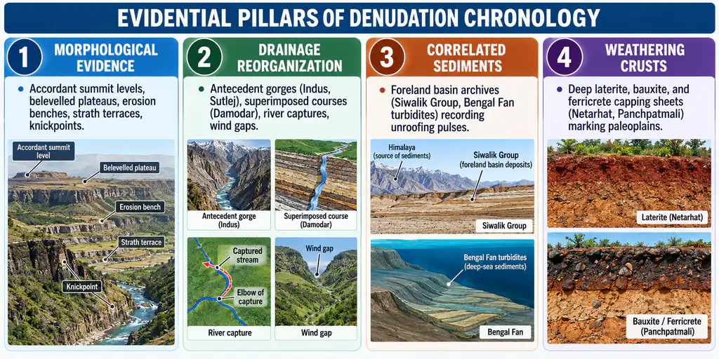
The discipline rests upon foundational geomorphic principles and decodes landscapes through four mutually reinforcing evidential pillars:
- Methodological Uniformitarianism: Operates on the premise that physical and chemical processes observed today have governed the denudational system throughout the Phanerozoic, operating at rates conditioned by prevailing tectonic and climatic boundary conditions.
- Cyclic versus Steady-State Time: While early workers framed evolution within Davisian cyclic time, modern chronologists integrate Schumm’s episodic erosion and Hack’s dynamic equilibrium, viewing landforms as complex responses to threshold crossings.
- The Palimpsest Principle: Most continental landscapes are not monocyclic; they retain physical remnants of ancient denudational surfaces (e.g., Mesozoic or Tertiary paleoplains) alongside modern incision valleys.
2. The Four-Class Evidential Matrix
| Evidential Class | Specific Geomorphic Manifestation | Diagnostic Significance in Landscape Evolution | Indian Field Examples |
|---|---|---|---|
| A. Topographic & Morphometric | Accordant summit levels, bevelled cuestas, valley-side benches, paired river terraces | Identifies former base-levelled planation surfaces now elevated into the upland zone. | Ranchi plateau summit surface (approx. 650 m); Netarhat patland (approx. 1,065 m); Belan Basin erosion levels. |
| B. Drainage Network Analysis | Antecedent drainage, superimposed drainage, stream captures, discordant drainage patterns | Constrains the relative timing between drainage establishment and tectonic uplift. | Antecedent gorges of the Indus, Sutlej, and Brahmaputra; superimposed Damodar and Subarnarekha across Chotanagpur. |
| C. Correlated Sedimentary Records | Foreland basin fills, unroofing sequences, heavy mineral suites, regional unconformities | Provides an inverted stratigraphy: upper sedimentary layers contain debris from deeper crystalline cores. | The Siwalik foreland succession documenting pulsed Himalayan unroofing; Bengal Deep-Sea Fan turbidites. |
| D. Pedological & Weathering Crusts | Deep lateritic bauxites, silcretes, calcretes, saprolite weathering profiles | Marks prolonged subaerial exposure under tectonic quiescence; acts as morpho-stratigraphic horizons. | High-level laterite caps of the Western Ghats (Mahabaleshwar) and Eastern Ghats (Panchpatmali bauxites). |
3. Classical versus Modern Denudation Chronology
The discipline has undergone an intellectual revolution from qualitative narrative deduction to quantitative geochronometry:
| Analytical Dimension | Classical School (Davis, Wooldridge, Linton, Baulig) | Modern School (Burbank, Summerfield, Whipple) |
|---|---|---|
| Methodological Approach | Deductive, qualitative, grand evolutionary narrative | Quantitative, empirical, physical process-based |
| Primary Toolset | Altimetric frequency curves, projected and superimposed profiles | Cosmogenic nuclides (Beryllium-10, Aluminium-26), low-temperature thermochronology, DEMs |
| Dating Capabilities | Relative morpho-stratigraphy, biostratigraphic correlation | Absolute dating (Carbon-14, OSL, Argon-Argon, Apatite Fission-Track, (U-Th)/He) |
| Temporal Scale | Deep geological time (Precambrian to Tertiary) | High-resolution Cenozoic & Quaternary (100 to 10 million years) |
| Primary Focus | Identifying stages of the geomorphic cycle & erosion surfaces | Quantifying denudation and erosion rates (in mm/year) & exhumation |
| Key Weakness | Deductive speculation; gap-filling by assumption; untestable | High analytical cost; limited data for pre-Cenozoic deep time |
4. In-Depth Critical Appraisal
A. Strengths & Explanatory Power
- Historical Synthesis: Converts static topography into a dynamic, historical narrative, explaining why high plateaus exist at elevation, why rivers cut transverse gorges across rising ranges, and why terrace staircases border valleys.
- Coupling Tectonics, Climate, and Landforms: Demonstrates how continental uplift and glacio-eustasy drive exhumation and relief development.
- Applied Geo-Hazard Payoff: Reconstructing denudation chronology provides critical baselines for evaluating neotectonic faults, active seismic zones, landslide hazard risk, and long-term siltation trajectories behind major river dams.
B. Limitations of the Classical School (The Great Critique)
- R.J. Small’s (1970) Fundamental Critique:“An important criticism which has been levelled against the denudation chronology approach is that it succeeds in explaining directly only very small parts of the existing landscape, namely the fragments of former surfaces which have been dissected and almost totally destroyed by more recent erosion.”
Classical chronologists focused disproportionately on planar summit remnants that constitute less than 5% of a landscape, leaving the active valley slopes — where 95% of active geomorphic work occurs — entirely unaddressed. - The Trap of Circular Reasoning: Workers frequently postulated idealised erosion cycles, searched maps for summit spot heights to substantiate the cycle, and then used the assumed cycle to assign ages to the newly identified surfaces.
- Subjective Profile Projection: Morphometric correlation was prone to subjective bias; cartographers routinely drew straight lines connecting distant, isolated mountain peaks to fabricate imaginary regional “peneplains.”
C. Limitations of the Modern School
- The Data-Cost Ceiling: Low-temperature thermochronology (AFT, AHe) and Accelerator Mass Spectrometry (AMS) for cosmogenic nuclides require sophisticated, expensive laboratories, restricting spatial coverage.
- The Deep-Time Horizon: Modern techniques excel at quantifying rates over the last 100,000 to 10 million years, but pre-Tertiary deep-time denudation chronologies remain constrained by stratigraphic gaps and eroded archives.
5. Empirical Testbeds & Indian Field Case Studies
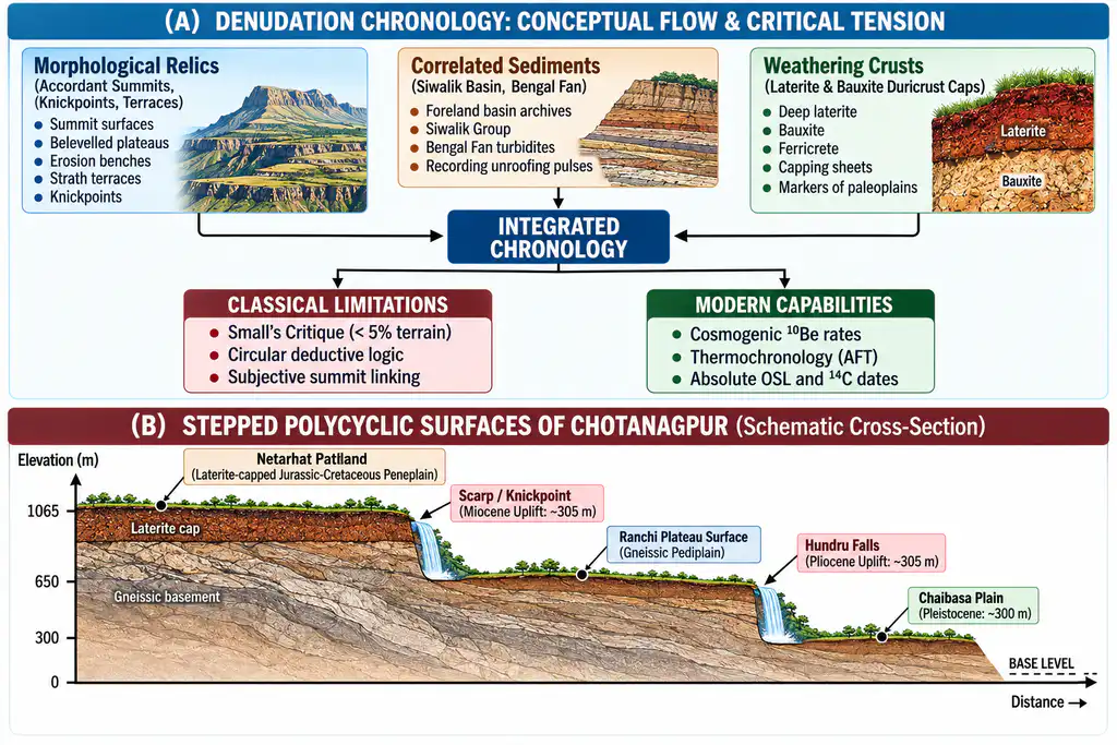
A. The Chotanagpur Highlands Polycyclic Record (Prof. R.P. Singh, 1969)
The Chotanagpur Plateau (Jharkhand) is a global textbook locality for polycyclic denudation chronology:
- Pre-Dalma & Precambrian Surfaces: Archaean folded terrains belevelled and buried beneath Dalma volcanics and Kolhan conglomerates.
- Carboniferous Glaciated Surface: Evidenced by scratched bedrock and glacial tillites preserved at the base of the Talchir coal seams.
- The Gondwana Paleosurface: Jurassic-Cretaceous erosion surface, subsequently capped by Cretaceous Deccan basalt flows.
- Three Tertiary Rejuvenation Pulses: Associated with the distal stress of the Himalayan orogeny:
- Early Miocene Uplift: Uplifted the western plateau by 305 m (1,000 ft), initiating the dissection of the Netarhat Patlands (approx. 1,065 m).
- Late Pliocene Uplift: Uplifted the central plateau by an additional 305 m, forming the Ranchi Plateau (approx. 650 m).
- Pleistocene Uplift: Further pulsed uplift of 215 to 300 m, producing the Chaibasa Plain (approx. 150 to 300 m).
- Rejuvenation Nickpoints: The margins of these uplifted surfaces are marked by prominent waterfalls: Hundru Falls (Subarnarekha, 74 m drop), Dassam Falls (Kanchi, 40 m drop), and Jonha / Gautamdhara Falls (Raru).
B. Modern Himalayan Denudation Chronology: Cosmogenic Nuclides & Thermochronology
Modern isotopic methods have converted qualitative Himalayan chronology into absolute quantitative rates:
- Namche Barwa Syntaxis (Eastern Himalaya): Low-temperature thermochronology and cosmogenic Beryllium-10 (10Be) reveal extraordinarily rapid exhumation and denudation rates of 5 to 28 mm/year, driven by the feedback between intense monsoon river incision and localized tectonic aneurysm.
- Kosi River Catchment: Catchment-wide Beryllium-10 analysis indicates denudation accelerated from 0.12 mm/year at 4.4 million years ago to 4.4 mm/year in the Holocene, proving the coupled intensification of the Indian monsoon and tectonic uplift.
Conclusion
Denudation chronology is an indispensable bridge between static topography and deep geological time. While classical chronologies were legitimately critiqued by R.J. Small and process geomorphologists for their speculative deductive leaps and over-reliance on destroyed relics, modern geochronology and thermochronology have transformed the field into an exact, quantitative science. A contemporary denudation chronology does not rely on deductive cycles alone; it synthesizes classical morphological mapping (to establish the physical skeleton) with cosmogenic nuclides and thermochronology (to calibrate exact rates and ages) — offering an indispensable framework for understanding Earth’s dynamic surface history and mitigating present-day geomorphic hazards.