

“Climate, slope gradient and rock structure influence the avulsion of channels.” Explain. (2017)
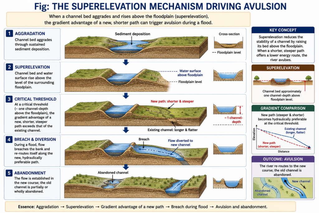
- Avulsion is the relatively sudden diversion of a river from its established channel to a new course across its floodplain, fan or delta — unlike the gradual lateral shift of a migrating meander. The river may cut a new channel, reoccupy an abandoned one, or capture an existing floodplain channel; the switch may be full (old channel abandoned) or partial (flow shared for years).
- Every avulsion needs a set-up — the channel slowly loses efficiency — and a trigger, usually a flood. Climate, slope and rock structure act on one or both, which is why the statement holds.
The Core Mechanism: Superelevation and Gradient Advantage
- Superelevation: when sediment supply exceeds transport capacity, the bed and its levees aggrade until the channel stands above the surrounding floodplain. David Mohrig, Paul L. Heller, Chris Paola and William J. Lyons (2000) found that ancient channels avulsed once superelevation approached about one channel depth.
- Gradient advantage: the raised channel now has a gentler down-channel slope than the slope down its levee flank to the floodplain. Rudy Slingerland and Norman D. Smith showed that a new course takes over when the existing channel’s slope falls to roughly one-fifth of the slope the new path offers. Slope advantage was once treated as sufficient on its own; it is now seen as the second half of a process that superelevation has to prepare.
- Trigger: a flood overtops or breaches the levee, a crevasse splay enlarges into a new channel, or a log or ice jam diverts flow.
Climate: Supplying the Sediment and the Floods
- Sediment supply sets how fast superelevation builds. Monsoonal and semi-arid climates deliver most of the load in a few weeks of high flow; the Kosi brings about 100 million tonnes a year to the plains at Chatara (Rajiv Sinha and co-workers, 2019).
- Discharge variability supplies the trigger: large floods breach levees already primed by aggradation, so avulsions cluster in the wet season.
- Vegetation, itself climate-controlled, binds banks; sparse cover in drier phases makes breaches easier to open and keep open.
- Sea level, a climatic variable, controls delta avulsion. Austin J. Chadwick, Michael P. Lamb and Vamsi Ganti (2020) showed that relative sea-level rise speeds up aggradation and raises avulsion frequency on most large lowland deltas, and can shift avulsion sites inland.
- Long-term change — glacial–interglacial shifts in runoff and sediment yield — can push a whole river system across its avulsion threshold at once, not just one reach.
Slope Gradient: Deciding Where a New Path Wins
- Avulsion concentrates where gradient falls abruptly, because transport capacity collapses there and aggradation is fastest. Sam A. S. Brooke, Austin J. Chadwick, Jose R. Silvestre, Michael P. Lamb, Douglas A. Edmonds and Vamsi Ganti (2022) mapped 113 avulsions in about 50 years of satellite images: on fans they occur where the valley stops confining the river; on deltas they cluster in the backwater zone near the coast — yet 38% of delta avulsions lay farther upstream, in steep, sediment-laden tropical and desert rivers.
- Competing routes: the Atchafalaya offers the Mississippi a much shorter, steeper route to the Gulf of Mexico. Its share of flow rose from under 10% (1850) to about 30% (1950), and only the Old River Control Structure (1963) holds the split at 70:30 — a prevented avulsion. The Mississippi’s delta lobes have switched roughly every 1,000 years.
- On uniform, very low gradients, no single route has a decisive advantage, so flow splits into partial avulsions and anabranching channels rather than one clean jump.
Rock Structure: Setting the Limits
- Confinement: a river in a bedrock gorge cannot avulse, however much it aggrades; avulsion begins where the valley opens. The Kosi’s instability starts just below the Chatra gorge, where it leaves the Siwaliks.
- Bank material: non-cohesive sand and gravel — the Kosi megafan, the North China Plain — erode quickly once breached; cohesive clay or rock banks resist and heal breaches.
- Tectonics: subsidence along a fault lowers one side of the floodplain and steepens the cross-valley slope; tilting or buried basement ridges bias which way the river jumps.
- Artificial structure behaves like geology: levees confine aggradation within the channel and raise it higher. The levee-bound Huang He jumped from a mouth south of the Shandong peninsula to the Bohai Sea in 1851–1855; the Kosi breached its embankment at Kusaha in August 2008 and reoccupied old channels near the centre of its fan.
The Kosi: A Live Debate
- Textbooks describe the Kosi sweeping about 120 km westward in 250 years. Tapan Chakraborty, Rimpal Kar, Parthasarathi Ghosh and Sounak Basu (2010), reviewing 28 historical maps (1760–1960), found the shifts random and oscillating, with a slight long-term eastward bias — not a steady sweep.
- The better reading: climate and slope keep the fan primed, but which channel the river takes next is close to random — so hazard maps should cover the whole fan, not only its west.
- Judgement: the statement is right but incomplete. Climate sets the sediment load and the floods, slope decides whether and where a new path wins, and rock structure decides whether the river is free to take it. Sediment supply and human embankments are the two controls it leaves out, and on the Kosi and the Huang He they have mattered most.