

Attempt a classification of geomorphic processes from the zonal point of view. (2015)
- The zonal point of view belongs to climatic geomorphology: climate, through temperature, moisture and vegetation, decides which processes dominate and so produces a characteristic assemblage of landforms in each climatic zone.
- Julius Büdel (1948) gave the approach its systematic form; Louis C. Peltier (1950) and Jean Tricart with André Cailleux turned it into world classifications of morphogenetic (morphoclimatic) regions.
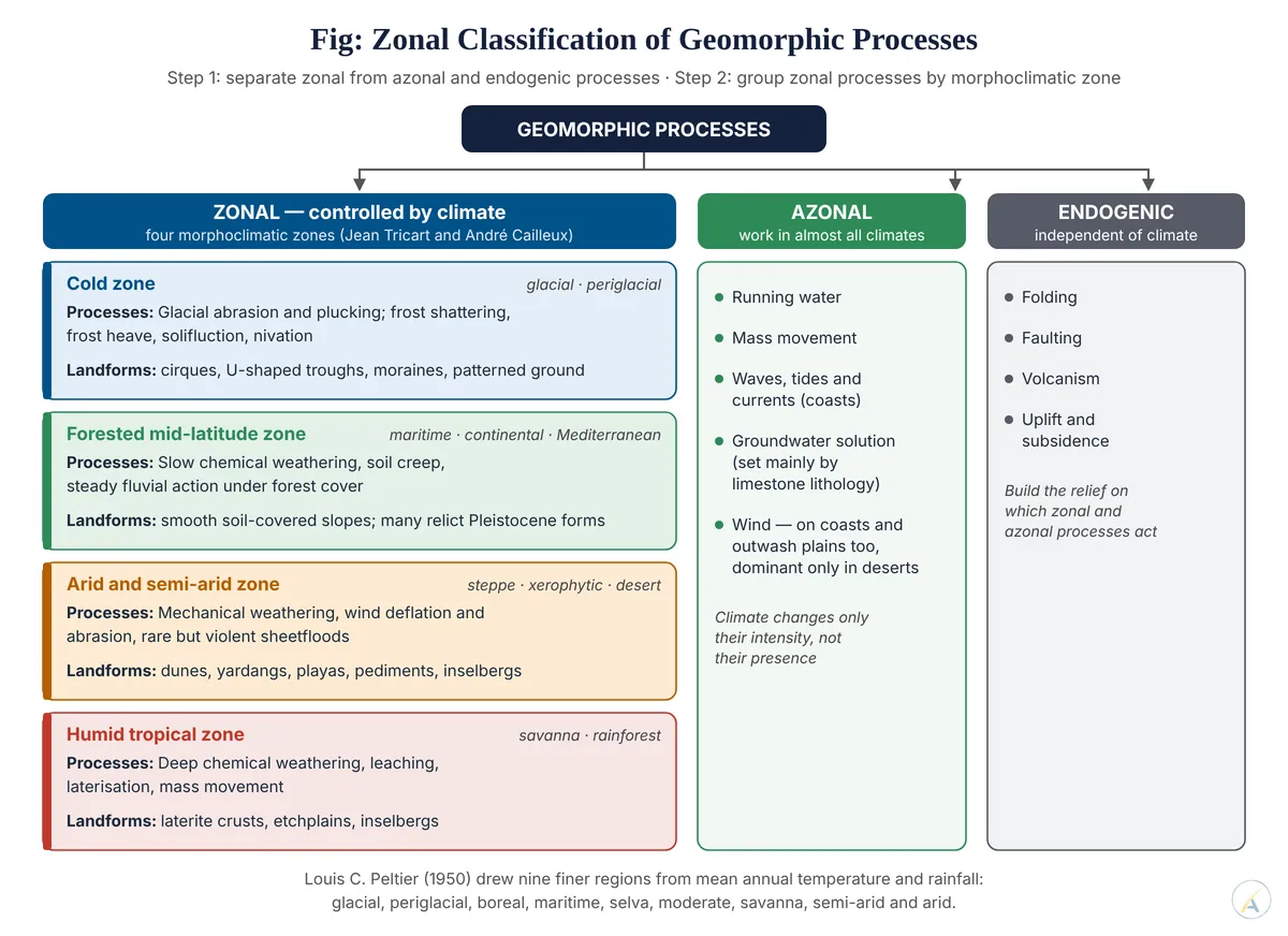
- The first step is therefore to separate processes that are zonal from those that are not.
Step 1 — Zonal and Azonal Processes
- Zonal processes are confined to particular climatic zones:
- glacial erosion and deposition (ice-covered polar and high-mountain zones);
- periglacial frost shattering, frost heave, solifluction and nivation;
- aeolian deflation and abrasion in deserts;
- deep chemical weathering, leaching and laterisation in the humid tropics.
- Azonal processes work in almost every climate, only at different intensities: running water, mass movement, waves and currents on coasts, groundwater solution (governed more by limestone lithology than by climate) and wind, which shapes coastal dunes and periglacial loess but dominates only in deserts.
- Endogenic processes — folding, faulting, volcanism — are wholly independent of climate.
Step 2 — Classifying the Zonal Processes by Morphogenetic Region
Louis C. Peltier’s Nine Regions (1950)
- Louis C. Peltier plotted mean annual temperature against mean annual rainfall and rated the intensity of chemical weathering, frost action, mass movement, wind action and running water in each field.
- He identified nine regions: glacial, periglacial, boreal, maritime, selva, moderate, savanna, semi-arid and arid — quantitative and mappable, but bounded only by climatic averages.
Jean Tricart and André Cailleux’s Four Zones
- They added vegetation and palaeoclimate to climate, recognising four major zones, each divided into sub-zones:
| Zone | Sub-zones | Dominant processes | Typical landforms |
|---|---|---|---|
| Cold | glacial, periglacial | glacial abrasion and plucking; frost shattering, solifluction | cirques, U-shaped troughs, patterned ground, block fields |
| Forested mid-latitude | maritime, continental, Mediterranean | slow chemical weathering, soil creep, fluvial action | smooth soil-covered slopes; many relict Pleistocene forms |
| Arid and semi-arid | steppe, xerophytic, desert | mechanical weathering, wind deflation, episodic sheetfloods | dunes, playas, pediments, inselbergs |
| Humid tropical | savanna, rainforest | deep chemical weathering, leaching, mass movement | laterite crusts, etchplains, inselbergs |
Julius Büdel’s Contrast of Extremes
- Julius Büdel set a polar zone of excessive valley-cutting against a tropical zone of excessive planation, where a deep weathering front and a surface of wash lower the land together — his double planation surfaces.
Altitudinal Zonation and Indian Examples
- High mountains repeat the zones vertically: fluvial processes on the lower Himalayan slopes, periglacial frost action above the treeline, glacial processes above the snowline.
- India spans several zones: aeolian Thar, cold-desert Ladakh (periglacial and wind action together), laterite-forming Western Ghats and Meghalaya plateau, and monsoonal savanna processes over much of the Peninsula.
Step 3 — Limits of the Zonal View
- Charles Rowland Twidale and Yannick Lageat (1994) argued that only the glacial, periglacial and arid zones carry clearly diagnostic landforms; elsewhere climate–landform links are weak.
- Inheritance: Pleistocene periglacial forms survive in temperate Europe, so present climate does not explain all present landforms.
- Structure and tectonics can override climate — a fast-rising mountain front in the tropics is dominated by incision and landslides, not planation.
- Current work shows zonal effects are real but non-linear: Jessica Starke, Todd A. Ehlers and Mirjam Schaller (2020), using 86 cosmogenic-nuclide erosion rates along 3,500 km of the Andes, found that more vegetation lowers erosion in dry zones but goes with higher erosion in wet, densely vegetated ones.
- Judgement: a sound zonal classification has two tiers — first zonal versus azonal and endogenic processes, then the zonal processes grouped into cold, forested mid-latitude, arid and humid tropical regions; it predicts well at its cold and dry extremes but must always be checked against inheritance and structure.