Question: “An appreciation of world climates is necessary to a proper understanding of the varying importance of the different geomorphic processes.” Elucidate.
Introduction: Climate as the Master Variable of Process Geomorphology
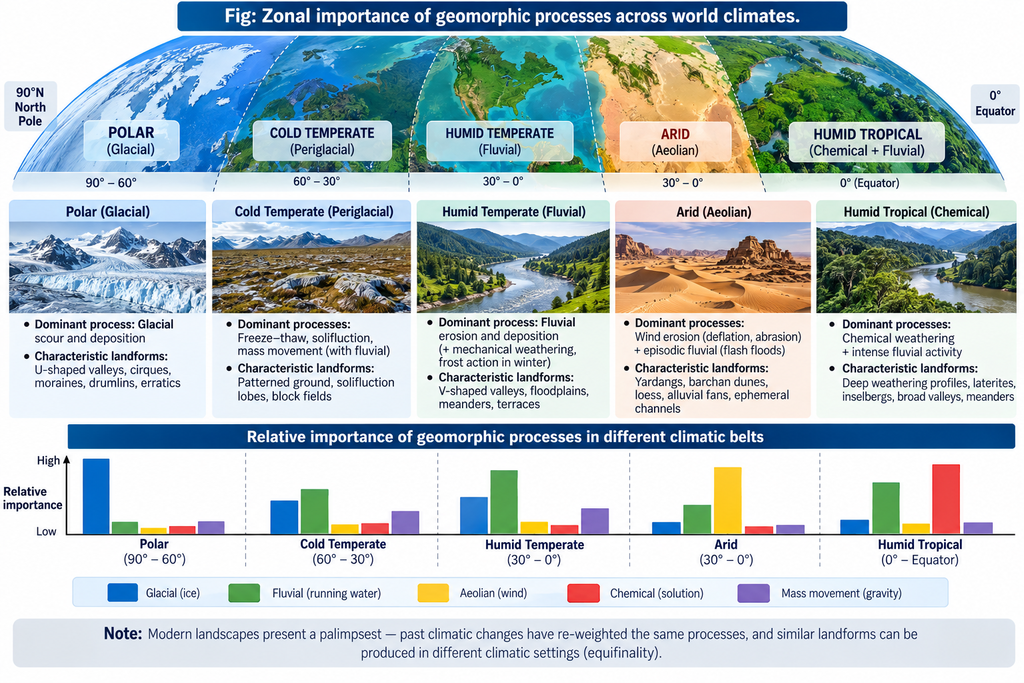
The statement captures the core proposition of what geomorphologists call the morphoclimatic school — that exogenetic processes (weathering, erosion, transport, deposition) are climate-conditional, and that their relative importance varies systematically across the world’s climate belts (Peltier, Büdel, Strakhov, Wilson; morphoclimatic regions of Tricart & Cailleux). The present is the key: a geomorphologist who knows only the processes but not the climate cannot predict which process dominates where, what landform ensemble will result, or how a change in climate will re-weight the geomorphic balance. The statement is therefore not merely true — it is axiomatic for zonal geomorphology, and it extends into interpretation of the past: because climates changed (Pleistocene glacial-interglacial oscillations), the past importance of processes differed — so reading present landscapes requires knowing both present and past climates.
1. The Theoretical Framework: Zonal vs Azonal Processes
- Zonal (climate-conditional) processes — weathering (chemical vs mechanical), fluvial erosion, aeolian action, glacial and periglacial processes, coastal storminess — are amped or damped by temperature, precipitation, humidity, and seasonality.
- Azonal processes — tectonic uplift/isostasy, volcanism, gravity-driven mass movement — operate in every belt, but even their surface expression (slope form, drainage) is modulated by the local climatic weathering/erosion regime.
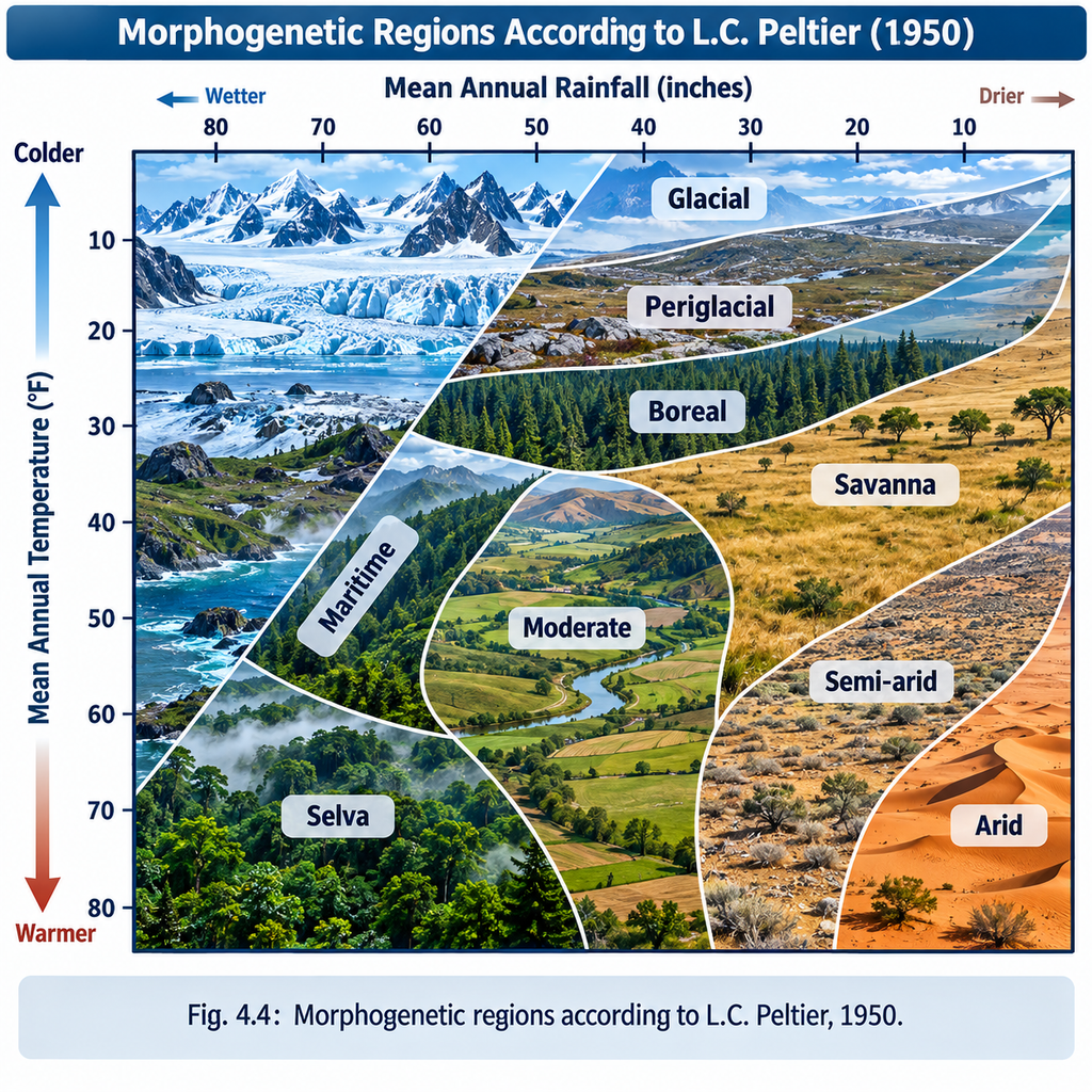
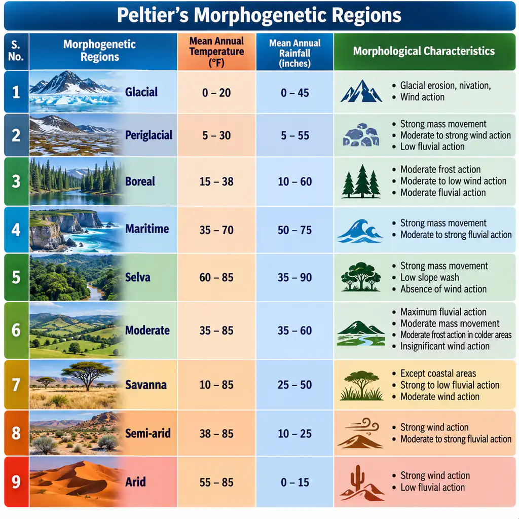
- Peltier’s (1950) process-field model: plots mean annual temperature vs precipitation; weathering regimes are delineated — strong mechanical weathering (cold & humid), moderate mechanical (cold-dry), moderate chemical (warm-moderate rain), strong chemical weathering (warm & very humid). The relative importance of frost wedging vs solution vs hydration varies entirely with the climate field.
- Büdel (1963) coined “morphoclimatic zones” — climatic forcing moulds a characteristic landform suite in each zone; Tricart & Cailleux mapped morphoclimatic regions at the global scale. Both rest on the statement’s logic.
2. How Climate Re-Weights Process Importance: A Global Gradient
| Climate belt | Dominant process | Depressed processes | Signature morphology |
|---|---|---|---|
| Equatorial/humid-tropical | strong chemical weathering (lateritisation, hydrolysis); intense fluvial incision, sapping | frost action, aeolian | deep regolith, etchplains, bombardts, corestones (Büdel), thick laterites (India’s laterite plateaus) |
| Tropical wet-dry / savanna | chemical + seasonal fluvial sheet/guiley erosion; duricrusting | glacial | pediments, inselbergs, ferricretes/calcretes |
| Subtropical arid/dry desert | mechanical weathering (insolation, salt/spalling), aeolian deflation & abrasion, sporadic flash-flood fluvial | chemical, glacial | yardangs, zeugen, desert pavements, barchan/seif dunes, hamadas, alluvial fans, playas |
| Temperate humid / mediterranean | balanced fluvial work, moderate chemical weathering, hillslope processes | glacial intensity low | graded streams, deep V-valleys, terraces, calcrete/caliche in mediterranean |
| Cold continental (boreal) | periglacial processes — frost heave, solifluction, gelifraction; seasonal river ice effects | chemical | patterned ground, ice-wedge polygons, pingos, asym-metric valleys, loess plains |
| Polar/glacial | glacial ice erosion & deposition; nivation | chemical, fluvial | U-troughs, cirques, fjords, moraines, outwash plains, erratics |
- Key point: the same physical laws operate everywhere — but their importance ranking flips with climate. Fluvial processes are primary in the monsoon tropics, intermittent in deserts, subordinate under ice. Appreciation of climate thus tells the geomorphologist which process to foreground in explaining a landscape.
3. Climate Also Sets Process RATES and MATERIAL FLOW
- Chemical weathering rate: doubles roughly with every ~10°C temperature rise; hence humid-tropical rates are an order of magnitude higher than boreal ones — controlling regolith thickness, slope stability, river loads.
- Fluvial efficacy: monsoon regimes (India) produce >80% of annual runoff in ~90–100 days — a flashy, high-energy fluvial imprint (deep incision, large sediment yields, braiding in the Ganga megafan), vs uniform temperate discharge which builds graded, stable channels.
- Aeolian material budget: deserts and semi-arid peripheries supply dust (global dust transport: ~2,000 Mt/yr); loess deposition in the mid-latitudes records late-glacial arid-and-windy climates.
- Glacial metabolism: temperature/precipitation of accumulation zones control mass balance → controls moraine building, erosion rates, glacier surges — the integral of climate over centuries.
4. The Past Dimension: Climate Change Re-weights Processes Over Time
- Pleistocene as the supreme test: glacial-interglacial (4 glacial / 4 interglacial episodes in many schemes) oscillation moved the morphoclimatic belts and re-weighted processes over the same ground — hence:
- Fossil periglacial features in mid-latitudes (ice-wedge casts of England/Poland) record a time when periglacial processes dominated there.
- Fossil dunes of the Thar/Rajasthan record a drier, aeolian-dominant past; laterite caps in Chotanagpur (Netarhat ~1,065 m) record a wetter tropical past.
- Older erosional surfaces in presently vigorous rivers (e.g., rejuvenated Himalayan course reading) record past states of stronger chemical weathering or planation.
- Consequence: present-day landscape is a hybrid — a palimpsest of landforms each engraved when its process was climate-weighted (relating directly to Q28–Q31 of this session). Understanding present morphogenesis therefore requires both the present climate and palaeoclimates.
5. Applications: Why This Appreciation Is Practical
- Landform interpretive archaeology: mature understanding of process importance under a given climate lets us assign relict suites to past climates (the reverse application of the axiom).
- Terrain evaluation & hazard: knowing process-climate linkages predicts erosion, landsliding, desertification, coastal recession under changing climate (rainfall-intensification → gully erosion in Chambal badlands; permafrost thaw → thermokarst where ground-ice exists).
- Soil & landuse planning: laterite vs calcrete vs frozen ground distributions are process maps of climate — used in agriculture, engineering, water-resource planning.
- Quaternary and Anthropocene test-bed: climate change (including human-forced) is re-weighting processes today — glacial retreat (Himalayan glaciers thinning up to ~0.87 m/yr at South Lhonak), rainfall intensification (landslide cascades), coastal energy changes (sea-level rise + storminess) — the statement’s logic applied live.
6. Conclusion
The statement is correct and foundational. World climates set the relative importance of geomorphic processes — from chemical weathering in the humid tropics to glacial scour in polar regions, aeolian deflation in deserts, periglacial processes in cold continental zones, and fluvial work across the warm-moist and monsoon belts. No balanced account of any landscape is possible without locating its climate; conversely, the modern reconstruction of palaeoclimates from landforms is precisely the reverse axiom at work. The appreciation demanded is threefold: the spatial map of climate that keys process importance today; the temporal map of climate change that re-weighted process importance in the past; and the forward map of climate change that is re-weighting processes now — making morphoclimatic reasoning as forward-looking as it is retrospective.