

“State the concept of erosion surfaces and highlight the factors responsible for their development.” (2014)
- An erosion surface (also termed a planation surface) is a land surface of low relief produced by the prolonged action of denudational agents — running water, wind, or a combination of processes — cutting across whatever underlying rock structure and lithology happen to be present, so that the surface’s flatness records the work of erosion rather than any pre-existing structural flatness in the rock itself.
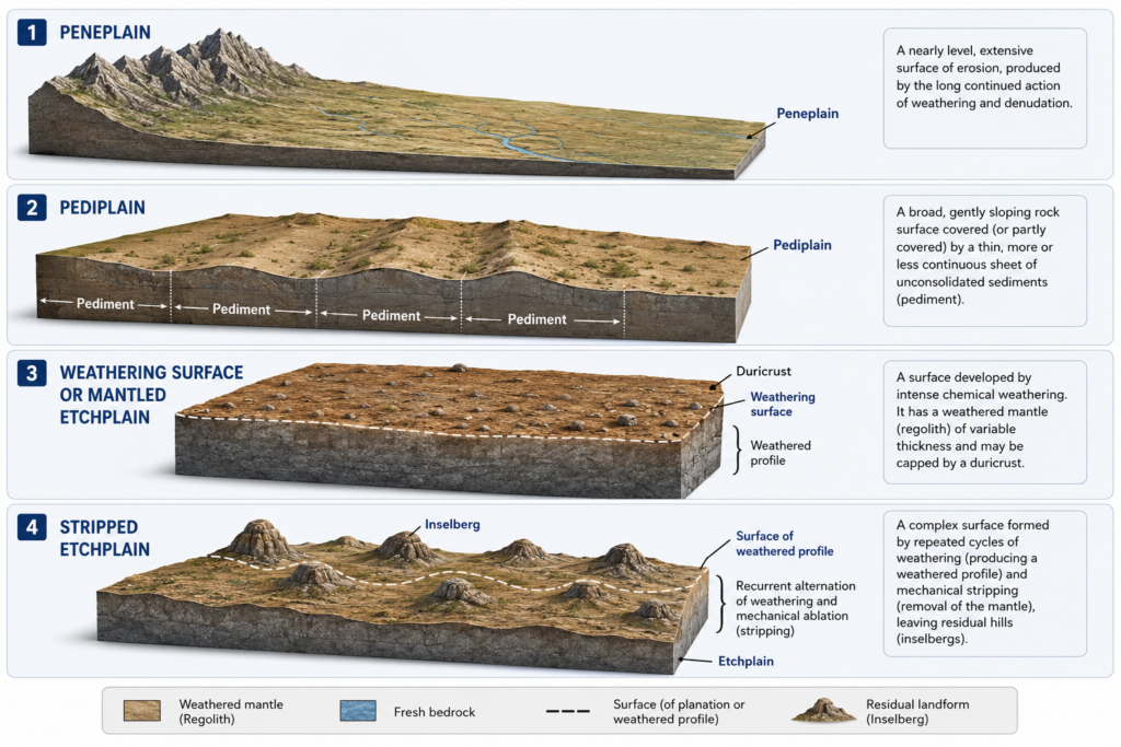
- W.M. Davis’s concept of the peneplain, the near-level end-form toward which his geographical cycle (1899) directs a humid-temperate landscape through its youth-maturity-old age sequence, remains the foundational reference point for the erosion-surface concept, even though later geomorphologists — L.C. King with the pediplain and Walther Penck with the Endrumpf — proposed alternative erosion-surface end-forms produced through different mechanisms.
- The thesis argued here: an erosion surface’s actual development depends on a specific, identifiable set of enabling conditions — sufficient geological time, a stable and unchanging base level, prolonged crustal stability, a susceptible or sufficiently varied rock structure, and an appropriate climatic-process regime — and it is precisely because these conditions are rarely all satisfied simultaneously and without interruption that genuinely complete, “textbook” erosion surfaces are the exception rather than the norm in most real landscapes.
The Concept: What an Erosion Surface Actually Represents
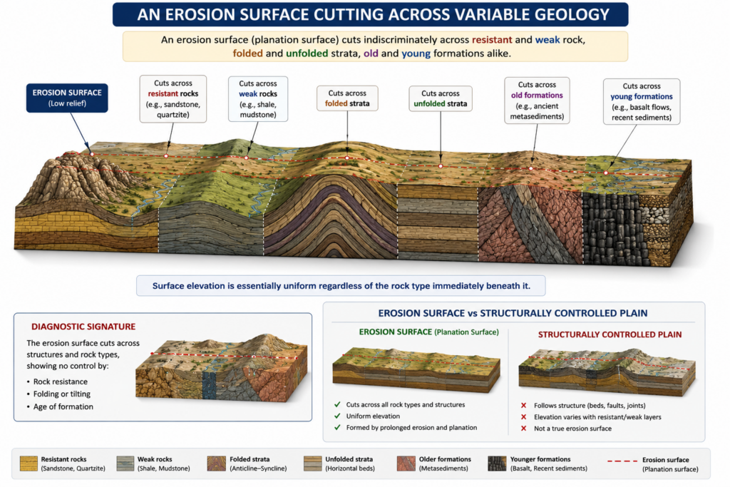
- The defining diagnostic feature of a genuine erosion surface is that it cuts across diverse bedrock types and geological structures alike — a plain whose flatness instead follows a single uniform, weak rock layer (a structural plain) is a fundamentally different phenomenon and not a true erosion surface in this sense.
- Erosion surfaces are typically identified today only as remnants, since subsequent uplift and renewed dissection have usually destroyed large parts of the original surface, leaving isolated flat-topped hills, bevelled ridge crests, or dissected plateau fragments as the only surviving evidence of a formerly much more extensive level surface.
- A frequently cited field indicator is the bevelled cuesta: where the flat top of a cuesta sits at approximately the same elevation as the flat tops of several other nearby, structurally unrelated features, this recurring, structure-independent elevation is treated as credible evidence that an older, now largely dissected erosion surface once extended across the entire area.
- The broader analytical project of identifying, dating, and interpreting these surfaces is termed denudation chronology, whose underlying goal, in the words of geomorphologist R.J. Small, is to identify, date, and interpret erosion surfaces developed during past cycles and sub-cycles of erosion using evidence from drainage development, river capture, relict surfaces, and past tectonic events.
Factor 1: Sufficient Geological Time
- The single most fundamental precondition for erosion surface development is an adequate span of geological time, since reducing an uplifted landmass to a genuinely low-relief surface through ordinary subaerial denudation is an inherently slow process requiring many millions of years of sustained, largely uninterrupted erosional work.
- Davis’s own model made this requirement explicit, envisaging the complete geographical cycle as needing an extremely long, largely uneventful period — a requirement Davis’s critics later flagged as geologically unrealistic, since plate tectonics has since demonstrated that the crust is essentially never stationary for the multi-million-year, uninterrupted spans a “complete” cycle would ideally need.
Factor 2: Crustal Stability and a Constant Base Level
- A surface can only be reduced toward a genuinely low-relief end-form if the land remains tectonically stable for a sufficiently long interval, since renewed uplift interrupts the reduction process, restarts vigorous vertical erosion (rejuvenation), and prevents the landscape from ever reaching the fully graded, low-relief state an erosion surface represents.
- Equally important is a stable, unchanging base level — normally sea level — since a river’s or a whole drainage system’s erosion is fundamentally graded toward this controlling lower limit, and any change in base level (through eustatic sea-level fluctuation, regional crustal warping, or local damming) shifts the target the erosional system is working toward, again interrupting surface development before it can be completed.
- This is precisely why interruptions caused by base-level change (termed an “accident” when caused by volcanic eruption or climatic shift, or “rejuvenation” specifically when caused by a fall in base level) are treated in classical geomorphology as the primary obstacle preventing any single erosion-surface-forming cycle from running fully to completion.
Factor 3: Rock Structure and Lithological Susceptibility
- The underlying rock’s structure and resistance characteristics directly govern both the rate and evenness with which an erosion surface can develop: a landscape built from relatively homogeneous, moderately resistant rock is reduced more evenly and completes a surface-forming cycle more efficiently than one built from sharply alternating hard and soft strata, which instead tends to develop differential relief (cuestas, hogbacks, structural benches) that resists smooth, uniform lowering.
- Where resistant rock does survive the general reduction of the surrounding landscape, it stands above the developing erosion surface as an isolated residual hill — termed a monadnock in the humid (Davisian) cycle, or an inselberg in the arid/semi-arid (King’s pediplanation) cycle — meaning even a genuinely well-developed erosion surface rarely achieves perfectly uniform flatness across its full extent.
- The specific process by which the surface is actually cut also depends on structural setting: slope decline toward a peneplain, parallel scarp retreat producing a pediplain, or the piedmont-staircase pattern of Penck’s Endrumpf, each of which leaves a somewhat different structural and morphological signature on the resulting surface.
Factor 4: Climate and the Dominant Erosional Process Regime
- The climatic regime under which denudation proceeds determines which erosional processes actually do the surface-forming work and, correspondingly, what form the resulting surface takes: humid-temperate conditions favour fluvial slope decline toward a peneplain, while arid and semi-arid conditions favour combined fluvial-aeolian-mass-wasting action and parallel scarp retreat toward a pediplain.
- Climatic change over the course of surface development is itself a major complicating factor rather than a fixed background condition: since a full cycle of erosion surface formation typically requires timescales long enough to span multiple climatic phases (including, in many mid-to-high-latitude regions, alternating glacial and interglacial conditions across the Pleistocene), the processes actively shaping a given surface may well change partway through its formation, producing a polygenetic rather than single-process surface.
- This climatic dimension is precisely why an erosion surface’s present appearance often reflects inherited, palimpsest-style overprinting: a surface substantially shaped under one climatic regime may subsequently be partially modified by a quite different process suite once the regional climate itself has shifted, meaning many real erosion surfaces do not cleanly record a single, uninterrupted formative episode.
- An erosion surface is fundamentally a record of sustained denudational work cutting indiscriminately across underlying geological variation, and its actual development depends on the simultaneous, sufficiently prolonged satisfaction of several distinct conditions: adequate time, crustal and base-level stability, a workably susceptible rock structure, and a consistent climatic-process regime.
- Because these conditions rarely all hold simultaneously without interruption over the immense timescales genuine surface reduction requires, most observed erosion surfaces are properly understood as partial, interrupted, or composite products rather than the clean, textbook end-forms the classical cyclic models (Davis’s peneplain, King’s pediplain) describe in their idealised form.
- This is exactly why denudation chronology remains a genuinely demanding interpretive exercise rather than a simple matter of spotting a flat surface: correctly reading a given erosion surface’s history requires disentangling how much of its present form reflects each of these several enabling and disrupting factors, rather than assuming it records one single, uncomplicated cycle of formation.