

“”Present-day landforms bear more complexity than simplicity”. Elucidate.” (2015)
- W.M. Davis’s original geographical cycle (1899) offered a deliberately simple, single-process, single-climate model of landscape evolution — uplift followed by an uninterrupted passage through youth, maturity, and old age toward one clean end-form, the peneplain — a model whose very elegance depended on stripping away exactly the complications real landscapes actually contain.
- The concept of palimpsest topography, drawn from the idea of a manuscript written, partially erased, and rewritten multiple times, captures the alternative, more accurate view: most present-day landscapes bear the superimposed imprint of several successive geomorphic episodes, each only partially erasing the evidence of the one before, so that a single landscape simultaneously carries traces of multiple ages, climates, and processes rather than the record of one clean, uninterrupted cycle.
- The thesis argued here: present-day landforms are overwhelmingly polygenetic and multi-temporal rather than the product of any single, simple, uninterrupted process — repeated tectonic interruption, climatic oscillation, and the co-existence of active and inherited (relict) landforms within the same landscape together make genuine geomorphic “simplicity” the rare exception rather than the observed norm, which is precisely why the statement’s claim holds up under scrutiny.
Why the “Simple” Model Was Always an Idealisation
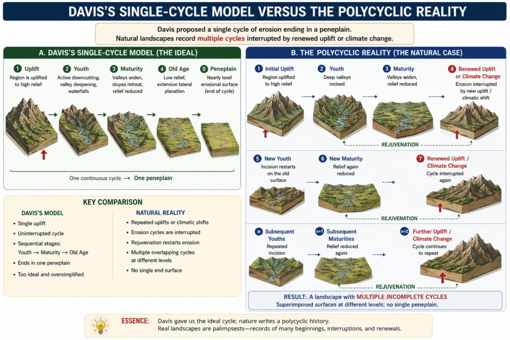
- Davis’s own model required an implausibly long period of uninterrupted crustal stability for a full cycle to reach completion — a condition modern plate tectonics has shown to be geologically unrealistic, since the crust is continuously, if variably, in motion rather than resting through the multi-million-year stillness the “simple” cycle presupposes.
- Even Davis himself anticipated this problem, acknowledging that where sustained stability is not available, the cycle is instead “interrupted,” and a fresh cycle begins before the previous one has run to completion — meaning the theoretical possibility of landscape complexity was, in effect, already built into the model’s own escape clause, even though the model’s popular application often glossed over it in favour of the cleaner three-stage narrative.
- Walther Penck’s critique sharpened this point further: he argued landforms are not simply time-dependent stages in a fixed sequence but rather direct “expressions of the phase and rate of upliftment in relation to the rate of degradation” — meaning the same landform can arise from entirely different tectonic-erosional combinations, which is itself a form of complexity Davis’s staged model could not easily accommodate.
Rejuvenation and Polycyclic Landscapes: Complexity Written Directly Into the Landscape
- Rejuvenation — the renewed vigour of a river’s erosive capacity following a fall in base level, whether from tectonic uplift or a drop in sea level during glacial periods — drives a river’s cycle abruptly back toward youthful, rapid vertical erosion even where the surrounding landscape remains at a more mature or advanced stage, producing landforms that are internally inconsistent with a single, simple stage classification.
- This process generates a specific and immediately recognisable family of complex landforms: valley-in-valley (multi-storeyed valley) topography, paired terraces, incised meanders, nick points and nick-point waterfalls, uplifted (dissected) peneplains, and deeply entrenched gorges and canyons cut within otherwise broad, flat older valleys — every one of these is, by definition, a landform that only makes sense as the superimposition of at least two distinct erosional episodes on the same site.
- Landscapes recording several such complete or incomplete cycles are termed polycyclic or multicyclic landforms, with the Chotanagpur Plateau region of India offering a well-documented example of a landscape whose surface preserves the evidence of multiple successive erosional episodes rather than a single, clean cyclical history.
- “Polycyclic landforms or multicyclic landforms” — a term whose very existence as a standard part of geomorphological vocabulary is itself evidence that the “single simple cycle” case is understood by geomorphologists to be the exception, not the rule, across most real landscapes.
Palimpsest Topography: Active and Relict Landforms Coexisting in the Same Landscape
- The palimpsest concept most directly elucidates the statement’s claim: present landscapes are typically a mosaic of landforms of genuinely different ages, with some surface features being actively shaped by current processes (a gravel bar in today’s active river channel, for instance) sitting immediately alongside other features that are relict — shaped potentially millions of years ago under a climatic regime or process no longer active in that location at all.
- The clearest global illustration is the survival of periglacial landforms (block fields, cryoplanation terraces, patterned ground) in mid-latitude uplands that are today under a temperate, non-periglacial climate — these features are a direct physical record of Pleistocene cold-stage conditions persisting, only partially modified, into a present-day landscape shaped by an entirely different climatic regime.
- S.A. Schumm and R.W. Lichty’s (1965) episodic erosion theory offers a further, more explicitly complexity-embracing framework: they distinguished cyclic time (the very long timescale over which large landforms evolve), graded time (the shorter timescale over which a river maintains a dynamic equilibrium profile), and steady time (the shortest timescale of moment-to-moment process fluctuation) operating simultaneously within the same landscape — a direct acknowledgement that a single landform can be simultaneously “evolving” at one timescale and “in equilibrium” at another, a form of complexity a single-stage model has no vocabulary to express.
- The methodological consequence is significant: purely statistical approaches to landform analysis — treating a landscape as a single population of measurable slope angles or drainage densities — are limited precisely because they fail to represent sequence in either time or space and struggle to interpret genuinely complex, palimpsest or polygenetic landscapes from aggregate statistical data alone, reinforcing that complexity is not merely a descriptive nuance but a genuine analytical challenge for the discipline.
A Contemporary Value Addition: Human Modification as a New Layer of Complexity
- Beyond the classical tectonic-and-climatic sources of landscape complexity, the accelerating pace of anthropogenic landscape modification — dam construction altering downstream sediment and channel dynamics, urbanisation altering runoff and slope stability, and large-scale land-use change altering erosion rates — is now adding a further, historically unprecedented layer of complexity on top of the inherited tectonic-climatic palimpsest, meaning present-day landscapes must increasingly be read as a superimposition of natural and human-induced episodes rather than natural processes alone.
- Present-day landforms bear more complexity than simplicity precisely because the conditions a truly “simple” single-cycle landscape would require — one uninterrupted period of tectonic stability, one constant climatic regime, one continuous process acting without interruption — essentially never persist over the geological timescales landform evolution actually requires.
- Rejuvenation-driven polycyclic landforms and palimpsest-style coexistence of active and relict features are not exceptions to be explained away but the expected, default condition of most real landscapes, which is exactly why concepts like multicyclic topography and episodic time-scaling had to be developed once geomorphologists looked closely enough at actual landscapes rather than idealised models.
- Recognising this complexity has direct practical consequence: correctly reading a landscape’s full polygenetic history — rather than assuming a single simple explanatory cycle — remains essential for applied tasks from hazard assessment to resource exploration, since a landform’s present form frequently encodes a multi-episode history that a simple, single-process reading would seriously misinterpret.