

“”Geological structure has a dominant control on landforms and is reflected on them.” Discuss.” (2016)
- W.M. Davis placed structure first among his celebrated trio of controls on landform development — structure, process, and stage — defining it broadly to include not just rock type but the “manner of disposition of underlying rocks, level of hardness, porosity, folds and faults,” a definition wide enough to anchor this entire discussion.
- Geological structure operates as a control on landforms in two related but distinct ways: through lithology (differences in rock hardness, permeability, and resistance to weathering) and through tectonic architecture (folds, faults, joints, and the dip and strike of strata) — and both leave a legible imprint on the resulting landscape, from continental-scale mountain trends down to the shape of a single ridge.
- The thesis argued here: while climate and geomorphic process ultimately do the work of sculpting a landscape, it is structure that supplies the raw template — the pattern of resistant and weak rock, the orientation of folds and faults — that process then exploits, meaning the same climatic regime acting on different structures produces recognisably different landforms, which is precisely why structure is rightly treated as a dominant, not merely incidental, control.
Lithological Control: Differential Erosion of Hard and Soft Rock
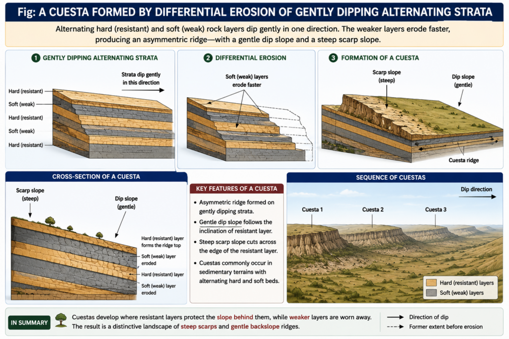
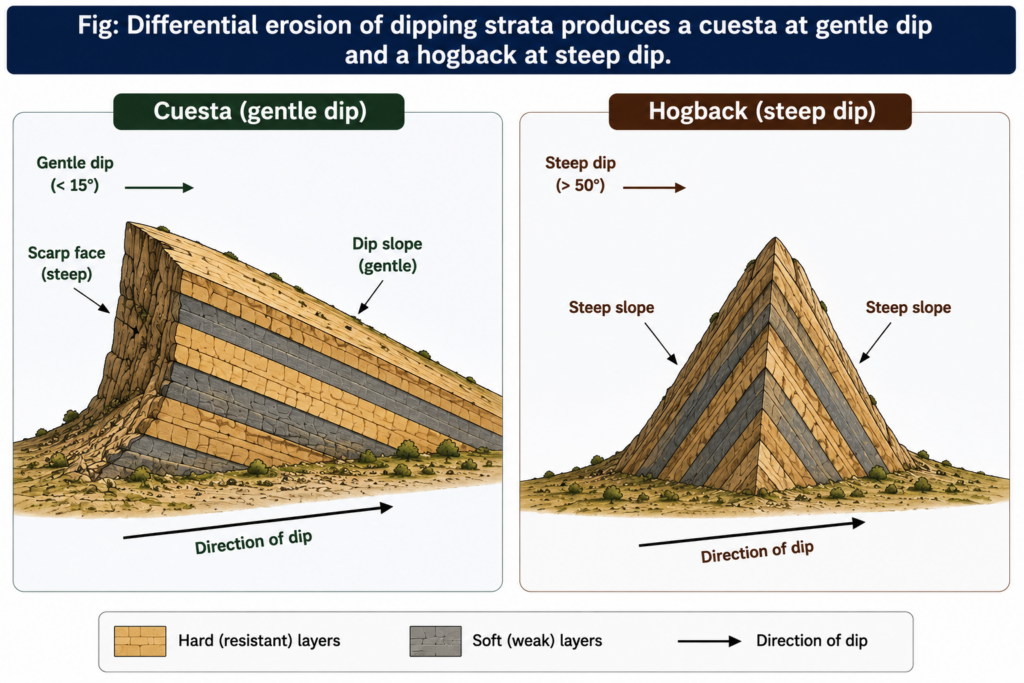
- Where rock resistance varies but structural dip is gentle (under roughly 15 degrees), differential erosion carves the landscape into a stepped sequence of cuestas — asymmetric ridges with a long, gentle dip slope paralleling the resistant bed and a short, steep scarp face cut across it — a landform whose very asymmetry is a direct, readable record of the underlying rock’s dip direction.
- Where dip steepens beyond roughly 50 degrees, the same differential-erosion process instead produces a hogback — a narrow, sharp-crested ridge with nearly symmetric steep slopes on both flanks, since at such steep dips there is no longer a meaningfully “gentle” side to the ridge.
- Wind erosion in arid regions demonstrates the same lithological principle on a smaller scale: the differing erosional effect of wind-driven abrasion on soft versus resistant rock bands produces streamlined ridges and grooves that faithfully trace the underlying rock’s resistance pattern, independent of any tectonic dip at all.
- Bevelled cuesta tops — flat-topped remnants sitting at a consistent elevation across several separate cuestas in an area — are themselves used by denudation chronologists as evidence of a former, now-dissected erosion surface, showing how a purely lithological landform can also encode information about the region’s longer erosional history.
Structural (Tectonic) Control: Folds, Faults, and Drainage Patterns
- Folded strata directly control both relief and drainage: in a classic folded-mountain setting, master streams establish themselves as consequent streams flowing down the initial fold-controlled slope, after which tributaries develop in the weaker, more erodible rock exposed along the fold axes, producing a trellis drainage pattern — primary tributaries flowing parallel to the fold trend, joined at right angles by short secondary tributaries.
- “Trellis drainage is characteristic of folded mountains” — exemplified by the Appalachian Mountains of North America and the Seine and its tributaries in the Paris Basin, both landscapes where the drainage net itself is a direct map of the underlying fold structure.
- Faulting produces its own distinctive structural landforms: a fault scarp — a steep slope directly created by vertical displacement along a fault plane — remains a genuinely tectonic slope distinguishable from an erosionally produced scarp, while paired, parallel normal faults bounding a down-dropped block produce a graben (rift valley), with the flanking upthrown blocks forming horsts.
- The East African Rift Valley, extending from the Red Sea through Ethiopia, Kenya, and Tanzania, is a textbook large-scale example of this fault-controlled architecture, its associated volcanic peaks (Kilimanjaro, Mount Kenya) themselves exploiting the crustal weakness the rift faulting created.
- A parallel drainage pattern, in which streams run in closely spaced, near-identical courses down a uniformly steep slope, is itself often diagnostic of a major fault cutting across steeply folded bedrock — again illustrating how a drainage pattern, ordinarily thought of as a purely fluvial-process outcome, is in fact frequently structure-determined at its root; the rivers of the Lesser Himalaya show this pattern clearly.
- Domal and anticlinal structures leave their own signature even where topography alone is ambiguous: subtle tonal differences in vegetation and drainage-anomaly patterns visible on aerial photography can reveal a buried anticline or dome, a relationship economically significant enough that petroleum geologists routinely use drainage and tonal analysis to locate the structural traps (folded permeable strata sealed beneath impermeable beds) in which oil and gas accumulate.
Structural Control at the Regional and Continental Scale: Indian Examples
- The Vindhyan-Aravalli boundary, marked by the Great Boundary Fault running for roughly 800 kilometres, produces a continuous line of distinct fault scarps separating the two geological provinces — a single structural feature whose surface expression remains traceable across the entire length of the fault.
- The Bhander Plateau’s northeastern margin displays a well-developed cuesta-and-hogback landform, its escarpment face capped by resistant Upper Bhander/Maihar sandstone overlying weaker strata — a direct, present-day illustration of the same differential-erosion mechanism described above, expressed at genuine regional scale.
- More broadly, the entire trend of India’s major fold-mountain and plateau margins — from the Himalayan arc’s east-west trending ranges (reflecting the orientation of continental collision) to the sharply defined scarps bounding the Peninsular plateau — testifies to structure operating as a first-order control on landform pattern at the scale of the subcontinent itself, with climate and process subsequently modifying, but not overriding, this structural template.
- Structure’s dominance as a control on landforms lies precisely in the fact that it is the most enduring of Davis’s three variables: process (weathering, fluvial action, wind) and stage (the passage of time) both operate on whatever structural template rock type, folding, and faulting have already laid down, meaning structure supplies the initial conditions that everything else subsequently modifies rather than erases.
- The pervasiveness of structurally diagnostic landforms — cuestas and hogbacks revealing dip direction, trellis and parallel drainage revealing fold and fault trends, fault scarps directly marking displacement — demonstrates that structure is not merely one input among equals but is genuinely read off the landscape by any trained geomorphologist, which is the concrete sense in which structure is “reflected on” landforms rather than simply influencing them from behind the scenes.
- This is also why structural analysis retains direct practical value well beyond academic geomorphology: petroleum geologists locating anticlinal traps, engineers siting dams and roads around fault zones, and hydrogeologists tracing groundwater along joint and fracture systems all depend on reading structural control back out of surface landforms, confirming that the relationship the statement describes runs in both directions — structure shapes landforms, and landforms in turn reveal structure.