

“Describe the “Basket of Eggs topography”.” (2016)
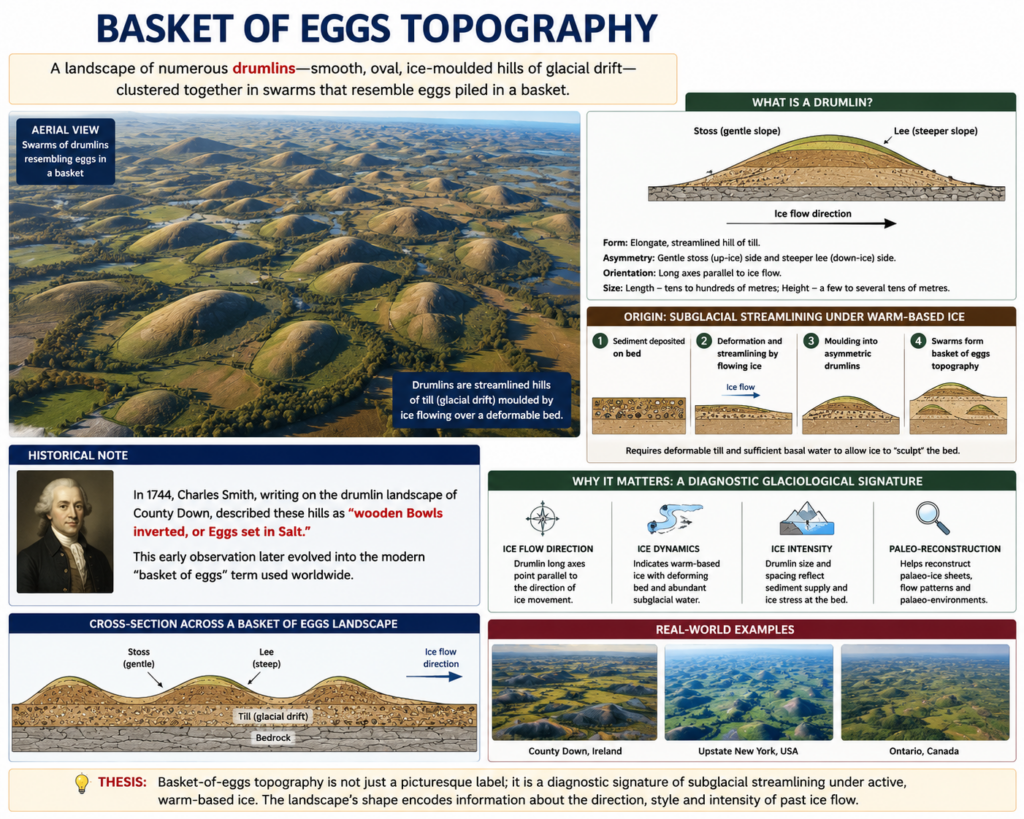
- “Basket of eggs” topography is the descriptive term applied to a landscape dominated by numerous drumlins — smooth, oval, ice-moulded hills of glacial drift arranged in tightly-packed clusters or “swarms,” whose rounded, egg-like silhouettes when seen scattered together across a lowland resemble eggs piled loosely in a basket.
- The term traces back to an even older, pre-scientific description: Charles Smith, writing on the drumlin landscape of County Down in 1744, compared these hills to “wooden Bowls inverted, or Eggs set in Salt” — a phrase later crystallised into the modern “basket of eggs” idiom used throughout glacial geomorphology.
- The thesis argued here: basket-of-eggs topography is best understood not merely as a picturesque label but as a genuine diagnostic signature of a specific glaciological process — subglacial streamlining under active, warm-based ice — meaning the landscape’s very shape encodes detailed information about the direction, style, and intensity of past ice flow.
The Drumlin: Anatomy of the Individual Landform
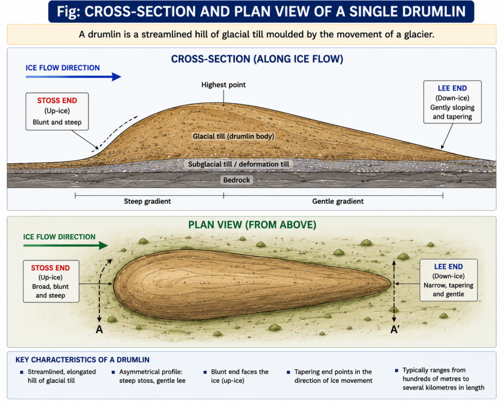
- A drumlin is an elongated hill composed largely of glacial till (unsorted glacial drift), formed beneath an active glacier or ice sheet and streamlined in the direction of ice movement — typically reaching up to about 1.5 kilometres in length and up to roughly 60 metres in height, though most are considerably smaller.
- Its distinctive asymmetric profile is diagnostic of flow direction: a blunt, steeper “stoss” end faces the direction the ice was advancing from, while a gently tapering “lee” end trails away in the direction the ice was flowing toward — allowing geomorphologists to read the palaeo-ice-flow direction directly off the landform’s shape without any other evidence.
- Individual drumlins are typically composed of compact boulder clay or till, moulded and shaped by the shearing and pressure of overriding ice, though some drumlins have a core of pre-existing bedrock or older sediment around which the till has been streamlined — a distinction geomorphologists term rock-cored versus till-only drumlins.
From Individual Landform to Landscape: How Basket-of-Eggs Topography Forms
- The “basket of eggs” character emerges only at the landscape scale, once dozens or hundreds of individual drumlins are considered together as a drumlin field or swarm — a single isolated drumlin, however well-formed, does not itself constitute this topography.
- Drumlin swarms form beneath warm-based, actively flowing ice in the zone where a glacier or ice sheet is depositing and reworking till in bulk rather than simply eroding bedrock — the precise mechanism remains debated among glaciologists, but the leading explanations converge on subglacial deformation and streamlining of a saturated till bed under the combined stress of ice flow and high subglacial water pressure.
- “Drumlins are swarms of oval, elongated hummocks composed of boulder clay or glacial till, formed by the movement of ice” — a description that captures the essential point that a drumlin field is a single depositional-cum-erosional event across an entire subglacial bed, not an accumulation of separately formed hills.
- Within a swarm, individual drumlins are consistently aligned parallel to one another and to the direction of regional ice flow, giving the swarm a distinctive grain or texture when viewed on a map or from the air — this parallel alignment across dozens of hills simultaneously is precisely what produces the “basket of eggs” visual effect, distinguishing it from a random scatter of isolated hills.
- The spacing and density of drumlins within a field also carries information: closely packed, high-density swarms are generally associated with zones of especially vigorous or fast-flowing ice (sometimes linked to former ice streams), while more scattered, lower-density fields suggest slower or less concentrated ice flow.
Global Distribution and the Classic Irish Case
- Drumlin fields, and the basket-of-eggs topography they produce, are characteristic of regions that experienced extensive Pleistocene continental glaciation and are especially well developed in Canada, Ireland, Sweden, and Finland, alongside notable fields in northern England, Scotland, and the northern United States.
- Ireland hosts one of the densest and most celebrated drumlin belts in the world, forming a broad swathe across the northern midlands through counties such as Cavan and Monaghan, where the closely packed, rounded hills dominate the rural landscape so thoroughly that the terrain is popularly described as an archetypal “basket of eggs.”
- A particularly striking variant occurs at Clew Bay on Ireland’s west coast, where a drumlin field has been partially drowned by postglacial sea-level rise, leaving the tops of individual drumlins standing above the water as a scatter of small, rounded islands — a “drowned drumlin” landscape that reproduces the same basket-of-eggs pattern in an offshore, insular form rather than on dry land.
- Beyond their scenic and geomorphological interest, drumlin fields carry practical significance for groundwater and land-use planning, since the compact, low-permeability till composing them strongly influences local drainage patterns, soil development, and the routing of subsurface water across formerly glaciated terrain.
- Basket-of-eggs topography is, at its core, a legible record of a specific glaciological episode: hundreds of individually streamlined till hills, uniformly aligned and densely packed, testify to warm-based ice actively deforming a saturated subglacial bed across the entire area of the swarm.
- Because each drumlin’s asymmetric stoss-and-lee profile independently confirms ice-flow direction, a well-developed drumlin field allows geomorphologists to reconstruct the pattern and even relative timing of ice movement across an entire formerly glaciated region with a level of confidence few other glacial landforms can match.
- The continuing debate over the precise subglacial mechanism producing drumlin swarms — deformation, erosion, or some combination of both — means this deceptively simple, picturesquely named landscape remains an active area of glaciological research rather than a fully settled question.