

“”Climate, slope gradient and rock structure influence the avulsion of channels.” Explain.” (2017)
- Channel avulsion — the sudden, often catastrophic abandonment of an existing river channel in favour of a new course across the floodplain — is fundamentally distinct from the gradual, progressive channel-shifting of ordinary lateral bank erosion, and Nanson and Knighton’s (1996) classification of avulsion into first-, second-, and third-order events remains the framework of choice for analysing how different controls trigger this abrupt reorganisation of a river’s course.
- The statement’s three named controls — climate, slope gradient, and rock structure — operate through genuinely distinct mechanisms rather than a single shared pathway: climate governs the sediment and discharge regime that drives channel-bed aggradation, slope gradient determines the threshold at which a new course becomes hydraulically preferable to the old one, and rock structure (lithology, bedrock resistance, and tectonic setting) constrains where and how readily an avulsing channel can actually cut its new path.
- The thesis argued here: avulsion is best understood not as a single-cause event but as the product of a progressive loss of channel efficiency — most commonly through bed aggradation — that climate, slope, and structure each contribute to differently, and it is precisely this multi-causal character that explains why avulsion-prone reaches recur in predictable settings worldwide, from braided Himalayan foothill rivers to the deltas of major world rivers.
The Core Mechanism: Superelevation and Loss of Channel Efficiency
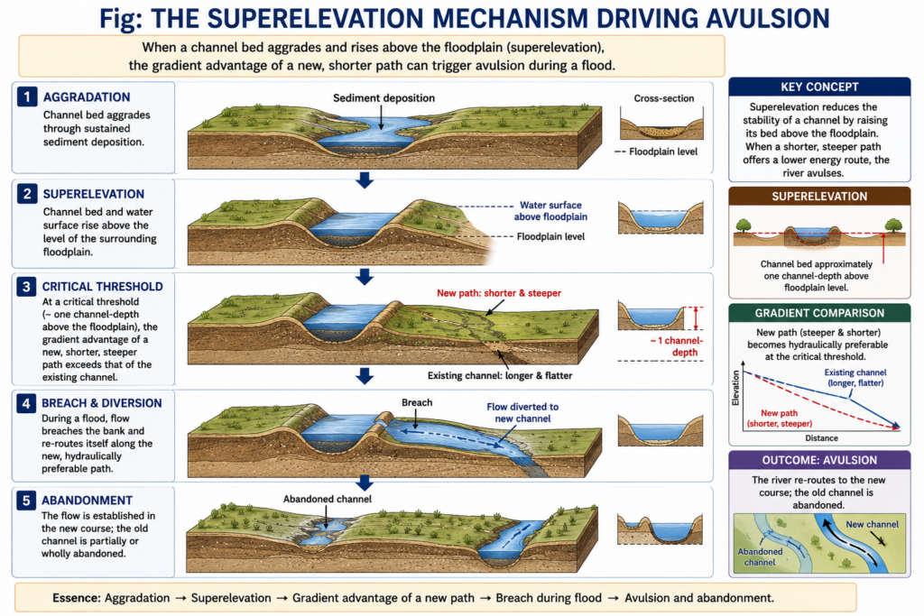
- The classical trigger for avulsion is superelevation: as a channel’s bed aggrades — through sustained sediment deposition exceeding the rate of removal — the channel bed and its bounding levees rise progressively above the surrounding floodplain, until the channel is, in effect, perched above the land it flows through.
- Avulsion becomes hydraulically likely once the channel has aggraded to roughly one channel-depth above the floodplain surface, because at this point a new, more direct path across the lower-lying floodplain offers a steeper, shorter, and therefore hydraulically more efficient route than continuing along the existing, superelevated course.
- Not every avulsion follows this aggradational pathway: erosional avulsion occurs where a new channel is cut headward (working upstream from a lower point) rather than by simple overbank breaching — one well-documented case is the 2006 Suncook River avulsion in New Hampshire, where a channel eroded backward at a remarkable 25–50 metres per hour after floodwater, backed up behind a mill dam, found and rapidly enlarged a new path.
- Avulsions are further classified by completeness: a full avulsion entirely abandons the original channel in favour of the new course, whereas a partial avulsion only diverts a portion of the flow, leaving both the old and new channels active simultaneously — a distinction that matters directly for flood-hazard assessment, since a partial avulsion can persist as a chronic, recurring flood risk along both channels rather than resolving into a single new stable course.
Climate as a Control: Governing the Sediment and Discharge Regime
- Climate controls avulsion primarily by setting the sediment supply and discharge regime that determines how quickly a channel bed aggrades: monsoonal and highly seasonal climates, which deliver the bulk of a river’s annual sediment load in a short, intense wet season, are especially prone to rapid channel-bed aggradation and consequent avulsion, since sediment accumulates faster than the channel can adjust its capacity.
- High-magnitude flood events, themselves a climatic phenomenon, are frequently the immediate proximate trigger for avulsion even where slow aggradation has been building the underlying superelevation for years or decades — the flood simply supplies the discharge needed to breach a bank once the channel has already been primed by climatically-driven sediment accumulation.
- Climatically-driven changes in vegetation cover further compound the effect: a drier climatic phase reducing floodplain vegetation density lowers bank cohesion and flow resistance, making an avulsive breach easier to initiate and sustain once it begins.
- Longer-term climatic shifts — glacial-interglacial transitions, or the monsoon’s own strengthening and weakening over geological time — have been linked to major historical avulsion episodes in large alluvial rivers, since a shift in the discharge-sediment balance a river channel is adjusted to can push an already-aggrading system past its avulsion threshold.
Slope Gradient as a Control: The Threshold for a Hydraulically Preferable Path
- Slope gradient operates as the geometric precondition that makes avulsion hydraulically attractive in the first place: on a low-gradient alluvial plain or delta, even a small amount of superelevation can make a new, more direct path across the floodplain measurably steeper — and therefore faster and more efficient — than the long, superelevated existing channel, explaining why avulsion is characteristically a lowland, low-gradient phenomenon rather than one common on steep, confined mountain reaches.
- A useful quantitative threshold for the related but smaller-scale process of meander cutoff — itself sometimes classed as a minor form of avulsion — is that a new, shorter path becomes preferred once the ratio of the existing channel-slope to the new cutoff-slope falls below roughly one-fifth, illustrating how directly a comparative-slope-advantage calculation governs whether flow abandons its existing course.
- On fan and delta surfaces, where gradient decreases systematically outward from the fan apex or delta head, avulsion frequency is characteristically highest near the point of steepest gradient change, since this is where a new path’s slope advantage over the existing aggraded channel is greatest — the classic explanation for repeated lobe-switching on deltas such as the Mississippi’s bird’s-foot delta, where the active distributary periodically avulses to a shorter, steeper path to the sea.
- Where gradient is instead relatively uniform and low across a wide floodplain, avulsion style tends toward gradual, diffuse channel splitting (anastomosis) rather than a single abrupt jump, since no single new path holds a decisive gradient advantage over the others.
Rock Structure as a Control: Constraining Where Avulsion Can Occur
- Rock structure — meaning the underlying lithology, bedrock resistance, and tectonic configuration of the valley or basin the river occupies — determines the physical latitude a river has to actually execute an avulsion, independent of the climatic and gradient conditions that make one hydraulically favourable.
- On unconsolidated alluvial and deltaic sediment, where bank material offers little resistance to erosion, an avulsive breach can widen and stabilise into a full new channel rapidly, which is precisely why the world’s classic avulsion-prone rivers — the Kosi, the Yellow River (Huang He), and the Mississippi’s delta distributaries — all flow across thick, unconsolidated alluvial or deltaic fill rather than bedrock-confined valleys.
- Conversely, where a river is structurally confined by resistant bedrock — a gorge, a fault-bounded valley margin, or a resistant rock sill crossing the floodplain — avulsion is effectively suppressed regardless of how superelevated the channel bed becomes upstream, because the valley walls physically prevent the flow from establishing an alternative course; avulsion in such settings, when it does occur, is concentrated at the points where the valley widens out of bedrock confinement.
- Active tectonics interacts with rock structure to both promote and redirect avulsion: localised subsidence along a fault zone or basin margin lowers the floodplain surface relative to the channel, effectively amplifying superelevation and increasing avulsion likelihood in that zone, while active uplift or fault-related tilting of the floodplain can bias the direction an avulsing channel takes, since flow will preferentially move toward the topographically lower, subsiding side.
- A further human-structural analogue is worth noting: an anthropogenically engineered avulsion occurred on the Cheslatta River in British Columbia, where the sudden release of water from a dam spillway cut an entirely new channel — demonstrating that the same superelevation-and-slope-advantage logic governing natural avulsion applies equally when the structural boundary conditions are altered by engineering rather than geology.
The Kosi River, India: A Composite Illustration
- The Kosi River in Bihar is the Indian subcontinent’s most cited avulsion case and illustrates all three controls acting together: heavy monsoonal sediment delivery from its rapidly eroding Himalayan headwaters (the climatic control) drives exceptional bed aggradation on the low-gradient north Bihar plain (the slope control), across thick, unconsolidated alluvial fan sediment offering minimal resistance to channel migration (the structural control).
- “The combination of high sediment yield, a low-gradient depositional fan, and unconsolidated alluvium makes the Kosi one of the most avulsion-prone rivers in the world” — a description capturing exactly how climate, slope, and structure jointly explain the river’s long historical record of course changes, culminating in the catastrophic 2008 eastward avulsion that displaced the channel by several kilometres and caused a major flood disaster.
- Over the historical period, the Kosi has migrated roughly 120 kilometres westward across its fan through repeated avulsion episodes, providing a real-world demonstration of exactly the mechanism this answer has described: progressive superelevation on a low-gradient, unconsolidated alluvial fan, punctuated by monsoon-triggered avulsive breaches.
- Avulsion is most productively understood as the outcome of three distinct but interacting controls rather than any single cause: climate supplies the sediment and discharge regime driving bed aggradation, slope gradient determines the threshold at which an alternative course becomes hydraulically preferable, and rock structure sets the physical limits within which an avulsive breach can actually develop into a stable new channel.
- This composite explanation accounts directly for the global distribution of avulsion-prone rivers — concentrated on low-gradient, unconsolidated alluvial fans and deltas under monsoonal or highly seasonal climates, from the Kosi to the Yellow River to the Mississippi delta — while explaining why bedrock-confined, tectonically stable reaches rarely avulse regardless of their climatic setting.
- Because avulsion concentrates catastrophic flood risk and reshapes settlement and agricultural patterns with little warning, understanding these three controls together, rather than any one in isolation, remains directly relevant to floodplain hazard management in avulsion-prone river basins such as the Kosi.