“”Geomorphological changes are largely responsible for environmental hazards in the Himalayan region.” Comment with relevant examples.” (2018)
- The Himalaya is the world’s youngest and most tectonically active fold-mountain system, still rising through the ongoing India-Eurasia continental collision, and it is precisely this continuing structural youth — steep relief, weak and highly fractured young sedimentary and metamorphic rock, high seismicity, and rapid denudation — that makes geomorphological change (rather than climate alone) the single most decisive control on the region’s environmental hazards.
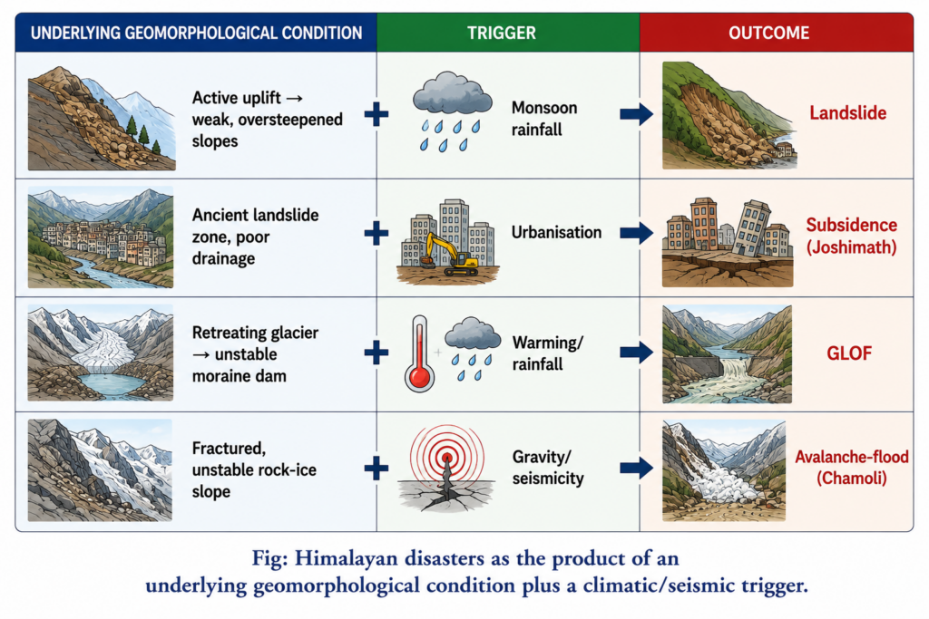
- Geomorphologists studying the Himalayan region have long argued that its hazard profile cannot be understood through climatology or hydrology alone, because nearly every major disaster type in the Himalaya — landslides, flash floods, glacial lake outburst floods, and increasingly land subsidence — originates from an underlying change in slope stability, channel geometry, or ground-surface integrity, with rainfall or seismicity typically acting only as the immediate trigger rather than the root cause.
- The thesis argued here: while climatic extremes and seismic events are the proximate triggers most often reported, it is the Himalaya’s continuously evolving geomorphology — active uplift maintaining oversteepened slopes, weak young lithology prone to failure, and increasingly human-modified terrain — that determines whether a given rainfall or earthquake event actually escalates into a disaster, making geomorphological change the underlying, largely responsible factor the statement identifies.
Active Tectonics as the Root Geomorphological Driver
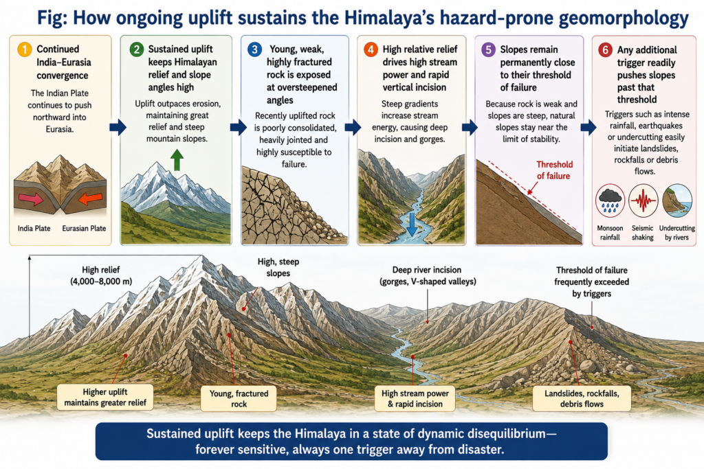
- The Himalaya’s active uplift is not a completed, historical event but a continuing process — the Indian plate continues converging with Eurasia at a few centimetres per year, measured directly today by GPS geodesy, meaning the region’s relief and slope steepness are being continuously regenerated rather than merely inherited from the past.
- This sustained tectonic activity keeps Himalayan rock — much of it young, weakly consolidated, and intensely folded, faulted, and fractured by the very collision that raised it — perpetually close to its threshold of slope failure, so that a rainfall or seismic trigger that a geologically stable, well-consolidated terrain could absorb without incident is often sufficient to initiate landslides or debris flows in the Himalaya.
- Seismicity directly compounds this instability: because the Himalaya lies within a zone of continuing continental collision, it experiences frequent earthquakes that both directly trigger landslides and, over repeated events, progressively weaken slope material through cumulative fracturing — the 2015 Nepal (Gorkha) earthquake and the 2011 Sikkim earthquake both triggered widespread landsliding across already geomorphologically fragile terrain, illustrating how seismic shaking converts latent slope instability into an actual mass-movement hazard.
Landslides and Slope Failure
- Landslides remain the most pervasive and recurrent geomorphological hazard across the Himalayan arc, driven by the combination of steep slopes, weak lithology, and intense monsoon rainfall that saturates and destabilises regolith on already oversteepened terrain.
- The 2013 Kedarnath disaster in Uttarakhand illustrates how geomorphological change compounds with extreme rainfall: cloudburst-driven flooding combined with the failure of a moraine-dammed glacial lake and extensive slope failure across the steep, structurally weak Mandakini valley, together producing a disaster whose scale far exceeded what the rainfall alone would have caused on more stable terrain.
- The 2021 Chamoli disaster, triggered by a massive rock-and-ice avalanche from a steep, geomorphologically unstable slope of Ronti Peak, generated a devastating flash flood down the Rishiganga and Dhauliganga valleys — a disaster originating not from rainfall at all but from the direct geomorphological failure of an oversteepened, glacially-undercut rock-ice slope, underscoring that slope instability itself, independent of any single climatic trigger, is a standing hazard across the region.
- Human-induced geomorphological change increasingly compounds these natural predispositions: unplanned road-cutting, tunnel excavation for hydropower projects, and deforestation for construction all further destabilise already marginal slopes, converting a latent natural hazard into a substantially amplified one.
Land Subsidence: The Joshimath Case as a Geomorphological Warning
- The Joshimath land subsidence crisis (acute phase 2022–2023) is among the clearest recent illustrations of the statement’s argument: the town itself sits, as established by the government’s own Mishra Commission as far back as 1976, on an ancient landslide zone — meaning the geomorphological instability was structurally inherited long before any recent trigger, not newly created by it.
- Multiple studies using satellite-based InSAR (interferometric synthetic aperture radar) deformation monitoring recorded subsidence rates in parts of the town reaching roughly 5 to 13 millimetres per year through 2022–2023, directly linked to a combination of the site’s inherent instability and compounding human interventions: unplanned urbanisation, inadequate drainage allowing water infiltration into already loose slope material, road cutting, hydropower tunnel excavation, and progressive deforestation.
- “Joshimath town rests upon an ancient landslide zone and is inherently geologically unstable” — the Mishra Commission’s 1976 finding, whose continued relevance nearly five decades later is itself evidence of how slowly Himalayan geomorphological hazards can telegraph their eventual escalation.
- Joshimath demonstrates a broader pattern across the Himalayan arc: many hazard “events” are not sudden, unforeseeable natural disasters but the eventual, often decades-delayed culmination of a known, pre-existing geomorphological instability whose risk was identified long before the crisis became acute — reinforcing that it is the underlying, continuously evolving geomorphology, not merely the final trigger, that is largely responsible.
Glacial and Fluvial Hazards
- Glacial Lake Outburst Floods (GLOFs) are a further direct expression of Himalayan geomorphological change: rapid glacial retreat under a warming climate leaves behind unstable, often moraine-dammed proglacial lakes whose weak, poorly-consolidated debris dams are prone to sudden breach, releasing catastrophic downstream flood surges — a hazard entirely rooted in the geomorphological transformation of the glacial landscape itself rather than in rainfall.
- River channel instability compounds flood hazard further downstream: the Himalaya’s high sediment yield, driven by its combination of steep relief and weak rock, produces rapidly aggrading river channels prone to sudden avulsion and bank erosion, meaning flood risk in the Himalayan foothills and adjoining plains is shaped as much by ongoing channel-bed and bank geomorphological change as by the discharge event itself.
- Taken together, these fluvial and glacial hazards share the same underlying logic as the region’s landslide and subsidence hazards: a climatic or seismic trigger (a cloudburst, a warming-driven glacial retreat, an earthquake) converts an already geomorphologically primed landscape into an actual disaster, rather than creating the hazard from an otherwise stable baseline.
- The recurring pattern across Kedarnath, Chamoli, Joshimath, and the region’s broader landslide and GLOF record is the same: a climatic or seismic event supplies the immediate trigger, but it is the underlying geomorphological condition — active uplift sustaining oversteepened, weak, fractured slopes, glacially unstable terrain, and increasingly human-modified ground — that determines whether that trigger produces a disaster.
- This distinction has direct policy significance: hazard mitigation focused only on improving climate forecasting or seismic early-warning addresses the trigger, but genuinely reducing Himalayan disaster risk requires geomorphological hazard mapping — identifying ancient landslide zones, unstable moraine-dammed lakes, and oversteepened slopes — of the kind the Mishra Commission attempted for Joshimath decades before the crisis became visible.
- As hydropower development, road construction, and settlement expansion continue to intensify human modification of Himalayan slopes even as climate change accelerates glacial retreat and rainfall extremes, the statement’s core claim is likely to become more, not less, true: geomorphological change, both natural and increasingly human-accelerated, remains the foundational condition on which the region’s environmental hazards are built.