

“How are sand spits and tombolos formed?” (2019)
- Sand spits and tombolos are both depositional coastal landforms built by the same underlying transport mechanism — longshore drift — but they differ fundamentally in what that drift builds toward: a spit is an unattached ridge projecting freely into open water, while a tombolo is a ridge that has grown far enough to physically connect the mainland to an offshore island.
- The governing process for both landforms is longshore (littoral) drift: waves approaching a coastline at an oblique angle move sediment along the shore in a zig-zag path — the swash carries material up the beach at the angle of wave approach, while the backwash drags it straight back down the steepest gradient under gravity — producing a net sideways transport of sand and shingle along the coast.
- The thesis argued here: both spits and tombolos are best understood not as two unrelated landforms but as two different outcomes of the same longshore-drift-driven deposition process, distinguished chiefly by whether the coastline configuration the drift encounters offers open water to build into (producing a spit) or an offshore obstacle close enough to be reached and connected (producing a tombolo).
Spit Formation: Deposition Where the Coastline Changes Direction
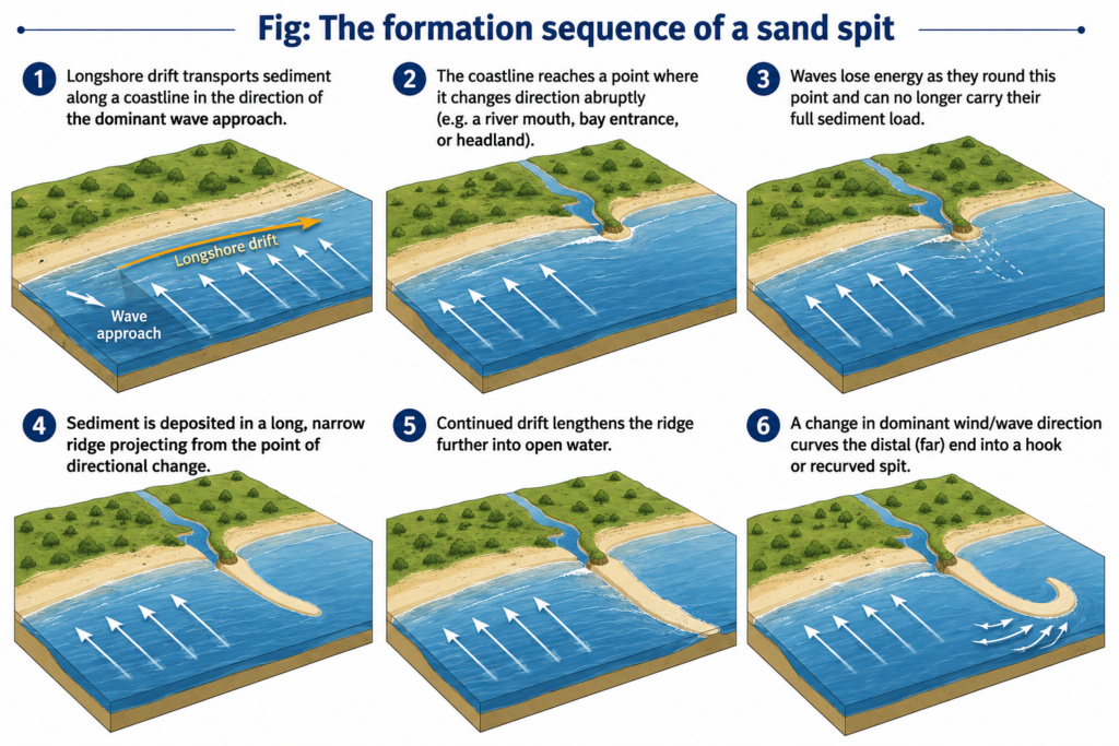
- A spit begins wherever longshore drift meets an abrupt change in coastline orientation — most commonly a river mouth, the entrance to a bay, or the tip of a headland — because the sediment-carrying current, having followed the coast up to that point, continues moving in roughly the same direction even after the coastline itself turns away, causing it to lose contact with the shore and deposit its load in open water rather than following the new coastline angle.
- As longshore drift continues supplying sediment, the deposited ridge is progressively extended further out into open water, growing a free-standing, narrow embankment of sand or shingle that remains attached to the mainland at one end (the proximal end) while its outer (distal) end remains unattached, exposed to wave and current action from multiple directions.
- A recurved (hooked) spit forms where a secondary, less dominant wave or wind direction periodically redirects deposition at the exposed distal end, curving it back toward the land — producing the classic hook shape seen in many mature spits, sometimes with multiple recurves recording successive shifts in the dominant wave direction over the spit’s growth history.
- Because a spit shelters the water behind it from open-sea wave energy, that sheltered zone becomes a low-energy environment where fine silts settle out, commonly developing into a salt marsh or mudflat behind the spit — meaning a spit’s formation typically also initiates a second, complementary depositional environment on its landward side.
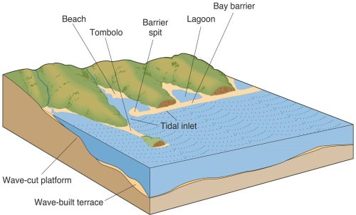
- Where a spit grows long enough to extend across an entire bay and connect two headlands on either side, it becomes a bar, and the shallow body of water trapped behind it becomes a lagoon — showing that “spit,” “bar,” and “barrier” are best understood as points along a single continuum of longshore-drift-built ridges, distinguished mainly by how far the deposition has progressed and what it ultimately connects.
- Dhanushkodi, at the southeastern tip of Rameswaram Island in Tamil Nadu, is a well-known Indian example of a sand spit — a narrow, elongated sandy tongue extending toward Sri Lanka, built by longshore drift operating along the Palk Strait/Gulf of Mannar coastline and periodically reshaped by storm activity, including the 1964 cyclone that devastated the settlement once located on it.
Tombolo Formation: When a Spit Reaches an Island
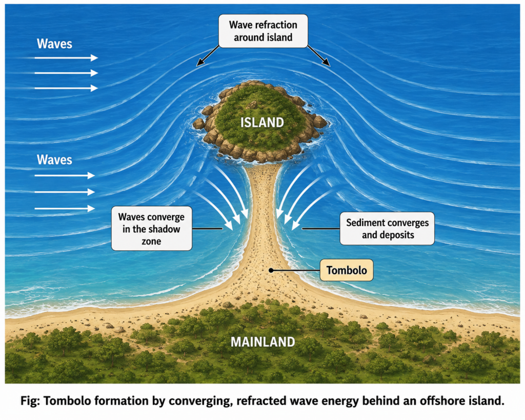
- A tombolo is a sandy or shingle ridge (sometimes described as a sandy isthmus) that connects an offshore island to the mainland, or connects two islands to one another, formed by exactly the same longshore-drift deposition process that builds an ordinary spit — the defining difference is simply that an island lies close enough offshore for the depositional ridge to reach and connect to it.
- The most common mechanism is wave refraction around an offshore island: as waves approach the island, they bend (refract) around both sides of it, and this bending concentrates and redirects longshore sediment transport from both directions toward the “wave-shadow” zone directly behind the island, where wave energy is lowest — sediment converging from both sides is deposited preferentially in this sheltered zone, gradually building a connecting ridge.
- Over time, continued deposition in this wave-shadow zone extends the ridge until it physically bridges the gap between island and mainland, at which point the former island becomes a tied island, permanently or seasonally attached to the mainland by the tombolo.
- “Sometimes, islands are connected with mainland by a bar called tombolo” — the essential one-line definition capturing the outcome of this process.
- Where the connecting ridge is instead built between two separate islands rather than between an island and the mainland, the resulting feature is distinguished with its own name — a dumb-bell (or “dumb ball”) formation — reflecting the same wave-refraction-driven convergent deposition operating symmetrically between two offshore obstacles rather than between one obstacle and the coast.
- Because a tombolo depends on a specific, favourable geometric relationship between an island’s position, size, and the coastline’s wave-approach pattern, tombolos are less common than ordinary spits — spit formation requires only a change in coastline direction, which occurs frequently along any drift-affected coast, whereas tombolo formation requires an offshore island positioned close enough, and in the right relationship to the dominant wave-refraction pattern, for a connecting ridge to actually reach it.
- Classic global tombolo examples include Monte Argentario, connected to the Italian mainland by twin tombolos enclosing the Orbetello lagoon, and Chesil Beach-type shingle structures along the English coast; a partial, low-lying sand connection historically linking Pamban Island to the Tamil Nadu mainland near Rameswaram before the construction of the Pamban rail bridge illustrates the same tombolo-forming process operating along the Indian coastline.
Common Ground and Key Distinction
- Both landforms depend on three shared preconditions: an abundant supply of sediment (from river input, cliff erosion, or offshore sources), a dominant, sustained direction of wave approach capable of driving longshore drift, and a stretch of relatively sheltered, shallow water in which the transported sediment can actually settle rather than being continually re-suspended and carried further.
- The decisive distinguishing factor is simply what lies at the point of reduced wave energy where deposition concentrates: open water with no nearby obstacle produces a free-standing spit (which may recurve into a hook, or extend into a full bar across a bay), while a nearby offshore island redirects and concentrates the same deposition process into a tombolo connecting island to mainland.
- Both landforms are inherently dynamic rather than permanent — because they depend on a continuing, directionally consistent sediment supply, a change in storm-wave direction, a reduction in sediment supply (for instance from upstream river damming), or accelerated sea-level rise can erode, breach, or reshape either a spit or a tombolo over time, making both landforms valuable, sensitive indicators of ongoing changes in a coastline’s sediment budget.
- Spits and tombolos are, at bottom, the same longshore-drift-driven depositional process expressed in two different coastal geometries: a change in coastline direction produces a free-standing spit, while a nearby offshore island redirects the same process into a connecting tombolo.
- Reading either landform on a map is therefore also reading the direction of the dominant longshore drift that built it, since both the spit’s axis and a recurved spit’s hook, or a tombolo’s precise alignment relative to its island, directly record the wave-approach pattern responsible for their formation.
- Because both remain actively maintained by ongoing sediment supply, they are also early indicators of coastal sediment-budget disruption — making their continued monitoring, from Dhanushkodi’s storm-reshaped spit to any tombolo-linked settlement, a live concern for coastal management rather than a purely descriptive geomorphological curiosity.