

“Write an essay on the evolution of continents and oceans using various theories and models.” (2020)
- The question of how continents and oceans came to occupy their present form has been answered by a succession of theoretical frameworks, each building on, reacting against, or being absorbed into the next — from the nineteenth-century contraction theories of Kober and Jeffreys, through Hall and Dana’s geosynclinal theory (1873 onward), to Alfred Wegener’s continental drift (1912), Dutton’s isostasy (1889), Arthur Holmes’s mantle convection hypothesis (1930s), Harry Hess’s sea floor spreading (1960), and finally the synthesised modern theory of plate tectonics (Morgan and Wilson, 1962–67).
- No single theory in this sequence was simply discarded and replaced by the next — each surviving idea was absorbed, corrected, or given a missing mechanism by its successor, so that plate tectonics today functions less as a wholly new theory than as the accumulated, corrected synthesis of everything that came before it.
- The thesis argued here: tracing the evolution of continents and oceans through these successive models is itself the best way to understand why plate tectonics is structured the way it is — every one of its core postulates (a mobile crust, isostatic equilibrium, convective driving force, oceanic spreading and subduction) exists specifically because an earlier theory identified the right observation but proposed the wrong mechanism, and a later theory supplied the correction.
The Contractionist Beginning: Cooling, Shrinking, and Folding
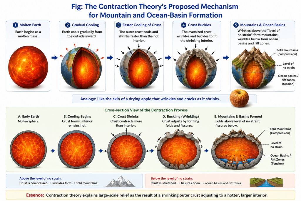
- Kober’s geosynclinal-orogen theory treated ancient rigid continental masses (kratogens) as the foundation of the continents, with mountains formed where the compressive force of earth-contraction pushed these rigid forelands together, squeezing the intervening geosyncline (orogen) into folds — a mechanism J.A. Steers (1932) summarised bluntly: “Kober is definitely a contractionist, contraction providing the motive force for the compressive stress.”
- Harold Jeffreys’s thermal contraction theory refined this into a layered model: because the earth’s uppermost layers cool and contract faster than the hot interior below, the outer crust is forced to buckle and fold above a migrating “level of no strain,” producing compressional mountain belts above it and tensional fissures (proto-ocean basins) below it.
- John Joly’s radioactivity theory (1925) tried to rescue contraction from a fatal weakness — that the earth should long since have exhausted its cooling heat — by proposing cyclical reheating from radioactive decay in sialic rocks, periodically remelting the sima and triggering fresh episodes of crustal readjustment.
- All three contraction models were eventually abandoned for the same reason: the compressive force a shrinking, cooling earth could plausibly generate was many orders of magnitude too weak to raise mountain systems on the scale of the Alps or Himalaya, and contraction could not explain why fold belts trend east-west in some ranges (the Alpine-Himalayan belt) but north-south in others (the Rockies and Andes) — a directional inconsistency no single, uniform global shrinkage could account for.
The Geosynclinal Theory: Where Continents and Oceans Meet
- James Hall and James Dana’s geosynclinal theory, developed from Hall’s study of the northern Appalachians, established that folded mountain belts originate as thick sedimentary accumulations in long, narrow, slowly subsiding marine troughs — geosynclines — where sediment deposition kept pace with crustal subsidence over immense spans of geological time before eventual uplift and folding produced a mountain range.
- Emile Haug extended this into a genuinely global framework, mapping five major Mesozoic landmasses (North Atlantic, Sino-Siberian, Africa-Brazil, Australia-India-Madagascar, and Pacific) separated by four great geosynclines (Rockies, Ural, Tethys, and Circum-Pacific) — directly anticipating the idea that today’s continents and oceans occupy positions inherited from a very different Mesozoic arrangement of land and sea.
- Hans Stille’s classification divided the crust into stable cratons and mobile orthogeosynclines (further split into volcanically-active eugeosynclines and quieter miogeosynclines), a distinction later reinterpreted in plate-tectonic terms as, respectively, the deformed remnants of small ocean basins and the deformed remnants of former continental margins — showing how thoroughly a pre-plate-tectonic classification could still map onto the plate-tectonic picture once the underlying mechanism was understood decades later.
- Geosynclinal theory’s genuine and lasting contribution was establishing that oceans and continents are not fixed categories — the Tethys geosyncline, once a marine trough between Gondwanaland and Laurasia, became the Alpine-Himalayan mountain system, a transformation of ocean into continent-bound mountain belt that no contraction theory alone could explain, but which continental collision under plate tectonics later would.
Continental Drift: Continents in Motion, Without a Motor
- Alfred Wegener’s continental drift theory (1912) proposed that all continents were once assembled into a single supercontinent, Pangaea, surrounded by the ocean Panthalassa, which began breaking apart roughly 200 million years ago — the fragments drifting, equatorward and westward in Wegener’s account, to their present positions.
- His evidence remains foundational to every later theory: the “jigsaw fit” of the Atlantic coastlines; matching geological structures (the Appalachians continuing into the old Hercynian ranges of Ireland, Wales, and central Europe); shared Permo-Carboniferous glacial deposits across Brazil, South Africa, peninsular India, and Australia; and matching fossil distributions of terrestrial organisms on now-separated coasts.
- “How could tropical ferns have grown in London, Paris, Bonn, and even in Greenland?” — the puzzling climatic-belt anomaly that first led Wegener toward the drift hypothesis.
- Wegener resolved this by concluding it was the landmasses, not the climatic belts, that had shifted — since climatic zones are fixed by the sun’s position relative to the earth’s tilt and could not plausibly have moved instead.
- The theory’s fatal weakness was mechanism: Wegener attributed equatorward drift to the earth’s rotational/equatorial bulge and westward drift to lunar-solar gravitational pull, forces critics correctly showed were far too weak to move solid continents through equally solid oceanic crust — continental drift told geologists that continents had moved, but not how, leaving the theory unable to explain the formation of oceanic ridges or island arcs and largely dismissed for several decades.
Isostasy: The Floating-Crust Principle That Would Complete the Puzzle
- Clarence Dutton’s isostasy (1889) established, from a real anomaly in the Himalayan gravity survey conducted under Sir George Everest, that the crust behaves as blocks in buoyant equilibrium rather than as a rigid, immovable shell — Sir George Airy explained this via a “floating” crust with mountain ranges possessing deep compensating roots, while Archdeacon Pratt proposed instead that compensation came from lateral density variation at a uniform depth.
- Isostasy, on its own, addressed only vertical equilibrium — a crustal block rising or sinking to maintain balance — and said nothing about lateral (horizontal) continental movement, meaning it could not, by itself, resolve continental drift’s central claim; but it firmly established the floating-crust principle that plate tectonics would later restate in terms of the lithosphere floating on the asthenosphere.
Convection, Sea Floor Spreading, and Paleomagnetism: Supplying the Missing Mechanism
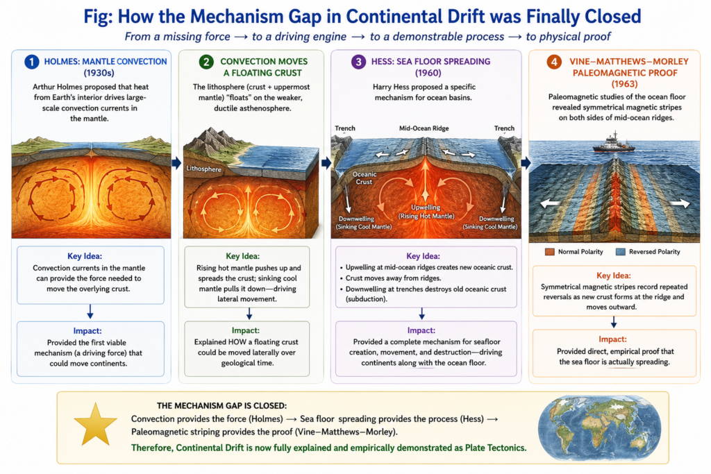
- Arthur Holmes, in the 1930s, proposed that radioactive heating in the mantle drives slow convection currents — a mechanism finally capable of dragging a floating crust laterally rather than merely letting it bob vertically, directly answering continental drift’s unresolved “how.”
- Harry Hess’s sea floor spreading hypothesis (1960) gave Holmes’s convection idea a testable, physical form: new oceanic crust forms continuously at mid-ocean ridges where convective upwelling occurs, and is destroyed at deep-ocean trenches where convective downwelling drags older crust back into the mantle through subduction — explaining, for the first time, both oceanic ridges and island arcs, the two features contraction and drift theories alike had failed to account for.
- Paleomagnetic evidence — symmetrical, mirror-imaged stripes of alternating magnetic polarity flanking mid-ocean ridges, formalised as the Vine-Matthews-Morley hypothesis (1963) — supplied the decisive proof: rock ages increase systematically with distance from a ridge axis, demonstrating directly that the ocean floor itself spreads outward, carrying the continents passively along with it exactly as Wegener’s drift required.
- Deep Sea Drilling Project core samples independently confirmed the same pattern through direct dating, while J. Tuzo Wilson’s identification of transform faults (1965) explained the offset geometry of mid-ocean ridges as a natural consequence of spreading on a curved planetary surface.
Plate Tectonics: The Synthesis, and Its Modern Extensions
- W.J. Morgan formally advanced plate tectonics in 1962, with J. Tuzo Wilson providing the theory’s name; the theory replaced isostasy’s older sial/sima classification with the mechanically-defined lithosphere (rigid crust and uppermost mantle, “floating” on the layer below) and asthenosphere (the plastic layer it slides upon), and identified three plate boundary types — divergent (constructive, e.g. the Mid-Atlantic Ridge and the East African Rift), convergent (destructive, e.g. the ongoing India-Eurasia collision still raising the Himalaya, and Andean oceanic-continental subduction), and transform (conservative, e.g. California’s San Andreas Fault) — that together explain essentially every major landform contraction, geosynclinal, and drift theories could not.
- Modern refinements extend this synthesis further: the Wilson Cycle describes ocean basins opening and closing in a repeating supercontinent cycle — rifting (East African Rift today), spreading (Atlantic Ocean today), subduction and narrowing (Pacific Ocean today), and eventual continental collision (the Himalaya today) — showing that the Tethys-to-Himalaya transformation geosynclinal theory first documented is not a one-off event but part of a recurring planetary rhythm stretching back through multiple past supercontinents (Rodinia, Pangaea) and forward toward hypothesised future ones.
- Mantle plume and hotspot theory — visible in the progressively aging Hawaiian-Emperor seamount chain — supplies a further refinement Hess’s original spreading model did not fully anticipate: some volcanic and continental rifting activity is driven by localised, deep-mantle plumes largely independent of plate-boundary processes, a mechanism increasingly invoked alongside convection to explain intraplate volcanism and the initial rifting phase of continental breakup.
- Present-day GPS geodesy, measuring the Indian plate’s continued northward convergence with Eurasia at a few centimetres per year, offers living, real-time confirmation of the same continental movement Wegener first inferred purely from a coastline fit — closing the loop from a 1912 hypothesis based on a single observation to a theory now measured directly, continuously, and globally.
- The evolution of continents and oceans has therefore been explained by a chain of theories in which each successor did not simply overturn its predecessor but corrected its central weakness: contraction theory’s compressive force was too weak, so geosynclinal theory refined where mountains form; continental drift proved that continents moved but not how; isostasy proved the crust could float but not move laterally; and mantle convection, sea floor spreading, and paleomagnetism together supplied the missing mechanism that plate tectonics finally unified into one coherent theory.
- Reading this sequence chronologically also reveals a shift in the kind of evidence each theory relied upon — from Kober and Jeffreys’s largely deductive physical reasoning, through Hall and Wegener’s comparative geological and biogeographic evidence, to Hess and Vine-Matthews’s directly measured paleomagnetic and radiometric data — a maturation from speculative model-building toward an empirically verified theory.
- Because plate tectonics itself continues to be extended (the Wilson Cycle, mantle plume theory, GPS-measured plate motion), the evolution of continents and oceans remains an open rather than closed chapter of geological theory, with the same iterative logic — observation outrunning mechanism, and mechanism eventually catching up — likely to keep refining the picture further.