

“Why is mapping important for analyzing geo-hydrological investigations? Explain with relevant examples.” (2020)
- Geo-hydrological (hydrogeological) investigation is the study of the occurrence, movement, and quality of surface and subsurface water as controlled by geology and landform, and D.K.C. Jones’s definition of applied geomorphology — “the application of geomorphic understanding to the analysis and solution of problems concerning land occupancy, resource exploitation, and environmental management and planning” — captures exactly why mapping sits at the centre of this investigation: water availability cannot be assessed from a single point measurement, only from the spatial pattern of rock type, structure, slope, and drainage across an entire area.
- Charley, Schumm, and Sugden’s classification of applied geomorphology into two lines of application places “production of maps for hydrological, erosional and stability control” and “geomorphic mapping” explicitly within the resource-evaluation strand of the discipline, underscoring that mapping is not a supplementary illustration of a geo-hydrological study but one of its core analytical tools.
- The thesis argued here: mapping is indispensable to geo-hydrological investigation because groundwater and surface water behaviour is fundamentally a spatial phenomenon — controlled by lithology, structure, permeability, and topography that vary continuously across a landscape — so that only a map, whether hand-drawn from field survey or generated from satellite and GIS data, can capture the areal pattern needed to locate water, predict its movement, and manage the hazards associated with it.
Why Point Data Alone Cannot Answer a Geo-Hydrological Question
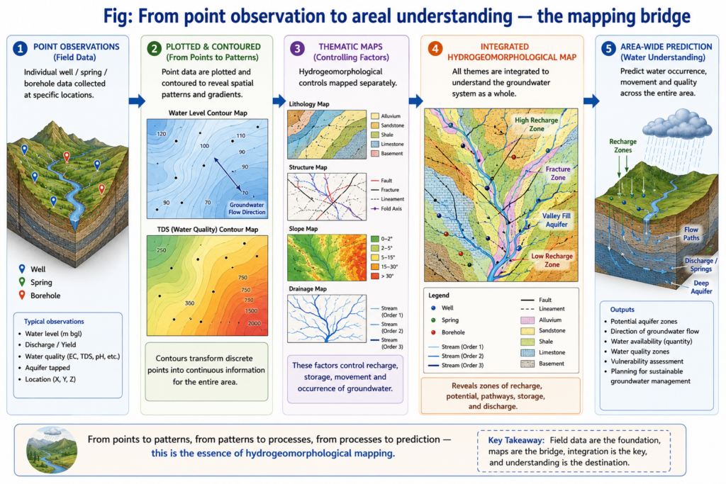
- Groundwater occurrence depends on lithological and structural variation that differs from one location to the next within the same small area — different stratigraphic and lithological zones present entirely different conditions of surface and groundwater, so a single borehole log tells an investigator almost nothing about a site even a short distance away without a map connecting the two.
- Permeability itself is not uniform even within one rock type: in limestone terrain, primary permeability (from original interconnected pore spaces) and secondary permeability (acquired through faulting, folding, warping, or solutional widening) vary sharply with structure and topographic position, being greatest beneath and adjacent to topographic lows — a pattern that only becomes visible once permeability, structure, and topography are all mapped together over the same area.
- Because groundwater generally moves down rather than up the regional dip, understanding subsurface flow direction requires a structural map showing the orientation of rock beds across the investigation area, not just their composition at any one borehole — making structural mapping a direct prerequisite for predicting which direction contamination or a pollutant plume will travel.
Mapping Karst and Limestone Terrain for Water Supply
- Karst hydrogeology depends almost entirely on mapped features: because groundwater in karst terrain is confined largely to solutionally-opened passageways rather than distributed through the rock mass, locating swallow holes, sinkholes, and springs on a map is the only way to reconstruct the underground drainage system connecting them.
- “The sources of the spring water should be determined in such a case of pollution” — the standard operating principle behind karst water-tracing investigations.
- This is done in practice through dye-tracing: colouring material such as fluorescein is introduced into water entering a mapped swallow hole, and the various springs in the area are then tested to confirm which one it emerges from — a technique that is entirely dependent on first having mapped the candidate sinkholes and springs across the terrain.
- Whether a limestone aquifer yields safe water also depends on mapped stratigraphic relationships: limestone capped by a sandstone layer filters percolating water naturally and can yield high-volume wells, whereas dense, compact limestone with little primary permeability forces water through secondary openings alone, producing low or contamination-prone yields — a distinction that can only be assessed by mapping the vertical and lateral extent of the capping and aquifer units together.
- India’s own karst belts (parts of the Vindhyan and Cuddapah limestone tracts, and the cave-bearing terrain of Meghalaya) illustrate this directly — hydrogeological mapping of sinkhole and spring distribution in such regions is standard practice before any rural water-supply scheme is designed, precisely because point-based test drilling alone cannot reveal where the solution channels that actually carry the water lie.
Mapping Glaciated Terrain and Buried Valleys
- In glaciated regions, groundwater potential correlates directly with mapped landform type: outwash plains, valley trains, and intertill gravels are likely to yield large volumes of water, while most till is a poor aquifer because of its clay content, except where local sand-and-gravel lenses occur within it — information only a landform (geomorphic) map can convey at the scale needed for site selection.
- Buried preglacial and interglacial valleys — often the single best groundwater source in a glaciated landscape — can only be located by constructing a bedrock topography map, reconstructing the pre-glacial land surface concealed beneath younger glacial deposits, since no surface expression of the buried valley survives to be observed directly in the field.
- This is a clear demonstration of mapping doing analytical work that point observation cannot replicate at all: the buried valley is invisible at the surface, and its presence or absence can be established only by the interpretive act of mapping subsurface structure across a wide area, not by drilling a series of isolated, unconnected boreholes.
Modern Mapping Tools: Remote Sensing and GIS in Geo-Hydrology
- Remote sensing — the collection of information about the earth’s surface via sensors without direct contact — has transformed geo-hydrological mapping because a single satellite dataset can simultaneously serve multiple specialists: the same imagery used by soil scientists for soil surveys and by agricultural scientists for crop assessment is equally used by geohydrologists for groundwater surveys, since lineaments, drainage density, and land cover visible in the imagery are all direct proxies for subsurface water conditions.
- Geographic Information Systems (GIS), layered on top of remote sensing data, allow multiple thematic maps — slope, lineament density, lithology, drainage density, land use, and overburden thickness — to be overlaid and analysed together, producing an integrated hydrogeomorphological map that identifies groundwater potential zones far more efficiently than field survey alone.
- India’s National Aquifer Mapping Programme (NAQUIM), administered by the Central Ground Water Board, is a direct large-scale application of this principle: multi-criteria GIS analysis combining geology, structural lineaments, hydrogeomorphology, and rainfall data is used to classify terrain into groundwater potential zones (poor, moderate, good, very good) across river basins nationwide, guiding both aquifer management and participatory groundwater schemes at the command-area level.
- Remote sensing mapping also carries clear operational advantages for geo-hydrological work specifically: it offers a synoptic, wide-area view impossible from scattered ground surveys, produces a permanent, re-verifiable record, and can be repeated over time far more economically than repeated ground campaigns — directly relevant where an aquifer’s water table or a river’s channel migration needs to be monitored across successive seasons rather than assessed once.
Mapping for Flood, Hazard, and Engineering Applications in Geo-Hydrology
- Flood control decisions depend on mapped catchment characteristics: without knowledge of upper-catchment erosion rates and sediment-load patterns — itself a mapping exercise correlating slope, land cover, and channel morphology — engineering interventions such as levee construction can prove disastrous, since high sediment supply from an unmapped upper catchment can raise the riverbed within an embanked reach and trigger sudden flash floods when the levee is eventually breached.
- Reservoir and dam-site investigations similarly rely on geological and geomorphic mapping to assess the five main site requirements (adequate storage capacity, watertight basin geology, structural stability of the foundation, an assured reservoir lifespan against sedimentation, and a suitable dam-axis location) — an assessment that is inherently a comparison across mapped alternative sites rather than an evaluation of one location in isolation.
- Terrain stability mapping — identifying unstable hill slopes and their associated lithologies — directly protects geo-hydrological infrastructure itself, since knowledge of slope stability is what allows planners to avoid siting settlements, roads, or water-supply works on ground prone to landslides or subsidence triggered by the very water-extraction or reservoir-construction activity the investigation is meant to support.
- Geo-hydrological investigation is, at its foundation, a spatial problem — where water occurs, how it moves, and how safe it is to use all vary continuously across an area rather than existing as isolated point facts — and mapping is the only analytical tool that captures and communicates that spatial variation in a form usable for decision-making.
- From dye-tracing sinkholes in karst terrain to reconstructing buried glacial valleys through bedrock topography maps, every classical geo-hydrological technique is fundamentally an exercise in constructing and interpreting a map rather than reading a single measurement.
- Modern remote sensing and GIS-based hydrogeomorphological mapping, exemplified by India’s aquifer-mapping programme, have not replaced this logic but scaled it up — turning what was once slow, point-by-point field survey into rapid, area-wide, repeatable maps that remain the indispensable foundation of any serious geo-hydrological investigation today.