Q. Which of the following phenomena might have influenced the evolution of organisms?
- Continental drift
- Glacial cycles
Select the correct answer using the codes given below
(a) 1 only
(b) 2 only
(c) Both 1 and 2
(d) Neither 1 nor 2
Answer: (c) Both 1 and 2
Continental drift theory
- Continental drift is the hypothesis that the Earth’s continents have moved over geologic time relative to each other, thus appearing to have “drifted” across the ocean bed.
- Continental drift theory deals with the distribution of the oceans and the continents.
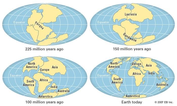
- According to the theory, all the continents formed a single continental mass- Pangea and mega ocean- Panthalassa surrounded it.
- Pangaea started splitting and broke down into two large continental masses as Laurasia and Gondwanaland forming the northern and southern components respectively.
- Subsequently, Laurasia and Gondwanaland continued to break into various smaller continents that exist today.
- The Continental drift must have moved some animals from one continent to others and few getting stuck in the same place, which must have influenced the evolution.
Glacial cycles
- A glacial period (alternatively glacial or glaciation) is an interval of time (thousands of years) within an ice age that is marked by colder temperatures and glacier advances.
- Interglacials, on the other hand, are periods of warmer climate between glacial periods.
- Glacial cycles would affect evolution as many might not able to tolerate extreme cold and would have extincted.
- The rise in sea level due to glacial melt also might have affected the evolution of organisms.
Q. In India, the problem of soil erosion is associated with which of the following?
- Terrace cultivation
- Deforestation
- Tropical climate
Select the correct answer using the codes given below
(a) 1 and 2 only
(b) 2 only
(c) 1 and 3 only
(d) 1, 2 and 3
Answer: (b) 2 only
Soil erosion
- Soil erosion is the removal of the topmost fertile layer of the soil through wind or water.
- Causes of Soil Erosion:
- Over-grazing, Deforestation, Action of wind, water, glacier, etc.
- Topography i.e steep slopes & heavy rainfall;
- Faulty methods of agriculture like over-irrigation, shifting agriculture, etc;
- Anthropogenic factors like mining, industrial activities, etc.
Terrace farming
- Terrace farming, contour ploughing, etc are the measures to control soil erosion.
- Terrace farming is an agricultural practice farmers employ on steep slopes, hilly areas, and higher altitudes.
- Terrace farmers construct successive layers of flat areas on mountainsides or other terrains with steep inclines to better control soil conservation and runoff water.
- These levels look like staircase steps and create more apparent segments of arable land without harming the surrounding ecosystem.
- Advantages of Terrace Farming
- Improved land productivity: Without terrace farming, much of a hillside would be unusable as farmland. Terrace farming makes these areas fertile.
- Increased food security: Terracing gives farmers more control over the land they till and the water it receives. This increases food security by guaranteeing safer growing conditions.
- Maximized crop production: Runoff can go to the base of a mountain, but terraces prevent the water from moving beyond a single layer. This puts the water to better use and maximizes crop production.
- Prevention of soil erosion: Rainfall takes soil with it, leading to erosion. Terrace farming mitigates the effects of erosion by slowing water runoff and trapping it in individual layers along the incline.
Deforestation
- Deforestation or forest clearance is the removal of a forest or stand of trees from land that is then converted to non-forest use.
- Deforestation can involve conversion of forest land to farms, ranches, or urban use. The most concentrated deforestation occurs in tropical rainforests.
- About 31% of Earth’s land surface is covered by forests at present.
Q. The seasonal reversal of winds is the typical characteristic of
(a) Equatorial climate
(b) Mediterranean climate
(c) Monsoon climate
(d) All of the above climates
Answer: (c) Monsoon climate
Monsoon type of climate
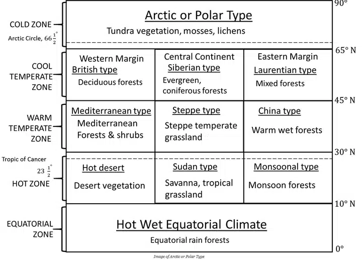
- It is best developed in the Indian subcontinent, Myanmar, Thailand, Laos, Cambodia, parts of Vietnam, and south china and northern Australis.
- This type of climate is characterized by the onshore wet monsoon in summer and offshore dry monsoon in winter.
- The basic cause of monsoon climates is the difference in the rate of heating and cooling of land and sea.
- Monsoon refers to the seasonal reversal in the wind direction during a year.
- The monsoon type of climate is characterized by a distinct seasonal pattern.
Equatorial type of climate
- Equatorial type of climate is found in the Amazon basin in South America, Congo basin in Africa, Guinea coast in Africa, and much of the Indo-Malaysian region, eastern Central America, some islands in the Caribbean Sea, western Colombia, and eastern Madagascar.
- This type of climate is located till 5 degrees to 10 degrees on either side of the equator.
Warm Temperate Western Margin Climate
- It is also called a Mediterranean type of climate because most of the areas falling under this climate are situated around the Mediterranean Sea.
- This climate has developed between 300C and 450C latitudes in both the hemispheres in the western part of the continents.
- The climate of Central Chile is of temperate Mediterranean type of climate.
- This climate region includes Southern Italy, Greece, Western Turkey, Syria, Lebanon, Western Israel, North Coastal Africa, central and Southern California in the USA, Central Chile in South America, Cape Town area in South Africa, and the coastal zones of Southern and Southwest Australia.
Must Read: Climatic Regions of World
Q. Consider the following statements:
- Maize can be used for the production of starch.
- Oil extracted from maize can be a feedstock for biodiesel.
- Alcoholic beverages can be produced by using maize.
Which of the statements given above is/are correct?
(a) 1 only
(b) 1 and 2 only
(c) 2 and 3 only
(d) 1, 2 and 3
Answer: (d) 1, 2 and 3
Notes:
- Maize starch is produced by the wet milling process, which involves the grinding of softened maize and separation of corn oil seeds (germs), gluten (proteins), fibers (husk), and finally pure starch.
- Corn starch is made from maize kernels, which are high in starch.
- Corn starch has a wide variety of applications. It is used as a thickening agent in soups.
- Corn starch is also used in manufacturing bio-plastics and the preparation of corn syrup.
- The general way to Produce Biodiesel fuels is transesterification of fat or oil triacylglycerols with short-chain alcohol such as methanol or ethanol in the presence of alkaline or acid catalysts.
- Corn Biodiesel chemically is a mixture of long-chain fatty acid methyl esters (FAMEs).
- Oil extracted from maize that can be converted into ethanol or biodiesel.
- The type of alcohol in the alcoholic drinks we drink is a chemical called ethanol. To make alcohol, you need to put grains, fruits, or vegetables through a process called fermentation, the common source of ethanol is maize and other grains.
Q. What are the significances of a practical approach to sugarcane production known as ‘Sustainable Sugarcane Initiative’?
- Seed cost is very low in this compared to the conventional method of cultivation.
- Drip irrigation can be practiced very effectively in this.
- There is no application of chemical inorganic fertilizers at all in this.
- The scope for intercropping is more in this compared to the conventional method of cultivation.
Select the correct answer using the code given below.
(a) 1 and 3 only
(b) 1, 2 and 4 only
(c) 2, 3 and 4 only
(d) 1, 2, 3 and 4
Answer: (b) 1, 2 and 4 only
Sustainable Sugarcane Initiative
- Sustainable Sugarcane Initiative is a credit plus approach by NABARD that integrates twin drip irrigation systems in sugarcane cultivation.
- Sustainable Sugarcane Initiative aims at cultivating sugarcane mainly by changing the way the inputs and methods are used.
- It majorly involves
- Less use of seeds
- Less user of water
- Optimum utilization of fertilizers and land
- It aims at reducing the input cost.
- Its basic premise is to obtain “more with less” in agriculture.
- SSI cultivation increases crop yield by 20-30%.
- It brings down the cost up to 75%.
- It reduces plant mortality rate; helps in increasing the length and weight of cane.
- There is the scope of intercropping and the drip irrigation method can also be used.
- However, SSI is a farmer-driven method; and its advantages are dependent on the efforts of the cultivator himself rather.
- It aims to create jobs for women and men in rural areas in the seedling manufacturing process.
- This scheme uses funds to subsidise the cost of seedlings and hold educational campaigns for farmers for awareness.
- This technique helps save large quantities of water up to 940,000 m3 annually.
- SSI aims to promote sustainable farming techniques among 20,000 farmers in five years.
- A farmer can save up to Rs.88,000 per acre by implementing SSI techniques.
- Individuals can bring down water usage and save up to 50% for environmental protection.
Q. Consider the following pairs
Region : Well-known for the production of
1. Kinnaur : Areca nut
2. Mewat : Mango
3. Coromandel : Soya bean
Which of the above pairs is/are correctly matched?
(a) 1 and 2 only
(b) 3 only
(c) 1, 2 and 3
(d) None
Answer: (d) None
Notes:
- Kinnaur
- It is a district in Himachal Pradesh.
- According to the 2011 census, Kinnaur district has a population of 84,121.
- It is mostly famous for apples.
- The production of Areca nuts is mostly confined to Karnataka, Kerala and Assam.
- Mewat
- It is a district in Haryana.
- The main occupation is agriculture along with allied and agro-based activities.
- It is not primarily famous for Mango.
- Coromandel
- It is a coastal plain in the eastern Tamil Nadu state.
- Rice, pulses, sugarcane, cotton, and peanuts are primarily grown in this region.
- The production of soybean in India is dominated by Maharashtra and Madhya Pradesh which contribute 89 per cent of the total production.
Q. Consider the following pairs:
Programme/Project : Ministry
- Drought-Prone Area Programme : Ministry of Agriculture
- Desert Development Programme : Ministry of Environment and Forests
- National Watershed Development Project for Rainfed Areas : Ministry of Rural Development
Watershed Development project Development for Rainfed Areas Which of the above pairs is/are correctly matched?
(a) 1 and 2 only
(b) 3 only
(c) 1, 2 and 3
(d) None
Answer: (d) None
Notes:
- The Drought-Prone area Programme comes under the Ministry of Rural Development.
- This programme aims to mitigate the impacts of droughts on crop production, livestock, land and water resources.
- The Desert Development Programme comes under the Ministry of Rural Development.
- The basic objective of the Desert Development Programme is to minimise the adverse effect of drought and control desertification through rejuvenation of the natural resource base of the identified desert area.
- The National Watershed Project for rainfed areas implemented by the Ministry of Agriculture is an umbrella scheme under the Pradhan Mantri Krishi Sinchayi Yojana.
- The initiative aims to enhance water availability in the watershed areas.
Q. Consider the following pairs:
National Highway Cities connected
- NH4 : Chennai and Hyderabad
- NH 6 : Mumbai and Kolkata
- NH 15 : Ahmedabad and Jodhpur
Which of the above pairs is/are correctly matched?
(a) 1 and 2 only
(b) 3 only
(c) 1, 2 and 3
(d) None
Answer: (d) None
| National Highway | Cities connected |
|---|---|
| 1. NH 4 | Mayabandar-Port Blair-Chiriyatapu (Andaman) |
| 2. NH 6 | Jorabat (Meghalaya) – Selling (Mizoram) |
| 3. NH 15 | Baihat(Assam)-Wakro(Arunachal Pradesh) |
Also Read: Important National Highways in India
Q. What are the benefits of implementing the ‘Integrated Watershed Development Programme’?
- Prevention of soil runoff
- Linking the country’s perennial rivers with seasonal rivers
- Rainwater harvesting and recharge of groundwater table
- Regeneration of natural vegetation
Select the correct answer using the code given below.
(a) 1 and 2 only
(b) 2, 3 and 4 only
(c) 1, 3 and 4 only
(d) 1, 2, 3 and 4
Answer: (c) 1, 3 and 4 only
Integrated Watershed Management Programme (IWMP)
- The Integrated Watershed Management Programme (IWMP), one of the Flagship programmes of the Ministry of Rural Development is under implementation by the Department of Land Resources since 2009-10 after integrating three area development programmes namely
- Desert Development Programme (DDP)
- Drought Prone Areas Programme (DPAP)
- Integrated Wastelands Development Programme (IWDP)
- The main objectives of the IWMP are to restore the ecology balance by harnessing conserving and developing degraded natural resources such as soil, vegetative cover and water.
- The outcomes are prevention of soil run off, regeneration of natural vegetation rain water harvesting and recharging of ground water table.
- This enables multi-cropping and the introduction of diverse agro based activities, which help to provide sustainable, livelihoods to the people.
- The program is being implemented in all the states of the country and is financed by the central and state governments in the ratio of 90:10.
- In 2015, the IWMP along with On-Farm Water Management (OFWM) scheme and Accelerated Irrigation Benefit Programme (AIBP) was subsumed into Pradhan Mantri Krishi Sinchayee Yojana (PMKSY).
- Integrated Watershed Development Programme does not aim to link the country’s perennial rivers with seasonal rivers.
Q. Which one of the following pairs of islands is separated from each other by the ‘Ten Degree Channel’?
(a) Andaman and Nicobar
(b) Nicobar and Sumatra
(c) Maldives and Lakshadweep
(d) Sumatra and Java
Answer: (a) Andaman and Nicobar
Notes:
- The Andaman and Nicobarare separated by a water body which is called the Ten-degree channel.
- The Lakshadweep Islands and Maliku Atoll are separated by the Nine-degree channel.
- The Grand Channel is between the Great Nicobar islands and the Sumatra islands of Indonesia.
- Minicoy channel is a small eight-degree channel that separates Maldives and Lakshadweep.
- Sumatra and Java are separated by Sunda Strait.
Also Read: Islands of India: Andaman & Nicobar, Lakshadweep
Q. Consider the following pairs:
- Dampa Tiger Reserve : Mizoram
- Gumti Wildlife Sanctuary : Sikkim
- Saramati Park : Nagaland
Which of the above paris is/are correctly matched?
(a) 1 only
(b) 2 and 3 only
(c) 1 and 3 only
(d) 1, 2 and 3
Answer: (c) 1 and 3 only
Notes:
- The Dampa tiger reserve is located in Mizoram.
- It covers an area of about 500 km2 in the Lushai Hills at an altitude range of 800–1,100 m.
- It was declared a tiger reserve in 1994 and is part of Project Tiger.
- The tropical forests of Dampa Tiger Reserve are home to a diverse flora and fauna.
- In the tiger census of 2018, no tiger was found in this reserve. A tiger was spotted recently after seven years.
- The Gumti Wildlife Sanctuary is located in Tripura.
- It is located in South Tripura region.
- It covers an area of about 389.54 sq km.
- It is home to animals like elephants, sambar, buffalo, yapping deer, serow, wild goat, etc.
- One of the landmarks of this sanctuary is lake Dumbur, which attracted around 17 migratory bird species and 126 native bird species in the cold winters, until the number of bird visits has declined significantly in recent years.
- Saramati is a peak located in Nagaland.
- It is located near Thanamir Village in the Kiphire district of Nagaland.
- It forms a natural boundary between India and Myanmar.
Also Read:
Q. Which of the following have coral reefs?
- Andaman and Nicobar Islands
- Gulf of Kachchh
- Gulf of Mannar
- Sunderbans
Select the correct answer using the code given below.
(a) 1, 2 and 3 only
(b) 2 and 4 only
(c) 1 and 3 only
(d) 1, 2, 3 and 4
Answer: (a) 1, 2 and 3 only
Coral Reefs
- Corals are nothing but calcareous rocks, formed from the skeletons of minute sea animals, called polyps.
- The polyps extract calcium salts from seawater to form hard skeletons which protect their soft bodies. These skeletons give rise to corals.
- The corals live in colonies fastened to the rocky seafloor. New generations develop on skeletons of dead polyps. The tubular skeletons grow upwards and outwards as a cemented calcareous rocky mass collectively called corals.
- The shallow rock created by these depositions is called a reef. These reefs, later on, evolve into islands.
- The corals Occur in different forms and colours, depending upon the nature of salts or constituents they are made of.
- The progressive development of corals appears over the sea surface in different forms over a period of time. Small marine plants (algae) also deposit calcium carbonate, thus contributing to coral growth.
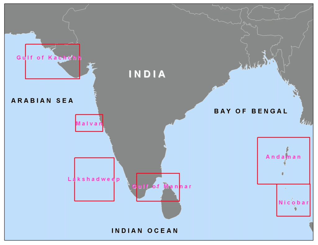
- Coral reefs in India are found in a lot of areas including the Gulf of Kutch, Gulf of Mannar, Palk Bay, Andaman & Nicobar and Lakshadweep Islands. The Gulf of Kutch in the northwest has some of the most northerly reefs in the world.
- Patches of coral reefs are also found in Ratnagiri, Malvan and Redi, south Bombay and at the Gaveshani Bank located in the west of Mangalore.

Ideal conditions for coral growth
- Corals thrive in tropical waters-between 30°N and 30°S latitudes.
- The ideal depths for coral growth are 45 m to 55 m below sea surface, where there is abundant sunlight available.
- The temperature of water should be around 20°C.
- Clear salt water is suitable for coral growth, while both fresh water and highly saline water are harmful for polyp growth.
- Adequate supply of oxygen and microscopic marine food, called plankton, is essential for growth and existence. As the food supply is more abundant on the seaward side, corals grow more rapidly on the seaward side.
Also Read: Coral Reefs & Coral Reefs Bleaching
Q. Consider the following rivers:
- Barak
- Lohit
- Subansiri
Which of the above flows/flow through Arunachal Pradesh?
(a) 1 only
(b) 2 and 3 only
(c) 1 and 3 only
(d) 1, 2 and 3
Answer: (b) 2 and 3 only
Barak River
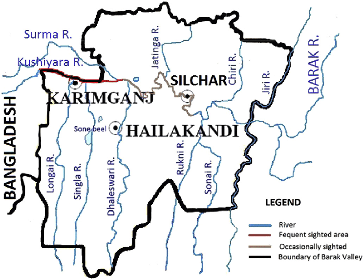
- Barak rises in the Manipur hills and enters the plains near Lakhipur, Assam
- The river enters Bangladesh as Surma and Kushiyara.
- Later, the river is called the Meghna and receives the combined flow of the Ganga and Brahmaputra.
- The principal tributaries of Barak are the Jiri, the Dhaleswari, the Singla, the Longai, the Sonai and the Katakhal.
- The Barak sub-basin drains areas in India, Bangladesh and Burma.
- The drainage area lying in India is 41723 sq.km which is nearly 1.38% of the total geographical area of the country.
- It is be on the north by the Barail range separating it from the Brahmaputra sub-basin, on the east by the Na Lushai hills and on the south and west by Bangladesh.
- Barak River flows through the states of Manipur, Nagaland, Mizoram, and Assam in India and into the Bay of Bengal
- The sub-basin lies in the States of Meghalaya, Manipur, Mizoram, Assam, Tripura and Nagaland.
- The hydropower potential of the basin is 2042 MW at 60% load factor.
Lohit River
- Lohit river is a river in Arunachal Pradesh and is a tributary of River Brahmaputra.
- It originates in eastern Tibet, in the Zayal Chu range, and surges through Arunachal Pradesh.
- The river flows through the Mishmi hills to meet the Siang at the head of Brahmaputra valley
- The valley of Lohit is thickly forested, covered with alpine and sub-tropical vegetation
- A large variety of medicinal plants are also found here.
Subansiri River
- Subansiri River is also called as Gold River as it is famous for its gold dust.
- Subansari, a swift river offers excellent kayaking opportunities.
- The Subansiri River flows through the Indian states of Assam and Arunachal Pradesh, and the Tibet Autonomous Region of China.
- It is the largest tributary of the River Brahmaputra.
- The Lower Subansiri Dam or The Lower Subansiri Hydro-Electric Project is an under construction dam gravity dam on the river.
River Brahmaputra
- It is known by the name of the Yarlung Tsangpo in the Tibet region.
- It originates in Chemayungdung glacier in the Himalayas and drains into the Bay of Bengal.
- It is about 2,900 km in length.
- After flowing through Tibet it enters India through Arunachal Pradesh and flows through Assam and Bangladesh before it joins the Bay of Bengal.
- The river crosses Assam and enters Bangladesh where the river is known as Jamuna and joins Ganga and then finally drains into the Bay of Bengal.
- Dibang River, Lohit River, Dhansiri River, Kameng River, Manas River, Teesta River, Subansiri River are the major tributaries of River Brahmaputra.

Q. Consider the following pairs:
Hills Region
- Cardamon Hills : Coromandel Coast
- Kaimur Hills : Konkan Coast
- Mahadeo Hills : Central India
- Mikir Hills : North-East India
Which of the above pairs are correctly matched?
(a) 1 and 2
(b) 2 and 3
(c) 3 and 4
(d) 2 and 4
Answer: (c) 3 and 4
Notes:
- Cardamom Hills
- These are located in Kerala and south-west Tamil Nadu.
- It is located on the south-western side of India.
- It produces tea, coffee, teak, cardamom, and bamboo.
- Anamudi is the highest peak with 2,695 meters (8,842 ft)
- Kaimur Hills
- It is the eastern portion of the Vindhya Range.
- Kaimur range is present in Madhya Pradesh, Uttar Pradesh and Bihar.
- Mahadeo Hills
- These are a range of hills in Madhya Pradesh state of central India.
- These are located in the northern part of the Satpura Range.
- Mikir Hills
- These are located to the south of the Kaziranga National Park, Assam.
- It is in north-east India and part of Karbi-Plateau.
- Dambuchko is the highest peak of Mikir Hills.
- Coromandel Coast
- It is the coastal plain in eastern Tamil Nadu state.
- It is bounded by the Utkal Plains to the north, the Bay of Bengal to the east, and the Kaveri delta to the south and the Eastern Ghats to the west, extending over an area of about 22,800 square kilometres.
- Konkan coast
- It is at the western coastline of India.
- It extends throughout the western coasts of Maharashtra, Goa and Karnataka.
Must Read: Important Hill Ranges of India
Q. If you travel through the Himalayas, you are likely to see which of the following plants naturally growing there?
- Oak
- Rhododendron
- Sandal wood
Select the correct answer using the code given below:
(a) 1 and 2 only
(b) 3 only
(c) 1 and 3 only
(d) 1, 2 and 3
Answer: (a) 1 and 2 only
Notes:
- Oak and Rhododendron are characteristic plants of the Temperate forest.
- Temperate forests are mainly found in the middle altitudes of the Himalayas.
- Oak
- Oak is a hardwood that is heavy, long-lasting, and expensive. Oak is also known for its strength and durability, as well as its high moisture and humidity resistance.
- Rhododendron
- Rhododendron is a genus of flowering plants that includes about 1,000 species, primarily native to the temperate regions of Asia, North America, and Europe, as well as to the tropical regions of southeast Asia and northern Australia.
- They are known for their showy clusters of large, brightly coloured flowers, and many species are popular ornamental plants in gardens and parks.
- Rhododendrons are evergreen or deciduous shrubs or small trees, with woody stems and broad, leathery leaves.
- In India, Pink Rhododendron is the state flower of Himachal Pradesh, while Rhododendron arboreum is the state flower of Nagaland and the official State Tree of Uttarakhand.
Sandalwoods
- Sandalwoods are found in tropical deciduous forests or monsoon forests which are found in western ghats, Deccan plateau, northern plains, and along the foothills of the Himalayas but the presence is ‘negligible’ and/or confined only to Northeastern states.
- This small tropical tree grows to 20m high with red wood and a variety of dark colors of bark (dark brown, reddish and dark grey).
- The woods are heavy, yellow, and fine-grained, and, unlike many other aromatic woods, they retain their fragrance for decades.
- Sandalwood oil is extracted from the woods for use. Sandalwood is often cited as one of the most expensive woods in the world.
- Sandalwood has been long associated with the Indian heritage & culture, as the country contributed 85% of the world’ sandalwood trade erstwhile. However, lately this has been declining at a fast rate.
- IUCN Red List Status: Vulnerable
- Uses:
- In India, it is also called “Chandan” and “Srigandha”. Sandalwood has a special place in Indian tradition where it is being used from cradle to cremation.
- Sandalwood heartwood, which is close-grained, is used for fine furniture and carving. The heartwood and roots also contain ‘sandal oil’ which is valued for use in perfumes, incense, cosmetics, soaps, and medicines. The bark contains tannin, which is used for dye.
- Sandalwood essential oil has antiseptic, anti inflammatory, antispasmodic and astringent properties.
- It is used in aromatherapy to reduce stress, hypertension and heals wounds and treats skin blemishes.
- Major Growing Areas: In India, sandalwood is mostly grown in Andhra Pradesh, Telangana, Bihar, Gujarat, Karnataka, Madhya Pradesh, Maharashtra, and Tamil Nadu.
Moist Deciduous Forests
- Region: These forests are found in the north-eastern states along the foothills of Himalayas, eastern slopes of the Western Ghats and Odisha.
- Rainfall: Found in the regions which record rainfall between 100-200 cm.
- Trees: Tall trees with broad, branched trunks.
- Some of the taller trees shed their leaves in the dry season.
- Teak, sal, shisham, hurra, mahua, amla, semul, kusum, and sandalwood etc. are the main species of these forests.
Himalayan Forests
- Himalayan Moist Forests:
- Region: Found in Jammu & Kashmir, Himachal Pradesh, Uttarakhand and northern hilly parts of Bengal.
- Elevation: Found in the belt where altitude varies between 1000-2000 m.
- Trees: Oak, chestnut, chir, sal, shrubs and nutritious grasses.
- Himalayan Dry Temperate:
- Region: J&K, Chamba, Lahaul & Kinnaur districts (Himachal Pradesh) and Sikkim.
- Trees: Mainly coniferous; deodar, oak, chilgoza, maple, olive, mulberry and willow.
Himalayas
- The three parallel ranges of the Himalayas longitudinal extent are:
- Himadri (Great or Inner Himalayas):
- The northernmost range is called the Himadri and extends for about 2400 km.
- Mt. Everest and Mt. Kanchenjunga are a part of these ranges.
- Himachal (Lesser Himalayas):
- It lies to the south of Himadri.
- Some famous ranges are the Pir Panjal range, Dhaula Dhar, and Mahabharat ranges.
- It has some famous valleys like Kullu, Kangra, and Kashmir.
- Shivalik (Outer Himalayas):
- This is the outermost range of the Himalayas.
- Shivaliks are known by different names in different areas such as Dafla, Miri, Abor, and Mishmi Hills in Arunachal Pradesh.
- Himadri (Great or Inner Himalayas):
Q. In the context of food and nutritional security of India, enhancing the ‘Seed Replacement Rates’ of various crops helps in achieving the food production targets of the future. But what is/are the constraint/constraints in its wider/greater implementation?
- There is no National Seeds Policy in place.
- There is no participation of private sector seed companies in the supply of quality seeds of vegetables and planting materials of horticultural crops.
- There is a demandsupply gap regarding quality seeds in case of low value and high volume crops.
Select the correct answer using the code given below.
(a) 1 and 2
(b) 3 only
(c) 2 and 3
(d) None
Answer: (b) 3 only
Notes:
- There is a National Seed Policy 2002.
- The private sector seed companies supply quality seeds of vegetables but in a small volume.
- The private sector is the majority supplier of hybrid vegetable seeds.
- There is a demand-supply gap recording quality of seeds in case of low value and high volume crops such as wheat and rice.
- Farmers prefer to use their own preserve seeds due to the high demand and supply gap.
- The seed replacement rate is a measure of how much of the total cropped area was sown with certified seeds in comparison to farm-saved seeds.
- Seed replacement rate denotes better utilization of certified quality seeds which results in better productivity.
National Seed Policy 2002
- Prior to the National Seed Policy 2002, the Government of India had adopted a “New Policy on Seed Development” in 1988 to remove the roadblocks in import of horticultural seeds and to allow import of limited quantity of seeds of course cereals, pulses and oilseeds. However, this policy was flawed due to nonexistence of IPR laws and several restrictions on import and exports.
- Thus, the National Seed Policy 2002 was launched to – provide intellectual property protection to new varieties; usher this sector into planned development; protect the interest of farmers and encourage conservation of agro-biodiversity.
- This policy had 10 thrust areas as follows:
- Varietal Development and Plant Varieties Protection
- Seed Production
- Quality Assurance
- Seed Distribution and Marketing.
- Infrastructure facilities
- Transgenic Plant Varieties
- Import of seeds and planting material
- Export of seeds
- Promotion of Domestic Seed
- Strengthening of monitoring system
- These initiatives will encourage investment in research and development, thereby ensuring availability of high yielding varieties of seeds which will lead to higher production and improving the economic condition of the farmers in the country.
- The key initiatives announced in this policy are as follows:
- A Plant Varieties & Farmers’ Rights Protection (PVP) Authority will be established which will undertake registration of extant and new plant varieties through the Plant Varieties. Registry on the basis of varietal characteristics.
- A National Gene Fund will be established for implementation ofthe benefit sharing arrangement, and payment of compensation to village communities for their contribution to the development and conservation of plant genetic resources and also to promote conservation and sustainable use of genetic resources. Suitable systems will be worked out to identify the contributions from traditional knowledge and heritage.
- Plant Genetic Resources for Food and Agriculture Crops will be permitted to be accessed by Research Organisations and Seed Companies from public collections as per the provisions of the ‘Material Transfer Agreement’ of the International Treaty on Plant Genetic Resources and the Biological Diversity Bill.
- The National Seeds Board (NSB) will be established in place of existing Central Seed Committee and Central Seed Certification Board. The NSB will have permanent existence with the responsibility of executing and implementing the provisions of the Seeds Act and advising the Government on all matters relating to seed planning and development. The NSB will function as the apex body in the seed sector.
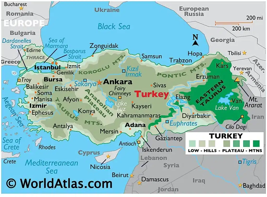
Q. Turkey is located between
(a) Black Sea and Caspian Sea
(b) Black Sea and Mediterranean Sea
(c) Gulf of Suez and Mediterranean Sea
(d) Gulf of Aqaba and Dead Sea
Answer: (b) Black Sea and Mediterranean Sea
Notes:
- Turkey, officially the Republic of Türkiye, is a transcontinental country located mainly on the Anatolian Peninsula in Western Asia, with a small portion on the Balkan Peninsula in Southeast Europe.
- Turkish peninsula is surrounded by four seas:- the Mediterranean to the south, the Aegean to the west, the Sea of Marmara between the European and Asian landmasses, and the Black Sea to the north.
- Turkey lies partly in Asia and partly in Europe.
- Capital – Ankara
- Currency – Turkish lira
- Most of the country’s citizens are ethnic Turks, while Kurds are the largest ethnic minority.
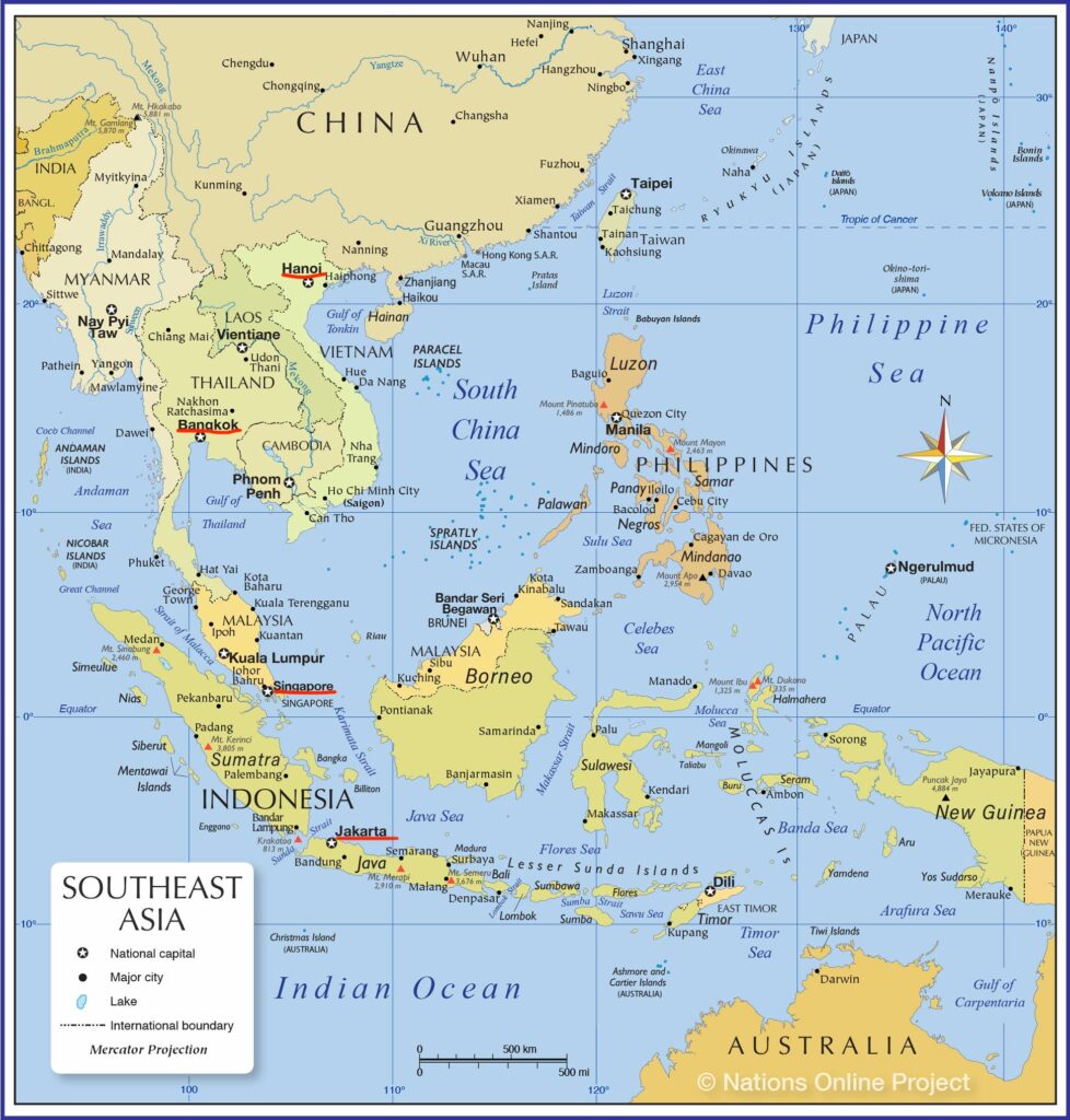
Q. What is the correct sequence of occurrence of the following cities in South-East Asia as one proceeds from south to north?
- Bangkok
- Hanoi
- Jakarta
- Singapore
Select the correct answer using the code given below.
(a) 4213
(b) 3241
(c) 3412
(d) 4321
Answer: (c) 3412
Notes:
- Jakarta-Singapore-Bangkok-Hanoi is the correct sequence of occurrence of the following cities in South-East Asia as one proceeds from south to north.
| Country | Capital | Currency | National Animal |
|---|---|---|---|
| Thailand | Bangkok | Thai Baht | Elephant |
| Vietnam | Hanoi | Vietnamese dong | Water Buffalo |
| Indonesia | Jakarta | Indonesian rupiah | Komodo dragon |
| Singapore | Singapore | Singapore dollar | Lion |
Q. With reference to ‘Changpa’ community of India, consider the following statement:
- They live mainly in the State of Uttarakhand.
- They rear the Pashmina goats that yield a fine wool.
- They are kept in the category of Scheduled Tribes.
Which of the statements given above is/are correct?
(a) 1 only
(b) 2 and 3 only
(c) 3 only
(d) 1, 2 and 3
Answer: (b) 2 and 3 only
Changpa community
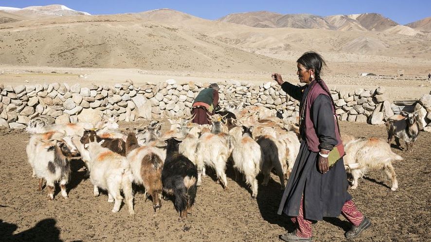
- The Changpa are a semi-nomadic Tibetan people found mainly in the Changtang in Ladakh and in Jammu and Kashmir.
- The Changpas rear the highly pedigreed and prized Changra goats (Capra Hircus) that yield the rare Pashmina (Cashmere) fibre.
- The pashmina fibre is the finest fibre of all goat hair.
- Due to the high altitude, the region is cold during summers with occasional snowfall and winters are extremely cold to work. Thus, maximum rearing is done during the summer season.
- In 1989, Changpas were declared as the Scheduled Tribes.
- The Changpa speak Changskhat, a dialect of Tibetan, and practice Tibetan Buddhism.
- Among the Changpa tribe, people are further divided into two other groups, namely, Phalpa and Fangpa.
Q. Consider the following towns of India:
- Bhadrachalam
- Chanderi
- Kancheepuram
- Karnal
Which of the above are famous for the production of traditional sarees/fabric?
(a) 1 and 2 only
(b) 2 and 3 only
(c) 1, 2 and 3
(d) 1, 3 and 4
Answer: (b) 2 and 3 only
Notes:
- Chanderi is a township in Ashoknagar district of Madhya Pradesh.
- The main occupation of the people of Chanderi is handicraft.
- Chanderi sarees are famous all over the world.
- Chanderi is also famous for Ancient Jain Temples.
- Kancheepuram in Tamil Nadu famous for silk Sarees.
- 108 holy temples of the Hindu god Vishnu, 15 are located in Kanchipuram.
- Bhadrachalam in Telangana is well-known as a pilgrimage destination.
- Bhadrachalam, located on the Godavari River, is a sacred pilgrimage site.
- This town is well-known for its Lord Rama temple.
- Karnal is famous for India’s tourist attractions due to its architectural prowess and cultural heritage.
- Karnal is home to several world-class institutes for research and development including the National Dairy Research Institute (NDRI), Directorate of Wheat Research (DWR), Central Soil Salinity Research Institute (CSSRI), National Bureau of Animal Genetic Resources (NBAGR) and Indian Agricultural Research Institute (IARI).
- Karnal has higher production of basmati, wheat, and other cereals, and the care for agriculture is more than in the other states in northern India.
