

Von Thunen’s Theory of Agricultural Location

Von Thunen conceived the idea of a land-use model in both urban and rural landscapes around a city set on an isotropic landscape. His central idea is how economic rent decreases from the centre of a city to its periphery.
His system of land use around a city with no trade alliance with any other country is ring-shaped. Near the city, he envisages rings of the forest, crop rotation, horticulture, and dairying. His theory stresses more on agricultural land use around a city rather than the land use within the city.
Ricardo gave the concept of Economic Rent, whereas Von Thunen gave the concept of Locational Rent — arguably his single greatest contribution to economic geography.
Historical Context The agricultural location theory is a normative economic model first presented by Johann Heinrich von Thunen, a Prussian landowner, in 1826 in a book called Der Isolierte Staat (Isolated State). Von Thunen used detailed data from his own agricultural estate at Macklenburg, near Rostock in Germany, which he operated and managed for forty years until his death. Most of the data used in explaining his theory was obtained through practical experience, including meticulous cost accounting of his estate.
This theory is based on the concept of Economic Rent, which is prevalent in farm-market distance relationships. The agricultural location theory is one of the earliest attempts to explain the pattern of land use in economic terms.
Von Thunen explains how crop productivity and land-use patterns change as one moves away from the market. The model applied mathematical and economic reasoning to geographic questions about land use, essentially founding the discipline of agricultural location theory.
Main Aims of the Von Thunen’s Theory of Agricultural Location
- To explain why and how agricultural land use pattern varies when we go away from the market.
- To explain the hierarchy of agricultural crops based on profit-making capacity.
- To show how transportation costs determine the optimal zone of cultivation for different crops.
- To introduce the concept of locational (economic) rent as a driver of spatial land-use decisions.
Key Terminology
| Term | Definition |
|---|---|
| Crop Productivity | Measured by the ratio of agricultural output to the input per unit agricultural area. |
| Intensive Farming | At least two or more crops grown per year on particular agricultural land. Large levels of inputs (money, fertilizer, labour) are used to get a high yield per unit area. |
| Extensive Farming | Less than two crops per year on a larger area with lower yield. Low level of inputs as compared to intensive farming. |
| Mixed Cropping | Growing two or more crops simultaneously on the same piece of land (e.g., wheat + gram). |
| Hinterland | An isolated region away from the coastline or river; the agricultural area surrounding the market city. |
| Isolated State | Completely flat land having equal soil fertility and climate with no river or mountain — the conceptual basis of the model. |
| Economic Rent (Ricardo) | Net income accruing to an area of land above the net income of land at the economic margin of production. |
| Locational Rent (Von Thunen) | Economic rent estimated by the location of agricultural land relative to the market. Increases as proximity to market increases (lower transport cost). |
| Isotropic Surface | A uniform plain with homogeneity in terrain, topography, and climatic conditions — a key model assumption. |
| Distance Decay | The principle that land rent declines away from the market point; the rate of decline varies by commodity. |
Basic Assumptions in the Von Thunen Model
- The isolated state comprises of one market area and an agricultural hinterland.
- The market receives goods only from the hinterland and the hinterland sells goods only to the market.
- The hinterland ships its surpluses to no other market except the city.
- There is a homogeneous physical environment, including a uniform Plain around the City.
- Farmers are settled in the hinterland who wish to maximize the profit.
- There is only one mode of transport that is horse wagon is used.
- Transportation cost is directly proportional to distance. The higher the distance higher the transport cost.
He had two basic postulates –
- The intensity of the production of particular crop declines with the distance from the Market. Here the intensity of production means the amount of inputs per unit area of the land.
- The type of land use will vary with distance from the Market.
Using these two principles and basic assumptions, the model tried to give the optimal land use pattern which will give farmers maximum profit or rent. Since a farmer is an economic person and hence they will farm those crops which will give more total profit or rent.
He observed that particular activities were focused in certain zones around the center, ideally this would then lead to a system of concentric rings with every ring specializing in different agricultural activities based on transportation costs, weight, and Perishability.
Von Thunen developed an agricultural location model with 2 prominent parts- Agricultural Land Use and Economic Rent.
Economic Rent
Few geographers later termed it as locational rent as well. This is the basic principle of Thunen’s analysis, where he argued that different types of land use produce different net returns per unit area. The price a farmer obtains can be calculated easily- the price at the market minus the cost of transporting it to the market.
Economic rent is the measure of the advantage of one piece of land over another. Since all farmers receive the same price at the market and production costs are also assumed to be the same, the only advantage one piece of land has over another is its location from the market. So, if it’s closer to the market, its locational rent is higher and it reduces with the distance from the market i.e.
LR= Y (m-c) – Ytd,
Where LR= locational rent per unit of land,
Y= yield per unit of land, m= market price per unit of land,
c= production cost per unit of product,
t= transport rate per unit of distance,
d= distance from the market.
| Symbol | Represents | Explanation |
|---|---|---|
| LR | Locational / Land Rent | Net profit per unit of land after subtracting transport costs from market revenue. |
| Y | Yield per unit of land | Volume of agricultural output produced per unit area. |
| m | Market price per unit | Price obtained at the central market for each unit of the commodity. |
| c | Production cost per unit | Cost incurred in producing each unit of the commodity. |
| t | Transport rate per unit/distance | Cost of transporting one unit of commodity per unit of distance. |
| d | Distance from market | Physical distance between the farm and the central market. |
Key Insight on Locational Rent: In this context, land rent differs from economic rent in that it takes no account of opportunity costs and so ignores what might be earned from alternative uses of the land. In the simplest applications of the model, transport costs are taken as the only variable (prices, production costs, and yields are held constant for each commodity). Rates per unit of distance vary, being highest for bulky and/or perishable items such as timber and dairy products. Thus, land rent declines away from the market point according to the ‘Distance Decay Model’, but the rate of decline differs by commodity.
Von Thunen’s Theory of Agricultural Location
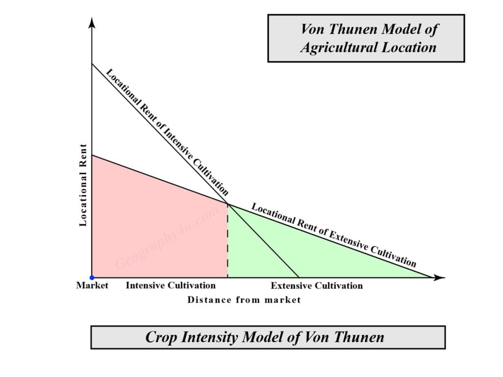
- Intensity Theory
- Crop theory
Intensity Theory
- Due to the rise in transportation cost, intensive cultivation is most suitable near the city centre.
- Therefore, the intensity of production of a particular crop declines with distance from the market.
- The greater the amount of money, labour, and fertilizers used, the greater the intensity of agricultural production — but this is only economically viable when transport costs are low, i.e., near the market.
Crop Theory
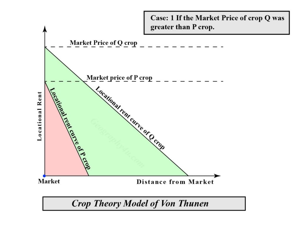
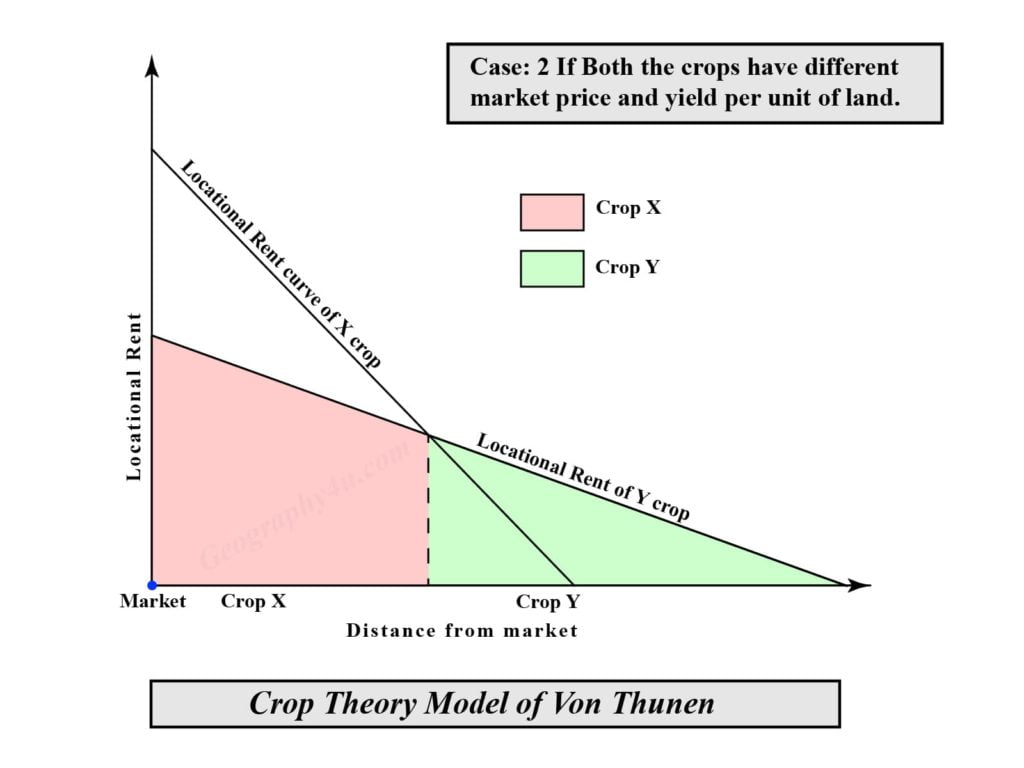
- According to crop theory, there will be a variation in the land use with distance and the factors responsible for the variation in the land use pattern are market price of a particular crop, transportation cost, production cost and yield per unit of land. The crop theory of Von Thunen can be understood by taking the following two cases.
- Case- 1: When two crops, P and Q, have the same production cost and yield but have different transport costs and market prices. If P is costlier to transport and has a higher market price, then crop P will be grown closer to the market than crop Q. Due to the higher transportation cost of crop P, the location rent of P decreases more rapidly.
- Example: Fresh milk vs. wheat. Milk is perishable and bulky (high transport cost), so it is grown immediately adjacent to the city.
- Case- 2: When two crops X and Y have the same production and transportation cost (per tonne/km) but different market price and yield per unit of land. If X has a higher yield and lower market price than Y, it will be grown closer to the market than Y.
- Example: Potatoes vs. wheat. Taking transport costs into account, potatoes are most profitably grown between 0 and point A, and wheat between A and B.
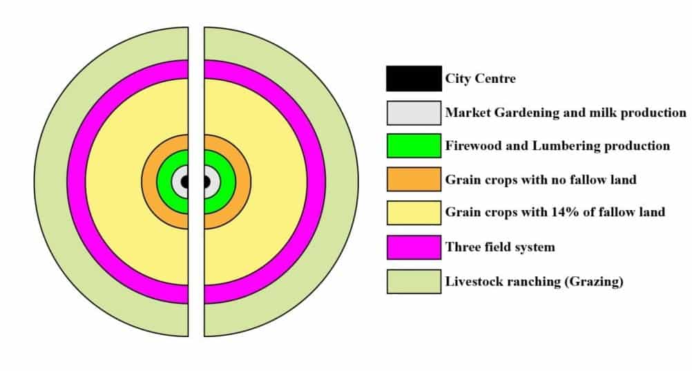
Concentric Zonal Rings of Agricultural Production
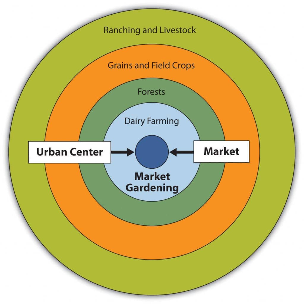
Von Thunen identified the following six concentric zonal rings of agricultural production around the central market city, ordered from innermost (nearest city) to outermost (farthest):
| Zone | Activity | Characteristics | Rationale |
|---|---|---|---|
| I | Market Gardening & Milk Production | Cash cropping; vegetables, fruits, flowers, fresh milk. Intensive cultivation; land fertility maintained by manuring. | Highly perishable products require immediate proximity to market. Primitive transport and absence of refrigeration make distance costly. |
| II | Firewood & Lumber Production | Production of fuelwood and timber. Bulky and heavy product. Yields higher locational rent due to high transport cost. | Wood was costly to ship because of its bulkiness. It was also in great demand in the city as fuel and building material in the early 19th century. |
| III | Grain Crops — No Fallow Land | Rye as primary crop; no fallow land. Highest cropping intensity among zones III–V. | Grain can be stored and transported easily, unlike dairy. Land is cheaper farther from market. No need to fallow to maximize output. |
| IV | Grain Crops — 14% Fallow Land | Seven-year crop rotation: rye, barley, oats, three-year pastures, one-year fallow (14% fallow). Products: rye, butter, cheese, live animals. | Land is less productive at this distance; reduced crop intensity is economically rational. Products (butter, cheese) are non-perishable enough for transport. |
| V | Three-Field System | 33% of land as fallow. Three-field system: 1/3 field crops (rye), 1/3 pastures, 1/3 fallow. Extensive cultivation. | Distance from market makes intensive farming unprofitable. Low inputs are sufficient as transport cost eats into margin. |
| VI | Livestock Ranching (Grazing) | Livestock farming (cattle). Products: butter, cheese, live animals (non-perishable by-products). | Animals can walk to market; by-products (cheese, butter) are compact and non-perishable, reducing transport cost per unit value. Rye does not produce sufficient rent at this distance. |
Why Forest (Zone II) Precedes Farmland?
- A frequently asked question is why forestry occupies Zone II, apparently displacing farming. Von Thunen’s answer lies in the relative transport cost: fuelwood is extremely bulky in relation to its value.
- At that time, wood was the primary source of energy and building material in European cities. Transporting it by horse-wagon was proportionally more expensive than transporting grain of equivalent market value.
- Hence, the economic rent curve for forest products falls steeply and remains dominant in Zone II before grain becomes more profitable in Zones III onward.
Modifications in the Von Thunen Model of Agricultural Location
- Von Thunen himself considered the potentially distorting effect of improved transportation routes as navigable waterways, roads, and railways on which transportation was speedier and costs only about one-tenth (along waterway) that of land transportation.
- As important cities generally have access to a navigable waterway, Thunen introduced a stream into his “Isolated State” resulting in the elongation of the production zone roughly along the stream.
- Zone-1 was least changed in shape; zone -2 extended in a narrow band for some distance in each direction from the city, but it was no longer an enclosed zone and instead of approaching close to the town it seems more likely that woodlands would have been situated at some distance up and down the stream.
- Since the transportation cost of wood was very high vis-a-vis its value; the river-side location was the most favoured location for this form of production.
- The provision of only “one market” was also subsequently removed by Von Thunen. The consideration of a minor market center with its own small tributary area apparently with the production of Zone-1 type opens up the possibility of numerous towns of roughly equal importance with intermingled production zones that modify each other. This leads towards the extreme complexity in the real world where the zonation around the individual cities is rudimentary or indistinguishable.
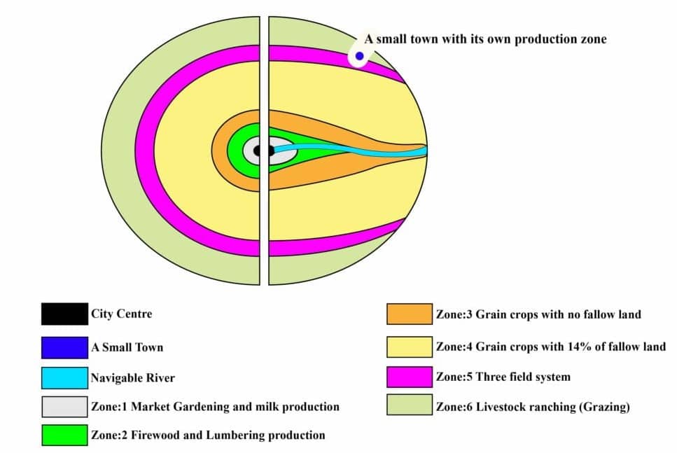
The following are the modification introduced in the classical model of Von Thunen.
- Introduction of a navigable river into his Isolated State.
- Elongation of production zones along the river.
- Extension of Zone-2 in a narrow band.
- Consideration of more than one market center or minor market centers.
- Possibility of numerous small towns of equal importance.
- Intermixing of production zones due to numerous towns.
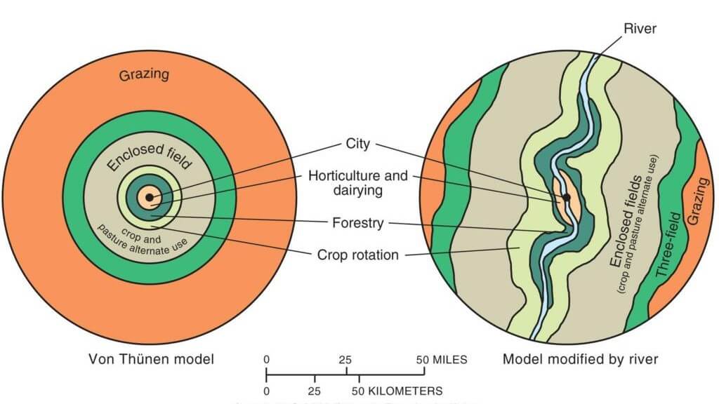
| Classical Model | Modified Model |
|---|---|
| Perfect concentric rings on an isotropic plain. | Elongated zones along navigable rivers and roads. |
| Single central market city. | Multiple market centres of varying importance. |
| Uniform transport cost in all directions. | Differential transport costs: waterway ~1/10th of land transport. |
| Zones clearly separated and non-overlapping. | Intermingled and overlapping production zones. |
Applications at Various Scales
1. Europe — Macro-Scale Application
A comparison of Von Thunen’s model with contemporary agricultural patterns was made by Samuel van Valkenburg and Colbert Held, whose map of Europe’s agricultural intensity reveals a striking ring-like concentricity. The overriding spatial change since Von Thunen’s time is the improvement in transportation technology, which permitted the isolated state to expand from micro to macro scale.
The model is no longer centred on a single city but on the vast urbanised area lining the southern coast of the North Sea, which now commands a continent-wide Thunen agricultural system.
| Country / Region | Agricultural Intensity Index | Von Thunen Zone Equivalent |
| Netherlands & Belgium | Highest (> 160) | Zone I equivalent — intensive farming close to North Sea market core |
| Denmark, N. Germany, France, UK | High (125–160) | Zone II–III equivalent — mixed intensive farming |
| Central Europe (Switzerland, Austria) | Moderate (100–125) | Zone III–IV equivalent |
| Eastern Europe | Below average (70–100) | Zone IV–V equivalent — less intensive cereal production |
| Mediterranean periphery | Low (< 70) | Zone V–VI equivalent — extensive farming and grazing |
Modern transportation and communication has modified the concentric agricultural zones of Von Thunen along roads and railways. The intensity of agriculture and yield per acre decrease going away from north-west Europe, broadly consistent with the model’s logic, although the periphery’s mountainous terrain (Alps, Pyrenees, Apennines) adds non-Thunian complexity.
2. United States — Macro-Scale Application
The US provides one of the most cited macro-scale applications of the Von Thunen model. The ‘supercity’ anchoring the macro-Thunian system is the north-eastern Megalopolis, which commands the country’s dominant food market and transport network.
| Agricultural Region | Location | Von Thunen Zone | Key Products |
| Atlantic Fruit & Vegetable Belt | Nearest to Megalopolis | Zone I | Fresh produce, dairy |
| Dairy Belt | Northeast / Great Lakes | Zone I–II | Milk, cheese, butter |
| Corn Belt | Midwest (Ohio to Nebraska) | Zone III | Meat, mixed crops, livestock feed |
| Winter/Spring Wheat Belts | Great Plains | Zone IV–V | Wheat grains (mass production) |
| Grazing & Ranching Region | Rocky Mountain West | Zone VI | Beef cattle, sheep |
Although the circular rings of the model are not apparent on the US agricultural map, many spatial regularities can be observed. The sequence of farming regions as distance from the national market increases — especially westward from Megalopolis towards central California — is consistent with the model’s logical structure, each zone successively farther inland along the main trans-continental route.
3. Relevance to Indian Conditions
In many underdeveloped and developing countries, including India, concentric patterns of land use can be observed around rural settlements in the Great Plains:
| Distance Zone | Typical Land Use (India) | Von Thunen Parallel |
| Innermost (village periphery) | Highly fertile, heavily manured land for perishable crops — vegetables, potatoes, orchards. | Zone I — Market gardening and dairy. |
| Middle belt | Cereal crops: rice, wheat, barley, maize, pulses, sugarcane. | Zones III–IV — Grain farming. |
| Fringe zone | Inferior cereals: bajra, guar, millets. | Zone V–VI — Extensive farming and grazing. |
Prof. M. Shafi tested the model in the Koil tehsil of Aligarh district (U.P.) and found that land-use intensity decreases away from intensively tubewell-irrigated areas. Prof. Jhujar Singh and Prof. Dhayan Kaur tested the model in different parts of Punjab and concluded that the model cannot be applied in its original form, as extension of irrigation facilities and a dense network of transport and communications have significantly affected cropping patterns and land-use intensity.
After the introduction of tubewell irrigation in the Great Plains of India, the concentric pattern of crop land use has been largely modified, as farmers with better economic status can produce perishable crops even in distant fields from the market and settlement. The diffusion of high-yielding varieties (HYVs) has made the application of this model almost irrelevant at both micro and meso levels. The model, thus, no longer operates in India in its original form — yet the fundamental gradient of land-use intensity with distance remains observationally relevant.
| Contemporary Indian Example: Perishable crops like vegetables and dairy cluster near metropolitan centres like Delhi and Mumbai, while cereals and pulses dominate distant rural regions. Modern factors like transportation infrastructure, refrigeration, and export markets modify the classical pattern, but the fundamental relationship between distance, transport costs, and crop selection continues shaping agricultural geography across Indian farming regions. In Kerala, the concentration of spice cultivation (cardamom, pepper) in the Western Ghats — close to trade routes — also aligns with Von Thunen’s principles of specialised production based on land suitability and market access. |
Critical Analysis: Limitations and Criticisms
The theory of agricultural location was presented by von Thunen in the early 19th century. Since then, several scholars including geographers have applied it in various parts of the world and have pointed out certain aspects that are not applicable in a way as pointed out by von Thunen.
Many aspects of this model have changed due to development in the agricultural systems, transportation system, and also due to other technological developments. There are also certain regional geo-economic factors that not only direct but determine the pattern of agricultural land use.
The main points raised by scholars regarding this theory are as follows:
- The conditions described in this model, i.e., in an isolated state, are hardly available in any region of the world. There are internal variations in climatic and soil conditions. Von Thunen’s assumptions that there are no spatial variations in soil types and climate are rare.
- It is not necessary that all types of farming systems as described by von Thunen in his theory exist in all the regions. In many European countries location of types of farming in relation to the market are no longer in existence.
- Thunen’s measures of economic rent and intensity are difficult to test because of their complexity. The measurement of the number of man-days worked in a year, the cost of labour per hectare, or the cost of total inputs per hectare is not uniform in intensive and extensive types of farming. Similar is the case with the measures of intensity,
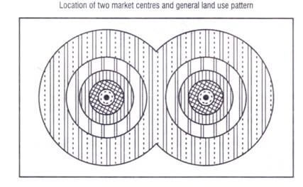
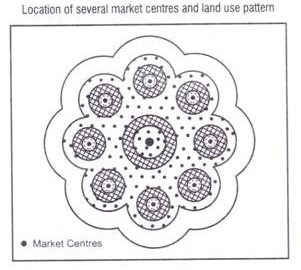
- Von Thunen himself has admitted that with the change in location of transportation or market center the pattern of land use will also change.
- The location of the transport link and its direction used to change the pattern of agricultural land use is depicted in Figure.
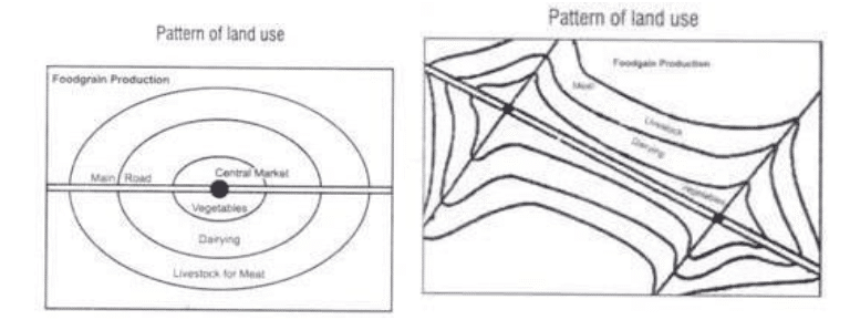
- Similarly, if there are two market centres, the pattern of land use will be according to Figure below
- The situation will be entirely different when there are several market centres in a region.
- During the past 190 years, there have been sizeable changes in agricultural land use and the economy with which it interacts. The most important of the changes have been improvements in transportation technology; these improvements now permit a space-time convergence of distant places, thereby expanding the scale of possible economic organization. In von Thunen’s day, heavily loaded horse-drawn carts moved to market at the rate of about 1 mile an hour.
- The von Thunen model is also static and deterministic. Today, we know that economic growth and changes in demand will alter the spatial patterns of agricultural systems and land use, which in turn influence the rate of change. It might be possible to postulate a dynamic von Thunen model that could be applied to the changing conditions.
Strengths and Enduring Value
Despite all these limitations, the validity of the model has been evaluated with considerable success at a range of spatial scales — from the global (Peet, 1969) to the individual village and farm holding (Blaike, 1971; Chisholm, 1979). The model also stimulated the modelling of zonal patterns of intra-urban land use in the same way (Alonso Model).
| Limitation | Enduring Relevance / Counterpoint |
|---|---|
| Assumes uniform terrain — unrealistic. | The core principle (distance = cost = land-use gradient) remains valid even when modified by terrain. |
| Does not account for refrigeration and modern logistics. | Principle of locating perishable and high-value crops closer to urban centres still holds broadly. |
| Ignores demand factors. | Model stimulated further research incorporating demand — e.g., Dunn (1954), Alonso (1964). |
| Static and non-dynamic. | Foundation for dynamic models of land-use change; still a useful benchmark against which contemporary patterns are measured. |
| Oversimplified farmer decision-making. | Inspired behavioural geography critiques (Wolpert, 1964) that enriched the field significantly. |
While criticising the model, it should be kept in mind that it was developed in 1826 when the means of transportation and communication were not so well developed and isolated estates were found in greater parts of the world. Von Thunen’s work is useful in two fundamental ways:
- It focuses attention on economic factors, particularly transport costs and distance to market, contrary to earlier geographers who were subordinated by physical environment factors.
- It introduced the concept of locational rent theory, which has great significance in both rural and urban land-use studies. Von Thunen’s assumptions led to more research in locational rent theories, crop intensity, and cropping patterns.
It can therefore be concluded that Von Thunen’s work, with all its limitations, still provides a useful framework for organising agricultural activities at the micro, meso, and macro levels.
Comparison with Related Theories
| Aspect | Von Thunen (1826) | Alfred Weber (1909) | Alonso Model (1964) |
| Focus | Agricultural land use | Industrial location | Urban land use (bid-rent) |
| Key Variable | Distance to market / transport cost | Least-cost location (transport + labour) | Willingness to pay (bid-rent curves) |
| Spatial Pattern | Concentric agricultural rings | Locational triangle | Concentric urban land-use rings |
| Concept of Rent | Locational/economic rent | Not central; focuses on cost minimization | Bid-rent curves by land user type |
| Scale | Rural / agricultural | Industrial / regional | Urban / intra-city |
| Limitation | Static, ignores demand | Ignores agglomeration dynamics | Assumes homogeneous urban space |
Modern Relevance and Future Directions
Factors That Have Modified the Model’s Applicability
- Refrigeration and cold-chain logistics: perishable commodities can now be transported over thousands of kilometres.
- Air freight and modern infrastructure: overcome proximity limitations entirely for high-value products.
- Urbanisation and multiple markets: warp concentric zones through complex market interactions.
- Government intervention and subsidies: alter land-use goals independent of market logic.
- Non-economic farmer behaviour: habit, risk-aversion, and cultural factors diverge from profit-maximising rationality.
- Globalisation: global agricultural trade exceeded $1.6 trillion in 2022, highlighting the role of international markets over local distance-cost gradients.
- High-Yielding Varieties (HYVs) and Green Revolution: enabled intensive production far from markets.
- Tubewell irrigation (India): allowed perishable crop production in distant fields.
Remaining Relevance
Despite its limitations, Von Thunen’s model retains considerable relevance:
- Proximity to Markets: the principle of locating perishable and high-value crops closer to urban centres remains broadly valid.
- In Brazil: land use near marketplaces prioritising meat production still leads to more intense land use, consistent with the model.
- In agribusiness: firms strategically locate processing plants and distribution centres to optimise distance and transport efficiency — a direct application of Von Thunen’s logic at the corporate scale.
- The model remains referenced in regional planning, agricultural policy, and economic geography studies worldwide.
- It introduced iso-rent lines based on land value and productivity, which continue to inform urban and rural planning theory.
Future Research Opportunities
- Addressing the dynamics of land-use changes over time — developing a truly dynamic Von Thunen model.
- Enhancing understanding of surplus measurements in contemporary market conditions.
- Incorporating risk aversion into agricultural models to reflect real-world farming practices.
- Integrating modern factors (refrigeration, digital markets, precision agriculture) into modified versions of the model.
- Applying the model in conjunction with GIS and spatial econometrics for empirical testing at regional scales.
Summary Snapshot
| Category | Details |
|---|---|
| Author | Johann Heinrich von Thunen (1783–1850), Prussian landowner and agricultural economist. |
| Published | 1826 in Der Isolierte Staat (The Isolated State). |
| Data Source | 40 years of detailed cost accounting from his own estate at Macklenburg, near Rostock, Germany. |
| Core Concept | Locational Rent — economic rent determined by location relative to market (distance and transport cost). |
| Key Formula | LR = Y(m – c) – Ytd (Locational Rent = Yield × [Market Price – Production Cost] – Yield × Transport Rate × Distance). |
| Model Output | Six concentric agricultural zones: (I) Market Gardening & Dairy, (II) Forestry, (III) Grain/No Fallow, (IV) Grain/14% Fallow, (V) Three-Field System, (VI) Livestock Ranching. |
| Modifications | Navigable river elongates zones; multiple market centres create intermingled zones. |
| Significance | Pioneer of agricultural location theory; foundation for locational rent, crop intensity, and urban bid-rent models (Alonso). |
| Major Criticism | Based on unrealistic assumptions; static and deterministic; ignores demand, technology, and environmental factors. |
| Contemporary Value | Broadly applicable at macro scale (Europe, US); useful framework for rural land-use analysis, regional planning, and agribusiness strategy. |







Sir, thank a lot for providing notes on this topic. I visited many websites but did not get satisfactory answer. This article has just cleared my all doubt .
Thanks, Rajan for your graceful feedback.
thank you sir for making learning easy
Most welcome Arjun
Wonderful theory
Could you kindly provide details regarding the applicability of Von Thunen’s model in the Indian context? Thanks in advance
You can find it in the book ‘Human geography’ by Majid Hussain. page no.356
check Pangeography.com
thank you annayya…
Updated!
Sir, your compilation has helped me a lot in clearing my doubts. This will also enable me for getting a good marks in mains. I thank you for your hard work and selfless service.
Most welcome, Keep reading.
this compilatons are nourishing to achieve the ultimate goal of this journey of any aspirants. i have no words to thank you .
just wow ! very crispy & point wise….Thanks a lot sir for helping.
thankyou sir , it will be more helpful if possible for you to include case studies
According to von theory Exaplaintion on farmers, harder/ are persistence
Thank you,sir.
It was really helpful.
Thank you so much .Really helpful
I find this material very concise yet complete in information on the topic. I’d like to use it as one of the references in my upcoming oral presentation and give due credit to the source. Thank you for making my studies easier.
Thank you for helping me so much 😊😊
ONE OF THE FINEST WEBSITE FOR ALL CIVIL SERVICE ASPIRANTS..THANKS A LOT SIR…
Thank you Sir
Very nice please for the off format
Thank you sir for giving me the relivent details
Thank you sir for giving me all details
Now i got the perfect compilation to boost in my optional!
A heartly Thank you, sir!
Thanks Sir 😃
How it is relevance in present context?
Really sir very fruitful 🍓
I understand This Theory,, Thank you.
Thank’s a lot sir, tomorrow is my exam but this concept is clear,some how I can get passing mark…
Best in the internet
The best content for quick revision there is! Thanks a lot, Kudos to the LotusArise team.
Thankyou for the detailed notes.