

- A glacier is a mass of ice that forms from compacted snow and moves under its own weight. Glaciers are classified above all by size and setting: what they cover, what confines them, and where they end.
- Other ways of sorting them are by thermal regime, by the season when they gain snow, and by the debris on their surface. The last two matter most for India.
- India has no ice sheet or ice cap. Its ice is almost wholly mountain ice in the Himalaya and Karakoram, mainly valley glaciers. The important glaciers of India shape the high valleys through glacial erosion and distinctive landforms.
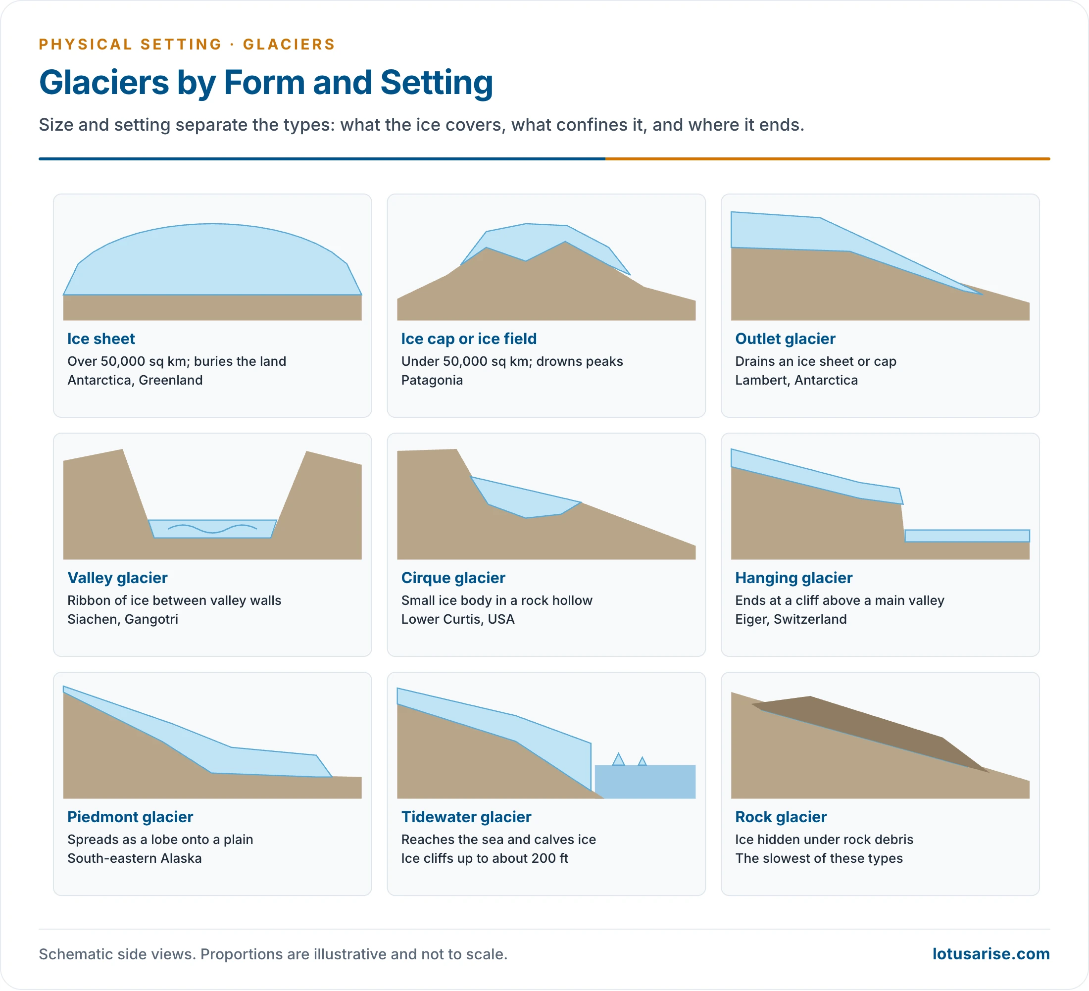
Types by Form and Setting
Continental Glaciers
- Continental glaciers or continental ice sheets are the largest glaciers on the planet.
- They are sometimes also called ice caps, but in strict use ice sheet applies above 50,000 sq km and ice cap below it.
- About 99% of the glacial ice on earth lies in ice sheets.
- The Antarctic and Greenland ice sheets are the two that exist today. Each covers more than 50,000 sq km, which is the threshold and far below their real extent, of millions of square kilometres.
- Not bounded by mountains or similar landforms, they spread out in all directions and cover everything in their path.
- As ice sheets fan out from the centre, whole valleys, plains and even mountain ranges lie buried.
Ice Caps and Ice Fields
- An ice cap or ice field covers less than 50,000 sq km.
- It can still completely cover peaks in mountainous areas, as in the ice fields of Patagonia.
- These large bodies of ice feed many other types of glacier, which spread out from their centre.
Outlet Glaciers
- Glaciers that flow out of ice sheets, ice fields or ice caps are outlet glaciers.
- The landscape controls their flow, through valleys and past exposed rock, in the same way as with valley glaciers.
- An outlet glacier often continues through these rocky channels to become a valley glacier. Lambert Glacier in Antarctica is an example.
- They can include other types, such as valley and piedmont glaciers.
- Sea level: with global warming, a significant share of sea-level rise is believed to come from the melting of outlet glaciers in Greenland.
Valley Glaciers
- Flowing streams of ice confined within steep valley walls. They are easy to identify by their long, narrow, ribbon-like form.
- They can form when an outlet glacier slides away from an ice field. Most, however, begin as mountain glaciers and stretch towards gorges, basins and valleys.
- Indian examples are the standard type of the Himalaya: Siachen (about 76 km) in the Nubra valley and Gangotri (about 30 km), the source of the Ganga.
Hanging Glaciers
- It begins high in the mountains and feeds into a valley glacier.
- Unlike the smooth meeting of a river with its tributary, a hanging glacier towers over the edge of a cliff like a frozen waterfall.
- Its defining mark is that it ends abruptly.
- Examples: Tronador or “thunder” glacier in northern Patagonia, named for the sound of ice crashing into the bowl-shaped valley below, and the Eiger Glacier in Switzerland.
Cirque Glaciers
- Perhaps the smallest type of glacier, found in the bowl-shaped hollows called cirques, which give them their name.
- Cirques form in mountain ranges where fallen snow settles quickly into the surrounding ground.
- Examples: the Lower Curtis and Eel glaciers in the United States.
Piedmont Glaciers
- A subtype of valley glacier, found where a narrow mountain valley opens onto a wide plain or a larger, deeper valley.
- A mass of ice flows downslope to low ground and fans out in broad lobes of solid ice.
- The largest piedmont glacier in the world is in south-eastern Alaska.
Rock Glaciers
- All glaciers carry rock and debris gathered as ice flows over bedrock. Rock glaciers are different: the ice is mostly hidden beneath rock debris.
- At first sight one may not look like a glacier at all, but like a muddy landslide.
- They are probably the slowest-moving of all these types.
Tidewater Glaciers
- A tidewater glacier is a river of ice that reaches the coast.
- Its leading edge lifts slightly and floats in the ocean, forming ice cliffs up to about 200 feet high.
- They are known for calving: pieces of ice break away and crash into the water with a loud noise, raising strong waves.
Glaciers in the Indian Setting
How Much Ice and Where
- The Himalaya is the “abode of snow”. Of nearly five lakh sq km of mountains, classical estimates put about 33,000 sq km under snow, with about 15,000 glaciers between the two syntaxial bends.
- The Geological Survey of India count for India is 9,575 glaciers over about 37,465 sq km.
| State | Glaciers | Area (sq km) | Average size (sq km) |
|---|---|---|---|
| Jammu and Kashmir, Ladakh | 5,262 | 29,163 | 10.24 |
| Himachal Pradesh | 2,735 | 4,516 | 3.35 |
| Uttarakhand | 968 | 2,857 | 3.87 |
| Sikkim | 449 | 706 | 1.50 |
| Arunachal Pradesh | 162 | 223 | 1.40 |
- The western ranges hold the big ice. Size and area fall steadily to the east.
- Regional groups along the arc:
- Karakoram: the greatest development, with about 16,000 sq km of ice, about half the snow-bound area in the classical estimate. Siachen, Hispar, Biafo, Baltoro, Batura and Chogo Lungma are here.
- Pir Panjal: fewer and smaller, as with Sonapani (15 km) and Bara Shigri in the Chandra valley.
- Kumaon–Garhwal: Gangotri (30 km) and Milam (20 km).
- Nepal, Kanchenjunga–Everest: Rongbuk (52 km) on the north side of Everest, Khumbu (20 km), Zemu (25 km).
The Snowline Varies
- The snowline, the lowest level of perpetual snow, depends on latitude, precipitation and local relief.
- Glaciers descend to different heights: about 3,965 m around Kanchenjunga, about 3,660 m in Kumaon and Lahaul, and as low as about 2,500 m in Kashmir. Chogo Lungma reaches 2,075 m, the lowest recorded.
- T. D. La Touche explained part of this by the rise in latitude, from 28°N at Kanchenjunga to 36°N in the Karakoram, and part by the abrupt rise of the eastern Himalaya.
- In the west, total precipitation is lower, but all of it falls as snow.
- In the Great Himalaya the snowline is lower on the steeper, wetter southern slopes.
Variation in the Nature of Indian Glaciers
| Basis | Western side | Eastern side |
|---|---|---|
| Season of accumulation | Winter-accumulation type, fed by the westerlies (Karakoram, Pamir) | Summer-accumulation type, fed by the monsoon (Nepal, Bhutan) |
| Size | Large (Karakoram, average over 10 sq km in J&K) | Small (under 2 sq km in Sikkim and Arunachal) |
| Sensitivity to warming | Lower | Higher: rain replaces snow in the melt season |
| Recent behaviour | Karakoram balanced or slightly gaining | Retreating |
- Himachal Pradesh and Jammu and Kashmir are a transition zone, between monsoon and westerly influence.
- Debris cover changes how a glacier responds. A thick mantle protects ice, and so debris-covered glaciers can persist at low levels. Chorabari in Uttarakhand is 53% debris-covered against 6% at Dokriani, and it retreats far more slowly: 6.9 m against 17.2 m a year.
- Surge-type glaciers advance fast for short spells. They are widespread in the Karakoram and rare elsewhere in High Mountain Asia.
- The Karakoram Anomaly: for two decades, Karakoram glaciers have shown balanced or slightly positive budgets, while most of the region retreats. It is not expected to last under continued warming.
Past Ice in India
- India’s rocks record three ice ages: Dharwar, Gondwana (Talchir) and Pleistocene, each tied to a part of the Indian rock system.
- Old moraines and glaciated valleys show that Pleistocene ice reached well beyond today’s limits.
Emerging Issues under Climate Change
- Faster melt: glaciers of the Hindu Kush Himalaya lost ice 65% faster in 2011–2020 than in the previous decade.
- Future loss: they could lose up to 80% of their volume by 2100 on current emission paths.
- Water: availability from melt is expected to peak by mid-century, then decline.
- Glacial lake outburst floods: the South Lhonak lake in Sikkim burst on the night of 3–4 October 2023. It destroyed the Teesta III project at Chungthang, 63 km downstream, and the event took 102 lives on one regional count.
- More exposure: the risk grows as roads, dams and towns move higher into the mountains.





Awesome. Thanks a lot for this beautified content .