Q. Consider the following pairs:
Region often mentioned in the news: Country
- Anatolia Turkey
- Amhara Ethiopia
- Cabo Delgado Spain
- Catalonia Italy
How many pairs given above are correctly matched?
(a) Only one pair
(b) Only two pairs
(c) Only three pairs
(d) All four pairs
Answer: (b) Only two pairs
Anatolia
- Anatolia is a large peninsula in Western Asia and covers a major part of Turkey.
- Anatolia can be defined in geographic terms as the area bounded to the north by the Black Sea, to the east and south by the Southeastern Taurus Mountains and the Mediterranean Sea, and to the west by the Aegean Sea and Sea of Marmara.
- culturally the area also includes the islands of the eastern Aegean Sea.
- In most prehistoric periods the regions to the south and west of Anatolia were under the influence of, respectively, Syria and the Balkans.
Amhara
- The Amhara Region officially the Amhara National Regional State is a regional state in northern Ethiopia and the homeland of the Amhara people.
- The Amhara are one of the two largest ethnolinguistic groups in Ethiopia.
- They constitute more than one-fourth of the country’s population.
- The Amharic language is an Afro-Asiatic language belonging to the Southwest Semitic group.
Cabo Delgado
- Cabo Delgado is the northernmost province of Mozambique.
- It has an area of 82,625 square kilometers and a population of 2,320,261.
- As well as bordering Mtwara Region in the neighboring country of Tanzania, it borders the provinces of Nampula and Niassa.
Catalonia
- The Catalonia region, in northeastern Spain.
- is known for the lively beach resorts of Costa Brava as well as the Pyrenees Mountains.
- Languages spoken here are the Catalan language and Spanish Language.
Must Read: Historical Region and Disputed Regions
Q. Which one of the lakes of West Africa has become dry and turned into a desert?
(a) Lake Victoria
(b) Lake Faguibine
(c) Lake Oguta
(d) Lake Volta
Answer: (b) Lake Faguibine
Lake Faguibine
- It is an isolated lake in Mali, west of Timbuktu (Tombouctou).
- It lies north of the Niger River in the Macina depression, and it is reached by branches of Niger in times of flood.
- At high water, it reaches a length of about 50 miles (80 km).
- One example of increasing aridity in Mali appears in Lake Faguibine.
- These false-colour Landsat satellite images of the lake show how it changed over the decades.
- Lake Faguibine has experienced widely fluctuating water levels since the turn of the twentieth century but, at its fullest, has ranked among the largest lakes in West Africa.
- In 1974, this lake covered roughly 590 square kilometres (230 square miles).
- Starting in the late 1980s, a drop in precipitation steadily dried the lake.
- By the late 1990s, the traditional livelihoods of fishing, agriculture, and livestock herding became impractical. Even though normal rainfall resumed after the year 2000, the lake remained nearly dry.
Lake Victoria
- It is located at the border of Uganda, Kenya, and Tanzania on the African continent.
- River Nile originates from Lake Victoria and drains into the Mediterranean sea.
- Victoria Lake is the largest tropical lake in the world and one of the largest freshwater lakes in the world by area.
- Its area is 26,828 square miles (69,484 square km).
- Among the freshwater lakes of the world, it is only behind the Lake Superior of North America.
- Its waters fill a shallow depression in the centre of the great plateau that stretches between the Western and Eastern Rift Valleys.
Oguta Lake
- It is a lean ‘finger lake’ formed by the damming of the lower Njaba River with alluvium.
- It is the largest natural lake in Imo State, Southeastern Nigeria; within the equatorial rainforest region of Niger Delta.
Lake Volta
- It is the largest artificial reservoir in the world based on the surface area, is contained behind the Akosombo Dam which generates a substantial amount of Ghana’s electricity.
- It is completely within the country of Ghana and has a surface area of 8,502 square kilometres.
Must Read: Important Lakes of the World
Q. Gandikota canyon of South India was created by which one of the following rivers ?
(a) Cauvery
(b) Manjira
(c) Pennar
(d) Tungabhadra
Answer: (c) Pennar
Gandikota
- The almost forgotten gorge of Gandikota is situated on the Pennar River in Andhra Pradesh and is known as the Grand Canyon of India.
- A gorge is any valley formed by a source of water flowing between tall slabs of steep rocks.
- Gorges are formed as a result of erosion of rocks over a long period of time.
- India has always been a popular tourist destination for its historic forts, stunning palaces and dense jungles.
- Now, a lesser-known gorge in the southern state of Andhra Pradesh is drawing visitors.
- The gorge is a stunning maze of jagged rocks layered in shades of red.
- The Penna river meanders through the canyon floor as it cuts through the Erramala hills.
- The area is now known as the Grand Canyon of India because of its resemblance to the famous US landmark.
- It’s also home to two ancient temples and a 12th Century fort that sits atop the hills surrounding the gorge.
- Pennar River
- Pennar rises on the Nandi Hills in the Chikkaballapur district of Karnataka, passing north to east through Karnataka and Andhra Pradesh.
- The Penna rises in the Chenna Kesava hill of the Nandidurg range, in the Chikkaballapura district of Karnataka, and flows towards the east eventually draining into the Bay of Bengal.
- The total length of the river from its origin to its outfall in the Bay of Bengal is 597 km.
- Located in peninsular India, the Pennar basin extends over the states of Andhra Pradesh and Karnataka having an area of 55 thousand Sq.km.
Also Read: Canyons, Gorges and Valleys of India
Q. Consider the following pairs:
Peak Mountains
- Namcha Barwa Garhwal Himalaya
- Nanda Devi Kumaon Himalaya
- Nokrek Sikkim Himalaya
Which of the pairs given above is/are correctly matched?
(a) 1 and 2
(b) 2 only
(c) 1 and 3
(d) 3 only
Answer: (b) 2 only
Namcha Barwa
- Namcha Barwa is in North-Eastern India whereas Garhwal Himalaya is in Uttarakhand.
- It is in an isolated part of southeastern Tibet rarely visited by outsiders.
- It stands inside the Great Bend of the Yarlung Tsangpo River as the river enters its notable gorge across the Himalayas, emerging as the Siang and becoming the Brahmaputra.
- On other hand, the Garhwal Himalayas are mountain ranges located in the Indian state of Uttarakhand.
Nanda Devi
- Kumaun Himalayas, the west-central section of the Himalayas in northern India, extends 200 miles (320 km) from the Sutlej River east to the Kali River.
- The range, comprising part of the Siwalik Range in the south and part of the Great Himalayas in the north, lies largely within the state of Uttarakhand, northwest of Nepal.
- It rises to 25,646 feet (7,817 metres) at Nanda Devi, the range’s highest peak.
Nokrek
- The Nokrek Biosphere Reserve is located in the northeast of India on the Tura Range, which forms part of the Meghalaya Plateau (average altitude: 600 meters).
Must Read: Mountain Peaks in India
Q. The term “Levant” often heard in the news roughly corresponds to which of the following regions?
(a) Region along the eastern Mediterranean shores
(b) Region along North African shores stretching from Egypt to Morocco
(c) Region along Persian Gulf and Horn of Africa
(d) The entire coastal Mediterranean Sea of areas
Answer: (a) Region along the eastern Mediterranean shores
Levant
- It is an approximate historical geographical term referring to a large area in the Eastern Mediterranean region of Western Asia.
- In its narrowest sense, which is in use today in archaeology and other cultural contexts, it is equivalent to a stretch of land bordering the Mediterranean in southwestern Asia, i.e. the historical region of Syria (“greater Syria”), which includes present-day Syria, Lebanon, Jordan, Israel, Palestine and most of Turkey southwest of the middle Euphrates.
- Its overwhelming characteristic is that it represents the land bridge between Africa and Eurasia.
- The Levant has been described as the crossroads of western Asia, the eastern Mediterranean and northeast Africa.
- The name Levant States was given to the French mandate of Syria and Lebanon after World War I, and the term is sometimes still used for those two countries, which became independent in 1946. A similar term, Al-Mashriq (“Where the Sun Rises”), exists in Arabic, although this term refers to a broader geographic region.

Q. Consider the following countries:
- Azerbaijan
- Kyrgyzstan
- Tajikistan
- Uzbekistan
- Turkmenistan
Which of the above have borders with Afghanistan?
(a) 1, 2 and 5 only
(b) 1, 2, 3 and 4 only
(c) 3, 4 and 5 only
(d) 1, 2, 3, 4 and 5
Answer: (c) 3, 4 and 5 only
Afghanistan
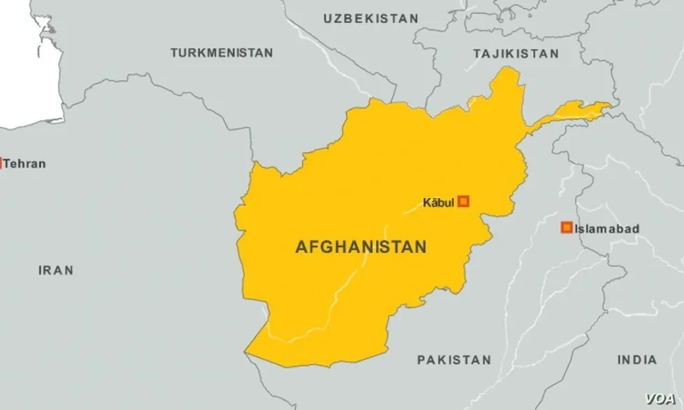
- Afghanistan, officially the Islamic Republic of Afghanistan, is a mountainous landlocked country in southern Central Asia.
- It borders Tajikistan, Turkmenistan, and Uzbekistan to the north, Iran to the west, Pakistan to the east and south.
Q. With reference to India, consider the following statements:
- Monazite is a source of rare earths.
- Monazite contains thorium.
- Monazite occurs naturally in the entire Indian coastal sands in India.
- In India, Government bodies only can process or export monazite.
Which of the statements given above are correct?
(a) 1, 2 and 3 only
(b) 1, 2 and 4 only
(c) 3 and 4 only
(d) 1, 2, 3 and 4
Answer: (b) 1, 2 and 4 only
Monazite
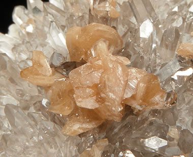
- It is one of the beach sand minerals that contain rare earth-like, lanthanum, cerium, praseodymium, neodymium etc.
- Monazite is a reddish-brown phosphate mineral containing rare earth metals.
- It also contains thorium which is a “prescribed substance”, the list of which was revised in 2006 under the Atomic Energy Act, 1962.
- Monazite does not occur naturally in the entire Indian coastal sands in India.
- Monazite is an atomic mineral that occurs naturally in the coastal sands of three districts: Tirunelveli, Thoothukudi, and Kanyakumari.
- Indian Rare Earths Limited (IREL), a wholly-owned Public Sector Undertaking of the Government of India (GOI) under DAE, is the only entity that has been permitted to produce and process monazite and handle it for domestic use as well as for export.
- It is a radioactive atomic mineral used for the production of Thorium (as high as 500 ppm) and has the potential to be used as fuel in the nuclear power system.
Q. In the northern hemisphere, the longest day of the year normally occurs in the:
(a) First half of the month of June
(b) Second half of the month of June
(c) First half of the month of July
(d) Second half of the month of July
Answer: (b) Second half of the month of June
Summer solstice
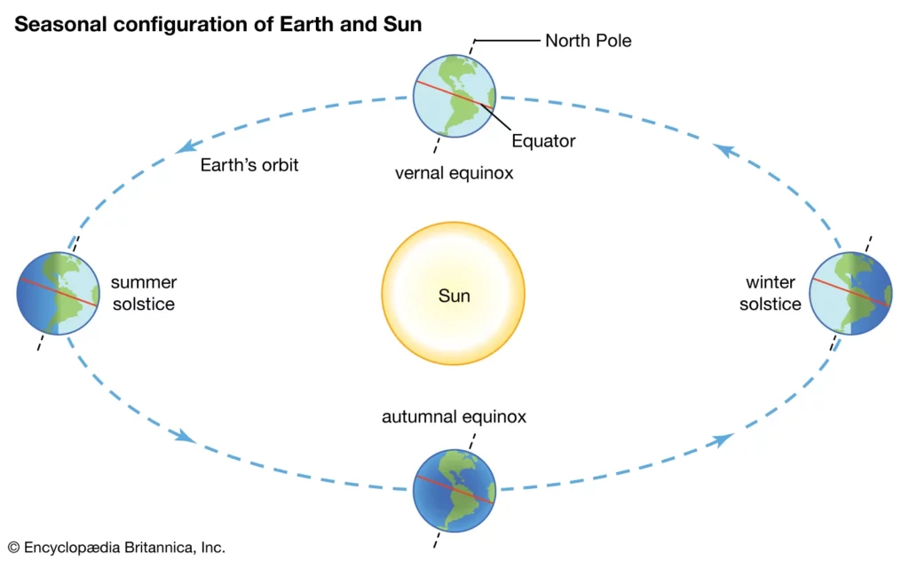
- The longest day of 2021 for those living north of the Equator is June 21. Hence, In the northern hemisphere, the longest day of the year normally occurs in the Second half of the month of June.
- In technical terms, this day is referred to as the summer solstice, the longest day of the summer season.
- It occurs when the sun is directly over the Tropic of Cancer, or more specifically right over 23.5 degrees north latitude.
- During the solstice, the Earth’s axis around which the planet spins, completing one turn each day is tilted in a way that the North Pole is tipped towards the sun and the South Pole is away from it.
- This day is characterised by a greater amount of energy received from the sun.
- According to NASA, the amount of incoming energy the Earth received from the sun on this day is 30 per cent higher at the North Pole than at the Equator.
- The maximum amount of sunlight received by the Northern Hemisphere during this time is usually on June 20, 21 or 22.
- In contrast, the Southern Hemisphere receives most sunlight on December 21, 22 or 23 when the northern hemisphere has its longest nights or the winter solstice.
Q. Consider the following States:
- Andhra Pradesh
- Kerala
- Himachal Pradesh
- Tripura
How many of the above are generally known as tea-producing States?
(a) Only one State
(b) Only two States
(c) Only three States
(d) All four States
Answer: (c) Only three States
Tea Production in India
- Tea is one of the world’s most popular and lowest-cost beverages and is consumed by many people.
- Owing to its increasing demand, tea is considered to be one of the major components of the world beverage market
- Indian tea is among the finest in the world owing to strong geographical indications, heavy investment in tea processing units, continuous innovation, augmented product mix, and strategic market expansion.
- Assam is the largest producer of tea in india.
- Assam produces almost half of the total tea made in India. The tea-producing region lies on either side of the Brahmaputra River.
The major tea-producing states in India are
- Major tea-producing states are Assam, the hills of Darjeeling and Jalpaiguri districts, West Bengal, Tamil Nadu, and Kerala.
- Apart from these, Himachal Pradesh, Uttarakhand, Meghalaya, and Tripura are also tea-producing states in the country.
Climatic Conditions for tea production
- The tropical and subtropical climate is required for tea production.
- Deep and fertile well-drained soil, rich in humus and organic matter.
- The warm and moist frost-free climate throughout the year.
- The rainfall should be 1500mm.
- The temperature should be less than 15 degrees Celsius.
Q. Consider the following pairs:
Reservoirs : States
- Ghataprabha : Telangana
- Gandhi Sagar : Madhya Pradesh
- Indira Sagar : Andhra Pradesh
- Maithon : Chhattisgarh
How many pairs given above are not correctly matched?
(a) Only one pair
(b) Only two pairs PAY
(c) Only three pairs
(d) All four pairs
Answer: (c) Only three pairs
Ghataprabha
- The Ghataprabha Reservoir is located in the Belgavi district of Karnataka.
- Ghataprabha has a hydroelectric and irrigational dam at Hidkal.
- Hidkal Dam is located in the Belagavi district of Karnataka. This dam was completed in the year 1977. A reservoir was also built on the dam to make it a multipurpose project.
- The reservoir has storage of about 659 million cubic meters, providing irrigation to a total extent of 1,396,000 hectares of land.
- Ghataprabha River
- The Ghataprabha river is an important right-bank tributary of the Krishna River and flows eastward for a distance of 283 kilometers before its confluence with the Krishna River at Chikksangam. The river basin is 8,829 square kilometers wide and stretches across Maharashtra and Karnataka states.
- The Markandeya and Hiranyakeshi rivers are tributaries of the Ghataprabha.
- Gokak Falls – on River Ghataprabha
Gandhi Sagar
- Gandhisagar is one of four major dams built on India’s Chambal river. This dam is located in Mansour, Neemuch district of the state of Madhya Pradesh.
- Gandhi Sagar Dam on the Chambal River (Madhya Pradesh) is one of the five reservoirs of national importance.
- The Foundation stone of the construction of the Gandhinagar dam in the district was laid by prime minister pandit Jawaharlal Nehru on 7 March 1954.
- Rana Pratap Sagar Dam
- The Rana Pratap Sagar Dam is a gravity masonry dam of 53.8 metres (177 ft) height built on the Chambal River at Rawatbhata in Rajasthan. It is part of integrated scheme of a cascade development of the river involving four projects starting with the Gandhi Sagar Dam in the upstream reach (48 kilometres (30 mi) upstream) in Madhya Pradesh and the Jawahar Sagar Dam on the downstream (28 kilometres (17 mi) downstream) with a terminal structure of the Kota Barrage (28 kilometres (17 mi) further downstream) in Rajasthan for irrigation.
Indira Sagar
- Indira Sagar Dam is a multipurpose dam project in Madhya Pradesh.
- It was built on the Narmada river which flows from Central India to Western India.
- The downstream projects of Indira Sagar Project (ISP) are Omkareshwar, Maheshwar, and Sardar Sarovar Project.
- River Narmada, the fifth largest river in India, with a river flow length of 1,312 km, originates from Amarkantak in Anuppur district of Madhya Pradesh. Narmada flows southwestward and after passing through Madhya Pradesh, Gujarat, and a small stretch in Maharashtra, it drains into the Arabian Sea near the Gulf of Khambhat.
Maithon Dam
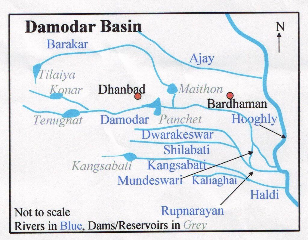
- The Maithon Dam is located at Maithon in Jharkhand.
- Maithon Dam is located on the bank of the river Barakar.
- It is owned by the Damodar Valley Corporation.
- Damodar Valley Project on river Damodar in Jharkhand. Maithon dam was specially designed for flood control and generates 60,000 kW of electric power.
- Barakar River
- The Barakar River is the main tributary of the Damodar River in eastern India.
- Originating near Padma in Hazaribagh district of Jharkhand it flows for 225 kilometres (140 mi) across the northern part of the Chota Nagpur Plateau, mostly in a west to east direction, before joining the Damodar near Dishergarh in Asansol, Bardhaman district of West Bengal.
- Tilaiya Dam:
- Damodar Valley Corporation DVC’s first dam, Tilaiya Dam, was across the Barakar at Tilaiya, in Hazaribagh district of Jharkhand, now in Koderma district of Jharkhand.
- Tilaiya hydel power station is located on the left bank of the river Barakar.
Q. With reference to the “Tea Board” in India, consider the following statements:
- The Tea Board is a statutory body.
- It is a regulatory body attached to the Ministry of Agriculture and Farmers Welfare.
- The Tea Board’s Head Office is situated in Bengaluru.
- The Board has overseas offices at Dubai and Moscow.
Which of the statements given above are correct?
(a) 1 and 3
(b) 2 and 4
(c) 3 and 4
(d) 1 and 4
Answer: (d) 1 and 4
Tea Board
- The origin of the Tea Board can be traced to 1903 when the Indian Tea Cess Bill was passed to provide for levying a cess on tea exports.
- The Tea Board is set up under the Tea Act 1953. It has succeeded the Central Tea Board and the Indian Tea Licencing Committee which functioned respectively under the Central Tea Board Act, 1949, and the Indian Tea Control Act, 1938 which were repealed.
- The Tea Board is functioning as a statutory body of the Central Government under the Ministry of Commerce.
- Its headquarters is located in Kolkata, and 17 other offices across India.
- The Board is constituted of 31 members (including the Chairman) drawn from Members of Parliament, tea producers, tea traders, tea brokers, consumers, and representatives of Governments from the principal tea producing states, and trade unions.
- The Board is reconstituted every three years.
- The offices are located in Kolkata, London, Moscow, and Dubai. The Tea Board had an office in New York City in the 1960s and 70s.
- Mr. P V Ramaswamy was the first director of the NYC office from 1960 to 1963 and also returned to head it from 1973 to 1975.
State of Indian Tea Industry
- India is the second-largest producer of tea globally.
- The northern part of India is the biggest producer at about 83% of the country’s annual tea production in 2021-22 with the majority of the production coming from Assam followed by West Bengal.
- The Assam valley and Cachar are the two tea producing regions in Assam.
- In West Bengal, Dooars, Terai and Darjeeling are the three major tea producer regions.
- The southern part of India produces about 17% of the country’s total production with the major producing states being Tamil Nadu, Kerala, and Karnataka.
- The northern part of India is the biggest producer at about 83% of the country’s annual tea production in 2021-22 with the majority of the production coming from Assam followed by West Bengal.
- India’s total tea production for the financial year 2020-21 it was 1,283 million kg.
- Consumption:
- India is also among the world’s top tea consuming countries, with 80% of the tea produced in the country consumed by the domestic population.
- Export:
- India is among the top 5 tea exporters in the world making about 10% of the total exports.
- In the year 2021, the total value of tea exports from India was around USD 687.9 million.
- India exports tea to more than 25 countries throughout the world.
- Russia, Iran, UAE, USA, the UK, Germany, and China are some of the major importers of tea from India.
- India’s total tea exports during 2021-22 in quantity was 201 million kg.
- The majority of the tea exported out of India is black tea which makes up about 96% of the total exports.
- The types of tea exported through India are: Black tea, Regular tea, Green tea, Herbal tea, Masala tea and Lemon tea.
- Out of these, black tea, regular tea and green tea make up approximately 80%, 16% and 3.5% of the total tea exported from India.
- Indian Assam, Darjeeling, and Nilgiritea are considered one of the finest in the world.
- Indian tea is one of the finest in the world due to strong geographical indications, heavy investment in tea processing units, continuous innovation, augmented product mix, and strategic market expansion.
- The types of tea exported through India are: Black tea, Regular tea, Green tea, Herbal tea, Masala tea and Lemon tea.
- Geographical Indication (GI) Tag:
- Darjeeling Tea also known as “Champagne of teas,” worldwide because of its flowery scent was the 1st GI tag product.
- Other two variants of Darjeeling tea i.e., Green and White tea also hold GI tags.
- Darjeeling Tea also known as “Champagne of teas,” worldwide because of its flowery scent was the 1st GI tag product.
- Regulation of the Industry:
- Tea Board of India is in charge of developing and promoting the tea industry in India.
- India is among the top 5 tea exporters in the world making about 10% of the total exports.
Q. Consider the following statements:
- High clouds primarily reflect solar radiation and cool the surface of the Earth.
- Low clouds have a high absorption of infrared radiation emanating from the Earth’s surface and thus cause warming effect.
Which of the statements given above is/are correct?
(a) 1 only
(b) 2 only
(c) Both 1 and 2
(d) Neither 1 nor 2
Answer: (d) Neither 1 nor 2
High Clouds and Low Clouds
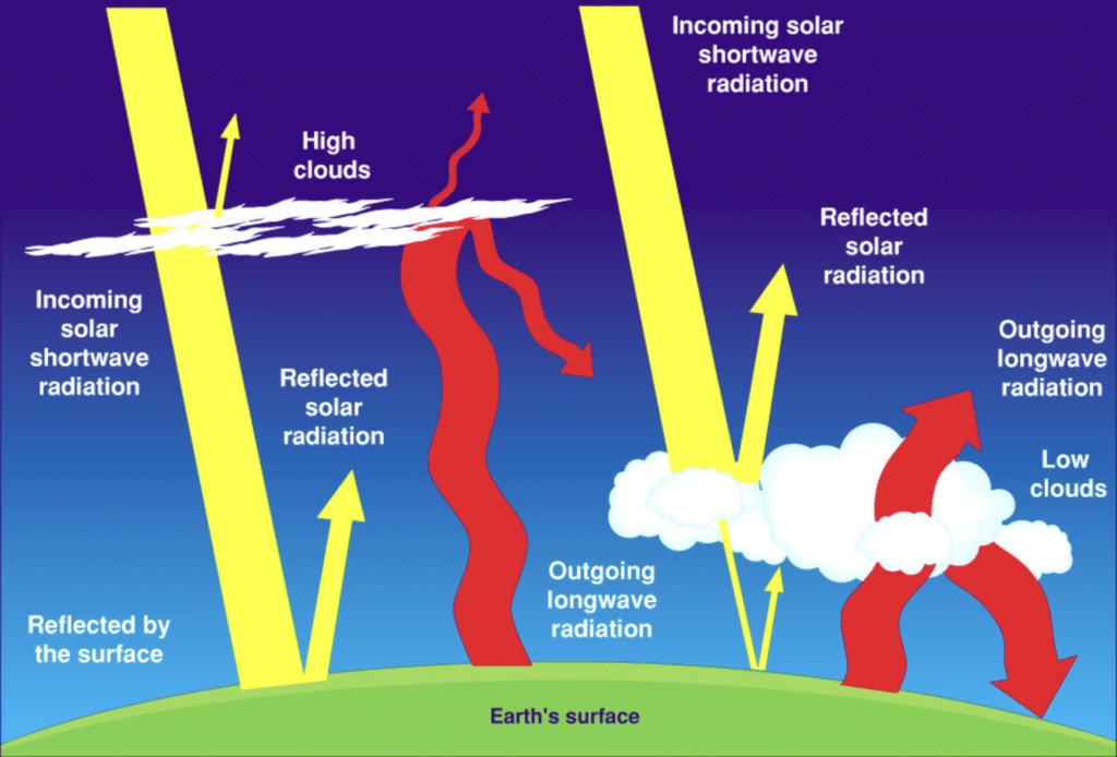
- High clouds are often thin and do not reflect very much. They let lots of the Sun’s warmth in. Low clouds are often quite thick and reflect lots of sunlight back into space.
- The main difference between high and low clouds is that the high clouds are colder. This means that they radiate less energy into space than the lower, warmer clouds. Therefore, high clouds work to “trap” more energy than low clouds.
- High clouds are not good at reflecting short waves. But, they are very good at blocking long waves. This also traps heat. Thus, high clouds will cause a warming of the Earth’s surface.
- Low clouds are excellent reflectors. But, they don’t stop the longwave energy from escaping to space. Therefore, low clouds help to cool the Earth.
High Clouds
- They can reach above 6000 metres or 20,000 feet.
- They are also known as Cirrus Clouds.
- They are usually thin and are made up of ice.
- They often indicate fair weather and hence do not produce rain.
Low Clouds
- They lie below 6,500 feet, which means from the surface to 2,000 meters.
- Low clouds are also known as Stratus Clouds.
- They may appear dense, dark, and rainy (or snowy) and can also be cottony white clumps interspersed with blue sky.
Q.“System of Rice Intensification” of cultivation, in which alternate wetting and drying of rice fields is practiced, results in:
- Reduced seed requirement
- Reduced methane production
- Reduced electricity consumption
Select the correct answer using the code given below:
(a) 1 and 2 only
(b) 2 and 3 only
(c) 1 and 3 only
(d) 1, 2 and 3
Answer: (d) 1, 2 and 3
System of Rice Intensification (SRI)
- It was first developed in Madagascar in the 1980s and since then several countries in the world have been practicing it, including India.
- It promises to save 15 to 20% groundwater and improves rice productivity, which is almost at a stagnant point now.
- As SRI reduces water requirements, electricity consumption for irrigation also reduces.
- It gives equal to or more productivity than conventional rice cultivation, with less water, less seed, and fewer chemicals. The net effect is a substantial reduction in the investments in external inputs.
- Benefits and Impacts of System of Rice Intensification
- To increase paddy yields usually by 20-50% and sometimes 100% or more;
- To reduce the required seeds for transplanting by 60-80%;
- To reduce the use of chemical fertilizers and agrichemicals;
- To reduce irrigation water by 25-50%;
- To reduce production costs usually by 10-20%; and
- With increased output and reduced costs, farmers’ net income is increased.
- The management methods of the System of Rice Intensification (SRI), by creating aerobic soil conditions through shallow and intermittent irrigation or alternate wetting and drying (AWD), bring about mostly aerobic soil conditions that sharply reduce methane emissions.
- Research has shown that intermittent paddy irrigation by SRI or AWD reduced methane emissions by between 22% and 64%.
