

- Latitude and longitude are the angular coordinates that fix the position of any point on the Earth’s surface; their network of intersecting parallels and meridians is called the graticule.
- Latitude tells how far a place lies north or south of the Equator; longitude tells how far it lies east or west of the Prime Meridian.
- Because the Earth turns through 360° of longitude in 24 hours, longitude also governs time: local time, standard time, time zones and the International Date Line all follow from it.
The Earth: Shape and Motions
Shape and Size of the Earth
- Earth is the third planet from the Sun in the Solar System, the largest and densest of the four terrestrial planets (with Mercury, Venus and Mars) and the fifth-largest planet overall.
- It formed about 4.54 billion years ago, along with the rest of the Solar System.
- About 71% of its surface is water and 29% land; roughly 97% of the water is saline, which is why it is called the blue planet.
- Earth is not a perfect sphere but an oblate spheroid (ellipsoid): flattened at the poles and bulging at the Equator.
- The bulge comes from rotation: the equatorial surface moves fastest, and the centrifugal effect throws mass outward there.
- The equatorial radius exceeds the polar radius by about 21 km, so the equatorial diameter is about 43 km greater.
- The geoid is the Earth’s true “Earth-shaped” figure: the equipotential surface of gravity that coincides with mean sea level and is extended under the continents.
- It is slightly irregular because mass is unevenly distributed inside the Earth; the smooth reference ellipsoid (WGS 84) is used for maps and GPS.
- Geodesy is the science that measures the Earth’s shape, size, gravity field and rotation.
| Measure | Value |
|---|---|
| Equatorial radius | 6,378.1 km |
| Polar radius | 6,356.8 km |
| Flattening | about 1/298 |
| Equatorial circumference | 40,075 km |
| Mean distance from the Sun | 149.6 million km (1 AU) |
| Axial tilt (obliquity) | 23.44° (about 23°26′) |
Rotation
- Rotation is the Earth’s spin on its axis, from west to east (anticlockwise when seen from above the North Pole).
- The Sun, Moon and stars therefore appear to rise in the east and set in the west.
- Two kinds of day follow from it:
- Sidereal day (one turn relative to the distant stars): 23 h 56 min 4 s.
- Mean solar day (Sun to Sun): 24 h, about 4 minutes longer, because the Earth also moves along its orbit and must turn a little further to face the Sun again.
- The linear speed of rotation falls with latitude: about 1,670 km/h at the Equator, about half that at 60°, and zero at the poles.
- Effects of rotation: day and night, the Coriolis force that deflects winds and currents, the tides’ daily rhythm, the equatorial bulge, and the link between longitude and time.
Revolution
- Revolution is the Earth’s motion around the Sun in an elliptical orbit, also anticlockwise when seen from above the North Pole, at a mean speed of about 29.8 km/s.
- The orbit is nearly circular (eccentricity about 0.017), so the Earth–Sun distance varies only a little.
- Perihelion: the Earth is nearest the Sun (about 147.1 million km) in early January, around 3 January.
- Aphelion: the Earth is farthest from the Sun (about 152.1 million km) in early July, around 4 July.
- The Earth is nearest the Sun during the northern winter, which shows that seasons come from the tilt of the axis, not from distance.
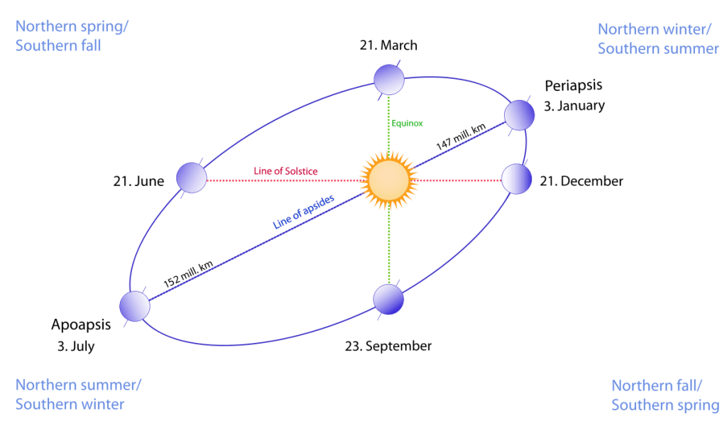
- The axis is inclined at about 66½° to the orbital plane (23½° from the perpendicular) and keeps pointing towards the Pole Star (Polaris) throughout the year.
- This parallelism of the axis makes the latitude of the vertical (overhead) Sun migrate between the two Tropics, producing seasons and changing lengths of day and night.
Leap Year
- One revolution takes about 365.2422 days (the tropical year, equinox to equinox), roughly 365¼ days.
- The calendar year has 365 days, so the extra quarter-day is gathered into a leap year of 366 days, with 29 February, about every four years.
- Gregorian rule: a year divisible by 4 is a leap year, but a century year is a leap year only if divisible by 400 (2000 was, 1900 was not).
Equinoxes and Solstices
- The overhead Sun’s migration gives the Earth four critical positions in its orbit.
| Position | Date | Overhead Sun | Day and night |
|---|---|---|---|
| Vernal (spring) equinox | 20 or 21 March | Equator | Nearly equal everywhere |
| Summer solstice | 20 or 21 June | Tropic of Cancer | Longest day in N. Hemisphere; 24-h day inside Arctic Circle |
| Autumnal equinox | 22 or 23 September | Equator | Nearly equal everywhere |
| Winter solstice | 21 or 22 December | Tropic of Capricorn | Shortest day in N. Hemisphere; 24-h night inside Arctic Circle |
- An equinox (“equal night”) is when the Sun stands over the Equator and the circle of illumination passes through both poles.
- A solstice (“Sun stands still”) is when the overhead Sun reaches its farthest point north or south and turns back; seasons are reversed in the Southern Hemisphere.
Latitude
Meaning and Measurement
- Latitude is the angular distance of a place north or south of the Equator, measured at the centre of the Earth along the place’s meridian.
- It runs from 0° at the Equator to 90°N and 90°S at the poles.
- Measuring latitude:
- In the Northern Hemisphere, the altitude of the Pole Star above the horizon roughly equals the place’s latitude.
- Anywhere, latitude can be worked out from the altitude of the noon Sun and the date.
Parallels of Latitude
- A parallel is the line joining all places of the same latitude; it runs east–west as a full circle parallel to the Equator.
- Properties:
- Parallels never meet; they shrink towards the poles, which are points, not lines.
- Drawn at 1° intervals there are 89 parallels in each hemisphere, 179 including the Equator.
- Only the Equator is a great circle; all other parallels are small circles.
- Length of a degree of latitude is nearly constant at about 111 km.
- It grows slightly from about 110.6 km at the Equator to 111.7 km at the poles, because the flattened Earth curves less near the poles.
Important Parallels
| Parallel | Latitude (current) | Length | Significance |
|---|---|---|---|
| Equator | 0° | 40,075 km | Longest parallel; divides Northern and Southern Hemispheres; about 79% of it crosses water |
| Tropic of Cancer | about 23°26′N | 36,788 km | Northernmost limit of the overhead Sun (June solstice) |
| Tropic of Capricorn | about 23°26′S | 36,788 km | Southernmost limit of the overhead Sun (December solstice) |
| Arctic Circle | about 66°34′N | about 16,000 km | Southern limit of the midnight Sun and polar night |
| Antarctic Circle | about 66°34′S | about 16,000 km | Northern limit of the midnight Sun and polar night |
- The Tropics lie at the latitude equal to the axial tilt, and the polar circles at 90° minus the tilt; the familiar round figures 23½° and 66½° are approximations.
- India: the Tropic of Cancer crosses eight states: Gujarat, Rajasthan, Madhya Pradesh, Chhattisgarh, Jharkhand, West Bengal, Tripura and Mizoram, dividing the country roughly into a tropical south and a subtropical north.
Shifting Tropics and Polar Circles
- These lines are not fixed: the tilt of the axis wobbles between about 22.1° and 24.5° over a cycle of about 41,000 years.
- At present the tilt is decreasing, so the Tropics are drifting towards the Equator by about 15 m a year, and the polar circles towards the poles by about the same distance.
- The Tropic of Cancer stood at 23°27′N in 1917 and will reach 23°26′N around 2045.
Heat Zones
- The five important parallels divide the Earth into heat (temperature) zones according to the angle of the Sun’s rays.
| Zone | Location | Sun’s rays | Character |
|---|---|---|---|
| Torrid Zone | Between the Tropics of Cancer and Capricorn | Overhead at least once a year | Hottest belt; small seasonal range |
| North and South Temperate Zones | Between each Tropic and its polar circle | Never overhead; angle varies with season | Moderate temperatures; distinct seasons |
| North and South Frigid Zones | Between each polar circle and its pole | Always slanting | Coldest; midnight Sun and polar night for part of the year |
- India lies mostly in the Torrid and North Temperate Zones, with the Tropic of Cancer running across its middle.
Longitude
Meaning and Meridians
- Longitude is the angular distance of a place east or west of the Prime Meridian, measured at the Earth’s centre in the plane of the Equator.
- It runs from 0° to 180°E and 180°W; 180°E and 180°W are the same line.
- A meridian is a semicircle from pole to pole joining places of the same longitude.
- All meridians are equal in length and converge at the poles.
- A meridian and its opposite (e.g. 0° and 180°) together make a great circle.
- Length of a degree of longitude falls with latitude, in proportion to the cosine of the latitude.
| Latitude | Length of 1° of longitude |
|---|---|
| 0° (Equator) | about 111.3 km |
| 30° | about 96.5 km |
| 60° | about 55.8 km |
| 90° (poles) | 0 km |
- Measuring longitude needs a time comparison: the local noon of a place is compared with the time at the Prime Meridian.
- At sea this became practical only with the accurate marine chronometer of John Harrison in the 18th century; today satellite navigation gives it directly.
Prime Meridian
- The Prime Meridian (0°) passes through the Royal Observatory, Greenwich, in London.
- It was adopted at the International Meridian Conference, Washington, D.C., October 1884, attended by 26 countries.
- The vote for Greenwich was 22 in favour, 1 against (San Domingo) and 2 abstentions (France and Brazil); France kept the Paris meridian for decades after.
- The meridian used today is the IERS Reference Meridian, which runs about 102 m east of the historic Greenwich line.
- The shift arises because the old line was fixed by astronomical observation, while the modern one is geodetic, referred to the Earth’s centre of mass, as used by GPS.
Hemispheres
- The Equator divides the Earth into the Northern and Southern Hemispheres.
- The Prime Meridian and the 180° meridian divide it into the Eastern and Western Hemispheres.
- The Eastern Hemisphere holds Asia, Australia, most of Africa and most of Europe, and the great majority of the world’s people.
- The Western Hemisphere holds the Americas and small parts of Europe, Africa, Antarctica and north-eastern Russia.
Latitude and Longitude Compared
| Basis | Latitude | Longitude |
|---|---|---|
| Measured from | Equator (0°) | Prime Meridian (0°) |
| Range | 0°–90° N and S | 0°–180° E and W |
| Lines | Parallels: full circles, run east–west | Meridians: semicircles, run north–south |
| Length of lines | Decreases towards the poles | All equal |
| Length of 1° | Nearly constant (about 111 km) | 111.3 km at the Equator to 0 at the poles |
| Great circles | Only the Equator | Every meridian pair |
| Main use | Climate, heat zones, insolation | Time, time zones, Date Line |
Great Circles
- A great circle is any circle on the globe whose plane passes through the Earth’s centre; it divides the globe into two equal halves.
- The shortest route between two points on the globe lies along a great circle, which is why long-haul flights and ships follow great-circle routes that look curved on flat maps (some flights from India to North America, for instance, take polar routes over the Arctic).
Longitude and Time
Time and Longitude
- The Earth turns 360° in 24 hours, so:
- 15° of longitude = 1 hour, and 1° = 4 minutes of time (1′ of arc = 4 seconds).
- Local time is the time fixed by the Sun at a place: it is noon when the Sun crosses the local meridian.
- Places east of a meridian are ahead in time; places west are behind.
- Worked example: when it is 12 noon at Greenwich, a place at 82°30′E is 82.5 × 4 = 330 minutes, or 5 h 30 min ahead, so it is 5:30 p.m. there.
- India: the country spans about 29° of longitude, from about 68°7′E to 97°25′E, so local time differs by nearly two hours.
- Local time at Dwarka (Gujarat) and Dibrugarh (Assam) differs by about 1 hour 45 minutes.
Standard Time and Time Zones
- If every town kept its own local time, clocks would differ from place to place, making railway timetables, telegraphs and administration unworkable.
- Standard time solves this: a country (or a zone) adopts the local time of one central meridian, the standard meridian, for all its territory.
- Standard meridians are usually chosen as multiples of 7½°, so that standard time differs from UTC by whole or half hours.
- Time zones: the world is divided into 24 zones of 15° each, each one hour apart in principle.
- Sir Sandford Fleming proposed a worldwide system of 24 zones in 1876; North American railways adopted zone time in 1883.
- In practice zone boundaries follow political borders, and offsets now range from UTC−12 to UTC+14; some use half- or quarter-hours (India +5:30, Nepal +5:45, Chatham Islands +12:45).
- Large east–west countries keep several zones, though some choose one for unity.
| Country | Time zones | Note |
|---|---|---|
| France | 12 | Most in the world, because of overseas territories |
| Russia | 11 | From Kaliningrad (UTC+2) to Kamchatka (UTC+12) |
| USA | 11 with territories | Four in the contiguous states |
| Canada | 6 | Newfoundland keeps a half-hour offset (UTC−3:30) |
| China | 1 | Beijing Time (UTC+8) despite spanning about 60° of longitude |
| India | 1 | IST (UTC+5:30) |
Indian Standard Time
- Indian Standard Time (IST) is the local time of the 82°30′E meridian, which is 5 h 30 min ahead of UTC (GMT).
- The meridian passes near Mirzapur (Vindhyachal) in Uttar Pradesh and runs through Uttar Pradesh, Madhya Pradesh, Chhattisgarh, Odisha and Andhra Pradesh.
- It lies near the centre of India’s longitudinal spread, so the error at either end is about an hour.
- Evolution:
- Before standardisation India used Bombay Time, Calcutta Time and Madras Time (the last as railway time).
- IST was introduced on 1 January 1906; after independence it became the national time, though Calcutta Time lasted until 1948 and Bombay Time until 1955.
- Keeping IST: the CSIR-National Physical Laboratory (NPL), New Delhi, maintains IST from its atomic clocks as UTC(NPLI) + 5 h 30 min.
- The Legal Metrology (Indian Standard Time) Rules, 2026, notified in August 2026 and effective 180 days after publication, make IST the single legal time reference for commerce, transport, administration, contracts and finance.
- Official networks must synchronise through NTP and PTP, and satellite-based timing devices must take at least one reference from NavIC or another authorised source, reducing dependence on GPS; scientific, astronomical and navigational uses are exempt.
- Debate over a second time zone:
- In the North-East, the Sun rises about two hours earlier than in western Gujarat; offices open long after sunrise and evenings need more electric lighting.
- Assam’s tea gardens have long kept an unofficial “chaibagan” (bagan) time, one hour ahead of IST.
- An NPL study (2018) proposed IST-I (UTC+5:30) for most of India and IST-II (UTC+6:30) for the seven north-eastern states and the Andaman and Nicobar Islands, divided at about 89°52′E on the West Bengal–Assam border.
- The Union government has kept a single time zone, citing strategic reasons and the risk of confusion in railways, aviation, banking and communication.
GMT, UTC and Leap Seconds
- Greenwich Mean Time (GMT) is the mean solar time at the Greenwich meridian; it was the world’s reference time from the late 19th century.
- Coordinated Universal Time (UTC) is the modern reference, based on atomic clocks (International Atomic Time) and kept close to the Earth’s rotation.
- In daily use UTC and GMT agree, but GMT is now only a time-zone name (the UK’s winter time), while UTC is the scientific standard on which all time zones are defined.
- Leap seconds: the Earth’s rotation is slightly irregular, so UTC has been adjusted by leap seconds to stay within 0.9 s of astronomical time (UT1).
- 27 leap seconds have been added since 1972, the last on 31 December 2016.
- The General Conference on Weights and Measures (CGPM), 2022, decided that the permitted gap will be enlarged in or before 2035, which in effect ends leap seconds, because they disrupt computer networks, satellite navigation and financial systems.
Daylight Saving Time
- Daylight saving time (DST) advances clocks, usually by one hour, in summer so that evenings stay light and lighting energy is saved.
- It was first widely used during World War I and is common in middle and high latitudes (Europe, most of North America), where summer days are long.
- Tropical countries gain little from it because day length varies little.
- India does not observe DST; it was used briefly during the 1962, 1965 and 1971 wars.
International Date Line
- The International Date Line (IDL) is the line, roughly along the 180° meridian, where the calendar date changes by one day.
- Why it is needed: a traveller going east from Greenwich gains an hour every 15°, reaching +12 hours at 180°E; one going west loses an hour every 15°, reaching −12 hours at 180°W.
- The two sides of the 180° meridian therefore differ by 24 hours, a whole day.
- Crossing rule:
- Crossing west to east (Asia to America): set the calendar back one day (the same date is repeated).
- Crossing east to west (America to Asia): skip a day (the date advances).
- Deviations: the line zigzags so that it runs through the sea and does not split a country or island group into two dates.
- It bends east around Chukotka (Russia) and west around the Aleutian Islands (USA), passing through the Bering Strait between the Diomede Islands.
- In the South Pacific it swings east to keep Fiji, Tonga and Kiribati on the Asian–Australian side.
- The line is not fixed by treaty; countries choose their own side, and have moved it:
- Kiribati‘s eastern islands skipped 31 December 1994 so that the whole country kept one date from 1 January 1995; its Line Islands (UTC+14) are the first inhabited land to begin each new day.
- Samoa (with Tokelau) skipped 30 December 2011 to share the working week with Australia and New Zealand, its main trading partners.
- Clock times on Earth span from UTC+14 (Line Islands) to UTC−12 (uninhabited Baker and Howland Islands), so for two hours each day three calendar dates are in use at once.
Previous Year Questions
- No direct PYQ has been asked on this sub-topic yet.





The geoid bulges at the North Pole and is depressed at the South Pole. Please check the sir in this line is it any spelling mistake.
Thanks, Gopi for pointing out the mistake, I have corrected the same. Keep reading.
Sir, Earth bulges at equator and flatten at pole because of CENTRIFUGAL FORCE is the correct one I think
Yes, Ajith
There are 179 latitudinal lines in 3D fig.(globe), we dont count equator twice.
and 181 latitudinal lines on 2D(map).
Hi bro, good to see some amazing stuff regarding geography optional! Kudos to your work! Are this articles are enough to cover entire geography optional? or do we need to study any other books?
Yes, here are the complete notes: https://lotusarise.com/optional/geography-optional-upsc/
Thank you so much for providing this much free content which is actually worth it and so informative.
the speed is 15 m/ year, not 15 km/year.
Thank you for pointing out the mistake.
equinox- 21st of march and 23rd of sep …..summer solstice 21st of June winter solstice 22nd Dec.
Diagram me date alag he or content me date alag he sir chang kr do bache confuse ho jaynge
Hello Rahul, thanks for pointing this out. Standard NCERT textbooks usually mention fixed dates (21 March, 21 June, 23 September, 22 December), which is why you see them in diagrams. However, astronomically, the exact timing can vary by a day due to leap years (e.g., 20/21 March, 20/21 June, 22/23 September, 21/22 December). Both are correct in their context, but I’ve highlighted the standard NCERT dates in bold to keep it completely clear for UPSC preparation.