

- Land capability is the ability of a land surface to support natural plant growth or wildlife habitat, and crops or human habitation.
- It therefore tells us which use suits a given tract: settlement, agriculture, pasture, forest or wildlife habitat.
- A capability survey judges what land could yield on a lasting basis, given its fertility, its present productivity and today’s level of technology.
- It separates what land is used for from what it can safely bear, and that makes it a basic document in any farm development plan.
The Idea and Its Spread
Why Capability Surveys Are Made
- A survey establishes the usefulness of land for agriculture, forest, industry, tourism and other purposes.
- With food in short supply, a country needs an inventory of its soil resources, which answers two questions:
- Which unused land could start yielding crops?
- Which farmed land could yield more than it does now?
- Laurence Dudley Stamp, who led the Land Utilisation Survey of Britain from the 1930s, held that knowing what land could do mattered more than recording its present use.
- Capability maps show problem areas and high-potential areas side by side, and so show where better technology and administration would raise output most.
- This matters most in a crowded, developing country such as India, where nearly all arable land is already ploughed.
Origin of the Surveys
- The Commonwealth Scientific and Industrial Research Organisation (CSIRO) used capability surveys to demarcate the land capability regions of Australia.
- The surveys were then widely applied in European and Anglo-American countries and in some Third World countries.
- The eight-class system in use today comes from the United States Department of Agriculture.
- Older accounts date its eight classes to 1951.
- A. A. Klingebiel and P. H. Montgomery of the Soil Conservation Service set out the standard version in Agriculture Handbook 210 (1961).
- It first divides land into that suited and that not suited to cultivation.
Land Classification, Capability and Suitability
| Term | What it does | Basis |
|---|---|---|
| Land use classification | Sorts land by its present use, as in the nine reporting classes | Village land records |
| Land capability | Grades land by its limitations and the range of uses it can bear | Soil, slope, climate, erosion hazard |
| Land suitability | Rates land for one named use, such as rice or orchard | Crop needs set against land qualities |
- A capability grouping is interpretive. It rests on assumed management levels, so its results can change as technology and farm practice change.
How Land Is Classed
Parameters Used
- Capability regions are delineated on physical parameters:
- Soil texture and structure
- Terrain, slope and run-off
- Temperature and precipitation
- The survey therefore leans heavily on soil survey results and on pedological conditions.
- Socio-economic factors can be added afterwards, at the stage when the map is turned into a development plan.
- Each soil group has its own physical and chemical properties, and these decide its capability and suitability. Two soil types show this well:
- Regur: cotton, sugarcane and citrus fruits.
- Alluvial soil: wheat, rice, maize, sugarcane, pulses and oilseeds.
- Each class can be split further:
- Subclass: names the main limitation, as e (erosion), w (excess water), s (soil limits in the rooting zone) or c (climate). Class I has no subclass, because it has no serious limitation.
- Capability unit: soils within a subclass that respond alike to the same management.
The Indian Scheme
- In India, the basic aim of soil survey was to achieve a land capability classification, first on the American pattern.
- That pattern suited American conditions better than Indian ones, so Indian workers looked for a scheme fitted to planning in a developing country.
- The All India Soil and Land Use Survey Organisation, now the Soil and Land Use Survey of India (set up in 1958), attempted a capability survey in 1960.
- A revised Soil Survey Manual (1970) removed many earlier weaknesses.
- The result is eight land use capability classes under two broad heads.
- Soil survey and land use planning research now also sits with the National Bureau of Soil Survey and Land Use Planning (Nagpur), an independent institute of the Indian Council of Agricultural Research since 1976.
Land Suitable for Cultivation
| Class | Land | Limitations and treatment |
|---|---|---|
| Class I | Very good arable land | No specific farming difficulty; nearly level, well drained, easy to work and very productive |
| Class II | Good farmland | Guard against erosion or floods, improve drainage, save irrigation water |
| Class III | Moderately good farmland | Close care over erosion, irrigation water, heavy drainage and flood protection |
| Class IV | Fairly good land for occasional or limited cultivation | Strong erosion and drainage works, with very heavy treatment of soil defects |
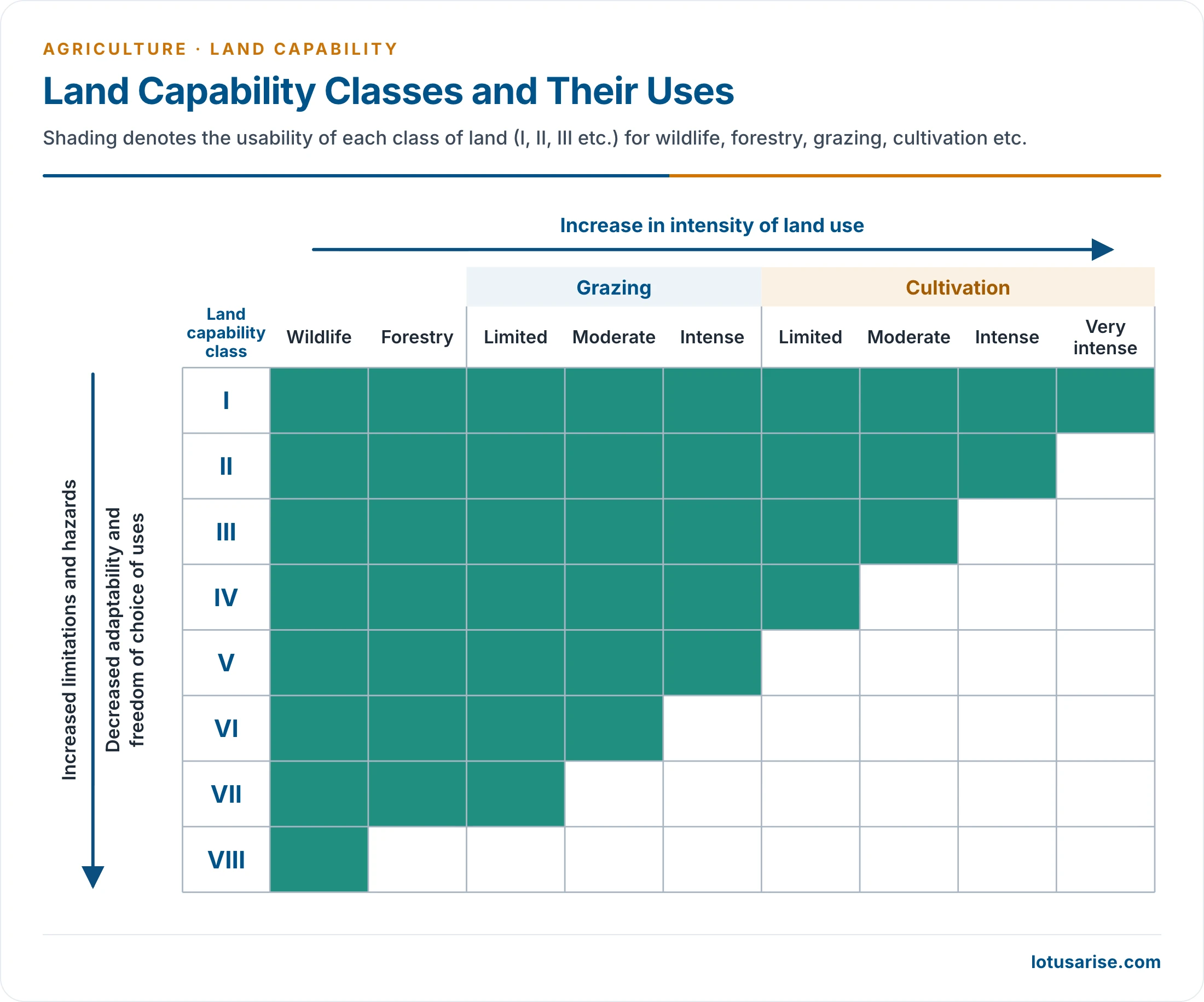
- The matrix reads from left to right. As the class number rises, the shaded range of uses shrinks: Class I carries everything from wildlife to very intense cultivation, and Class VIII carries wildlife alone.
Land Not Suitable for Cultivation
| Class | Land | Character |
|---|---|---|
| Class V | Very well suited to grazing and forestry | No crops; very good carrying capacity for livestock; needs protection from gullying |
| Class VI | Well suited to grazing and forestry | No crops; moderate carrying capacity; steep slope, severe erosion, stoniness, poor moisture retention, salinity, severe climate |
| Class VII | Fairly well suited to grazing or forestry | No crops; little carrying capacity |
| Class VIII | Wildlife only | Also recreation and protection of water supplies; severe climate, wet soil, stones, badlands, sandy beaches, marshes, deserts, nearly barren land |
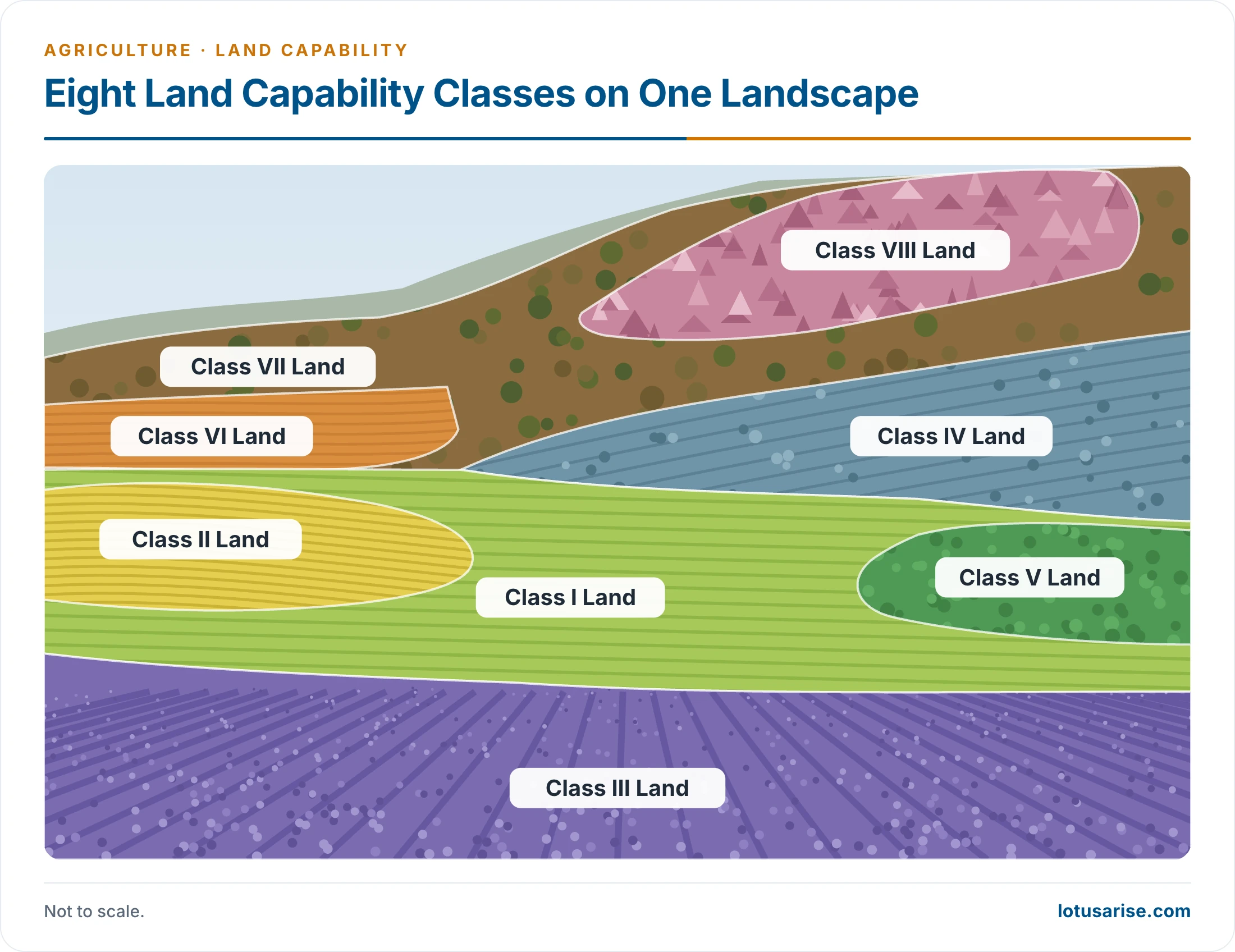
- The picture places the eight classes on one landscape: the best land lies on the level valley floor, and the classes worsen towards the steep, rocky upper slopes.
Significance in Land Use Planning
- The classification sets a use ceiling for any piece of land and defines its conservation problems and possible treatments.
- Land can then go to its most efficient use:
- Agricultural activity should stay within classes I to IV.
- Pasture, energy plantation, buildings and roads belong on classes V to VIII.
- Within this frame, the most suitable crop can be chosen for each plot.
- Classes are not fixed:
- Land can move up if a limitation is permanently removed or reduced by economically feasible reclamation: irrigation, proper drainage, flood control or the stabilising of gullies.
- Land can move down if existing conditions deteriorate, as under soil erosion and degradation.
- Regional use: with climate data, capability classes help divide a country into planning units, as in agricultural regionalisation and agro-climatic zoning.
- Capability and land use efficiency: capability measures what land could bear, while efficiency measures how well its present use turns inputs into output. Comparing the two exposes both under-used good land and over-used poor land, which is the case for a land use policy.
- Limits of the method:
- It grades soils by their limitations for farming, so it serves development plans best when climate and other physical factors are read with it.
- Its value rests on the quality of the soil survey behind it.
Previous Year Questions
2022How do agro-climatic and land capability indicators assist in the macro-agricultural regionalisation of India? Illustrate with an appropriate map.1992Write short note: Land capability versus Land use efficiency.1990What is the significance of land capability classification in land use planning? Explain the method of land capability classification adopted by the All India land use and soil survey organization.





very nice information .