

- Industrial regions are areas where industry has concentrated because of favourable geo-economic conditions. Manufacturing there runs on a relatively large scale and employs a relatively large share of the population.
- India’s factories are unevenly spread, since the factors of location differ from place to place. Most schemes recognise eight major regions, with minor regions and scattered industrial districts around them.
- The older pattern, tied to port hinterlands and the Chotanagpur coal and iron belt, is giving way to western and southern States and to corridors.
Industrial Regions
- An industrial region is much larger than an industrial complex: the Ruhr in Germany, or even a large part of a country, such as the Midlands in the UK.
- It often grows around a natural resource, frequently coal, iron ore or water, and is usually well served by transport arteries such as rail.
- It need not be homogeneous. Steel-making, power generation, primary food processing and service industries such as education can all lie within one region.
- Such areas need more labour than a complex, so residential areas stand nearby or even mixed in.
- Industrial district: Alfred Marshall first used this concept to describe aspects of the industrial organisation of nations.
- It is a place where workers and firms specialised in a main industry and its auxiliaries live and work.
- By the end of the 1990s such districts, in developed and developing countries alike, had drawn wide attention in debates on industrialisation and regional development policy.
- Regions emerge when many industries locate close to each other and share the benefits of closeness, drawn by favourable locational factors.
Delineating Industrial Regions
- Many geographers have delineated these regions empirically, using different parameters.
- Glenn Trewartha (1944), with a co-worker, first divided India into industrial regions, using employment figures.
- Pradyumna P. Karan and William M. Jenkins (1959) demarcated them next.
- Others include Joseph E. Spencer and William L. Thomas (1968), Ram Lochan Singh (R. L. Singh, 1971), B. N. Sinha (1972), M. R. Chaudhry (1976) and the Centre for Monitoring Indian Economy (1971, 1982).
- The early attempts are now dated, since planning has remade the industrial map.
- Indices used to identify clusters:
- Number of industrial units
- Number of industrial workers
- Population engaged in secondary activities
- Percentage of industrial workers to total workers
- Quantum of power used for industrial purposes
- Total industrial output (gross industrial output)
- Value added by manufacturing
| Scheme | Basis | Result |
|---|---|---|
| R. L. Singh (1971) | Empirical observation | Ten regions: Hugli, Mumbai, Ahmedabad, Ghaziabad–Amritsar, Lucknow–Kanpur, Bengaluru–Chennai, Kollam–Coimbatore, Madurai, Dalmiapuram, Digboi–Dibrugarh |
| B. N. Sinha (1972) | Daily factory workforce | Major region: at least 1.5 lakh. Minor region: at least 25,000. Manufacturing district: under 25,000 |
| Centre for Monitoring Indian Economy | Industrial employment | Centres above 10,000 workers in 1971 |
| Common current scheme | Concentration and workforce | Eight major and 13 minor regions, and 15 districts |
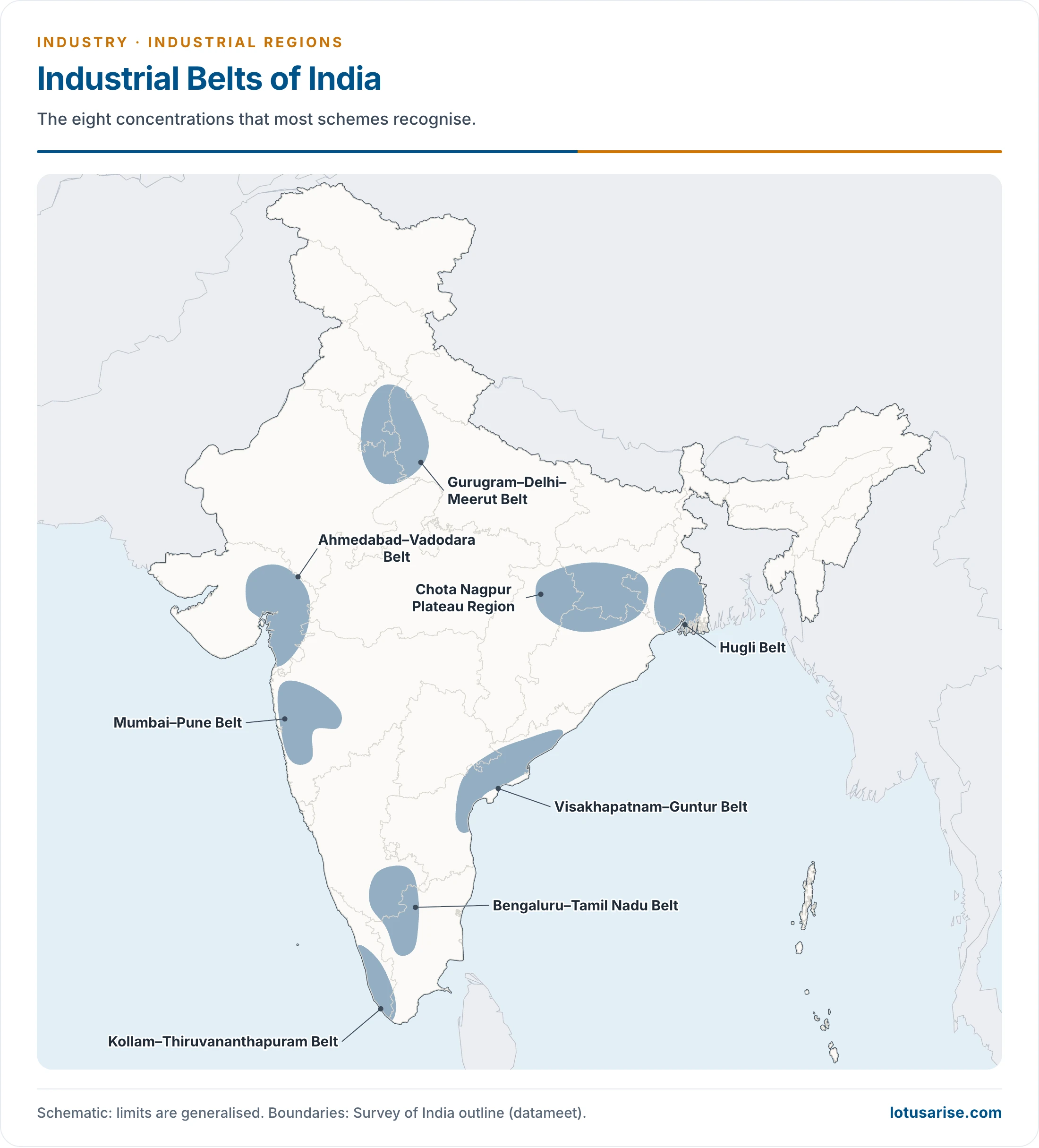
Industrial Regions of India
- India’s regions include the Mumbai–Pune cluster, the Bengaluru–Tamil Nadu region, the Hugli region, the Ahmedabad–Vadodara region, the Chotanagpur belt, the Visakhapatnam–Guntur belt, the Gurugram–Delhi–Meerut region and the Kollam–Thiruvananthapuram cluster.
- They fall into two types:
- Major industrial regions
- Minor industrial regions
- Origins: the major regions grew just behind the ports of Kolkata, Mumbai and Chennai, where the British found raw materials, power and markets. Better transport later brought in fuels such as coal.
The Major Industrial Regions of India
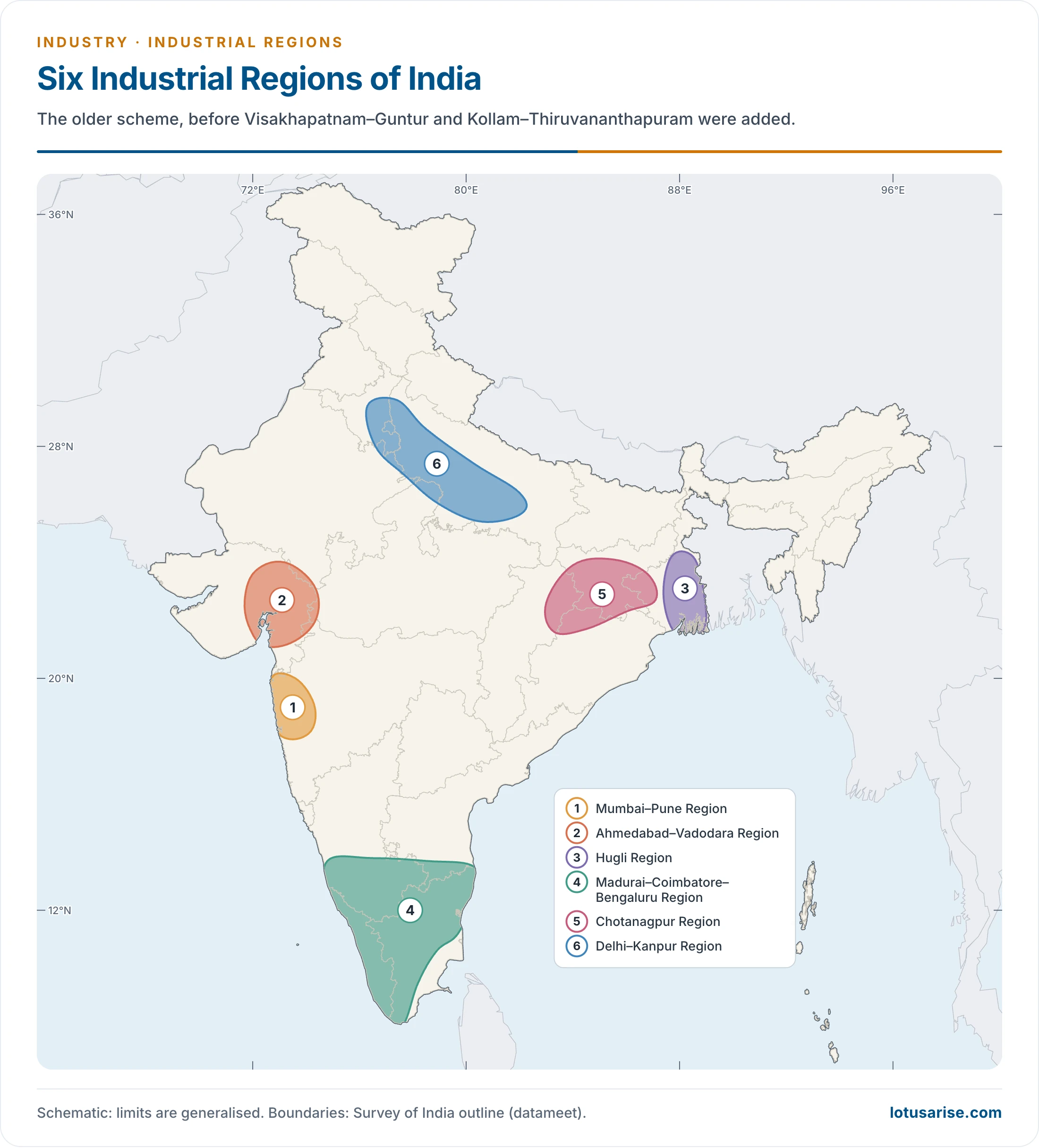
- Experts differ on the number. An older six-region scheme runs from Mumbai–Pune to Agra–Delhi–Kalka–Saharanpur, and Prof. R. L. Singh’s name is often attached to it.
- The eight-region scheme adds the Visakhapatnam–Guntur and Kollam–Thiruvananthapuram regions.
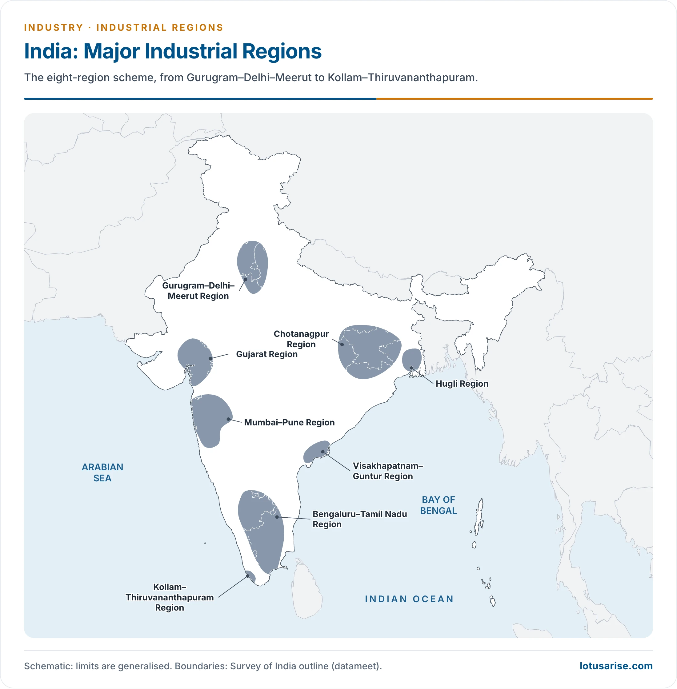
The Mumbai–Pune Industrial Region
- This is long described as the country’s most important industrial region.
- Extent: Thane to Pune and the adjoining districts of Nashik and Solapur, with growth in Raigad (Kolaba), Ahmednagar, Satara, Sangli and Jalgaon.
- Growth: the region grew after the British developed the Mumbai seaport, with the island site obtained in 1774.
- The first railway (Mumbai–Thane, 34 km, 1853) came first. The Bhor and Thal Ghat lines then opened the way to Pune and Nashik.
- The Suez Canal (1869) greatly shortened the voyage to Europe.
- The history of this region is closely tied to cotton textiles. It earned Mumbai the name Cottonopolis of India.
- Factors: humid climate, natural port, hydropower from the Western Ghats (coal lay far away), skilled and cheap labour, and a vast cotton hinterland on the black soils of the Narmada and Tapi basins.
- Older data: more than 8,000 registered factories in Greater Mumbai, of which 350 were cotton textile, and over 15 lakh industrial workers across the region.
- Other industries: engineering, chemicals, food processing, leather, pharmaceuticals and films, with fine and superfine cotton cloth in Mumbai.
- Mumbai High petroleum and nuclear energy added to the pull, bringing refineries, petrochemicals, fertilizers, electronics, software, shipbuilding and transport equipment.
- Pune is the second centre, with more than 1,200 registered factories in older data, producing metallurgical, chemical, engineering and automobile goods. It had two factories for scooters and mopeds.
- Other centres: Ambarnath, Andheri, Bhandup, Ghatkopar, Hadapsar, Jogeshwari, Kalyan, Kirkee, Kolhapur, Kurla, Nashik, Solapur, Thane, Trombay, Ulhasnagar, Vikhroli, Pimpri, Manmad, Ahmednagar, Satara and Sangli.
- Almost at saturation. Its problems:
- Inadequate power supply
- Obsolete and outdated machinery
- High cost of land and commercial rents
- Labour unrest
- Increasing regionalism
- High rate of crime
- Increasing environmental pollution
- Partition (1947) hurt the region, since 81% of the irrigated long-staple cotton area went to Pakistan.
- Limited space in Mumbai, the nucleus, makes dispersal essential for decongestion.
The Kolkata–Hugli Industrial Region
- Location: along the Hugli River, a narrow belt of about 100 km from Bansberia and Naihati in the north to Birlanagar in the south, with spread into Midnapur district in the west.
- The river gave an ideal setting for an inland port, around which the region formed. Kolkata–Haora remains its core.
- Factors:
- Agro-raw materials (jute, indigo and tea)
- Nearby coal at Raniganj and Jharia, and iron ore from Chotanagpur
- Abundant water
- Cheap labour from Odisha, Bihar, Jharkhand and eastern Uttar Pradesh
- Export facilities
- Capital of British India (1773 to 1911): this status drew industrialists and British capital to the region.
- The Rishra jute mill (1855) began modern clustering. By 1921 the region had two-thirds of India’s factory employment.
- Older data: over 10,000 registered factories and over 20 lakh workers.
- Specialisations: jute, silk, cotton textiles, engineering, electrical goods, automobiles, chemicals, pharmaceuticals, transport equipment, leather footwear, iron and steel, food processing, light machines, locomotives, and spare parts for machines.
- Landmarks: the Hindustan Motors plant near Konnagar, the Haldia refinery and Haldia port, which relieves pressure on Kolkata port.
- Main centres: Naihati, Bhatpara, Shamnagar, Krishnanagar, Serampore, Titagarh, Rishra, Kolkata, Haora, Budge Budge, Haldia, Shibpur, Kankinara, Sodepur, Belur and Triveni.
- Problems:
- Paucity of space and traffic jams
- Shortage of drinking water, insanitation and poor amenities
- Silting of the Hugli, which affects Kolkata port. Dredging keeps the channel at about 9.2 m, and the Farakka Barrage flushes it
- Obsolete machinery
- Naxalite movement and political unrest
- Strikes and lockouts
- Shortage of power
- After Partition the jute tract went to East Pakistan (now Bangladesh), and India raised its own production to fill the gap.
- West Bengal has pursued liberalisation and invited domestic and foreign investors, with some progress.
- Growth here has still been slower than elsewhere, and the decline of jute is a main cause.
The Ahmedabad–Vadodara (Gujarat) Industrial Region
- It was classically ranked the third largest industrial region.
- Extent: the nucleus lies between Ahmedabad and Vadodara, reaching Valsad and Surat in the south and Jamnagar in the west.
- Factors: cotton in the hinterland, cheap land, cheap skilled and unskilled labour, port facilities, and nearby petroleum, thermal, hydel (Ukai) and nuclear (Kakrapar) power.
- Textile history dates from the 1860s. As Mumbai declined, Ahmedabad gained: it lay nearer cotton and the markets of the Ganga and Satluj plains, while Mumbai paid freight twice.
- Older data: over 11,000 registered factories and over 15 lakh workers.
- It was the second largest cotton textile centre, and also makes chemicals, engineering goods and pharmaceuticals.
- Vadodara: woollen textiles and petrochemicals.
- Surat: silk textiles and diamond cutting.
- Oil in the Gulf of Khambhat area and the refineries at Koyali and Jamnagar fed petrochemicals around Ankleshwar, Vadodara and Jamnagar. Kandla port supports trade.
- Other centres: Anand, Ankleshwar, Bhavnagar, Bharuch, Godhra, Jamnagar, Kalol, Kheda, Rajkot and Surendranagar.
- Problems: water scarcity and shortage of good cotton. Communal tension has at times hurt investment.
The Bengaluru–Tamil Nadu (Madurai–Coimbatore–Bengaluru) Industrial Region
- It stretches over Tamil Nadu and southern Karnataka, and made great progress after independence.
- Mainly a cotton tract, led by cotton textiles and joined by silk, sugar, leather, chemicals, wagons, diesel engines, machine tools, aluminium, cement, glass and paper.
- Factors: a pleasant climate, disciplined workers of all skill levels, a large nearby market, and ports at Chennai, Kochi, Mangaluru and Thoothukudi.
- Hydropower from Mettur, Papanasam, Pykara, Sharavati and Sivasamudram offsets the distance from coal.
- About 60% of workers were in textiles, 18% in engineering and 12% in food processing in older data.
- Bengaluru: public sector units such as Hindustan Aeronautics, Hindustan Machine Tools, Indian Telephone Industries and Bharat Electronics pushed growth.
- Coimbatore, the “Manchester of Tamil Nadu”, grew on Pykara power and local cotton, and Madurai on cotton textiles.
- Other centres: Sivakasi, Tiruchirappalli, Mettur, Mysuru and Mandya, with Bhadravati’s steel works, the Salem steel plant and refineries at Manali and Narimanam.
The Chotanagpur Industrial Region
- It stretches over Jharkhand (southern Bihar before 2000), northern Odisha and western West Bengal.
- With its large iron and steel concentration, it is often called the “Ruhr of India”.
- Factors: coal of the Damodar valley and iron ore of the Jharkhand–Odisha belt in close proximity, other metallic and non-metallic minerals, and power from the Damodar Valley Corporation.
- Cheap labour comes from Bihar, Jharkhand, Odisha, Uttar Pradesh and West Bengal.
- Kolkata offers a market and a port.
- Iron and steel centres: Asansol, Bokaro, Burnpur, Durgapur, Kulti, Jamshedpur and Rourkela.
- Other centres: Sindri (fertilizer), Chittaranjan (locomotives), Ranchi (heavy engineering, often listed as HMT), and Ramgarh and Bhurkunda (glass), with nodes at Dhanbad, Chaibasa, Hazaribagh, Daltonganj, Garwa and Japla.
- Problems: power shortage and political unrest, such as Naxalite activity. Labour unrest has deterred investors.
The Gurugram–Delhi–Meerut (Agra–Delhi–Kalka–Saharanpur) Industrial Region
- Developed after independence, it has grown faster than most other regions.
- It has two belts: Agra–Mathura–Meerut–Saharanpur in Uttar Pradesh and Faridabad–Gurugram–Ambala in Haryana.
- Far from minerals and power sources, so its industries are light and market-oriented. Power comes from Bhakra-Nangal and thermal stations at Harduaganj, Faridabad and Panipat.
- Main centres and products:
| Centre | Industry |
|---|---|
| Agra | Textiles, tourism, glass |
| Ambala | Scientific instruments |
| Chandigarh | Electronic and strategic goods |
| Delhi | Textiles, chemicals, drugs, pharmaceuticals, light machines, electronic goods, food processing |
| Faridabad | Engineering |
| Ghaziabad | Synthetic fibre, chemicals, electronics, pharmaceuticals, farm equipment, iron and steel, cycle tyres and tubes |
| Gurugram | Automobiles |
| Kalka | HMT (the Pinjore unit nearby) |
| Mathura | Petrochemicals |
| Meerut | Sugar, textiles |
| Modinagar | Textiles, engineering goods, paper |
| Modipuram | Textiles |
| Mohannagar | Brewery, alcohol |
| Moradnagar | Ordnance |
| Noida | Automobiles, electronics |
| Panipat | Textiles, chemicals, food processing, refinery |
| Saharanpur | Paper, woodwork, sugar, textiles, food processing |
- Problems: high land prices, traffic jams and a high rate of crime.
The Visakhapatnam–Guntur Industrial Region
- Extent: from Visakhapatnam district to Kurnool and Prakasam, over most of coastal Andhra Pradesh, based on Visakhapatnam and Machilipatnam ports.
- Base: developed agriculture, minerals in the hinterland, and Godavari coal. Krishna–Godavari gas adds energy.
- Industries: Hindustan Shipyard (1941), refinery and petrochemicals, the coastal Visakhapatnam steel plant using Bailadila ore, a lead-zinc smelter in Guntur, sugar, textiles, paper, fertilizers, cement and aluminium.
- Centres: Visakhapatnam, Vijayawada, Vizianagaram, Rajamahendravaram, Kurnool, Eluru and Guntur.
The Kollam–Thiruvananthapuram Industrial Region
- A comparatively small region across Thiruvananthapuram, Kollam, Aluva, Ernakulam and Alappuzha.
- Far from the mineral belt, it relies on plantation crops and hydroelectricity, with agro-processing and market-oriented light industry.
- Industries: textiles, sugar, rubber, matches, glass, chemical fertilizers, food and fish processing, paper, coir, aluminium and cement. The Kochi refinery (1966) supports petrochemicals.
- Centres: Kollam, Thiruvananthapuram, Aluva, Kochi, Alappuzha and Punalur.
The Shift Since Liberalisation
- Old regions are losing ground to new western and southern belts, and the Annual Survey of Industries 2024-25 shows the change.
| Measure (share of India) | First | Second | Third |
|---|---|---|---|
| Factories | Tamil Nadu 15.44% | Gujarat 12.39% | Maharashtra 10.26% |
| Persons engaged | Tamil Nadu 14.99% | Maharashtra 13.08% | Gujarat 12.99% |
| Output | Gujarat 16.93% | Maharashtra 14.36% | Tamil Nadu 10.87% |
| Gross value added | Maharashtra 15.92% | Gujarat 14.10% | Tamil Nadu 10.90% |
| Fixed capital | Gujarat 19.87% | Maharashtra 12.26% | Tamil Nadu 8.53% |
- Karnataka and Uttar Pradesh follow in most measures, Haryana in persons engaged and Odisha in fixed capital. West Bengal is outside the top five on all of them.
- Newer belts: Baddi in Himachal Pradesh, Haridwar and Pantnagar in Uttarakhand, Sanand in Gujarat and the mineral-based Angul–Jharsuguda tract in Odisha.
- Corridors are drawing the map in a linear form along freight routes.
Limits of the Regional Idea
- Distribution is patchy. Many factories lie in metropolitan pockets and scattered towns, and vast areas between them have little industry.
- Criteria differ between schemes, so boundaries and even the number of regions change from author to author.
- Regions overlap and blur, as at Chotanagpur and Hugli, and they mix unrelated industries.
- Data dates quickly, because factory counts and specialisations shift with policy, and services and informal units are often missed.
- Even so, the regions remain useful for showing where agglomeration has occurred and what problems follow from it.
- Problems common to the regions: ageing plant, costly land, congestion, pollution, water and power stress, and labour disputes.
The Minor Industrial Regions of India
- Besides the major regions, several minor and emerging regions have grown.
- Kanpur–Lucknow: cotton, woollen and jute textiles, leather, fertilizers, chemicals, drugs, pharmaceuticals, electric goods and light machinery.
- Assam valley: petrochemicals, jute and silk textiles, tea processing, paper, plywood, matches and food processing, at Bongaigaon, Dibrugarh, Digboi, Guwahati, Noonmati and Tinsukia.
- Darjeeling–Siliguri: tea processing and tourism.
- North Bihar and eastern Uttar Pradesh: sugar, cement, glass, jute, fertilizers, locomotives, paper and food processing, at Prayagraj (Allahabad), Dalmianagar, Gorakhpur, Patna, Sultanpur and Varanasi.
- Indore–Ujjain: cotton textiles, chemicals, drugs, electronic and engineering goods, and food processing.
- Amritsar–Jalandhar–Ludhiana: sports goods, cotton and woollen textiles, hosiery, food processing and tourism.
- Nagpur–Wardha: textiles, engineering, chemicals and food processing.
- Godavari–Krishna delta: iron and steel, shipbuilding, fertilizer, rice milling, cotton textiles, sugar, fish processing, engineering and chemicals, at Guntur, Machilipatnam, Rajamahendravaram and Visakhapatnam.
- Dharwad–Belagavi (Dharwar–Belgaum): cotton textiles, chemicals, spice packing and food processing.
- Keralam (Kerala) coast: coconut oil, rice milling, fish packing, paper, coir matting, shipbuilding and petroleum refining at Kochi, and chemical and electronic goods.
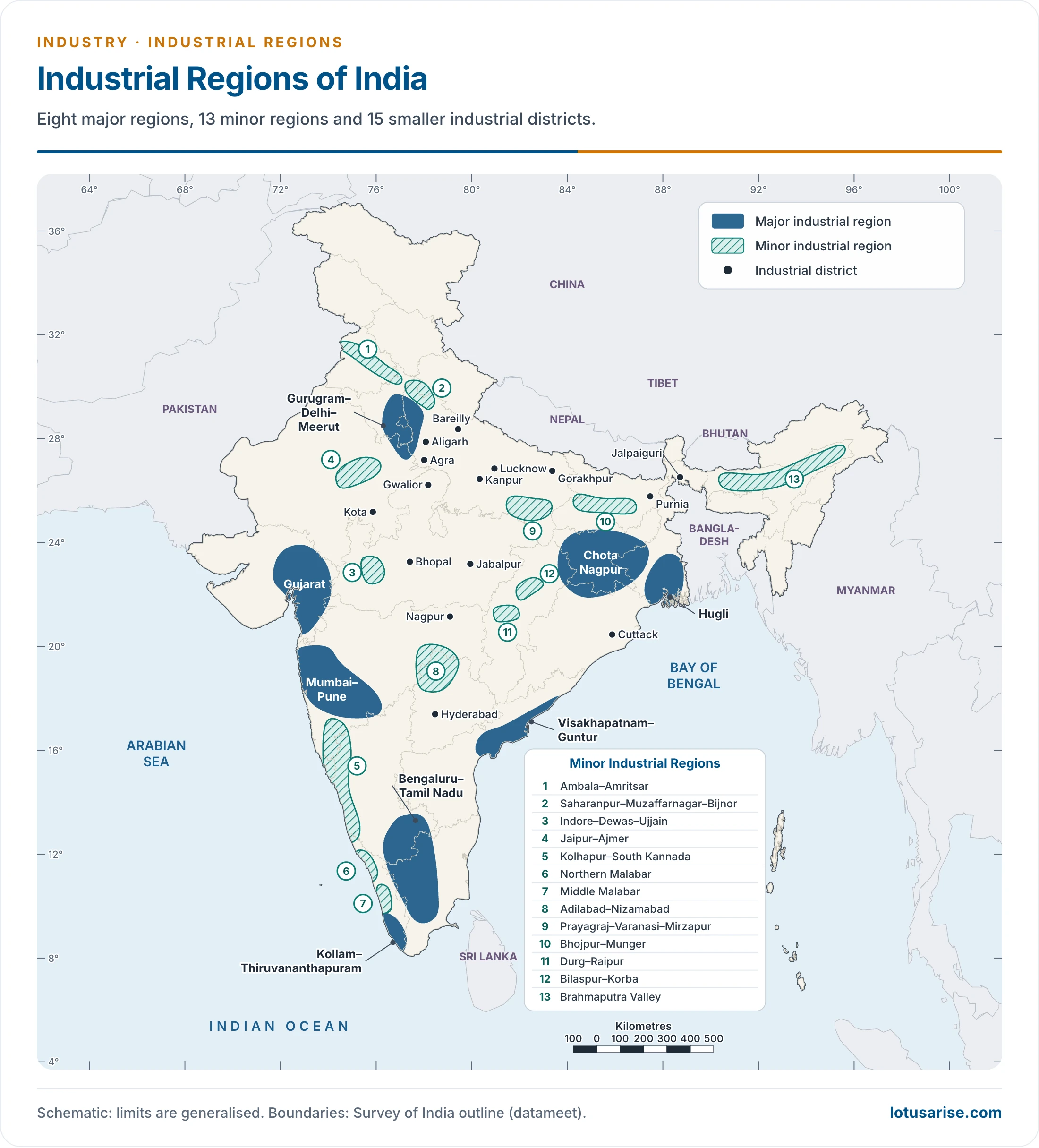
- The 13 minor regions on this map: Ambala–Amritsar, Saharanpur–Muzaffarnagar–Bijnor, Indore–Dewas–Ujjain, Jaipur–Ajmer, Kolhapur–South Kannada, Northern Malabar, Middle Malabar, Adilabad–Nizamabad (now in Telangana), Prayagraj–Varanasi–Mirzapur, Bhojpur–Munger, Durg–Raipur, Bilaspur–Korba and the Brahmaputra valley.
Agro-Industrial Regions
- Agro-based clusters follow their crops: sugar in western Uttar Pradesh, jute along the Hugli, plantation processing in Keralam, and food processing and farm machinery in Punjab and Haryana.
- Malwa has promise as an agro-industrial region, with cotton, soybean and wheat, the Indore–Ujjain–Dewas belt, and processing of cotton and oilseeds.
Industrial Districts
- These are the 15 smaller concentrations outside the regions, shown as dots on the map above:
- Kanpur
- Hyderabad
- Agra
- Nagpur
- Gwalior
- Bhopal
- Lucknow
- Jalpaiguri
- Cuttack
- Gorakhpur
- Aligarh
- Kota
- Purnia
- Jabalpur
- Bareilly
Previous Year Questions
2017Name the major industrial regions of India indicating the bases of their identification. Highlight their basic problems.2013Identify the main industrial clusters of India and account for their development.2013Distributional pattern of industries in India does not provide requisite basis for division of the country into distinct industrial regions. Elaborate.2012Identify the spatial pattern of agro-industrial regions of India. Analyse the potentiality of Malwa as an important agro-industrial region of the future.





Thanks for high quality, information rich resource for preparing the topic, Industrial Regions of India.
Most Welcome, Keep Reading
I guess the number 4 and number 5 industrial region in map has been interchanged. (3rd map)
In the fig 11.17 the region 4 and 5 is interchange so l would like to request to correct that cause diagram play an important role and if it remains incorrect then it might misled many students or readers. Thank you