

- A lake is a body of surface water enclosed by land. Rivers may feed it or drain it, so a lake can take water from a river or act as its source.
- Lakes occur in hills, plains, plateaus, rift zones and along coasts. India’s main groups are the glacial lakes of the Himalaya, the fault-guided lakes of Kashmir and Kumaon, the salt lakes of Rajasthan and the lagoons of both coasts.
- Their uses include drinking water, irrigation, navigation, water storage, livelihood through fishing, and an effect on local climate.
Types and Special Forms
Types of Lakes
- The main types of lakes can be classified on several bases:
- By water: freshwater, brackish and saltwater lakes.
- By origin: natural and artificial lakes.
- Oxbow lake: formed by river deposits, where a meander is cut off.
- Crater lake: a hollow of volcanic activity or meteorite impact that fills with water. Lonar is of the impact kind.
Subglacial Lakes
- A subglacial lake is liquid water lying between an ice sheet and the land beneath.
- It stays liquid because the ice above acts as an insulator, trapping geothermal heat from the crust.
- Lake Vostok is the largest of the Antarctic subglacial lakes, whose known number was put at almost 400 in older counts.
- It lies at the southern Pole of Cold, beneath Russia’s Vostok Station, under the central East Antarctic Ice Sheet.
- The station stands 3,488 m above mean sea level.
- A global inventory of 2022 catalogues 773 subglacial lakes, most of them in Antarctica.


Lakes of India
Key Facts
| Feature | Lake | State or UT | Note |
|---|---|---|---|
| Largest freshwater | Wular | Jammu and Kashmir | Tectonic origin; area varies with season |
| Largest brackish lagoon | Chilika | Odisha | About 906–1,165 sq km; older figures 780–1,144 |
| Longest | Vembanad | Keralam | About 96.5 km; older figure 75 km |
| Largest inland salt lake | Sambhar | Rajasthan | About 225 sq km in the rains |
| Highest, as long listed | Cholamu (Tso Lhamo) | Sikkim | About 5,330 m; figures vary |
| Largest reservoir by storage | Indira Sagar | Madhya Pradesh | 12.22 billion cubic metres |
| Long-listed largest artificial lake | Govind Ballabh Pant Sagar | Uttar Pradesh | Behind the Rihand Dam |
- Wular Lake, Jammu and Kashmir, is named the largest freshwater lake in India, and Chilika (Chilka) Lake, Odisha (Orissa), the largest saline water lake.
- Chilika is about 70 km long and up to about 22 km wide, narrowing to about 7 km in the south-west.
- It is the most heavily fished inland tract of the coast.
- Cholamu Lake, Sikkim, has long been listed as the highest lake in India.
- Vembanad Lake, Keralam (Kerala), is the longest lake. Kochi stands where it opens to the sea.
- Govind Ballabh Pant Sagar, behind the Rihand Dam, is the largest artificial lake in older lists. By storage, Indira Sagar on the Narmada is now the largest reservoir.
- Older accounts rank Dhebar Lake (Jaisamand) in Udaipur district of Rajasthan next after it.
- Salt lakes of Rajasthan: the inland drainage east of the Thar holds Sambhar, Didwana, Degana, Kuchaman, Sargol and Khatu.
- Sambhar lies about 65 km west of Jaipur at about 360 m, about 30 km long and 3–8 km wide, and it shrinks sharply in the dry season.
- Lagoons: the kayals of Keralam are shallow inlets parallel to the coast.
- Pulicat, about 40 km north of Chennai, is barred from the sea by the Sriharikota sand spit.
- Kolleru began as a shoreline lagoon. Growth of the Godavari–Krishna delta, about 35 km seaward, has since left it inland.
- Kashmir Valley itself was a Pleistocene lake, later filled with sediment. Naini Tal and Bhim Tal mark the Kumaon lake belt.
- Ramsar sites: India had 103 Ramsar sites as of 15 October 2026, when Sukhna Lake in Chandigarh and Sauj Jheel in Uttar Pradesh were added. The status marked below follows that list.
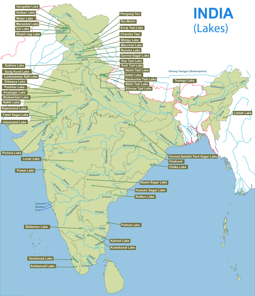
- On this map, “Chilka” is Chilika and “Hirakund” is Hirakud.
Andhra Pradesh and Telangana
| Lake | District or place | Type | Significance |
|---|---|---|---|
| Pulicat | Tirupati (Sullurpeta), with Tiruvallur in Tamil Nadu | Brackish lagoon | Bird sanctuary; Satish Dhawan Space Centre on Sriharikota |
| Kolleru | Between the Godavari and Krishna deltas, near Vijayawada | Freshwater | Migratory birds; Ramsar 2002 |
| Nagarjuna Sagar | Nalgonda and Palnadu | Freshwater, artificial | On the Krishna |
| Cumbum | Andhra Pradesh | – | – |
| Hussain Sagar | Hyderabad | Artificial | Rock island with a Buddha statue, once called Gibraltar rock |
| Bhadrakali | Warangal | Freshwater, artificial | – |
| Osman Sagar | Hyderabad | Artificial | On the Musi; city water supply |
| Himayat Sagar | Hyderabad | Artificial | On a Musi tributary |
| Pakhal | Warangal region | Artificial | – |
| Shamirpet | Near Hyderabad | Artificial | – |
| Saroornagar | Hyderabad | Artificial | – |
| Durgam Cheruvu | Rangareddy | – | – |
| Nizam Sagar | Kamareddy, near Nizamabad | Artificial | On the Manjra |
Assam and Arunachal Pradesh
| Lake | District or place | Type | Significance |
|---|---|---|---|
| Haflong | Dima Hasao, in the Silchar region | Freshwater | High-altitude lake |
| Deepor Beel | Kamrup | Freshwater | Ramsar 2002 |
| Son Beel | Sribhumi (Karimganj) | Freshwater, tectonic | Largest wetland in Assam |
| Chandubi | Kamrup | Freshwater | Winter birds; formed by the 1897 earthquake |
| Sela (Sala) | Tawang | – | Below Sela Pass |
| Sangestar Tso (Madhuri) | Tawang | – | – |
| Ganga (Geker Sinying) | Itanagar | – | – |
Bihar
| Lake | District or place | Type | Significance |
|---|---|---|---|
| Kanwar (Kabar Taal) | Begusarai | Oxbow, freshwater | Described as Asia’s largest freshwater oxbow lake; Ramsar 2020 |
Gujarat
| Lake | District or place | Type | Significance |
|---|---|---|---|
| Nal Sarovar | Ahmedabad–Surendranagar | Shallow wetland | Ramsar 2012 |
| Hamirsar | Kachchh | Artificial | Centre of Bhuj |
| Kankaria | Ahmedabad | Artificial | Built in 1451 under Sultan Qutb-ud-din Ahmad Shah II |
| Narayan Sarovar | Kachchh | Artificial, freshwater | Hindu pilgrimage site |
| Thol | Mehsana | Lentic | Built for irrigation; Ramsar 2021 |
| Vastrapur | Ahmedabad | Freshwater | Narmada water; picnic spot |
| Sursagar | Vadodara | – | – |
| Lakhota | Jamnagar | – | – |
Haryana, Punjab and Chandigarh
| Lake | District or place | Type | Significance |
|---|---|---|---|
| Badkhal | Faridabad | Freshwater, man-made | – |
| Blue Bird | Hisar | Freshwater | Migratory birds; wetland habitat |
| Brahma Sarovar | Thanesar | Freshwater | Ancient pool sacred in Hinduism |
| Damdama | Sohna | Freshwater | Built under British rule for rainwater harvesting |
| Karna | Karnal | Freshwater | Linked to the Mahabharata |
| Tilyar | Rohtak | Freshwater, canal-fed | Inside Tilyar Zoo |
| Surajkund | Faridabad | – | – |
| Harike | Ferozepur | Freshwater | Satluj–Beas meeting point; Ramsar |
| Rupar (Ropar) | Rupnagar | Freshwater | Man-made, riverine; Ramsar 2002 |
| Kanjli | Kapurthala | Freshwater | Ramsar 2002 |
| Sukhna | Chandigarh | Artificial | Ramsar, 15 October 2026 |
Himachal Pradesh
| Lake | District or place | Type | Significance |
|---|---|---|---|
| Chandra Taal | Lahaul and Spiti | Freshwater, high altitude | Ramsar 2005 |
| Suraj Taal | Lahaul and Spiti | Freshwater, high altitude | Source of the Bhaga |
| Maharana Pratap Sagar (Pong) | Kangra | Freshwater, artificial | On the Beas; Ramsar 2002 |
| Prashar | Mandi | Holomictic, freshwater | Floating island |
| Renuka | Sirmaur | Freshwater | Ramsar 2005 |
| Nako | Kinnaur | High altitude | – |
| Govind Sagar | Bilaspur | Artificial | Behind Bhakra Dam on the Satluj |
| Bhrigu, Macchial | Kullu, Mandi | – | Shown on the map |
Jammu and Kashmir, and Ladakh
| Lake | District or place | Type | Significance |
|---|---|---|---|
| Dal | Srinagar | Warm monomictic | Remnant of a past glacial period |
| Wular | Bandipora | Freshwater, tectonic | Ramsar 1990; the Jhelum flows through it |
| Anchar | Srinagar | – | – |
| Manasbal | Ganderbal | – | – |
| Gadsar | Ganderbal | Alpine | – |
| Gangabal | Ganderbal | Alpine | – |
| Vishansar | Ganderbal | Alpine | – |
| Mansar | Samba | – | With Surinsar, Ramsar 2005 |
| Marsar | Pulwama | Alpine | – |
| Tarsar | Anantnag | Alpine | – |
| Sheshnag | Anantnag | Alpine | On the Amarnath route |
| Tulian | Pahalgam | Alpine | – |
| Pangong Tso | Ladakh | Endorheic, saline | Stretches across the India–China frontier into Tibet |
| Tso Moriri | Ladakh | Brackish, high altitude | Ramsar 2002 |
Karnataka
| Lake | District or place | Type | Significance |
|---|---|---|---|
| Agara | Bengaluru | Freshwater | South-east of the city |
| Bellandur | Bengaluru | Freshwater | – |
| Karanji | Mysuru | – | Butterfly park |
| Ulsoor | Bengaluru | Stale water | Several islands |
| Kukkarahalli | Mysuru | Freshwater | Recreation |
| Honnamana | Kodagu | Freshwater | Holy lake; festivals |
| Pampa Sarovar | Hampi | Freshwater | Tungabhadra side |
| Hebbal | Bengaluru | – | – |
Keralam
| Lake | District or place | Type | Significance |
|---|---|---|---|
| Ashtamudi Kayal | Kollam | Brackish | Ramsar 2002 |
| Kuttanad | Alappuzha, Kottayam | Backwater tract | Paddy below sea level |
| Vembanad | Alappuzha, Kottayam, Ernakulam | Brackish | Ramsar 2002; boat race |
| Sasthamkotta | Kollam | Freshwater | Ramsar 2002 |
| Vellayani | Thiruvananthapuram | – | – |
Madhya Pradesh
| Lake | District or place | Type | Significance |
|---|---|---|---|
| Bhojtal | Bhopal | Freshwater, artificial | Ramsar, as Bhoj Wetland |
Maharashtra
| Lake | District or place | Type | Significance |
|---|---|---|---|
| Salim Ali | Chhatrapati Sambhajinagar (Aurangabad) | Freshwater | Birdwatching |
| Shivsagar | Satara | Freshwater, artificial | Behind Koyna Dam |
| Lonar | Buldhana | Impact crater, saline | National Geo-Heritage Monument; Ramsar 2020 |
| Gorewada | Nagpur | – | – |
| Pashan | Pune | – | – |
| Powai | Mumbai | – | – |
| Rankala | Kolhapur | – | – |
| Venna | Mahabaleshwar | – | – |
| Tulsi | Mumbai | – | – |
| Vihar | Mumbai | – | – |
| Mulshi | Pune | Artificial | On the Mula |
North-East: Manipur, Meghalaya, Mizoram and Sikkim
| Lake | District or place | Type | Significance |
|---|---|---|---|
| Loktak | Bishnupur, Manipur | Lenticular, freshwater | Ramsar 1990; phumdis, the floating islands; multipurpose project |
| Umiam | Near Shillong | Freshwater, artificial | Cycling and boating |
| Tam Dil | Saitual, Mizoram | Freshwater | – |
| Tsomgo | Gangtok (East Sikkim) | Freshwater | Frozen in winter |
| Khecheopalri | West Sikkim | Freshwater | Sacred to Hindus and Buddhists; Ramsar |
| Gurudongmar | North Sikkim | High altitude | North of the Kanchenjunga range |
Odisha
| Lake | District or place | Type | Significance |
|---|---|---|---|
| Chilika | Puri, Khordha, Ganjam | Brackish lagoon | Ramsar 1981 |
| Kanjia | Bhubaneswar | Freshwater | Wetland of national importance |
| Anshupa | Cuttack | Freshwater | Left bank of the Mahanadi; Ramsar |
| Hirakud | Sambalpur | Artificial | Mahanadi; Ramsar |
Rajasthan
| Lake | District or place | Type | Significance |
|---|---|---|---|
| Sambhar | Sambhar Lake town, near Jaipur | Saltwater | Ramsar 1990; largest inland salt lake |
| Rajsamand | Rajsamand | Freshwater, artificial | – |
| Dhebar (Jaisamand) | Udaipur | Artificial | – |
| Kaylana | Jodhpur | – | – |
| Nakki | Mount Abu | – | – |
| Pachpadra | Balotra | Saline | – |
| Man Sagar | Jaipur | – | – |
| Didwana | Nagaur region | Saline | – |
| Lunkaransar | Bikaner | Saline | – |
| Anasagar | Ajmer | – | – |
| Talwara | Hanumangarh | – | – |
| Pushkar, Fateh Sagar, Pichola, Shakambari | Ajmer, Udaipur, Sambhar area | – | Shown on the map |
Tamil Nadu
| Lake | District or place | Type | Significance |
|---|---|---|---|
| Ooty | Nilgiris | Freshwater | Boat house |
| Chembarambakkam | Near Chennai | Artificial | Chennai water supply |
| Kodaikanal | Dindigul | Artificial | Boat club and boat service |
| Kaliveli | Viluppuram | Coastal lake and lagoon | – |
| Kolavai | Chengalpattu | – | – |
| Puzhal (Red Hills) | Near Chennai | – | Chennai water supply |
| Sholavaram | Near Chennai | – | – |
| Berijam | Dindigul | – | – |
| Veeranam | Cuddalore | – | – |
Uttar Pradesh, Uttarakhand and West Bengal
| Lake | District or place | Type | Significance |
|---|---|---|---|
| Govind Ballabh Pant Sagar | Sonbhadra | Man-made | Behind Rihand Dam |
| Belasagar | Kulpahar | Freshwater | Irrigation |
| Bhimtal | Nainital | Freshwater | Medium altitude |
| Naini Tal, Sat Tal, Naukuchia Tal, Khurpa Tal | Nainital | – | Shown on the map |
| Deo Tal, Dodi Tal | Chamoli, Uttarkashi | – | Shown on the map |
| East Kolkata Wetlands | Kolkata | Brackish | Ramsar 2002 |
Important Lakes of the World
Which Water Bodies Count as Lakes
- The world’s largest lakes are usually listed leaving out the Caspian Sea, which is too big for most such lists, though it is still a lake.
- The Black Sea is not a lake, because the Bosporus and Dardanelles connect it to the Mediterranean.
- Many big rivers fall into it, so its surface salinity is about 17‰, half that of the ocean.
- The Caspian Sea and the Dead Sea are lakes.
Named Lakes
- Lake Baikal: a rift lake in southern Siberia, Russia, long and crescent-shaped.
- It is the largest freshwater lake by volume, holding 22–23% of the world’s fresh surface water, and the oldest (25–30 million years) and deepest, at 1,642 m (5,387 ft).
- It is seventh in the world by surface area. UNESCO listed it as a World Heritage Site in 1996.
- The land to its east is Transbaikalia, and the loose region around it is Baikalia.
- Baikal-GVD (Gigaton Volume Detector): one of the three largest neutrino detectors, with IceCube at the South Pole and ANTARES in the Mediterranean, launched by Russian scientists to trace these elusive particles and their sources.
- Lake Tanganyika: the longest lake in the world (660 km), and second in both volume and depth, after Baikal.
- Great Lakes of North America: interlinked freshwater lakes reaching the Atlantic through the Saint Lawrence Seaway.
- West to east: Superior, Michigan, Huron, Erie, Ontario. By size: Superior, Huron, Michigan, Erie, Ontario.
- Lake Superior is the largest continental lake by area, and Lake Michigan the largest wholly in one country.
- They are a major water corridor for bulk goods, through the Great Lakes Waterway.
- Dead Sea (Salt Sea): borders Jordan to the east, and Palestine and Israel to the west. Its surface and shores are Earth’s lowest land.
- Older accounts give 423 m and 418 m below sea level. It stands at about 430 m and is still falling.
- It is among the lakes with the highest salt concentration.
- Aral Sea: lay between Kazakhstan to the north and Uzbekistan to the south. It has shrunk since the 1960s, after Soviet irrigation projects diverted its rivers.
- African Great Lakes: part of the Rift Valley lakes in and around the East African Rift, including Lake Victoria, the largest in Africa, and Lake Tanganyika.
World Records
- Highest: the crater lake of Ojos del Salado (6,390 m) in the Andes, if size is ignored. The highest large lake is Pumoyong Tso (5,018 m) in Tibet.
- Highest commercially navigable: Lake Titicaca (3,812 m), on the Peru–Bolivia border and the largest in South America.
| Continent | Largest lake by surface area |
|---|---|
| Australia | Lake Eyre, a salt lake |
| Africa | Lake Victoria |
| Antarctica | Lake Vostok, subglacial |
| Asia | Lake Baikal, or the Caspian if counted, which is shared across Eurasia |
| Europe | Lake Ladoga, then Lake Onega, north-western Russia |
| North America | Lake Superior |
| South America | Lake Titicaca; Maracaibo, larger, is open to the sea |
| Rank, Caspian excluded | By surface area | By volume | By depth |
|---|---|---|---|
| 1 | Superior, North America | Baikal, Asia | Baikal, Asia |
| 2 | Victoria, Africa | Tanganyika, Africa | Tanganyika, Africa |
| 3 | Huron, North America | Superior, North America | – |
| 4 | Michigan, North America | – | – |
Previous Year Questions
2024Map item: Lunkaransar2021Map item: Khecheopalri Lake2018Map item: Mulshi Lake2017Map item: Pangong Lake2016Map item: Pulicat Lake2014Map item: Vembanad Lake





Thank youu so much….Sir please please cover geography optional series as soon as possible…soo deep request
Most Welcome, Sure
Can u provide pdf of geography notes
Dev, I have to write a lot of articles, so please give me some time after writing a complete course of geography Mains + Optional, I will start the compilation of notes. My Humble request to you that please make sort notes from our articles.
You are doing yeoman’s service to Geography students
Such an awesome content.
Ur notes r ultimate unmatchable… Thanks a lot
Very useful content
Thanku so much for this content
And sir pls provide history notes also
All the important facts at one place thanks 4 dis
Sir, Please provide the PDFs as soon as possible🥺I m tired of screenshotting and converting them into pdfs🥺
No neee to worry dear, You can turn webpage in desktop mode and then click on share button in your browser, by clicking on share button, new interface will show you various option, Now you have to click on “Print” Option..It will directly convert into pdf file in your Google drive or Storage also..
Sir Please Edit , Karachi Lake
It is not “Karachi Lake” , It is Karanji Lake.
It is mistyped..
Thank You..📚🙏
Thank You.
Is this notes are enough for geography optional
No.
Everywhere half info is available when will be upsc ask it is almost not any coaching web
Thanks, great initiative by Lotus arise, material like this very important for the students like us living in the remotest villages of Nankhari (himachal pradesh ),love from Shimla
Gobind vallabh pant sagar is in uttar pardesh not in Rajasthan