

Regional Imbalances

- Regional imbalance is defined as a state of disequilibrium in terms of economic and social criteria existing between two regions over the landscape.
- It is a condition in which an economy fails to extend benefits equally to all regions in the country or class in society.
- This uneven economic development is either due to historical processes like colonialization or due to socio-economic processes.
- It exists both in capitalist and socialist countries, for example, capital concentration in West Europe and North America.
- Regional imbalance can be spatial (inter-regional imbalance such as Eastern Uttar Pradesh and Western Uttar Pradesh, intraregional such as Uttar Pradesh and Punjab) or social (class differentiation such as regions with the dwellings of the people from lower cast may be less developed than that of the higher cast)
- Regional Imbalance has two dimensions
- Regional disparity and development
- Class differentiation
- Regional imbalance can further be classified into
- Inter-Regional imbalance (Eastern and Western India)
- Intra-Regional imbalance (Vidarbha and Western Maharashtra, Coastal Andhra Pradesh is more developed, in USA North East area is more developed)
- Natural resources and geographical factors like location and accessibility are not homogenous. The landscape never follows the “principle of isomorphism”. Regional imbalances are the result of such heterogeneous character of the physical nature of the earth.
- At one place it has all the natural advantages while others may have a disadvantage or physical constraints to growth.
- However, the spread of human phenomenon introduces even more variability by its technological application and difference across the landscape in terms of socio-economic growth are aggravated and disequilibrium sets on with a typical characteristics flow pattern where a segment of earth or region attracts resources, people, factors of production and involve into a gigantic economic force by extracting and desertifying the surrounding (e.g. Bhilai region has attracted factors of production and has emerged as a developed town, but the surrounding areas have been desertified in terms of growth and development).
Thus, Regional imbalance refers to the disequilibrium or disparity in terms of resource, productive economic growth, an assemblage of factors of production between two or more regions, culminating into development disparities, regional consciousness, and generating a flow pattern towards the developed region and polarisation, agglomeration and fused economic growth.
- Universal Phenomenon: Regional imbalances are a universal feature of both capitalist and socialist countries. Even the richest country in the world — the USA — has the problem of imbalanced regional development. Small countries like Italy (North-South divide) and France (Paris vs. provinces), and socialist countries like Russia (Moscow vs. Siberia) and China (Eastern coast vs. interior), all experience this phenomenon.
- Different regions of a country grow at very unequal rates, resulting in inter-regional and intra-regional disparities, which in turn generate serious socio-economic problems.
Types of Disparities/Imbalances
- Regional imbalance can be broadly classified into two major dimensions — spatial and social:
- Spatial Imbalance
- Geographical inequality in economic and social development across territorial units. Has two subtypes: Inter-regional and Intra-regional.
- Social Imbalance
- Inequality between social groups within a region — based on caste, class, gender, religion, or ethnicity. Spatially manifest when certain communities are geographically concentrated.
- Spatial Imbalance
Spatial Imbalances: Inter-regional and Intra-regional
| Type | Definition | Scale | Indian Examples |
|---|---|---|---|
| Inter-Regional Imbalance | Disparity between two or more distinct regions within the same country | State-to-state, macro-regional | Uttar Pradesh vs. Punjab; Bihar vs. Maharashtra; North-East states vs. Western India |
| Intra-Regional Imbalance | Disparity within a single state or region between its sub-units | Within-state, meso/micro level | Vidarbha vs. Western Maharashtra; Coastal Andhra vs. Rayalaseema; Eastern UP vs. Western UP |
Social Imbalance
- Social imbalance refers to class differentiation — regions with the dwellings of people from lower castes may be less developed than those of higher castes. This creates a spatial expression of social inequality. Examples:
- Dalit-dominated villages in UP/Bihar are spatially more deprived than upper-caste villages
- Tribal areas of Chhattisgarh, Jharkhand, and Odisha lag in all development indicators
- Gender-based spatial inequality — districts in Bihar and Rajasthan with low female literacy are also economically lagging
Other Classification Frameworks
- Global Disparity:
- The term global disparity describes the disparities that exist between nations. Each country is at a different level of development, which causes a disparity between countries. Some counties have been endowed with resources in abundance, while there are countries that are extremely poor in resources.
- Inter-State Disparity:
- Like global disparities, there are also exist disparities between the states in India. Interstate disparities or regional disparities or regional imbalances refer to a situation where a per capita income, standard of living, consumption situation, industrial and agriculture development are not uniform in different parts of a given region. The backwardness of the state could be the result of either regional diversity or disparity.
- Intra-State Disparity:
- Intrastate disparity refers to disparity within the state. Intra-regional disparities in development can be identified through macro indicators of development like allocation of resources, quality of governance, agrarian structure, income, consumption patterns, and estimates of poverty.
- Rural-Urban disparity:
- The rural-urban disparity has been prevalent in India for ages. Rural areas are considered backward areas in terms of availability of the basic infrastructure – roads, electricity, water and sanitation facilities, schools and hospitals, etc. In contrast, these facilities are mostly available in urban areas. It is because of the absence of such facilities that rural areas lag behind urban areas in terms of the basic indicators of development – poverty, illiteracy, unemployment, etc.
| Dimension | Global Disparity | Regional Imbalance |
|---|---|---|
| Scale | Between nations | Within a nation — between states, districts, or regions |
| Focus | North-South divide; Developed vs. Developing world | Core vs. Periphery within the same country |
| Example | USA vs. Haiti; Germany vs. Ethiopia | Maharashtra vs. Bihar; Punjab vs. Assam (within India) |
| Cause | Colonialism, terms of trade, technology gap | All causes of global disparity + internal policy failures, geography, history |
| Measurement | GNI per capita, HDI between countries | NSDP per capita, literacy, IMR between states/districts |
Types of Regional imbalances/Regional classification of the world
In 1911, 1st regionalization was provided which divided world into
- Developed: It includes Anglo-America, Western Europe, Australia, etc. where all measures of economic development found to be high.
- Quasi developed: These are the regions with a high resource base and development has only intensified in the 20th century. E.g. Eastern Europe, South Africa, Brazil, Argentina, etc.
- Underdeveloped: It includes countries of Africa, India, China, etc.
Classification based on population and resource by Ackerman
- E.A. Ackerman (1970) has used three basic criteria for formulating the world’s regional scheme of population /resource ratio. These criteria were -Population factor, resource factor, and technology factor. He suggested a five-fold classification of the world into population/resource regions:
- The United States of America Types: About one-sixth of the world’s people live in technology-source areas with low population/resource ratios, as in much of North America, Australia, and New Zealand and the erstwhile Soviet Union
- European Type/Russian Type: One-sixth live in technology-source areas with high population/resource ratios, where industrialization and technology have permitted an expansion of resources through international trade. Most of Europe and Japan fall in this category
- Egyptian Type: Roughly one-half live-in areas which are technology deficient with high population/resource ratios, as in India, Pakistan, and China. This type epitomizes some of the most severe population problems.
- Brazilian Type: One-sixth live in technology-deficient areas with low population/resource ratios, as in much of Latin America, Africa and South-East Asia, where resources sometimes remain unused because of the problems of developing difficult environments.
- Arctic-Desert Type: The largely uninhabited ice caps, tundra’s, and deserts are mostly technology-deficient and offer little food-producing potential at the moment.
After the 2nd World War, the world got divided into North-South blocks. It’s a geopolitical term that explains the developed north and developing south. The division is summarized below:
- North
- Secondary and tertiary activity
- Colonialists
- Net exporter of goods and services
- Importer of raw materials
- South
- Primary or primitive activities.
- They are former colonies and exploited by colonialist countries.
- Net importer of processed goods
- Exporter of raw materials.
On the basis of the present world scenario and physical, social, economic, and cultural landscape of present world classification is done on the primary scale as:
- Developed countries
- New World (Australia)
- Occidental (Europe, North America)
- Less Developed countries
- Old oriental realm
- South Asian region and new oriental region
- Meso African region
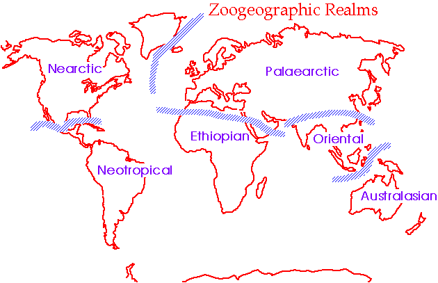
Relative characteristics of developmental disparities
- Less developed
- Low per capita income, scarce capital
- Uneven distribution of wealth in individual countries
- Primary industries like farming, forestry, mining, fishing, etc. occupy an important role in the national economy
- A lion’s share of the population is engaged in agriculture (over 70%)
- Intensive subsistence farming is practiced. Agriculture is characterized by inefficient methods and unemployment or pseudo employment. The yield is low.
- Most of the people live in rural areas (more than 70% of the total population in some cases)
- High birth and death rates. High dependency ratio. Population growth is high.
- Hunger and malnutrition are all-pervasive.
- Diseases of the infection, respiratory and parasitic types are common. Health care services are poor.
- Overcrowding, poor housing facilities, underdeveloped public and sanitation systems prevail.
- A high level of illiteracy prevails which further prevents economic development.
- Gender disparity is high. Women are accorded an inferior status in society.
- Developed
- High per capita income, capital is easily available.
- Wealth evenly distributed within individual countries.
- Manufacturing and service industries are predominant in economies.
- Agriculture employs an insignificant percentage of the population.
- Extensive subsistence farming is practiced. Agriculture is efficient and mechanized. The yield is high.
- Most of the people live in urban areas (more than70%)
- Both birth and death rates are low. High life expectancy.
- The supply of a balanced diet is adequate. Obesity due to overeating is a common problem.
- Incidence of the disease is rare. Health care services are highly efficient
- Adequate housing facilities, sanitation exits. The Man-land ratio is high.
- Highly efficient and integrated educational infrastructure exists.
- The level of women’s emancipation is higher than that in developing countries.
Causes of Regional Imbalances
The causes of regional imbalances are multi-dimensional — deeply rooted in physical geography, history, economics, culture, and political economy. No single cause is sufficient — regional imbalances are always multi-causal.
A. Physical / Geographical Factors
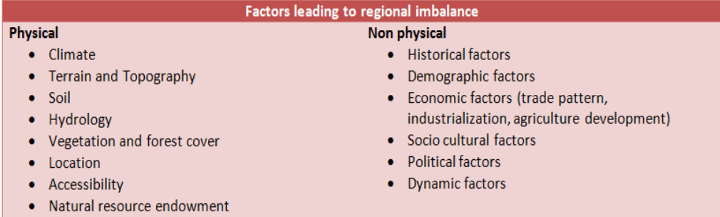
The landscape never follows the “principle of isomorphism.” Natural resources and geographical factors like location and accessibility are not homogeneous across space. Regional imbalances are partly the result of this heterogeneous character of the physical nature of the earth — at one place nature provides all advantages, while others suffer physical constraints to growth.
Vidal de la Blache: “River basins have functional homogeneity and are the gravity centres of civilization where nature is protective and supportive to man.” Most great civilizations arose in river valleys — Nile, Indus, Huang He, Euphrates-Tigris. Soil is the most important natural resource; most river valleys and coastal areas have harboured most of humanity — and their modern successors have inherited these developmental advantages.
- Climate: Temperate climates are generally more conducive to agricultural productivity and human energy. Tropical climates create disease burden and monsoon-dependent agriculture. “Plains invite civilization, mountains push them away, deserts deny them, and coasts augment them.”
- Soil: Fertile alluvial soils of the Indo-Gangetic Plain vs. laterite soils of the Eastern Ghats; black cotton soil of Vidarbha vs. degraded red soils of Rayalaseema.
- Natural resource endowment: North-East India has minerals (oil, coal), hydro-power potential, and biodiversity — yet remains underdeveloped due to inaccessibility and policy neglect. Chota Nagpur has iron ore and coal but remains backward — resources alone do not create development.
- Hydrology: Availability of groundwater, river water, river transport, and fertile alluvium. The Green Revolution succeeded in North-Western India and not in Eastern India primarily because of superior irrigation availability in the northwest.
- Location and accessibility: Western UP near Delhi has a competitive market advantage over Eastern UP. Coastal regions have access to global trade; landlocked regions face higher transaction costs.
B. Historical Factors
- Colonial exploitation: Colonial powers deliberately concentrated infrastructure — railways, ports, industries — in areas that served resource extraction (Mumbai, Kolkata, Chennai). Hinterlands were stripped of raw materials without receiving manufacturing investment. This spatial bias of colonial infrastructure persists to this day.
- Partition effects (India): Partition of 1947 disrupted natural economic regions — Punjab’s irrigation canals, Sindh’s cotton trade, Bengal’s jute industry were severed from their complementary zones, creating sudden regional imbalances.
- Pre-colonial political structures: Regions that were centres of Mughal or Maratha power received cultural and economic patronage — their successors inherited infrastructure and institutional capital. Peripheral regions were exploited tributaries.
- Inertia of industrial location: Once established in a region (historically), industries create cumulative advantages — skilled labour pools, supplier networks, service ecosystems — that are difficult to replicate elsewhere.
C. Economic Factors
- Concentration of industries: In India, industries are concentrated in few regions — Maharashtra, Gujarat, Tamil Nadu, West Bengal — which led to regional imbalances. In 1950, Bengal and the Western region alone accounted for over 59% of India’s total industrial capital.
- Primary sector dominance: A region based predominantly on the primary sector is usually underdeveloped. The primary sector cannot generate income and production of a high order, which leads to low purchasing power of people and inability to save, invest, or diversify.
- Infrastructure deficit: Roads, power, water, telecommunications, banking, education, health — regions deficient in infrastructure cannot attract investment. Infrastructure deficit is both a cause and consequence of backwardness.
- Capital accumulation bias: Capital flows toward regions where returns are highest — already developed regions. Financial institutions historically concentrated lending in developed states (see India data section).
- Green Revolution effects: Government policies like the Green Revolution led to regional imbalances since they succeeded in Punjab, Haryana, and Western UP (with assured irrigation and existing infrastructure) and not in Eastern India or the Deccan, widening the agricultural productivity gap.
D. Socio-Cultural Factors
- Attitude and work ethos: The enterprising nature of Gujaratis, Marwaris, and Jains led to the development of industries and business in their regions. Attitude of people, work ethos, risk-bearing capacity, and cultural attitudes toward entrepreneurship play an important role in differential regional development.
- Social cohesion and institutional quality: Regions with higher social trust, caste cooperation, and effective local governance institutions develop faster (Kerala’s literacy, Tamil Nadu’s industrial clusters).
- Gender inequality: Regions with low female education and labour participation lose half their productive potential — contributing to persistent underdevelopment.
- Law and order: Extremist violence, law and order problems have been obstructing the flow of investments into backward regions besides causing flight of capital from backward states. LWE-affected districts in central India cannot attract investment regardless of resource endowment.
E. Policy Factors
- Industrial licensing policy failures: The Industries Regulation & Development Act (1951) aimed to reduce regional disparities through licensing. In practice, out of 2,293 licenses issued during 1953-61, Bombay, Calcutta, and Madras alone received 35.77%. Maharashtra, West Bengal, Gujarat, and Tamil Nadu collectively received 62.42% of licenses from 1956-66, while Bihar and Orissa received only 6.34%.
- Financial institution bias: Central financial institutions favoured backward areas of developed states over genuinely backward states. Per capita assistance from financial institutions: Bihar received ₹56 vs. Maharashtra’s ₹255 — a 4.5:1 ratio favouring the already-developed state.
- Political economy: Disproportionately high investment in constituencies of influential politicians. In a resource-scarce economy, politically motivated investment allocation deepens regional disparities.
- Centralized planning bias: Early Five Year Plans focused on macro-level sectoral targets without adequate spatial equity considerations. Large public sector investments went to already-accessible locations rather than backward regions.
F. Religion Factors:
- Religion dogma and the religious perceptions which induce the cultural values and govern the social ethos are also responsible for regional imbalances.
Consequences of Regional Imbalances in India
Regional disparities are not merely a geographic curiosity — they have profound economic, social, political, and ecological consequences that threaten national cohesion, growth, and governance.
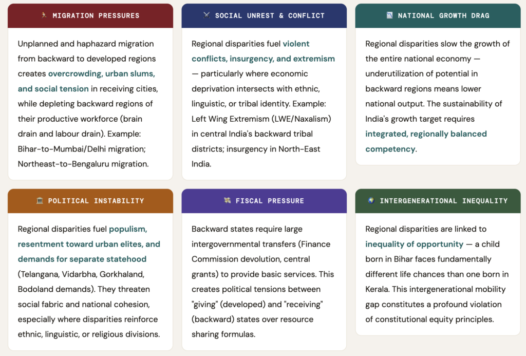
Regional disparities raise equity concerns — they contribute to overall within-country inequality and are linked to inequality of opportunity. “More broadly, regional disparities, including urban-rural differences, can fuel social tensions and pathologies, increase populism and resentment towards urban elites, threaten countries’ social fabric and national cohesion, and in extreme cases lead to conflict, particularly where the disparities reinforce existing ethnic, racial, linguistic, or religious divisions.”
Advantages of the Developed Region
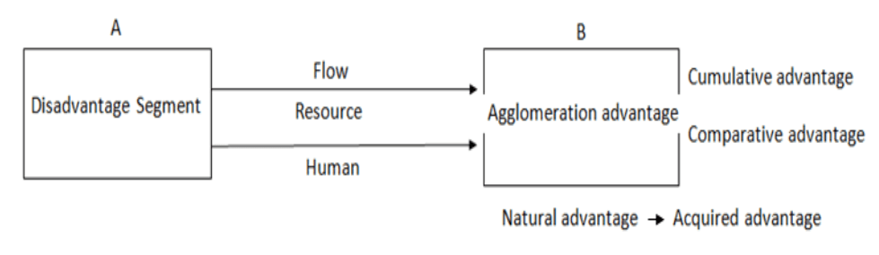
- Natural advantage: It includes location, climate, soil, hydrology, natural resource endowment, accessibility, etc.
- Acquired advantage: It includes the development of infrastructure, the establishment of industries, transportation and communication network, etc.
- Comparative advantage: It includes nearness to market (e.g. Western UP is near to Delhi which offers it a competitive advantage over Eastern UP)
- Cumulative advantage: It includes the development of social sectors, economic sector, industrialization, urbanization, centralization of factors of production, institutional growth and in-migration of skilled and unskilled labour.
- Agglomerative advantage: It includes the traits like capital investment, development of the number of heavy and basic industries and related complementary industries (Here establishment of one industry paves the way for the development of other industries by providing them with common facilities such as power, transport, labour, etc. thus, showing agglomerative effect).
Economic structure and imbalance
- A country based on the primary sector is usually underdeveloped. The primary sector cannot generate income and production of a high order which leads to the low purchasing power of people.
- Regions heavily dependent on the secondary and tertiary sectors have high demand, high income, and high export potential, which leads to the advancement of the economy. Thereafter the quaternary and quinary sector develops.
- Productivity and imbalance– If the efficiency of labor is more then it will increase the productivity in an economy. Good health of workers is directly proportional to high productivity and growth of a region
- Case Study
- Kalahandi district of Orissa is rich in mineral resources around it such as iron ore bauxite etc which has attracted many industries in the region. But the neighboring areas are still backward giving rise to regional imbalance.
- Similarly, the Vidarbha region of Maharashtra is backward even though Western Maharashtra is developed.
Concept of Balanced Growth
- According to Harrod, if in a country the growth rate of per capita income, economic output, and resources are equal, Balanced Growth is said to exist. Balanced growth means equitable development in various sectors of the economy. In a true sense, it means a balance between economic and human development where economic growth complements human development.
Two Dimensions of Balanced Growth
- Spatial Dimension
- Inter-regional balance (e.g., Eastern UP and Western UP developing at similar rates) and intra-regional balance (e.g., Uttar Pradesh and Punjab growing proportionately). The spatial dimension addresses geographic equity.
- Social Dimension
- Class-based balance — regions with people from lower castes developing at rates comparable to higher-caste regions; SC/ST communities accessing equal services and opportunities as general categories.
Balanced Growth — Global vs. Regional Scope
- Global level: The term global disparity describes disparities between nations — the North-South divide where rich countries are resource-endowed or historically advantaged, and poor countries resource-poor or historically exploited. Each country is at a different level of development.
- National/regional level: Within India, disparities between states constitute inter-state (inter-regional) imbalance. Within states, disparities between districts constitute intra-state (intra-regional) imbalance. Both require targeted policy responses.
Economic Backwardness Indicators
- Rengasamy identifies the following as indicators for measuring the degree of backwardness (and thus the distance from balanced growth):
- Road length per sq. km
- Literacy rate
- Hospital beds per thousand population
- Percentage of villages electrified
- Percentage of cultivated land under irrigation
- Longevity (life expectancy)
- Availability of low, intermediate, and high-order functions and facilities
- A low composite total across these indicators suggests backwardness — and thus a large deviation from balanced growth.
Strategies for Correcting Regional Imbalances
- Addressing regional imbalances requires a multi-pronged approach combining fiscal transfers, industrial policy, area-specific programs, and bottom-up governance reform. India has used several strategies since its independence:
A. Fiscal Transfer Mechanisms
- Finance Commission devolution: The Finance Commission uses a needs-based formula — incorporating population, income distance from national average, area, forest cover, and demographic performance — to allocate central tax revenue to states. Backward states receive a larger proportional share to compensate for lower own-revenue capacity.
- Special Category Status (SCS): Hilly, tribal, and frontier states (J&K, HP, Uttarakhand, NE states) received 90:10 central-state funding for plan schemes vs. 60:40 for general category states — recognizing their structural disadvantages.
- Backward Regions Grant Fund (BRGF): Untied grants directly to PRIs in 272 backward districts for infrastructure — bypassing state government to reach the grassroots.
B. Industrial Location Policy
- Public sector investment in backward areas: 2nd Five Year Plan (1956-61) located three integrated steel plants in backward regions — Bhilai (MP/CG), Durgapur (WB), Rourkela (Odisha) — in tune with resource endowment and Weber’s principle of least cost location. The basic assumption was that these would serve as growth poles generating multiplier effects. However, local population mostly received unskilled jobs; displaced communities faced cultural mutation.
- Industrial licensing reform: Post-Pande Committee (1968) attempted to grant more licenses to backward areas — though in practice backward areas of developed states received preference over genuinely backward states.
- Special Economic Zones (SEZs) and Industrial Corridors: DMIC (Delhi-Mumbai Industrial Corridor), Chennai-Bengaluru corridor, and Amritsar-Kolkata corridor as instruments for dispersing industrial growth along transport spines to backward regions.
C. Area-Specific Development Programs
| Programme | Target Area | Approach |
|---|---|---|
| DPAP (1973) | 70+ drought-prone districts | Watershed treatment, soil conservation, alternative livelihoods |
| DDP (1977) | Thar Desert fringe districts | Sand dune stabilisation, shelter belts, water harvesting |
| HADP (5th FYP) | Hill districts — UP, WB, Assam, HP | Horticulture, connectivity, erosion control |
| Tribal Sub-Plan (1974) | Scheduled Tribe areas | Ring-fenced funds proportional to tribal population share |
| IRDP (1980) | BPL rural households | Asset transfer + subsidized credit for self-employment |
| Command Area Development (1974) | Major irrigation command areas | Last-mile water management; warabandi; field channels |
| Aspirational Districts (2018) | 112 most backward districts | Real-time delta-ranking on 49 indicators; convergence of schemes |
D. Decentralization and Governance Reform
- 73rd Constitutional Amendment (1992): Three-tier Panchayati Raj — constitutionalizing the district and sub-district as planning units; mandating women’s representation (33%); enabling grassroots planning through Gram Sabha
- District Planning Committees (DPCs): Article 243ZD mandates DPCs to consolidate GP and urban local body plans into district development plans — enabling bottom-up identification of regional needs
- Kerala People’s Planning Campaign (1996): Devolved 35-40% of state plan funds to local bodies — the most successful implementation of decentralized regional planning globally
E. Spatial Diffusion Strategies (Contagion & Hierarchical)
- Hierarchical diffusion: Development innovations spread top-down through the urban hierarchy — from metropolitan cities to state capitals, to district towns, to tehsil towns, to villages. Growth poles at each level act as relay stations for diffusing development downward. Policy implication: strengthen medium-sized towns as intermediate relay nodes.
- Contagion diffusion: Development spreads outward like a contagion from a centre — geographically adjacent areas benefit before distant ones. Distance from the growth centre determines the sequence of development. Policy implication: ensure spatial connectivity (roads, railways, telecommunications) so contagion spread is not blocked by distance barriers.
F. Planning Approaches for Regional Balance
- Spatial Approach
- Area-specific planning for particular goals keeping local socio-economic and geographical factors in account. E.g., planning to reduce poverty in hilly areas by promoting tourism; watershed development in drought-prone districts.
- Temporal Approach
- Time is the major factor in the planning process. E.g., planning for doubling farmers’ income by 2022 in a particular region; time-bound poverty elimination targets for aspirational districts.
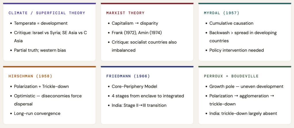
- Central Place Theory, Growth Poles, and Growth Centres are examples of implementation of various planning approaches to reduce regional imbalance. Regional planners identify hierarchical relationships and decide which activity should be located at which level of the hierarchy, so that complementary functions ensure integrated development of the entire region.
- For example, during the 2nd Five Year Plan, three integrated steel plants were located in backward regions (Bhilai, Durgapur, Rourkela) with the expectation that they would serve as growth poles and generate multiplier effects in the hinterland.
Conclusion:
- Regional imbalance is a threat to the goal of inclusive growth and reduction of poverty. The growing regional disparities have dampened the speed of further economic reforms and hence may pose a barrier to India‟s future economic growth.
- Regional disparities will result in regional tensions, which in turn may lead to popular agitations and at some times militant activities also.
- Regional disparities in economic and social development which exist within some of the States due to the neglect of certain backward regions have created and creating demand for separate States like in the past for separate Telangana and now and then for Vidarbha and for Bodo land.
- As such, there is a strong need for strengthening good governance in the backward areas. Towards this end, it is necessary that the local bodies in the backward areas are empowered and strengthened to reduce the regional imbalances in the country.







Thnqq for such valuable content.
Thank u for providing this type of notes for free but Please (request to you) provide straight to the point notes and skip the unnecessary content.Jai Hind…..
baba u r the best
I really want to say thanks from my heart for your effort. It is actually beyond the price.
sir how religion cause regional imbalance can u give some eg ??
religion is one of the factors for population explosion e.g. in some religions there’s a want for male children for the last ritual to be carried on that lead to the birth of more child until a couple gets a baby boy. It may cause overpopulation, and less scope for health and education–the deterioration of human capital. e.g. in U.P., Bihar, and Bengal which are agriculturists have wanted, male children. While Kerela has a good family planning program and a positive sex ratio!
P.S. no factor influences anything in isolate. Intermingling of factors actually causes differentiation.
Need to change the article given in regional development board it’s not 321 D it is 371(2)