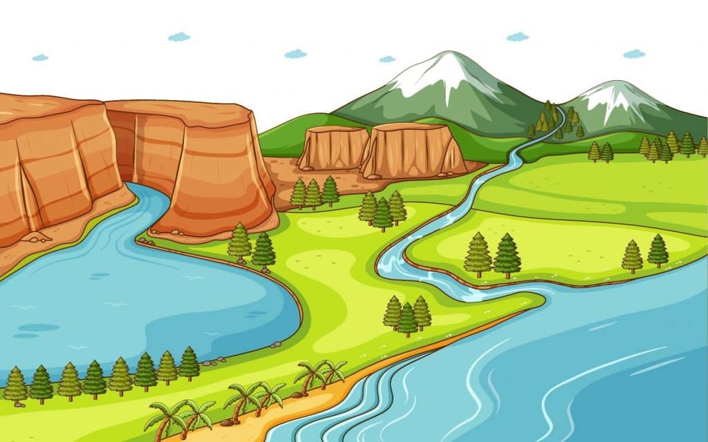
A landform is a feature on the Earth’s surface that is part of the terrain. Endogenic forces and exogenic forces can create a lot of landforms. Mountains, hills, plateaus, and plains are the four major types of landforms. Minor landforms include buttes, canyons, valleys, and basins.
Mountains
- A mountain is a large landform that rises above the surrounding land in a limited area, usually in the form of a peak. A mountain is generally steeper than a hill.
- Mountains are formed through tectonic forces or volcanism. These forces can locally raise the surface of the earth.
- Mountains erode slowly through the action of rivers, weather conditions, and glaciers. A few mountains are isolated summits, but most occur in huge mountain ranges.
- Nearly 27% of the world’s land surface is covered by mountains.
- It is from the mountains that up to 80% of the planet’s fresh surface water come from.
- According to the UN’s Food and Agriculture Organization (FAO), about 12% of the world’s population lives in the mountains, but over 50% are directly or indirectly dependent on mountain resources.
The mountains, on the basis of their mode of formation, can be classified as:
- Fold Mountains
- Block Mountains
- Volcanic Mountains/ Accumulated Mountains
- Residual Mountains/ Relict Mountains
Fold Mountains
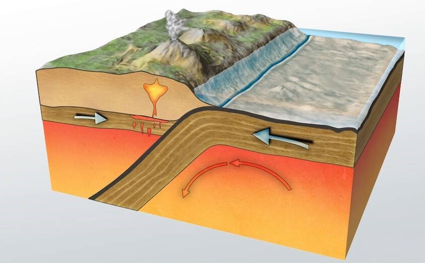
- Fold Mountains are formed as a result of the compression of tectonic plates, which leads to the formation of large fold-like structures on the earth’s crust.
- Fold Mountains primarily exist as mountain ranges, and the majority of the earth’s well-known mountain ranges are examples of Fold Mountains.
- Characteristics of fold mountains
- One common characteristic seen in all fold mountains is their formation. Fold Mountains are all formed through the collision of different tectonic plates along a convergent boundary creating distortions on the earth’s crust.
- Fold Mountains are also characterized by their arcuate shape whereby the mountains’ length greatly exceeds the width. The process of the formation of Fold Mountains involves the exertion of considerable pressure on layers of rock which causes the rocks to metamorphose.
- Fold Mountains is based on their location as these mountains are predominantly situated along the margins of continents with the margins being close to oceans.
- All fold mountains also feature the shape on an arc where one slope is concave shaped while the other slope being convex shaped.
- Formation of fold mountains
- Fold mountains are formed after two continental tectonic plates move towards each other and collide at the destructive plate boundary (also known as the convergent boundary) leading to the development of mountain ranges. The enormous amount of pressure exerted by the rocks distorts the earth’s crust forming folds like those on a piece of cloth but on a massive scale. The folding effect is more profound in regions where the crust has a weak layer such as that made up of salt.
- Types of fold mountains
- There are several thresholds used to distinguish different types of Fold Mountains.
- Age: Fold mountains are classified into young fold mountains (aged between 10 and 15 million years) and old fold mountains (aged 200 million years and above).
- Geography of the mountains: There are either simple fold mountains or complex fold mountains. In simple fold mountains, the synclines and anticlines are well developed creating a wave-like appearance to the mountains while in complex fold mountains, the compression forces cause the formation of a very complex structure known as the nappe.
- There are several thresholds used to distinguish different types of Fold Mountains.
- Examples of fold mountains
- Fold Mountains are found all over the world with most of the world’s tallest peaks being fold mountains. The most famous mountain range in the world, the Himalayas in Asia, is an example of fold mountains. The mountain ranges which are made up of numerous peaks rise over 23,000 feet above sea level, which include the world’s tallest mountain of Mount Everest. The Himalayas were formed by the collision of the Eurasian tectonic plate and the Indian tectonic plate millions of years ago. The Himalayas are young fold mountains when viewed in a geological time frame as they are less than 15 million years old.
- Another example of the Fold Mountains is the Andes Mountains in South America. The Andes is a mountain range that stretches about 4,300 miles in length and has a maximum width of 430 miles. The significant difference between the Andes’ length and width is an essential characteristic seen in all fold mountains. The Andes were formed as a result of tectonic forces which acted between the South American tectonic plate, the Nazca tectonic plate, and the Antarctic tectonic plate.
Block Mountains
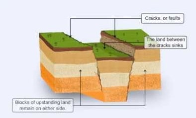
- Block Mountains id defined as the result of faulting caused by tensile and compressive forces motored by endogenetic forces coming from within the earth, also known as fault-block mountains.
- Block mountains represent the upstanding parts of the ground between two faults or on either side of a rift valley or a graben.
- Characteristics of block mountains:
- Block mountains have flat tops or slightly sloping surfaces.
- They have steep sides and they are associated with rift valleys.
- It is a block between two fluids.
- It has fairly steep, straight edges.
- Block Mountains are usually high. Examples of block Mountains include: Voges Mountain, Black forest of the Rhine land.
- Formation of block mountains:
- Block mountains are caused by faults in the crust: a plane where rocks have moved past each other. When rocks on one side of a fault rise relative to the other, it can form a mountain. The uplifted blocks are block mountains or horsts. The intervening dropped blocks are termed graben: these can be small or form extensive rift valley systems. This form of landscape can be seen in East Africa, the Vosges, the Basin and Range Province of Western North America and the Rhine valley. These areas often occur when the regional stress is extensional and the crust is thinned.
- Fault blocks are very large blocks of rock, sometimes hundreds of kilometres in extent, created by tectonic and localized stresses in the Earth’s crust. Large areas of bedrock are broken up into blocks by faults. Blocks are characterized by relatively uniform lithology. The largest of these fault blocks are called crustal blocks. Large crustal blocks broken off from tectonic plates are called terranes. Those terranes which are the full thickness of the lithosphere are called microplates. Continent-sized blocks are called variously microcontinents, continental ribbons, H-blocks, extensional allochthons, and outer highs.
- Because most stresses relate to the tectonic activity of moving plates, most motion between blocks is horizontal, which is parallel to the Earth’s crust by strike-slip faults. However vertical movement of blocks produces much more dramatic results. Landforms (mountains, hills, ridges, lakes, valleys, etc.) are sometimes formed when the faults have a large vertical displacement. Adjacent raised blocks (horsts) and down-dropped blocks (grabens) can form high escarpments. Often the movement of these blocks is accompanied by tilting, due to compaction or stretching of the crust at that point.
Volcanic Mountains
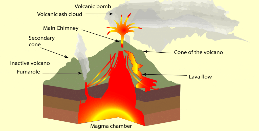
- As the name suggests, volcanic mountains are formed by volcanoes. Volcanic Mountains are formed when molten rock (magma) deep within the earth, erupts, and piles upon the surface. Magna is called lava when it breaks through the earth’s crust. When the ash and lava cools, it builds a cone of rock. Rock and lava pile up, layer on top of layer.
- Charaterstics of volcanic mountains:
- Eruption: Occurs when a volcanic mountain becomes active and eject lava, ashes and chemical gases.
- Explosion: Occurs when a volcanic mountain explodes with thrusts of rocks, fractured stratoplates, molten magma, and bombs producing extreme heats, red hot lava with a mixture of hot water, thick smoke forming combustion of mixed clouds, debris and ash bursting into the atmosphere.
- Expansion: Occurs when a volcanic mountain expands due to molten magma, divided stratoplates, extreme heat, debris causing cooling of rushing lava to form solidified magmalike, expanding land surface of the mountain. During volcanic eruption, the temperature is very hot and can get up to 600oC. Expanded landform areas like this are common in Hawaii.
- Uplift or Inflation: Occurs when a mass of new lava rises to the surface, it pushes the old rock aside and upward making a bulge or uplift on the surface. The process is often called inflation, because the expansion of a volcano due to the lava pushing up inside is similar to inflating a balloon by blowing new air into it. The inflation of a volcano is measured in several ways: by tilt meters that measure the angle of the ground surface, by laser ranging using mirrors placed on the mountain, and by precision surveys using aerial photographs.
- Emulsification: Occurs when a volcanic mountain becomes active, fussing out molten lava which is combine with chemical gases and formation of aqueous fluids with a higher percent of oil. These emulsion fluids gets trapped within very cold layers of the landforms ready to be drilled and exported. An emulsion is a temporarily stable mixture of immiscible fluids, such as oil and water, achieved by finely dividing phase of oil from water. Common emulsions can be oil suspended in water or aqueous phase (o/w) or water suspended in oil (w/o). There also can be more complex systems, such as oil in water in oil (o/w/o). During instances like this, filtration of oil from the collected mixture water is then process to eliminate water.
- Craters: Is a bowl-shaped depression formed by a volcanic eruption or impact of a meteorite.
- Types of volcanic mountains:
- Cinder cone mountains are made up of material blasted out that rains back down. They don’t usually grow too large.
- Shield volcanoes are built up by many lava flows of low viscosity lava (low viscosity means that it flows more easily). The lava can flow for dozens of kilometers, and the volcano can be very wide.
- A stratovolcano or composite volcano is made up of many layers of ash, rock, and hardened lava. Some of the largest, most impressive volcanoes in the world are stratovolcanoes.
- Formation of volcanic mountains:
- The formation of these mountains is triggered by a small crack in the Earth’s crust which, in turn, is attributed to the movement of tectonic plates. This crack allows the magma, i.e. the molten rock within the Earth’s crust, to escape to the surface wherein it cools down and forms various volcanic structures. (The molten rock material which is referred to as magma when it is beneath the Earth’s crust, is referred to as lava when it reaches the surface.) Along with molten rock, volcanic ash and other gases are also introduced into the Earth’s atmosphere during a volcanic eruption. When this volcanic material comes to the surface of the Earth, it settles along with the vent wherein it cools over the course of time and eventually results in the formation of a mountain. While the entire process seems pretty simple, it takes several thousands of years and numerous layers of solidified lava for the formation of volcanic mountains. Such volcanic activity is also seen in the oceans, wherein the buildup of volcanic matter continues for years together and finally results in the formation of islands when it breaches the ocean surface.
- Examples of volcanic mountains:
- Krakatau, Indonesia – The entire island was obliterated by its 1883 eruption, and sunsets around the world changed color for the next two years.
- Lassen Peak, California, USA – erupted in 1917, beginning a period of nearly 75 eruption-free years in the 48 contiguous states.
- Llullaillaco, Argentina/Chile – At more than 22,000 ft, the world’s highest active volcano last erupted in 1877.
- Mauna Loa, Hawaii, USA – This is the world’s largest active volcano. Its most recent eruption was in 1984.
- Mt. Fuji, Japan – This famous symbol of Japan last erupted in 1707.
- Mt. Mazama, Oregon, USA – Crater Lake formed 7,000 years ago when its side blew out and top collapsed.
- Mt. Pelee, Martinique – In 1902 only two of the 30,000 inhabitants of the adjacent town survived its 1902 blast.
- Mt. St. Helens, Washington, USA – It gave several days warning before erupting in 1980, yet 57 people ignored experts advice to relocate and lost their lives.
- Mt. Tambora, Indonesia – The ashes from its 1815 eruption blocked the sun through most of 1816, creating a ―year without summer.‖
- Mt. Vesuvius, Italy – The city of Pompeii was buried under its eruption in the year 79.
Residual Mountains
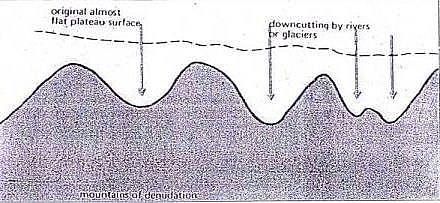
- Residual mountains are those mountains that have been eroded by the agents of degradation such as winds, rain, frost, and running water. The hard rocks that are left behind are called residual mountains.
- Formation of residual mountains:
- Residual mountains are formed from already existing mountains that are lowered or reduced by agents of denudation such as Running water, ice, and wind, Residual mountains are therefore the remains of already existing mountains.
- Some hard, and very resistant parts of the existing mountains remain after the lowering of the upper part. This remaining part is called the Residual Mountains which are also Mountains of Denudation.
- The Aravalli Mountain and the Parasnath mountain of Bihar belong to this type.
- Examples of residual mountains:
- The Nilgiris
- The Parasnath
- The Rajmahal
- The Aravalis
Economic Significance of Mountains
- A storehouse of resources: Mountains are the storehouse of natural resources. Large resources of minerals like petroleum, coal, limestone are found in mountains. The mountains are the main source of timber, lac, medical herbs, etc.
- Generation of hydro-electricity: Hydro-electricity is mainly generated from the waters of perennial rivers in the mountains.
- An abundant source of water: Perennial rivers arising in the snow-fed or heavily rain-fed mountains are one of the important sources of water. They help in promoting the irrigation and provide water for many other purposes.
- Formation of fertile plains: The rivers that originate from the high mountain ranges bring silt along with water to the lower valleys. This helps in the formation of fertile plains and further the expansion of agriculture and related activities.
- Natural political frontiers: The mountains can also act as natural boundaries between the two countries. They have a prominent role in protecting the country from external threats.
- Effects on climate: They serve as a climatic divide between two adjoining regions. The mountains cause orogenic rainfalls, diversion, and blocking of cold winds, etc.
- Tourist centres: The pleasant climate and beautiful sceneries of the mountains have led to their development as centres of tourist attraction.
Plateaus
- A plateau is a flat-topped table land.
- Plateaus occur in every continent and take up a third of the Earths land.
- They are one of the four major landforms, along with mountains, plains, and hills.
- Plateaus, like mountains may be young or old. The Deccan plateau in India is one of the oldest plateaus.
- Valleys form when river water cuts through the plateau. The Columbia Plateau, between the Cascade and Rocky mountains in the northwestern United States, is cut through by the Columbia River.
- Sometimes, a plateau is so eroded that it is broken up into smaller raised sections called Many outlier plateaus are composed of very old, dense rock formations. Iron ore and coal often are found in plateau outliers.
- Plateaus are very useful because they are rich in mineral deposits. As a result, many of the mining areas in the world are located in the plateau areas.
On the basis of their geographical location and structure of rocks, the plateaus can be classified as:
- Intermontane Plateaus
- Piedmont plateaus
- Continental plateaus
- Volcanic plateaus
- Dissected plateaus
Intermontane Plateaus
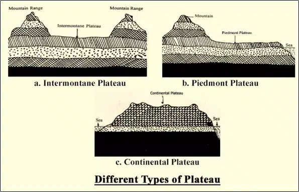
- The plateaus which are bordering the mountain ranges (generally fold mountains) or are partly or fully enclosed within them are the intermontane plateaus.
- The word ‘intermontane’ means ‘between mountains’.
- Intermontane plateaus are the highest in the world.
- They have nearly horizontal rock layers which are raised to very heights by vertical movements of the earth.
- Examples: The Plateau of Tibet is an example of the intermontane plateau which is surrounded by the fold mountains like the Himalayas, the Karakoram, the Kunlun and the Tien Shah.
Piedmont Plateaus
- Plateaus which is situated at the foot of a mountain and is locked on the other side by a plain or a sea/ ocean is called as a piedmont plateau.
- The word ‘piedmont’ means ‘foot of a mountain’.
- They are also called as Plateaus of denudation as the areas once were high to the level of mountains, have now been reduced to the foot level of the mountain by various agents of erosion.
- Examples: The Malwa Plateau is an example of piedmont plateau.
Continental Plateaus
- They are formed either by an extensive continental upliftment or by the spread of horizontal basic lava (less viscous) sheets completely covering the original topography.
- This kind of plateaus shows an abrupt elevation in contrast to the nearby lowland or sea (i.e. more steepness on sides).
- The Continental Plateaus are also known as Plateaus of Accumulation.
- Examples: Plateau of Maharashtra is an example of the continental plateau.
Volcanic Plateaus
- A volcanic plateau is formed by numerous small volcanic eruptions that slowly build up over time, forming a plateau from the resulting lava flows.
- The Columbia Plateau in the northwestern United States of America and Deccan Traps are two such plateaus.
- There are two main types: Lava plateaus and Pyroclastic plateaus.
- Lava plateaus are formed by highly fluid basaltic lava during numerous successive eruptions through numerous vents without violent explosions.
- Pyroclastic volcanic plateaus are produced by massive pyroclastic flows and they are underlain by pyroclastic rocks.
Dissected Plateaus
- A dissected plateau is a plateau area that has been severely eroded so that the relief is sharp. Such an area may appear as mountainous.
- Dissected plateaus are distinguishable from orogenic mountain belts by the lack of folding, metamorphism, extensive faulting, or magmatic activity that accompanies orogeny (mountain building).
- Example : The Catskill Mountains in New York state
The economic significance of Plateaus
- A storehouse of minerals: Most of the minerals in the world are found in plateaus. The extraction of minerals in plateaus is relatively easier on plateaus than mountains. The major portions of industrial raw materials are obtained from plateaus. We get gold from the plateau of Western Australia; copper, diamond and gold from the plateaus of Africa; and coal, iron, manganese and mica from the Chottanagpur Plateau in India.
- Generation of hydel-power: The edges of plateaus form waterfalls which provide ideal sites for generating hydel power.
- Cool climate: The higher parts of the plateaus even in tropical and sub-tropical regions have a cool climate.
- Animal rearing and agriculture: plateaus have large grassland areas suitable for animal rearing especially sheep, goat, and cattle. The lava plateaus when compared to other plateaus are richer in minerals and hence used for agriculture as the soil is very fertile.
Plains
- Plain, any relatively level area of the Earth’s surface exhibiting gentle slopes and small local relief. Plains vary widely in size.
- The smallest occupy only a few hectares, whereas the largest cover hundreds of thousands of square kilometers—as, for example, the Great Plains of North America and the expanse of gently undulating land that sweeps from the Pyrenees Range on the French–Spanish border across northern Europe and Asia almost halfway around the world nearly to the Bering Sea.
- Occupying slightly more than one-third of the terrestrial surface, plains are found on all continents except Antarctica.
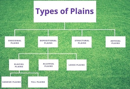
- Most of the plain have been formed by deposition of sediments brought down by rivers. Besides rivers, some plains have also been formed by the action of the wind, moving ice and tectonic activities
- They occur north of the Arctic circle, in the tropics, and in the middle latitudes. Corresponding to their broad geographical distribution, the plains of the world show considerable variation in vegetation.
- Some are tree-covered and others are grassy. Still, others support scrub brush and bunch grass, while a few, which are nearly waterless deserts, have only the most sparse and scanty plant life.
Types of Plains
1. Outwash Plain
- Also called a sandur, an outwash plain is formed by glaciers. Such a plain is formed when a glacier deposits sediments at its terminus. As a glacier moves, it erodes the bedrock and carries the eroded sediments downstream. These sediments are deposited by the meltwater of the glacier at the snout.
- Outwash plains are a common landform in Iceland. The Skeiðarársandur in Iceland is the world’s largest outwash plain with an area of 1,300 square km.
2. Till Plain
- A till plain is also a plain formed by glacial action. Such plains are formed by the deposition of glacial till (unsorted glacial sediment). When a sheet of glacial ice gets detached from the main glacier and melts in place, the sediments are deposited on the ground to result in the formation of a till plain.
- Such plains can be seen in northern Ohio where they were created by the Wisconsin glaciation.
3. Lava Field
- A lava field can also be referred to as a lava plain. Such a plain is formed by the accumulation of layers of lava. The lava plains can stretch for miles and are easily visible from the air or in satellite images where they appear darker in color than the surrounding landscape.
4. Lacustrine Plain
- Lacustrine plains are formed in areas previously occupied by lakes. When a lake drains out completely due to factors like evaporation, natural drainage, etc., the sediments remain behind on the lakebed to form a plain. Such lacustrine plains might be highly fertile and support agriculture or might form a wetland or even a desert depending on the composition of the sediments. Lacustrine plains are common in Southern Indiana of the US where such plains are found in areas formerly occupied by proglacial lakes.
- The Kashmir Valley of India is also an example of a lacustrine plain.
5. Scroll Plain
- Scroll plains are formed in areas where a river meanders across a low gradient. Deposition of sediments at such locations results in the formation of a plain. Oxbow lakes are common occurrences in such areas.
- The Taieri River forms a spectacular scroll plain near Paerau in New Zealand.
6. Flood Plain
- A floodplain refers to a plain that stretches from the banks of a river or stream to the enclosing valley walls. Floodplains are usually subjected to flooding when the adjacent water body overflows. The plains are often fertile and are made of deposits of silts, sands, levees, etc., deposited by floodwaters. Floodplains usually support a rich ecosystem. Many densely populated cities are located on these plains. However, many of the most devastating floods in history have taken place in floodplains.
- The Yellow River’s floodplains are one such area that is frequently subjected to deadly floods.
7. Alluvial Plain
- Alluvial plains are vast, sweeping stretches of plain land that are formed by the deposition of sediments called alluvium. An alluvial plain usually includes floodplains as part of its area but extends beyond such plains. An alluvial plain represents the pattern of floodplain shift over geological time. As a river flows down mountains or hills, it carries sediments resulting from erosion and transports the sediments to the lower plain. As the sediments build up over time, the elevation of the floodplain increases while the width of the river channel decreases. Unable to bear the pressure, the river now looks for an alternative course with a higher channel capacity. Thus, the river forms a meander and flows through a new channel. In this way, floodplains continue growing and adding up to form massive stretches of alluvial plains.
- The Indo-Gangetic Plain in India and the Po Valley in Italy are examples of alluvial plains.
8. Abyssal Plain
- A plain located at great depths on the floor of the ocean is called an abyssal plain. Such plains can be found at depths ranging between 9,800 ft and 20,000 ft. Abyssal plains comprise about 50% of the surface of our planet.
- These regions are some of the world’s least explored areas as well as the flattest and smoothest ones. The abyssal plains are massive in size. For example, the Sohm Plain of the North Atlantic Ocean covers an area of about 900,000 square km.
- Such plains are most common in the Atlantic Ocean but quite rare in the Pacific Ocean. Such plains are considered to be formed by the deposition of sediments, derived from land, in the abyssal depressions. Such deposition occurs in many layers till the underlying irregular features are smoothened out to result in a flat Plain.
The economic significance of Plains
- Fertile soil: The plains generally have deep and fertile soil. As they have a flat surface, the means of irrigation can be easily developed. That is why plains are called as the ‘Food baskets of the world’.
- The growth of industries: The rich agricultural resources, especially of alluvial plains, have helped in the growth of agro-based industries. Since the plains are thickly populated, plenty of labour is available for the intense cultivation and for supplying the workforce for the industries.
- Expansion of means of transportation: The flat surface of plains favours the building of roads, airports and laying down railway lines.
- Centres of civilizations: Plains are centres of many civilizations.
- Setting up of cities and towns: Easy means of transportation on land and the growth of agriculture and industries in plains have resulted in the setting up and expansion of cities and towns. The most developed trade centres and ports of the world are found in the plains only and as much as 80% of the world’s population lives here.
